


Mori Atlas logo
Protected areaŁęgi Odrzańskie

A sprawling 101-kilometer mosaic of floodplain forests, oxbow lakes, and wetland habitats.

Łęgi Odrzańskie: Mapped Boundaries and Protected Riverine Landscapes in Lower Silesian Voivodeship

Łęgi Odrzańskie represents a significant Natura 2000 protected corridor stretching across the Lower Silesian Voivodeship. This expansive riverine landscape preserves a rare mosaic of alder carrs, willow thickets, and wet meadows that follow the natural course of the Oder River. The terrain offers an extensive study of floodplain morphology, functioning as a vital sanctuary for Central European avian species and diverse plant communities within the valley corridor.

floodplain forestswet meadowspeatlandsOder River corridorNatura 2000bird sanctuary
A flat vector-style illustration of a river flowing through a lush valley with deciduous and coniferous trees, a small blue boat moored on the bank, and mountains in the distance.

Łęgi Odrzańskie

Protected area

Park overview

Structured park overview, official facts, and landscape profile for Łęgi Odrzańskie

Łęgi Odrzańskie park facts, protected area profile, and essential visitor context

Review the core facts for Łęgi Odrzańskie, including designation, size, terrain, visitor scale, habitats, and operating context in one park-focused overview.

About Łęgi Odrzańskie

Łęgi Odrzańskie is a large protected corridor of riverine nature in southwestern Poland, recognized within the European Natura 2000 network under the unified site code PLC020002. Geographically the site follows the upper part of the middle Oder valley between Brzeg Dolny and Głogów, covering a 101 kilometer stretch across three distinct physical-geographical units: Pradolina Wrocławska, Obniżenie Ścinawskie and Pradolina Głogowska. Most of the territory lies within Lower Silesian Voivodeship, while a narrow northern tip reaches into Lubusz Voivodeship.

The site exists today as the consolidated successor to two separate Natura 2000 designations. The bird protection area "Łęgi Odrzańskie" (PLB020008) was established in 2007, and the habitat protection area "Łęgi Odrzańskie" (PLH020018) was approved in 2009 and later expanded. In November 2019 the two were merged and their boundaries harmonized, with further boundary modifications to the bird area in February 2022. The current unified area covers approximately 21,350 hectares and provides protection both for individual habitat types and for the bird species that depend on them.

Ecologically Łęgi Odrzańskie is defined by its valley geography. It preserves the surviving fragments of a once continuous system of Oder floodplain wetlands, combining floodplain forests, wet meadows, peatlands, oxbow lakes, salic shrub communities, alder carrs and lower-position riverine oak-hornbeam forests. Roughly seventy percent of the area is formed by eleven habitat types listed in the EU Habitats Directive, including two priority habitats. Plant, invertebrate, fish, amphibian and mammal species of high conservation value occur throughout the corridor, while the bird fauna is exceptionally rich, with around one hundred recorded species.

The combination of habitat richness, geographic continuity along the Oder, and the presence of both Annex I bird species and priority habitat types gives Łęgi Odrzańskie a significance well beyond its immediate region. It is regarded as one of the key riverine ecological corridors of Central Europe, a status formally reflected in its recognition as Important Bird Area IBA PLB089.

Quick facts and research context for Łęgi Odrzańskie

Łęgi Odrzańskie is a Natura 2000 site lying along both banks of the Oder River in southwestern Poland, mainly within Lower Silesian Voivodeship (województwo dolnośląskie), with a small extension into Lubusz Voivodeship (województwo lubuskie). It is registered under site code PLC020002 and was formed by joining the bird protection area PLB020008 (established in 2007) and the habitat protection area PLH020018 (approved in 2009), with formal merger in 2019 and subsequent boundary adjustments.

The area spans roughly 101 kilometers of the Oder valley from Brzeg Dolny upstream to Głogów, crossing the Pradolina Wrocławska, Obniżenie Ścinawskie and Pradolina Głogowska mesoregions. Its habitat base is dominated by floodplain forests, moist meadows and peatlands, and it holds the status of a European Important Bird Area (IBA PLB089), supporting populations of protected birds, mammals, amphibians, fish and invertebrates.

Protection and recognition

Documented conservation status and international designation records for Łęgi Odrzańskie.

Łęgi Odrzańskie Protection Status and Natura 2000 Recognition

Conservation records for Łęgi Odrzańskie assemble mixed protection statuses alongside documented Natura 2000 designations. Designated frameworks provide verified administrative context for evaluating regional protected area boundaries.
Park context

Deeper park guide and search-rich context for Łęgi Odrzańskie

Łęgi Odrzańskie history, landscape, wildlife, and travel context

Explore Łęgi Odrzańskie through its history, landscape character, ecosystems, wildlife, conservation priorities, cultural context, and seasonal travel timing in a structured park guide built for atlas discovery and search intent.

Why Łęgi Odrzańskie stands out

Łęgi Odrzańskie is best known as one of the most significant riverine bird sanctuaries in Central Europe. Its floodplain forests, oxbow lakes and meadows along the Oder host the largest Central European populations of the middle spotted woodpecker (Dendrocoptes medius) and the whooper swan (Cygnus cygnus), alongside important numbers of white-tailed eagle, red and black kites, and collared flycatcher. The site is equally recognized for its diverse floodplain habitat mosaic: riverine forests, willow floodplain shrub, alder swamps, wet meadows and peatland communities arranged along more than a hundred kilometers of the Oder valley. This combination of habitat diversity and continuous river corridor gives the area its strong ecological identity and its status as a merged Natura 2000 bird and habitat site of European importance.
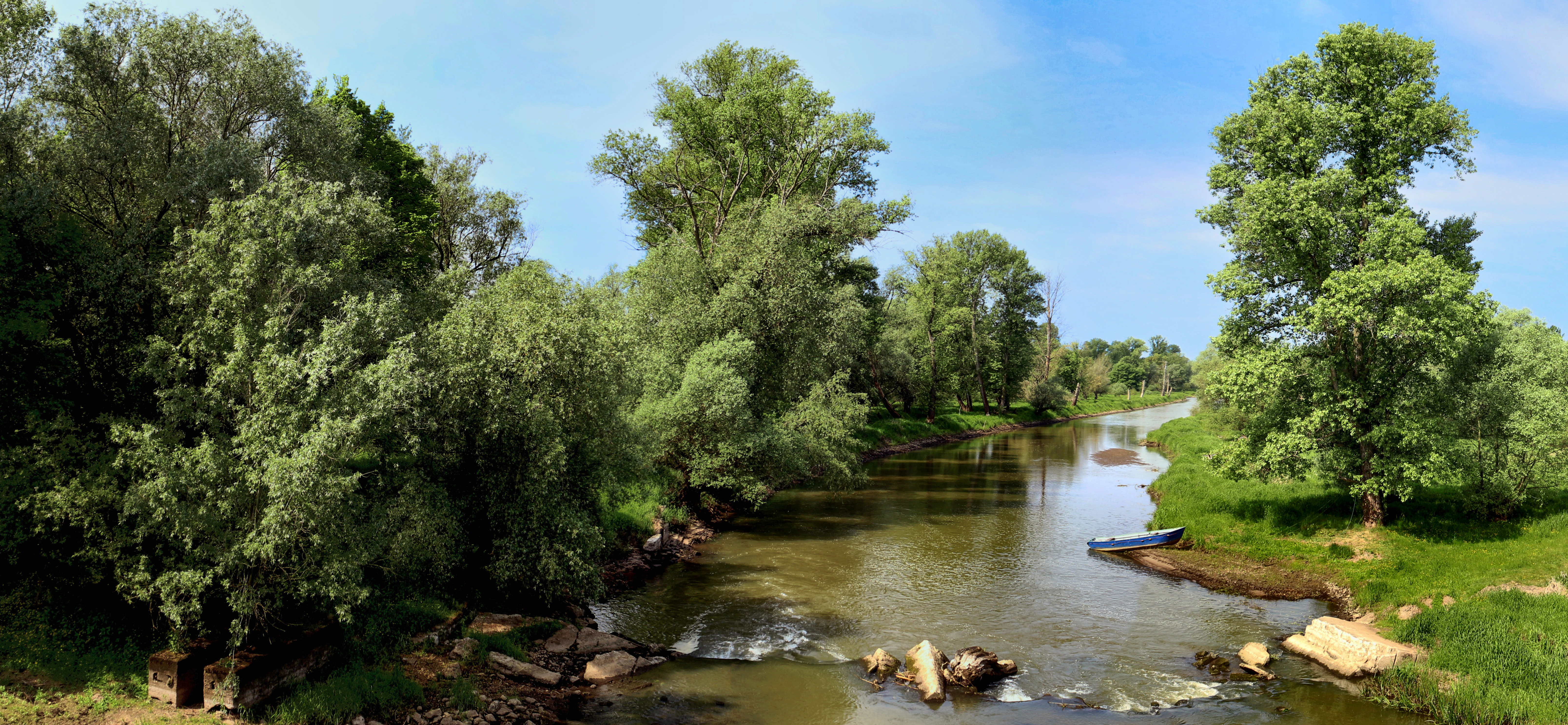
A wide panoramic shot of a river flowing through lush green trees, with a small blue boat moored on the bank.
A panoramic view of the Barycz River flowing through the Łęgi Odrzańskie area.

Łęgi Odrzańskie history and protected-area timeline

Until 1753, the entire Oder valley in this part of Silesia was covered by extensive marshes and bogs, broken only by a few small fishing villages. In the eighteenth century, large-scale drainage works were ordered, which produced roughly 225,690 morgs of new farmland and brought settlers from different parts of the country to cultivate the reclaimed land. As a result of this drainage, most of the original wetland landscape disappeared, leaving only the narrow ribbon of riparian forests and wet habitats that follow the active Oder channel and its floodplain.

Politically the area was part of the Kingdom of Prussia and later of Germany until 1945, when it was incorporated into Poland after the end of the Second World War. The surviving floodplain fragments remained largely intact and later became the basis for modern conservation designations. In 2007 the territory received its first Natura 2000 recognition as a bird protection area (PLB020008), followed in 2009 by parallel designation as a habitat protection area (PLH020018), and in November 2019 the two sites were formally merged into the single Łęgi Odrzańskie site PLC020002, with a further boundary adjustment to the bird component in February 2022.

Łęgi Odrzańskie landscape and geographic character

The landscape of Łęgi Odrzańskie is shaped almost entirely by the middle course of the Oder River and the geological history of its valley. The site stretches 101 kilometers from Brzeg Dolny in the south to Głogów in the north, traversing three classic ice-age and post-glacial morphological units: the Pradolina Wrocławska, the Obniżenie Ścinawskie and the Pradolina Głogowska. Together these form a wide, low-lying valley corridor cut into the surrounding Silesian lowlands.

Within this corridor the terrain alternates between the active river channel, its floodplain terraces, old embankments and depressions. Oxbow lakes mark former river meanders, while shallow groundwater-defined depressions support peatland communities. The result is a finely textured valley floor in which fragments of cultivated land alternate with retained wetland mosaics, wet meadows, willow thickets and patches of floodplain forest. Although the original continuous marshlands were largely drained in the eighteenth century, the surviving natural belt along the river remains a vivid expression of Oder valley morphology and hydrology.

Łęgi Odrzańskie ecosystems, habitats, and plant life

Ecologically Łęgi Odrzańskie is built around a continuous mosaic of floodplain and wetland habitats that together form roughly seventy percent of the site area. According to the current Standard Data Form for the site, eleven habitat types under the EU Habitats Directive occur within Łęgi Odrzańskie, including two priority habitats. The habitat complex reflects the hydrological gradient of the Oder valley and includes floodplain forests, riverine oak-hornbeam woodland, willow floodplain shrub, alder carrs, wet and flooded meadows, peatlands and oxbow water bodies.

Plant diversity within the site includes protected aquatic species such as water caltrop (Trapa natans) and floating watermoss (Salvinia natans), while invertebrate fauna includes rare moths and butterflies such as the Kentish glory (Endromis versicolora, "barczatka kataks" in Polish) and the Scarce Fritillary (Euphydryas maturna, "przeplatka maturna"). The combination of nutrient-rich river water, standing oxbow waters, peatland and seasonally flooded meadows produces a layered habitat structure in which aquatic, wetland, meadow and forest communities are closely interlinked along the valley.

Łęgi Odrzańskie wildlife and species highlights

Fauna is a central element of Łęgi Odrzańskie's identity. The site supports protected populations of two amphibian species, six mammal species, nine invertebrate species and five fish species, together with thirty-five protected bird species. Larger red-listed and internationally protected groups include forty-three species listed in Polish Red Books of plants and animals, thirty-nine rare animal species protected under international conventions, thirty-four species subject to Polish species protection, nineteen additional rare plant and animal species, and thirteen animal species listed in Annex II of the EU Habitats Directive.

The bird fauna is the site's most distinctive ecological feature. Łęgi Odrzańskie qualifies as an Important Bird Area of European rank (IBA PLB089) and supports at least twenty-five bird species listed in Annex I of the EU Birds Directive. Seven species reach nationally important numbers qualifying the area as an IBA: middle spotted woodpecker, white-tailed eagle, grey-headed woodpecker, red kite, black kite, collared flycatcher and whooper swan. A further eighteen Annex I species occur in the area, including European honey buzzard, little bittern, common kingfisher, black woodpecker, great bittern, hen harrier, marsh harrier, black stork, red-backed shrike, aquatic warbler, spotted crake, European nightjar, wood lark, pied flycatcher, ortolan bunting and common crane. In total at least one hundred bird species have been recorded within Łęgi Odrzańskie.

Łęgi Odrzańskie conservation status and protection priorities

Łęgi Odrzańskie is one of the most ecologically significant Natura 2000 sites in southwestern Poland and a key riverine corridor in the broader Central European conservation network. Its importance lies in the preservation of eleven Habitats Directive habitat types, including two priority habitats, along a continuous stretch of the Oder valley, in combination with the protection of thirteen Annex II animal species and twenty-five Annex I bird species.

The site's combined designation as a bird protection area and a habitat protection area, formalized through the 2019 merger, gives it a dual legal status under EU nature law. This is reinforced by national-level protections: Polish species protection lists cover thirty-four plant and animal species present in the area, while Polish Red Books list forty-three species. Yet the area faces clear and ongoing pressures. Documented threats include further drainage of wetlands, dam construction, unregulated development of angling, water pollution, introduction of non-native fish species and the privatization of parts of the forest. These pressures make continued active management of the Oder floodplain corridor essential to maintain its existing habitat and species values.

Łęgi Odrzańskie cultural meaning and human context

The cultural history of Łęgi Odrzańskie is closely tied to the long-term transformation of the Oder valley. Until the mid-eighteenth century the valley supported a sparse pattern of fishing villages set within an extensive wetland landscape. The drainage campaign of 1753 reshaped the region's economy and settlement pattern, producing roughly 225,690 morgs of new farmland and attracting farmers from different parts of the Polish-Lithuanian Commonwealth to settle the reclaimed lands. This transformation is still visible in the present contrast between agricultural land on the drained valley floor and the narrow surviving belt of natural riparian habitats along the active river.

Until 1945 the area belonged to Prussia and later Germany, and its incorporation into Poland after the Second World War set the administrative and demographic framework that still defines the region today. The surviving wetland fragments around the Oder remain an important cultural reference point for local communities, valued both as a distinctive element of regional identity and, increasingly, as a shared natural heritage resource coordinated through regional initiatives such as the Kraina Łęgów Odrzańskich Local Action Group.

Top sights and standout views in Łęgi Odrzańskie

The strongest highlights of Łęgi Odrzańskie are concentrated in three reinforcing themes: habitat continuity, birdlife, and legal protection. The site's most distinctive highlight is its continuous 101-kilometer stretch of Oder valley floodplain, which preserves an unusually intact riverine habitat mosaic featuring willow thickets, alder carrs, riverine forests, wet meadows, peatlands and oxbow lakes.

Equally central is the exceptional birdlife: the site holds what are described as the largest populations of the middle spotted woodpecker and the whooper swan in Central Europe, plus populations of white-tailed eagle, red and black kites, and collared flycatcher of European conservation importance. Reinforcing both is the formal protection framework of EU-level Natura 2000 status, combined national and EU species protections, eleven Habitats Directive habitat types including two priority habitats, and recognition as an Important Bird Area of European rank.

Best time to visit Łęgi Odrzańskie

The character of Łęgi Odrzańskie shifts with the seasons in ways that align closely with the ecology of the Oder floodplain. Spring and early summer are typically the richest period for birdwatching, when breeding songbirds, woodpeckers, raptors and wetland species are most active and detectable across the riverine forests, meadows and oxbows. Late summer and early autumn still offer strong bird activity, with migrating species joining the breeding residents along the Oder corridor.

Because the site is fundamentally a river-floodplain landscape, periods of higher water also enhance the visibility of seasonal flooding across wet meadows and willow floodplain shrub. Cooler months favor viewing larger gatherings of waterbirds and overwintering species, while the wooded sections provide quieter wildlife observation year-round. Visitors should generally expect a dynamic floodplain landscape whose appeal depends strongly on seasonal water levels and bird activity rather than on fixed tourist seasons.

Monthly climate preview

Monthly temperature ranges and long-term precipitation records for protected park terrain

Łęgi Odrzańskie Climate Normals and Average Annual Weather Patterns

Representative coordinates from NASA data reveal long-term temperature swings from sub-zero winter lows to warm summer maximums alongside steady daily precipitation rates across the landscape. Reviewing the full monthly sequence provides deeper context for tracking annual meteorological rhythms within the protected area.
Annual mean9 °C
-2 °C20 °C
Jan-2°
Feb
Mar
Apr
May14°
Jun18°
Jul20°
Aug20°
Sep15°
Oct
Nov
Dec
Warmest month
July

20.4 °C

Coolest month
January

-1.6 °C

Wettest month
July

2.7 mm/day

Driest month
April

1.1 mm/day

Park location guide

Geography guide, regional context, and park location map for Łęgi Odrzańskie

Łęgi Odrzańskie park geography, regions, and map view in Poland

Understand where Łęgi Odrzańskie sits in Poland through a broader geographic reading of the surrounding landscape, nearby location context, and its mapped position within the national park landscape.

How Łęgi Odrzańskie fits into Poland

Poland, officially the Republic of Poland, is a Central European country spanning from the Baltic Sea in the north to the Carpathian Mountains in the south. It borders Germany, Czech Republic, Slovakia, Ukraine, Belarus, Lithuania, and Kaliningrad Oblast. The country has a temperate climate, diverse landscapes, and is known for its rich history, cultural heritage, and strong economic position within the EU.

Wider geography shaping Łęgi Odrzańskie in Poland

Poland occupies 312,696 km2 in Central Europe, extending from the Baltic Sea coast in the north to the Sudetes and Carpathian Mountains in the south. It borders Germany to the west, Czech Republic and Slovakia to the south, Ukraine and Belarus to the east, and Lithuania and Kaliningrad Oblast to the northeast. The landscape includes lowland plains, uplands, and mountain ranges.

Map view of Łęgi Odrzańskie

Use this park location map to pinpoint Łęgi Odrzańskie in Poland, understand its exact geographic position, and read its mapped placement within the surrounding landscape more clearly.

Pigeon | © OpenStreetMap contributors

Location context for Łęgi Odrzańskie

Lower Silesian Voivodeship
Recorded earthquake history

Examine the Seismic Record for the Łęgi Odrzańskie Protected Area

Access the MoriAtlas collection of historical earthquake events associated with the Łęgi Odrzańskie river corridor. This catalogue allows researchers and visitors to review recorded seismic occurrences and their proximity to this significant floodplain landscape through transparent event data.

Łęgi Odrzańskie Earthquake History

Catalogued events

2,217 events

Strongest magnitude

Magnitude 5.8

Most recent event

Aug 12, 2026

This history includes earthquakes recorded inside the park or within 50 km of its borders

Explore floodplain forests, oxbow lakes, and riverine habitats through detailed park photography

Łęgi Odrzańskie Landscapes and Scenery: Visualizing the Oder River Protected Area

Visual documentation captures the complex terrain, floodplain forests, and wetland habitats of Łęgi Odrzańskie along the Oder River corridor. Photographic records reveal the protected landscape character, structural diversity, and natural morphology of this Central European bird sanctuary.

A wide panoramic shot of a river flowing through lush green trees, with a small blue boat moored on the bank.

Park atlas

Compare adjacent river corridors, wetlands, and lowland protected landscapes.

Parks Near Łęgi Odrzańskie and Other Protected Areas in the Region

Browse nearby national parks and protected areas sharing similar riverine valley characteristics with Łęgi Odrzańskie. Comparing these regional conservation landscapes reveals broader ecological patterns across the Central European lowlands.
Nature reservePoland
About 2.5 km away#1 closest

Southeast

Rezerwat przyrody Jodłowice: Nature Reserve Geography and Protected Forest Boundaries in Poland

Glacial valley forest landscapes and rare silver fir conservation

Located in the Lower Silesian Voivodeship, Rezerwat przyrody Jodłowice represents a vital pocket of protected woodland within the Pradolina Wrocławska. This reserve is recognized for maintaining rare forest communities and significant geological remnants, including a massive glacial erratic boulder. It stands as a prime example of localized conservation efforts focused on protecting fragile forest ecosystems and specialized wildlife habitats within the broader Polish landscape.

Area
0.094 km²
Established
1958
Relief
Lowland
Climate
Temperate
Protected areaLower Silesian Voivodeship
22 km away#2 closest

South

Przeplatki nad Bystrzycą Protected Area: Regional Geography and Riverine Habitat Mapping

Protected riparian corridors and floodplain landscapes in southwestern Poland

Trace the three enclaves of Przeplatki nad Bystrzycą across the Lower Silesian Voivodeship. This protected area offers insight into European lowland river systems, where alluvial forests, oxbow lakes, and traditionally managed grasslands form a vital ecological mosaic for rare meadow butterflies and freshwater species.

Area
8.437 km²
A watercolor painting showing a soft, stylized forest landscape with gentle rolling hills in the background, leafy trees in the midground, and ferns and grasses in the foreground.
Nature reserveGreater Poland Voivodeship
About 23 km away#3 closest

Northeast

Rezerwat przyrody Dębno: A Key Protected Nature Reserve in Greater Poland, Poland

Mapping lowland forest ecosystems and ancient oak habitats

Rezerwat przyrody Dębno provides a look into the lowland ecology of Greater Poland through its protected status and renaturation initiatives. This nature reserve, characterized by its ancient oaks and Magnocaricetum communities, highlights the importance of small-scale forest conservation and provides valuable insight into the regional geography of the Kotlina Żmigrodzka.

Area
0.08 km²
Established
1961
Relief
Lowland
Scope
Terrestrial
Nature reserveLubusz Voivodeship
About 28 km away#4 closest

Northwest

Rezerwat przyrody Mesze Nature Reserve: Geographic Analysis of Protected Polish Lands

Post-glacial lake and peatland geography in Lubusz Voivodeship.

Rezerwat przyrody Mesze preserves an essential slice of Polish lowlands geography, showcasing the interaction between post-glacial water-laid sands and lake-driven peat formation. Within this protected valley, the transition from open water to bog communities provides a significant example of natural succession, offering high value for those mapping the diverse terrain of the Sławskie Lakeland region.

Area
0.199 km²
Established
1983
Relief
Lowland
Climate
Temperate
Nature reservePoland
About 30 km away#5 closest

Northwest

Rezerwat przyrody Jezioro Święte: Protected Lake Ecosystems and Glacial Geography

A strictly protected nature reserve in western Poland

Located in the Lubuskie region, Rezerwat przyrody Jezioro Święte serves as a vital safeguard for rare aquatic plant assemblages within a glacial channel lake. The area features unique floating mats and stonewort stands set within a sandy outwash landscape, showcasing the complex environmental history of Polish water systems and long-term natural conservation.

Area
0.194 km²
Established
1983
Water
Water-dominated
Nature reserveGreater Poland Voivodeship
About 30 km away#6 closest

North

Rezerwat przyrody Dolinka: Protected Nature Reserve and Botanical Site in Greater Poland

A focused study of wet meadow conservation in western Poland

Rezerwat przyrody Dolinka is a key protected area in Greater Poland, dedicated to maintaining delicate molinia meadow habitats and native globeflower populations. This site highlights the importance of small-scale nature reserves in preserving botanical diversity within the post-glacial landscapes of the Krzywińskie Lakeland, offering a clear look at local environmental protection in action.

Area
0.018 km²
Established
1974
Relief
Lowland
Climate
Temperate
Protected landscapeLower Silesian Voivodeship
31 km away#7 closest

Southwest

Park Krajobrazowy Chełmy: Protected Landscape and Volcanic Geography in Southwestern Poland

Geological atlas of the Kaczawskie Foothills

Deep dive into the complex terrain of Park Krajobrazowy Chełmy, a protected area in Lower Silesia renowned for its layered volcanic history and unique floristic composition. This site showcases an intricate network of ravines and basalt-crowned hills that define the edge of the Sudetes, offering a comprehensive look at the region's ancient geological development and ecological heritage.

Area
159.91 km²
Established
1992
Relief
Mountain
Climate
Temperate
Nature reservePoland
About 32 km away#8 closest

North

Rezerwat przyrody Jezioro Trzebidzkie Nature Reserve: Geographic Map and Protected Habitat Study

Wetland and forest conservation within the Greater Poland moraine landscape

Investigate the protected boundaries of Rezerwat przyrody Jezioro Trzebidzkie. This faunistic reserve illustrates a transition between shallow lake basin, marshy reed beds, and deciduous forest stands, offering a clear view of postglacial terrain dynamics in the Przemęt commune of Poland.

Area
0.907 km²
Established
2000
Relief
Lowland
Scope
Terrestrial

Common questions about visiting, size, designation, and location context for Łęgi Odrzańskie

Łęgi Odrzańskie FAQs for park facts, access, geography, and protected area context

Find quick answers about Łęgi Odrzańskie, including protected-area facts, park geography, trail and visitor context, and how the park fits into its surrounding country and regional landscape.
MoriAtlas Explorer

Continue Your Protected Areas Search Across the Global Atlas

Deepen your exploration by continuing the structured search for national parks and protected areas worldwide. Utilize the comprehensive filtering capabilities to compare different conservation landscapes and refine your understanding of global park geography. Discover more about the distribution and characteristics of protected natural areas.

Global natural geography