
Mori Atlas logo
Protected landscapeLoch Tummel National Scenic Area

Understanding the terrain, river corridors, and protected boundaries of this iconic Highland water body.

Loch Tummel National Scenic Area: Mapped Geography and Highland Protected Landscape Context

Loch Tummel National Scenic Area represents a core protected landscape within the Perth and Kinross council area, defined by its linear freshwater basin and surrounding forest-clad hills. This atlas entry examines the geographic structure of the Tummel valley, including its hydrologic connections to the River Tay and the scenic corridors that unite diverse Highland terrain. Users can examine how hydro-electric heritage and natural woodland conservation combine to form this distinct Scottish protected area.

Highland lochfreshwater lochriver valleynative woodlandcommercial forestrymountain scenery
A flat-style digital illustration showing a winding river flowing through a forested valley toward a tall mountain with a cascading waterfall.

Loch Tummel National Scenic Area

Protected landscape

Park overview

Structured park overview, official facts, and landscape profile for Loch Tummel National Scenic Area

Loch Tummel National Scenic Area park facts, protected area profile, and essential visitor context

Review the core facts for Loch Tummel National Scenic Area, including designation, size, terrain, visitor scale, habitats, and operating context in one park-focused overview.

About Loch Tummel National Scenic Area

Loch Tummel National Scenic Area protects one of the more recognisable stretches of Highland scenery in Scotland, anchored by the freshwater loch from which it takes its name. The loch lies within Perth and Kinross, northwest of Pitlochry, and sits at the heart of a landscape where water, forest, and mountains meet in compact, highly viewable form.

The scenic area does more than protect the loch in isolation. It covers the hills that rise around it and follows the Tummel valley eastwards to include the Pass of Killiecrankie on the River Garry, recognising that the surrounding terrain shares the loch's visual and ecological character. This makes the designation a corridor-based protection of scenery rather than a single-site reserve, capturing the layered relationship between the loch, the river system that feeds it, and the Highland hills that frame them.

Because the loch is surrounded by roads on both north and south shores, the area is unusually accessible for a Highland landscape. Visitors encounter the scenery directly through travel, walking, and the well-known 'Queen's View' rather than only through dedicated entrances. Forestry managed by Forestry and Land Scotland has also been integrated into the visitor experience as part of the Tay Forest Park, blending commercial woodland management with recreational opportunity.

Underneath the scenic identity, the area carries substantial ecological and historical weight. The loch and its surrounding woods contribute to broader conservation designations protecting salmon, lampreys, capercaillie, and red squirrels, while the surrounding strath preserves Iron Age, Pictish, and early modern settlement evidence. Loch Tummel National Scenic Area therefore stands at the intersection of Highland scenery, freshwater and woodland ecology, hydro-electric infrastructure, and deep cultural heritage.

Quick facts and research context for Loch Tummel National Scenic Area

Loch Tummel National Scenic Area lies entirely within Perth and Kinross in the Scottish Highlands. It takes its name from a long, narrow freshwater loch fed and drained by the River Tummel, and extends across roughly 9,013 hectares of hillside, forest, and valley landscape.

The designation was established in 1981 and is managed by NatureScot as one of Scotland's forty National Scenic Areas, a category created to protect areas of exceptional scenery from certain forms of development. The area overlaps with the River Tay Special Area of Conservation, Tay Forest Park, and the Tummel Hydro-Electric Power Scheme, giving it a layered identity as both a scenic and ecological asset.

Protection and recognition

Documented terrestrial protection metrics and official designation scope

Loch Tummel National Scenic Area Protection Status and International Recognition

Loch Tummel National Scenic Area maintains a documented terrestrial protection status with designated management scopes and administrative boundaries. Verified conservation records assemble official recognition metrics and geographic parameters for thorough reference.

Protection details

Protection scope
Terrestrial
Transboundary protection
No
Park context

Deeper park guide and search-rich context for Loch Tummel National Scenic Area

Loch Tummel National Scenic Area history, landscape, wildlife, and travel context

Explore Loch Tummel National Scenic Area through its history, landscape character, ecosystems, wildlife, conservation priorities, cultural context, and seasonal travel timing in a structured park guide built for atlas discovery and search intent.

Why Loch Tummel National Scenic Area stands out

Loch Tummel National Scenic Area is best known for the loch itself and the panoramic 'Queen's View' from its north shore, which frames the water against the distinctive cone of Schiehallion in the distance. The view, popularised by Queen Victoria in 1866, has become one of the most recognisable scenic images of Highland Perthshire. The area is also defined by the broader Tummel valley corridor, where forest-clad hills, the River Tummel, and the Pass of Killiecrankie combine into a continuous sweep of protected Highland scenery. Its combination of freshwater habitat, native woodland, and historic landscape features makes it a particularly complete expression of the Highland scenery that the National Scenic Area system was created to safeguard.
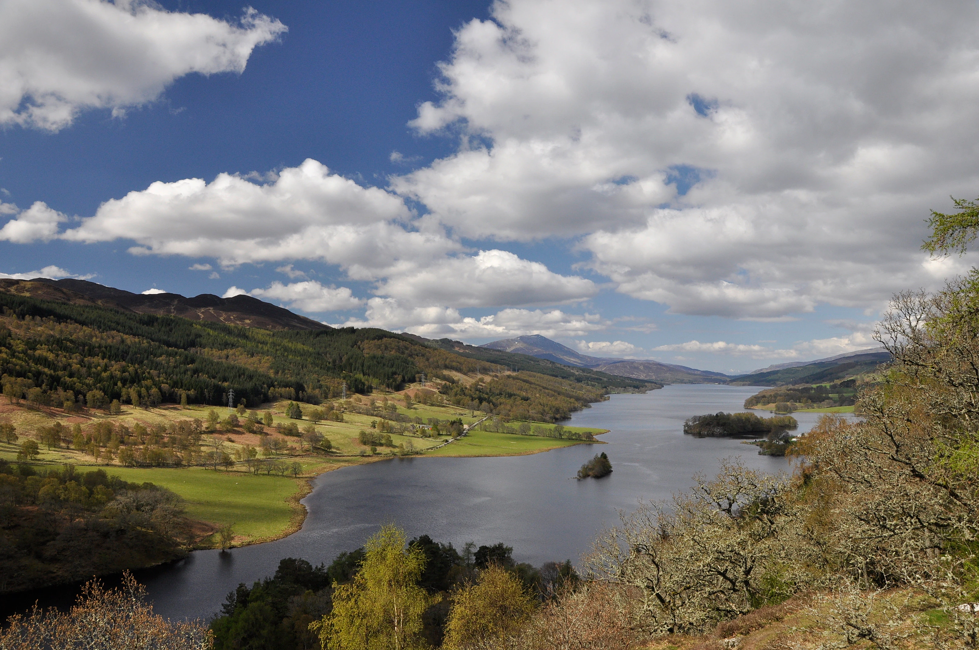
A wide-angle landscape photograph looking down at Loch Tummel in Scotland from a high vantage point, showing the long, narrow lake surrounded by rolling green hills, forests, and a cloudy blue sky.
A scenic view of Loch Tummel from the Queen's View vantage point.

Loch Tummel National Scenic Area history and protected-area timeline

The landscape protected by Loch Tummel National Scenic Area has been occupied and valued for centuries, long before its modern designation. The northern side of the loch holds evidence of Iron Age activity, including a ring fort, abandoned townships, and the remains of Pictish fortified villages, while standing stones at Clachan Aoraidh in the Allean Forest mark an even older ceremonial presence in Glen Fincastle. Fincastle House, a seventeenth-century Category A listed building at the eastern end of the strath, anchors a more recent layer of settlement history.

The loch's modern shape was significantly altered in 1950, when the Clunie Dam was constructed at its eastern end as part of the Tummel Hydro-Electric Power Scheme, raising the water level by several metres and extending the loch to roughly its current length of around eleven kilometres. The drowning submerged at least one previously accessible crannog-style island, which later archaeological work dated to around the early nineteenth century rather than to the deep prehistoric past the structure might suggest. The hydro scheme remains an active feature of the landscape, with power stations operating at both Clunie and Tummel Bridge.

Earlier transport heritage is preserved in the two bridges above the head of the loch. The original humpbacked bridge at Tummel Bridge was built by General Wade around 1734 as part of his programme of road and bridge construction in the Scottish Highlands, and it now stands alongside a modern replacement carrying the B846 to Aberfeldy. From Tummel Bridge, the historic Road to the Isles, also a cattle drove road, branches west into Lochaber, securing Tummel's place in a long tradition of Highland travel routes.

The scenic status of the area was formalised in 1981, when Loch Tummel Lyon was designated a National Scenic Area. This brought it into a Scotland-wide framework intended to identify scenery of national importance and to limit development that could erode that character. The NSA continues to be governed by NatureScot, with its surrounding forests administered by Forestry and Land Scotland as part of the Tay Forest Park.

Loch Tummel National Scenic Area landscape and geographic character

Loch Tummel is a long, narrow freshwater loch oriented roughly east to west through the hills of Highland Perthshire. With a typical shoreline length of around twenty-seven kilometres and a width rarely approaching one kilometre, the loch has a strongly linear character. The water surface sits at roughly 142 metres above sea level and reaches depths of about 44 metres, while the surrounding hills create a sense that the loch is being held in a trough between ridges rather than spreading across open lowland.

The loch is fed and drained by the River Tummel, which joins the River Tay downstream. Its current outline is partly the work of hydro-electric engineering: the construction of the Clunie Dam in 1950 substantially raised the water level and lengthened the loch, so that what was once a shorter, narrower body of water now extends roughly eleven kilometres through the glen. The result is a more expansive vista from viewpoints such as the Queen's View on the north shore, where Schiehallion rises as a distinctive conical landmark above the far end of the loch.

Beyond the loch itself, the National Scenic Area covers the hills that rise from its shores and extends along the River Tummel to incorporate the Pass of Killiecrankie on the River Garry, where woodland clings to a steep, narrow river gorge. Forestry plantations managed by Forestry and Land Scotland soften the transition between loch shore and upland, while natural woodland pockets, open straths, and rocky ridges give the landscape a varied texture. Roads running along both shores, the B8019 to the north and an unclassified road to the south, allow this landscape to be read almost continuously as a scenic drive, which is central to how the area functions as a protected Highland view.

Loch Tummel National Scenic Area ecosystems, habitats, and plant life

The ecological identity of Loch Tummel National Scenic Area is shaped by the interplay between a substantial freshwater loch, the river system that feeds and drains it, and the surrounding mosaic of hillside and woodland. The loch and the River Tummel are integral parts of the wider River Tay catchment, and the water system has been recognised as a Special Area of Conservation for its freshwater character. Brown trout and pike are common in the loch, supporting recreational angling, while the broader river system is valued for salmon, otters, and lamprey species that find suitable spawning and refuge habitat along the Tummel and its tributaries.

The woodland surrounding the loch, particularly along the north shore, is one of the area's most important ecological assets. Native pine and broadleaf woodland, expanded and managed within the Forestry and Land Scotland estate as part of the Tay Forest Park, provides habitat for species that are scarce or declining elsewhere in Scotland. The setting is not a single uniform habitat but a varied one, where plantation, relict native woodland, open glen, and riverside habitat all meet within a relatively short distance, which is part of what gives the National Scenic Area its ecological richness.

Loch Tummel National Scenic Area wildlife and species highlights

Loch Tummel and its surrounding hills support a wildlife community typical of the more wooded parts of the Scottish Highlands, with a mix of freshwater, woodland, and upland species visible across a relatively small area. The loch itself holds brown trout and pike, both of interest to anglers and indicative of a healthy freshwater predator-prey balance, while the wider river system supporting the SAC designation is recognised for Atlantic salmon, European otter, and three species of lamprey: brook lamprey, river lamprey, and sea lamprey.

The woods to the north of the loch are particularly important for species that depend on older native woodland structure. Capercaillie and black grouse, both birds strongly associated with fragile Highland woodland habitats, are present here along with red squirrels, which remain under significant pressure elsewhere in Britain. The invertebrate fauna is also of conservation interest, with pearl-bordered fritillary butterflies recorded in suitable woodland clearings, and juniper stands contribute to a habitat mosaic that supports a wider variety of specialist species. Together, these records give the area meaningful ecological value beyond its scenic role.

Loch Tummel National Scenic Area conservation status and protection priorities

The principal conservation designation covering Loch Tummel is its National Scenic Area status, established in 1981 and governed by NatureScot. National Scenic Areas are one of Scotland's strongest landscape protections, intended to identify areas of national scenic importance and to restrict forms of development that would damage their character. The protection extends well beyond the water itself, covering the hills around the loch and the corridor along the River Tummel and River Garry through the Pass of Killiecrankie.

The water system of the loch and river is also recognised at a European level through the River Tay Special Area of Conservation, which highlights the freshwater and riverside habitat value of the catchment that includes Loch Tummel. This brings additional protection to species such as salmon, otters, and lampreys, and reinforces the ecological importance of the area beyond its scenic identity. The woodland estate around the loch, much of it managed by Forestry and Land Scotland as part of Tay Forest Park, adds a further layer of conservation-focused land management that integrates biodiversity with recreation and timber production.

Conservation pressure in the area is shaped by a mix of factors rather than a single threat. Hydro-electric infrastructure modifies the loch's hydrology, plantation forestry replaces or supplements native woodland, and recreational use brings visitors into sensitive habitats. The combination of scenic, Special Area of Conservation, and forestry designations reflects an attempt to balance these pressures while retaining the landscape and ecological character that make Loch Tummel one of the more representative Highland protected landscapes.

Loch Tummel National Scenic Area cultural meaning and human context

The area around Loch Tummel carries a strong sense of layered Highland culture, where prehistoric, medieval, early modern, and Victorian legacies sit close together. The northern shore holds visible traces of earlier societies, including an Iron Age ring fort, abandoned townships, and Pictish fortified villages, alongside ceremonial standing stones such as those at Clachan Aoraidh in Glen Fincastle. Fincastle House, a seventeenth-century Category A listed building, anchors the more recent architectural heritage at the eastern end of the strath.

The loch is also embedded in Highland travel and military history. General Wade's 1734 humpbacked bridge at Tummel Bridge stands as a tangible reminder of the eighteenth-century programme that opened the Highlands to road-based movement, and from that same point the historic Road to the Isles, long used as a drove road, branches west into Lochaber. Tummel itself is one of the places named in the Scottish folk song that takes this route as its subject, giving the area a small but real place in Scotland's musical and folk tradition.

The 'Queen's View', one of the most visited viewpoints in Highland Perthshire, carries a dual cultural identity. Although popularised by Queen Victoria in 1866, it is also claimed to have been earlier named after Queen Isabel, wife of Robert the Bruce, who is said to have sheltered in the surrounding woods after the defeat at the Battle of Methven in 1306. Whether or not this older attribution is reliable, it ties the loch into broader narratives of Highland royal and political memory.

Top sights and standout views in Loch Tummel National Scenic Area

The defining highlight of Loch Tummel National Scenic Area is the Queen's View on the northern shore, a panoramic outlook over the length of the loch toward Schiehallion that has become one of the most photographed Highland sights in Scotland. From this single vantage point, the loch, the surrounding hills, and the distant mountain come together into a compact, intensely Scottish composition of water, forest, and peak.

Equally important is the wider scenic corridor, which links Loch Tummel to the Pass of Killiecrankie on the River Garry through a continuous band of protected landscape. Together with the loch's hydro-electric story, its angling and sailing, the Tay Forest Park woodlands, and the historical sites scattered around the northern shore, these features make the National Scenic Area a place where scenery, ecology, infrastructure, and heritage all contribute to its identity at once.

Best time to visit Loch Tummel National Scenic Area

Loch Tummel and its surrounding scenery reward visiting at almost any time of year, but spring and summer bring the area to life most visibly. Forests and woodland edges fill with fresh growth, water levels are generally higher after the spring rains, and the loch becomes a busy base for camping, sailing, and angling. The longer daylight of the Highland summer makes viewpoints such as the Queen's View especially generous, with the cone of Schiehallion clearest when afternoon light falls on the open water.

Autumn extends the visitor season into a different mood, with deciduous colour added to the woodland around the loch and quieter roads making the scenic drives more relaxed. Winter brings its own character: bare trees open up new sightlines through the glen, snow can accentuate the surrounding hills, and the loch takes on a quieter, more contemplative atmosphere, though visitors should expect shorter days and more changeable conditions. Shoulder seasons therefore suit visitors who prefer quieter scenery, while late spring and summer suit those who want to combine scenery with active outdoor use of the loch and forests.
Monthly climate preview

Long-term representative point measurements tracking annual temperature and precipitation rhythm

Loch Tummel National Scenic Area Climate Normals and Monthly Weather Records

Representative coordinate records show average temperatures ranging from sub-zero winter minimums to mild summer maximums alongside consistent daily precipitation rates across twelve months. Examining the complete monthly climate profile reveals detailed temperature ranges and precipitation patterns for this protected location.
Annual mean7 °C
1 °C13 °C
Jan
Feb
Mar
Apr
May
Jun11°
Jul13°
Aug13°
Sep10°
Oct
Nov
Dec
Warmest month
July

13.2 °C

Coolest month
January

1.5 °C

Wettest month
October

3.7 mm/day

Driest month
April

2.4 mm/day

Park location guide

Geography guide, regional context, and park location map for Loch Tummel National Scenic Area

Loch Tummel National Scenic Area park geography, regions, and map view in United Kingdom

Understand where Loch Tummel National Scenic Area sits in United Kingdom through a broader geographic reading of the surrounding landscape, nearby location context, and its mapped position within the national park landscape.

How Loch Tummel National Scenic Area fits into United Kingdom

The United Kingdom is a parliamentary constitutional monarchy located in northwestern Europe, consisting of four constituent countries: England, Scotland, Wales, and Northern Ireland. As a major global power with over 69 million residents, it maintains significant international influence in politics, economics, and culture.

Wider geography shaping Loch Tummel National Scenic Area in United Kingdom

The United Kingdom is an island nation located in northwestern Europe, surrounded by the Atlantic Ocean, North Sea, English Channel, Celtic Sea, and Irish Sea. It shares a land border with the Republic of Ireland to the west. The territory includes the island of Great Britain, the northeastern portion of Ireland, and most of the smaller British Isles islands.

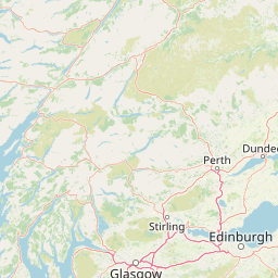
Map view of Loch Tummel National Scenic Area

Use this park location map to pinpoint Loch Tummel National Scenic Area in United Kingdom, understand its exact geographic position, and read its mapped placement within the surrounding landscape more clearly.

Pigeon | © OpenStreetMap contributors

Location context for Loch Tummel National Scenic Area

Perth and KinrossScotland

Visualizing the freshwater lochs, forested hills, and protected Highland terrain

Loch Tummel National Scenic Area Photos and Landscape Scenery

Visual records capture the rugged topography, native woodlands, and expansive valley vistas defining Loch Tummel National Scenic Area. Examining these landscape photographs reveals the complex terrain, freshwater habitats, and scenic protected corridors of the Scottish Highlands.

A wide-angle landscape photograph looking down at Loch Tummel in Scotland from a high vantage point, showing the long, narrow lake surrounded by rolling green hills, forests, and a cloudy blue sky.

A vintage color print overlooking Loch Tummel from a high, rocky vantage point with green hills, fields, and water in the distance.

Park atlas

Compare surrounding Highland valleys, freshwater lochs, and protected natural corridors

Parks Near Loch Tummel National Scenic Area and Regional Protected Landscapes

Browsing parks near Loch Tummel National Scenic Area reveals adjacent Highland valleys, native woodlands, and protected river corridors. Examining these connected protected landscapes expands regional geographic context and deepens comparison across Scottish scenery.
Watercolor painting depicting mountains, forested hills, and a river in a scenic landscape
National parkScotland
About 6 km away#1 closest

North

Cairngorms National Park: Explore Scotland's Largest Protected Mountain Landscape

Mapped boundaries and arctic-alpine geography.

As the United Kingdom's largest national park, Cairngorms National Park in Scotland presents a vast expanse of distinctive arctic-alpine terrain and ancient Caledonian forests. This protected landscape offers a unique opportunity to explore mapped geographic features, from its extensive mountain plateaus to its vital river systems. Discover the contours and context of this significant natural area within the broader atlas of Scotland's protected lands.

Area
4,528 km²
Established
2003
IUCN
V
Visitors
1.9M annual
Watercolor illustration showing mountains, green forests, a loch, and a river in a landscape
National parkScotland
About 35 km away#2 closest

Southwest

Loch Lomond and The Trossachs National Park: Mapped Landscapes and Terrain

Regional geography and protected Highland boundaries in Scotland

Loch Lomond and The Trossachs National Park covers a vast array of protected habitats, from coastal sea lochs to high-altitude Munros. This geographic profile outlines the park's position across the Highland Boundary Fault, highlighting its role as a core protected area for Caledonian forests and freshwater lake ecosystems within Scotland.

Area
1,865 km²
Established
2002
IUCN
V
Visitors
2.9M annual
Protected areaPerth and Kinross
About 44 km away#3 closest

Southeast

Coupar Angus Protected Area: Geographic Boundaries and Regional Landscape Mapping

Located in the Perth and Kinross council area of Scotland

Coupar Angus is a key protected area providing essential insights into the geography and terrain of the Perth and Kinross council area. This detailed mapping overview captures the unique landscape features and boundary distributions characteristic of this Scottish region. Perfect for understanding the spatial configuration and natural setting of the site within its broader local government context.

Area
3.76 km²
Established
1976
Relief
Lowland
Climate
Temperate
A soft watercolor painting of a landscape featuring green rolling hills, a suggestion of a reflective body of water, and layers of purple distant mountains against a light sky.
National parkScotland
About 82 km away#4 closest

Southwest

Loch Lomond and The Trossachs National Park: Geographic and Protected Area Overview

Tracing Highland and Lowland transition zones in Scotland

This protected area captures the contrast between the rugged mountainous terrain of the northern Trossachs and the gentler southern loch basins. By examining the Highland Boundary Fault, users can analyze how glaciers carved the landscape, creating the deep fjord-like trenches and islands that define the region's unique natural geography.

Area
71 km²
Established
2002
Relief
Mountain
Climate
Temperate
Marine protected areaArgyll and Bute
About 83 km away#5 closest

West

Loch Creran Marine Protected Area: Atlas and Coastal Geography of Argyll and Bute

Mapped tidal basins, flame shell reefs, and Atlantic oakwood habitats

Loch Creran is a primary example of integrated marine and coastal conservation on the west coast of Scotland. Characterized by its long, narrow form and dramatic bathymetry, the loch creates a rich environment where rapid tidal currents meet sheltered forest shorelines. This record provides a detailed look at the geographic structure, protected seabed zones, and the transition from sea loch to the ancient woodlands at the head of the inlet.

Area
12 km²
Established
2014
IUCN
IV
Relief
Lowland
A soft, artistic watercolor painting of a Scottish sea loch surrounded by gentle, green hills against a faint mountainous background.
Marine protected areaArgyll and Bute
About 88 km away#6 closest

Southwest

Loch Goil Marine Protected Area: Geography and Landscape Overview

Protected marine habitats in the Argyll and Bute region

Loch Goil offers a distinct look at an enclosed, sea loch landscape in western Scotland. Surrounded by the Arrochar Alps and steep conifer slopes, this marine protected area demonstrates the intersection of Highland wilderness and formal conservation zones. Use this atlas resource to understand its topographical form and regional context.

Established
2014
Relief
Mountain
Climate
Temperate
Access
Moderate access
Marine protected areaScotland
About 105 km away#7 closest

West

Loch Sunart to the Sound of Jura Marine Protected Area: A Scottish Marine Geography Guide

Charting habitat management and Quaternary seabed geology in the western Highlands.

This protected area reaches across the waters of Loch Sunart, the Sound of Mull, the Firth of Lorne, and the Sound of Jura. By mapping this diverse bathymetry, the area safeguards essential marine habitats and the rare common skate population within a complex network of Highland sounds and coastal basins.

Area
741 km²
Established
2014
IUCN
IV
Climate
Temperate
Protected landscapeHighland
About 112 km away#8 closest

West

Morar, Moidart and Ardnamurchan National Scenic Area: Coastal Geography and Protected Lands

A mapped overview of peninsulas, lochs, and Highland terrain

Investigate the protected landscape of Morar, Moidart and Ardnamurchan. This area combines dramatic basalt cliffs, silver sands, and significant historical sites within a remote maritime setting. Gain clarity on the overlapping conservation zones and the complex geography that shapes this distinctive Scottish coastal region.

Area
369.6 km²
Established
1981
Relief
Mixed relief
Access
Moderate access

Common questions about visiting, size, designation, and location context for Loch Tummel National Scenic Area

Loch Tummel National Scenic Area FAQs for park facts, access, geography, and protected area context

Find quick answers about Loch Tummel National Scenic Area, including protected-area facts, park geography, trail and visitor context, and how the park fits into its surrounding country and regional landscape.
MoriAtlas Explorer

Continue Your Protected Areas Search Across the Global Atlas

Deepen your exploration by continuing the structured search for national parks and protected areas worldwide. Utilize the comprehensive filtering capabilities to compare different conservation landscapes and refine your understanding of global park geography. Discover more about the distribution and characteristics of protected natural areas.

Global natural geography