Mori Atlas logo
Protected areaMadriu-Perafita-Claror Valley

Examine the mapped boundaries, glacial terrain, and cultural landscape of this high Pyrenean basin.

Madriu-Perafita-Claror Valley: An In-Depth Look at Andorra's Glacial Mountain Protected Area

(Vall del Madriu-Perafita-Claror)

The Madriu-Perafita-Claror Valley occupies a substantial glacial basin in the southeast of Andorra, encompassing diverse high-alpine terrain that stretches toward the Spanish border. This protected area preserves a unique mosaic of granite ridges, terraced pastures, and historic stone dwellings that illustrate centuries of human adaptation to high-mountain environments. Our geographic analysis provides insight into the valley's role as a major watershed and a vital refuge for rare wildlife within the Pyrenees.

UNESCO World Heritage Siteglacial valleyPyreneescultural landscapeAndorramountain refuges

Madriu-Perafita-Claror Valley

Protected area

Park overview

Structured park overview, official facts, and landscape profile for Madriu-Perafita-Claror Valley

Madriu-Perafita-Claror Valley park facts, protected area profile, and essential visitor context

Review the core facts for Madriu-Perafita-Claror Valley, including designation, size, terrain, visitor scale, habitats, and operating context in one park-focused overview.

About Madriu-Perafita-Claror Valley

The Madriu-Perafita-Claror Valley is one of the most distinctive protected cultural landscapes in the Pyrenees. Located in the southeast of Andorra, the glacial valley has been protected as a UNESCO World Heritage Site since 2004, with a small extension added in 2006. Together with a contrasting escarpment dropping toward the Valira valley to the north, it forms a remote and visually dramatic mountain basin that remains accessible only by foot trails. This isolation has allowed both its natural environment and its historical human imprint to survive largely intact, in stark contrast to the more developed parts of the Principality.

Although the valley is often discussed for its wildlife and scenery, its deeper significance lies in the cultural landscape that has evolved there over more than seven centuries. The terrain preserves evidence of medieval and early-modern Pyrenean life: dwellings built from local granite and schist, terraced fields once used for grain and later for grazing, communal forests managed for charcoal, and the remains of a Catalan-style iron forge abandoned in the late eighteenth century. Small summer-only settlements such as Entremesaigües and Ramio, with their twelve surviving stone houses and attached barns, form the core of this cultural pattern. The valley's tracks, paved in places with flat stones, once linked the area to Catalonia, Roussillon, and the Languedoc, embedding it in a broader trans-Pyrenean exchange of goods and culture.

Modern management of the valley emphasizes the continuation of traditional land uses rather than introducing road access or large-scale tourism. The high pastures continue to support seasonal grazing by sheep, cattle, and horses, and shepherds still occupy small stone huts, known locally as borders, during the summer months, continuing the practice of producing cheese from milk. Approximately one percent of the valley is privately owned around the settlements; the remainder is held and managed communally. Recognized both as a UNESCO site and as a Ramsar Wetland, Madriu-Perafita-Claror stands as a model of how a remote European mountain valley can be preserved as a living landscape, balancing ecological integrity with a deeply rooted cultural heritage.

The valley also forms an important node in long-distance European hiking routes. Both GR 7 and GR 11, together with the GRP circuit around Andorra, pass through the area, and several staffed and unstaffed mountain refuges support overnight stays. Despite this growing presence of hikers, the absence of motorized access has kept the valley's atmosphere of quiet remoteness remarkably well preserved.

Quick facts and research context for Madriu-Perafita-Claror Valley

The Madriu-Perafita-Claror Valley is Andorra's only UNESCO World Heritage Site, inscribed in 2004 and extended in 2006 under cultural criterion (v). It lies in the southeast of the country and covers approximately 4,247 hectares, around nine percent of Andorra's surface. The valley is part of Andorra's second largest watershed basin and features a glacial Pyrenean landscape of high pastures, cliffs, and steep wooded slopes. A portion of the valley is also listed as a Ramsar Wetland, designated in 2013, reflecting its ecological and hydrological value.

Protection and recognition

Documented terrestrial protection scope, designation history, and Ramsar records.

Madriu-Perafita-Claror Valley Protection Status and International Recognition

Madriu-Perafita-Claror Valley maintains an established terrestrial protection scope supported by documented international Ramsar recognition records established in 2013. Structured protected area metrics outline the official designation history and management context for this natural landscape.

International recognition

Protection details

Protection scope
Terrestrial
Designated year
2013
Transboundary protection
No
Park context

Deeper park guide and search-rich context for Madriu-Perafita-Claror Valley

Madriu-Perafita-Claror Valley history, landscape, wildlife, and travel context

Explore Madriu-Perafita-Claror Valley through its history, landscape character, ecosystems, wildlife, conservation priorities, cultural context, and seasonal travel timing in a structured park guide built for atlas discovery and search intent.

Why Madriu-Perafita-Claror Valley stands out

Madriu-Perafita-Claror Valley is best known for being Andorra's only UNESCO World Heritage Site, recognized for the survival of an intact Pyrenean cultural landscape. Its glacial terrain, communal land-use traditions, terraced fields, stone shepherds' huts, and the remains of a Catalan-style iron forge all illustrate centuries of continuous human adaptation to a high mountain environment. The valley is also valued as a refuge for rare and endangered Pyrenean wildlife, protected in part through its Ramsar Wetland designation.
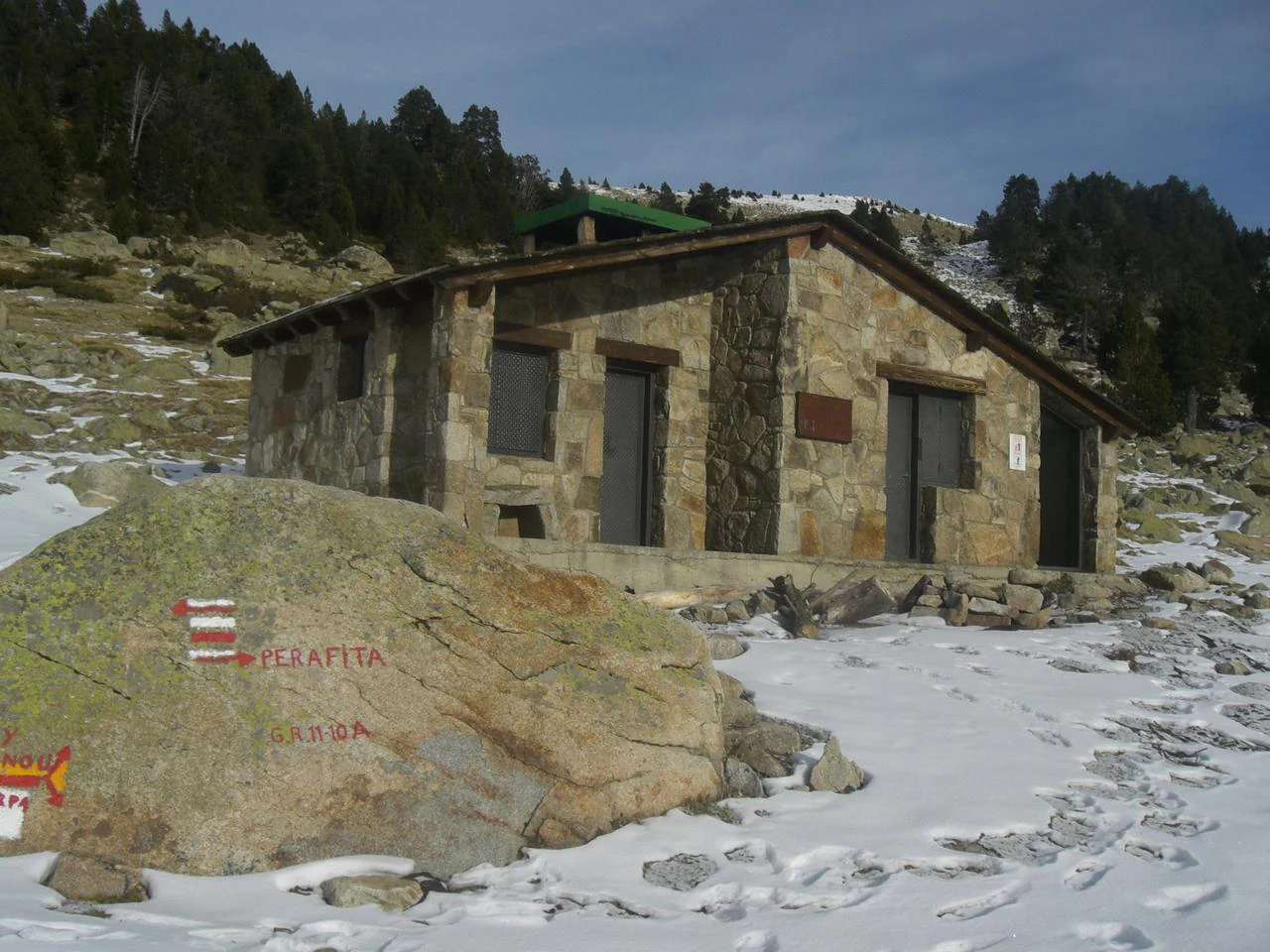
A rustic stone cabin, known as Perafita Refuge, sits on a snow-covered alpine slope with a large rock in the foreground marked by red and white trail signs.
The Perafita Refuge is a traditional stone mountain shelter located within the Madriu-Perafita-Claror Valley.

Madriu-Perafita-Claror Valley history and protected-area timeline

Human activity in the Madriu-Perafita-Claror Valley has been continuous for more than 700 years, evolving alongside climatic shifts, economic changes, and broader social transformations in the Pyrenees. From the Middle Ages onward, the valley was shaped by a complex mix of agriculture, livestock herding, forestry, and metallurgy. The land, with the exception of small plots around the settlements, was held and managed communally, a tradition that helped sustain its integrated land-use pattern across generations.

The valley's two principal settlements, Entremesaigües and Ramio, were inhabited year-round until relatively recent times, but both are now occupied only in summer. Twelve granite houses with schist roofs survive, each paired with a substantial barn for storing grain and hay. Surrounding them are terraced fields that originally produced wheat and rye and have since largely transitioned to grazing. Higher fields have gradually been reclaimed by forest, including former vineyard slopes where grape vines were cultivated in medieval times. The communal forests were historically worked to produce charcoal until the nineteenth century.

Iron smelting using local ore was once an important valley industry. A forge of the typical Pyrenees Catalan style operated along the banks of the Madriu River but was abandoned in 1790, leaving behind physical traces that are now part of the valley's recognized heritage. The valley's tracks once connected it to neighboring regions in Catalonia, Roussillon, and Languedoc, supporting exchange and communication with the wider Pyrenees.

After a period of decline during the twentieth century, conservation and restoration efforts revived many of the valley's traditional structures, including shepherds' huts, dry-stone boundary walls, and historic trackways. In 2004, UNESCO inscribed Madriu-Perafita-Claror as Andorra's first World Heritage Site under cultural criterion (v), reflecting the survival of an outstanding example of Pyrenean mountain living. A small extension followed in 2006, and in 2013 part of the valley was listed as a Ramsar Wetland of international importance, reinforcing its dual natural and cultural significance.

Madriu-Perafita-Claror Valley landscape and geographic character

The Madriu-Perafita-Claror Valley is a classic Pyrenean glacial landscape. Its terrain combines high alpine pastures, craggy cliff faces, and steep wooded side valleys, all enclosed by mountain ridges that bound the valley on the south, east, and west. The southern ridges mark Andorra's border with Spain. To the north, the valley terminates in a steep escarpment that drops down toward the broader Valira valley, creating a dramatic transition between the isolated basin and the more populated corridors of central Andorra.

Geologically, the valley exposes the granite and schist that have shaped both its scenery and its built heritage. The local stone is visible in the houses, barns, and shepherds' huts that punctuate the landscape, integrating human structures visually with the surrounding cliffs and slopes. Field terraces etched into the hillsides, together with the encroaching forest cover on former vineyard and grain land, give the valley a layered appearance where human cultivation and natural regrowth meet.

Water plays a central role in shaping the valley's character. The Madriu River runs through the basin, and the wider watershed of which the valley forms a part is the second largest in Andorra. Combined with glacial deposits and the high cirque headwalls, the river and its tributaries create a varied terrain of boulder fields, moraines, and moist meadow pockets that support both biodiversity and traditional grazing.

Madriu-Perafita-Claror Valley ecosystems, habitats, and plant life

Ecologically, the Madriu-Perafita-Claror Valley is one of the most important protected natural areas in Andorra. Its altitudinal range and its isolation have allowed a rich mosaic of Pyrenean habitats to survive in close proximity. Coniferous and mixed mountain forests clothe the middle slopes, giving way upward to grasslands, alpine meadows, rock fields, and high cliffs that support specialized flora and fauna.

Because the valley is inaccessible by road, its habitats have remained largely undisturbed by large-scale infrastructure. The mosaic of forest edge, open pasture, wetland, and rock outcrop creates transitional zones where wildlife can move between ecological niches across the seasons. The presence of significant wetland habitat is reflected in the valley's Ramsar designation in 2013, recognizing both its hydrological importance and its ecological value at an international level.

The combination of glacial landforms, varied vegetation, and protected land management makes the valley a focal point for understanding Pyrenean ecology.

Madriu-Perafita-Claror Valley wildlife and species highlights

The Madriu-Perafita-Claror Valley is recognized as a haven for rare and endangered wildlife, an attribute that contributed significantly to its recognition under both UNESCO and the Ramsar Convention. The diversity of habitats across elevation supports a wide range of Pyrenean fauna, including species that depend on undisturbed alpine meadows, mature forest stands, rocky cliff systems, and mountain wetlands.

Traditional pastoral activities that continue in summer, including sheep, cattle, and horse grazing, help maintain the open pasture habitats that many high Pyrenean species depend on. The valley's protected status and lack of road access also reduce direct human disturbance, allowing sensitive species to use the area during sensitive periods of the year.

Madriu-Perafita-Claror Valley conservation status and protection priorities

The conservation significance of the Madriu-Perafita-Claror Valley rests on the combination of high ecological value and an exceptionally intact cultural landscape. The valley's status as Andorra's sole UNESCO World Heritage Site, with a cultural landscape designation under criterion (v), reflects the international recognition of how its traditional land-use systems have preserved both natural and cultural heritage over many centuries.

In 2013, part of the valley was inscribed as a Ramsar Wetland, formally recognizing its importance for wetland conservation and reinforcing its profile in international biodiversity frameworks. The deliberate absence of road access, combined with continued communal land management, is central to the valley's conservation approach. Restoration of shepherds' huts, dry-stone walls, and historic tracks has been undertaken in ways that keep traditional structures in active use rather than converting them into purely museum-like relics.

Management policy explicitly favors high-quality livestock farming and limited tourism over large-scale development. By preserving the juxtaposition of forest, pasture, cliffs, and cultural features in a single valley, Madriu-Perafita-Claror functions as a long-term reference site for how Pyrenean landscapes can be conserved as integrated living systems.

Madriu-Perafita-Claror Valley cultural meaning and human context

The cultural landscape of the Madriu-Perafita-Claror Valley reflects a continuous interaction between local communities and a demanding Pyrenean environment. Communal ownership of land since the Middle Ages shaped how forests, fields, and pastures were managed, and it remains a defining element of the valley's identity today. Twelve surviving stone houses, terraced fields, dry-stone trackways, and the remains of a once-active Catalan-style iron forge are tangible expressions of this long-standing relationship between people and place.

Seasonal rhythms continue to influence valley life. Two small settlements, Entremesaigües and Ramio, are occupied mainly in summer, mirroring centuries-old patterns of transhumance and high-pasture use across the Pyrenees. Shepherds still occupy traditional huts, called borders, producing cheese from the milk of their animals and keeping alive techniques that have changed little over generations. Together, these practices situate the valley as a living continuation of Pyrenean mountain culture rather than a static historical relic.

Top sights and standout views in Madriu-Perafita-Claror Valley

Madriu-Perafita-Claror Valley stands out for combining UNESCO World Heritage and Ramsar Wetland recognition in a single remote Pyrenean basin. Its glacial landforms, mosaic of forest and alpine pasture, and well-preserved communal land-use system make it one of the most complete cultural landscapes in the Pyrenees. The preserved stone houses of Entremesaigües and Ramio, the remains of the eighteenth-century iron forge along the Madriu River, and the carefully restored shepherds' huts and trackways together illustrate more than seven centuries of high-mountain living. Its status as a foot-access-only valley, crossed by major long-distance trails including GR 7 and GR 11, enhances both its conservation integrity and its appeal for hikers seeking an unaltered European mountain experience.

Best time to visit Madriu-Perafita-Claror Valley

The character of the Madriu-Perafita-Claror Valley changes noticeably across the seasons. Summer is the most active period, when the high pastures are grazed, the small settlements of Entremesaigües and Ramio come back to life, and mountain refuges along the GR 7, GR 11, and GRP routes are typically staffed. During this season, wildflower meadows are at their peak, the weather is most reliable for hiking, and traditional pastoral life is most visible.

Spring and autumn bring quieter conditions, cooler temperatures, and often more dramatic visibility of the cliffs, glaciers, and forested slopes as light and weather shift. Winter brings snow to much of the valley, restricting access to experienced mountaineers and altering the emphasis from cultural landscape to winter alpine scenery. Visitors interested in the living cultural landscape will find summer especially rewarding, while those drawn to the wilderness and geological character of the valley may prefer the shoulder seasons.
Monthly climate preview

Long-term monthly temperature averages and precipitation measurements for Andorra

Madriu-Perafita-Claror Valley Climate Normals and Annual Weather Patterns

Representative point measurements track the annual progression of average temperatures and daily precipitation rates across the protected elevation. Full monthly comparisons provide deeper analytical context for long-term climate behavior across the protected valley geography.
Annual mean6 °C
-3 °C15 °C
Jan-3°
Feb-2°
Mar
Apr
May
Jun12°
Jul15°
Aug15°
Sep11°
Oct
Nov
Dec-2°
Warmest month
July

15.4 °C

Coolest month
January

-2.5 °C

Wettest month
April

2.3 mm/day

Driest month
July

1.3 mm/day

Park location guide

Geography guide, regional context, and park location map for Madriu-Perafita-Claror Valley

Madriu-Perafita-Claror Valley park geography, regions, and map view in Andorra

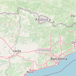
Understand where Madriu-Perafita-Claror Valley sits in Andorra through a broader geographic reading of the surrounding landscape, nearby location context, and its mapped position within the national park landscape.

How Madriu-Perafita-Claror Valley fits into Andorra

Andorra is a small landlocked country in the eastern Pyrenees mountains between France and Spain. Founded in 1278 under a charter linking it to the Diocese of Urgell, it operates as a co-principality with two co-princes: the Bishop of Urgell in Spain and the President of France. With a population of around 89,000 and an area of roughly 468 km², it is one of Europe's smallest nations. Catalan is the official language, though Spanish, Portuguese, and French are widely spoken. The economy relies heavily on tourism and duty-free shopping.

Wider geography shaping Madriu-Perafita-Claror Valley in Andorra

Andorra is situated in the eastern Pyrenees mountains, occupying a valley environment surrounded by peaks and ridges. It is entirely landlocked, bordered by France to the north and Spain to the south. The terrain is predominantly mountainous with valleys and gorges. The country sits at high elevation, with its capital Andorra la Vella at approximately 1,023 meters above sea level, making it the highest capital city in Europe. The Pyrenees form a natural barrier and define the country's mountainous character.

Map view of Madriu-Perafita-Claror Valley

Use this park location map to pinpoint Madriu-Perafita-Claror Valley in Andorra, understand its exact geographic position, and read its mapped placement within the surrounding landscape more clearly.

Pigeon | © OpenStreetMap contributors
Recorded earthquake history

Examine the Recorded Earthquake History of the Madriu-Perafita-Claror Valley

Access a chronological overview of seismic events documented near the Madriu-Perafita-Claror Valley. This catalogue provides valuable historical context regarding regional earth movement and epicentre distribution through the MoriAtlas structured geography platform.

Madriu-Perafita-Claror Valley Earthquake History

Catalogued events

91 events

Strongest magnitude

Magnitude 4.6

Most recent event

Feb 1, 2022

This history includes earthquakes recorded inside the park or within 50 km of its borders

Explore photographic records of glacial terrain, alpine pastures, and historic stone architecture.

Madriu-Perafita-Claror Valley Photos and Landscapes: Visualizing the Pyrenean Protected Area

Examine high-resolution imagery documenting the glacial terrain, rocky escarpments, and wooded side valleys of Madriu-Perafita-Claror Valley. Visual documentation reveals the distinct protected-area character, ancient stone dwellings, and remote mountain habitats preserved across this alpine basin.

A rustic stone cabin, known as Perafita Refuge, sits on a snow-covered alpine slope with a large rock in the foreground marked by red and white trail signs.

Park atlas

Compare regional alpine terrain and connected protected landscapes

Parks Near Madriu-Perafita-Claror Valley and Surrounding Protected Areas

Browsing other parks near Madriu-Perafita-Claror Valley reveals broader Pyrenean mountain geography and connected protected landscapes. Comparing adjacent alpine basins provides deeper context into regional conservation networks and high-altitude terrain.
Watercolor painting of a river winding through a valley with green fields, trees, and distant hills
Protected areaAndorra
7.7 km away#1 closest

Northwest

Parc Natural Comunal de les Valls del Comapedrosa: Andorra's Highest Protected Alpine Landscape

Explore the Pyrenean terrain and mapped boundaries of Andorra's summit park.

Parc Natural Comunal de les Valls del Comapedrosa is the primary high-altitude protected area in Andorra, defined by its rugged alpine terrain and the presence of Coma Pedrosa, the country's highest peak. This protected landscape offers a significant geographic anchor for exploring the Pyrenees, highlighting the unique mountain conservation efforts. Its mapped boundaries encompass dramatic valleys and steep ridges, providing a clear context for understanding Andorra's mountainous geography through a structured atlas lens.

Area
15.43 km²
Established
2003
IUCN
IV
Relief
Mountain
Watercolor illustration of a mountainous landscape with a river, green vegetation, and distant peaks under a light sky
National parkProvince of Lleida
39 km away#2 closest

West

Aigüestortes i Estany de Sant Maurici National Park: Pyrenean High Mountain National Park Landscape

Explore glacial lakes and winding waterways in Catalonia.

Aigüestortes i Estany de Sant Maurici National Park is a premier national park in the Pyrenees, celebrated for its extensive network of almost 200 glacial lakes and the dramatic natural beauty of the Sant Maurici lake. Its landscape is defined by high mountain terrain, characterized by U-shaped valleys, sharp ridges, and unique hydrological features like the Aigüestortes plain's meandering streams. This protected area in the Province of Lleida offers a rich setting for understanding alpine environments and Pyrenean geography through detailed mapping and atlas exploration.

Area
141 km²
Established
1955
IUCN
II
Visitors
525K annual
Nature reserveOccitanie
About 45 km away#3 closest

Northeast

Réserve naturelle nationale de la Grotte du T.M. 71: Geological Protected Area Map

Subterranean karst exploration in the Aude department of Occitanie

Located in the foothills bordering the Pyrenees, the Réserve naturelle nationale de la Grotte du T.M. 71 protects a sprawling network of limestone passages. This site represents a key protected area for the study of subterranean mineral formations and Pyrenean karst evolution, featuring kilometres of mapped galleries maintained under a strict integral conservation framework.

Area
0.96 km²
Established
1987
IUCN
III
Nature reserveOccitanie
About 50 km away#4 closest

East

Réserve naturelle régionale de Nyer: Mapped Geography and Protected Mountain Landscapes

Exploring the vertical terrain of a Pyrenean regional nature reserve

The Réserve naturelle régionale de Nyer offers a remarkable study in vertical zonation, featuring deep gorges and high alpine summits within the Pyrénées-Orientales. This protected area stands as a focal point for understanding the convergence of Mediterranean and mountain climates across the diverse topographical landscape of the Occitanie region.

Area
21.9 km²
Established
1998
Relief
Mountain
Climate
Mediterranean
A watercolor painting of a serene mountain landscape featuring gentle rolling hills, small clusters of trees, and soft, muted tones of green, pink, and purple, set against a light background.
Nature reserveOccitanie
About 99 km away#5 closest

Northwest

Réserve naturelle régionale du Massif du Montious: Regional Nature Reserve in Occitanie

Granitic massif geography and Pyrenean protected landscapes

Located in the heart of the Hautes-Pyrénées, this reserve captures the geological and biological essence of the Central Pyrenees. From the summit grasslands at 2,171 metres to the sheltered glacial basins, the terrain provides a comprehensive look at regional mountain ecosystems and Hercynian geological heritage.

Area
7.38 km²
Established
2020
IUCN
IV
A soft, watercolor painting depicting distant purple-hued mountain ranges fading into a pale, warm-toned sky, with light green hills and hints of pine forests in the foreground.
Nature reserveOccitanie
About 109 km away#6 closest

West

Réserve naturelle régionale d'Aulon: Mountain Geography and Protected Area Mapping

A diverse protected landscape spanning the central Pyrenees of Occitanie.

This regional nature reserve provides a focused look at central Pyrenean mountain environments. Covering over 1,200 hectares, the area features a steep altitudinal gradient, blending working pastoral meadows with critical habitats such as rocky slopes, conifer forests, and glacial landforms. The site serves as a vital anchor within the broader network of protected mountain terrain found throughout the Occitanie region.

Area
12.37 km²
Established
2001
IUCN
IV
Relief
Mountain
Watercolor painting of a tranquil natural landscape with a stream flowing through grassy hills, wildflowers, and a backdrop of distant purple-toned mountains.
Nature reserveOccitanie
About 111 km away#7 closest

East

Réserve naturelle nationale de la forêt de la Massane: Geographic and Protected Area Map

Ancient beech forest terrain in the Occitanie mountain landscape

Situated in the upper valley of the Massane river, this protected reserve provides a rare glimpse into ancient forest evolution. With its dense concentration of documented species and unique geological base, it stands as a reference point for studying climate change impacts on Mediterranean mountain terrain and protected woodland architecture.

Area
3.4 km²
Established
1973
IUCN
IV
Visitors
40K annual
A wide, soft-focus watercolor painting showing a winding river through a lush green valley with rolling hills in the background.
Nature reserveOccitanie
About 113 km away#8 closest

North

Réserve naturelle régionale Confluence Garonne-Ariège: Protected Riverine Geography and Mapping

A significant riparian landscape in the Occitanie region

Discover the protected river corridors and diverse natural terrain of the Réserve naturelle régionale Confluence Garonne-Ariège. This regional nature reserve marks the confluence of the Garonne and Ariège rivers, showcasing a complex mosaic of alluvial forest, riparian wetlands, and dry hillside woodlands that characterize the geography south of Toulouse.

Area
5.791 km²
Established
2015
IUCN
IV
Relief
Mixed relief

Common questions about visiting, size, designation, and location context for Madriu-Perafita-Claror Valley

Madriu-Perafita-Claror Valley FAQs for park facts, access, geography, and protected area context

Find quick answers about Madriu-Perafita-Claror Valley, including protected-area facts, park geography, trail and visitor context, and how the park fits into its surrounding country and regional landscape.
MoriAtlas Explorer

Continue Your Protected Areas Search Across the Global Atlas

Deepen your exploration by continuing the structured search for national parks and protected areas worldwide. Utilize the comprehensive filtering capabilities to compare different conservation landscapes and refine your understanding of global park geography. Discover more about the distribution and characteristics of protected natural areas.

Global natural geography