
Mori Atlas logo
Natural monumentMalý Kosatín

A study in traditional grassland conservation nestled among the wooded ridges of the Písek District

Malý Kosatín Natural Monument: Mapping the Orchid Meadows of the South Bohemian Landscape

(Přírodní památka Malý Kosatín)

Malý Kosatín stands as a vital protected area within the Jihočeský kraj region of the Czech Republic, encompassing a rare, species-rich wet meadow that sustains high populations of the May orchid and marsh grass-of-Parnassus. The site illustrates the intersection of traditional agricultural land use and critical habitat maintenance within a mosaic of fen-meadow communities. Its geographic position beneath the hills of Velký Kosatín and Malý Kosatín highlights a landscape defined by gentle slopes, crystalline ridges, and deep botanical significance.

wet meadowfen meadoworchid habitatorchidsMay orchidnatural monument
A stylized vector illustration of a natural scene featuring a large, moss-covered boulder in the foreground, a winding stream, a distant waterfall, and surrounding coniferous forest under a soft, setting sun.

Malý Kosatín

Natural monument

Park overview

Structured park overview, official facts, and landscape profile for Malý Kosatín

Malý Kosatín park facts, protected area profile, and essential visitor context

Review the core facts for Malý Kosatín, including designation, size, terrain, visitor scale, habitats, and operating context in one park-focused overview.

About Malý Kosatín

Malý Kosatín sits quietly in the Benešovská pahorkatina upland, within the Mirovická vrchovina subunit, where gentle hilltops merge into forests and a network of small farm meadows. The protected zone lies amid this older cultural landscape, tucked into the forested slopes beneath the hills Velký Kosatín (548 m) and Malý Kosatín (500 m). The area's identity is shaped both by the soft topography of mid-elevation Bohemia and by centuries of traditional grassland use that have produced a meadow of exceptional species richness.

The site's core is a permanently moist meadow sloping gently to the south above the Kostarecký potok stream, whose waters eventually join the Lomnice and then the Otava, part of the North Sea drainage basin. Geologically, the meadow lies in the so-called Mirovice metamorphic island, with bedrock of biotite-amphibole orthogneiss mantled by Holocene deluvial and fluvial sandy clays; nearby, the rocks meet an intrusion of amphibole-biotite granodiorite of the Central Bohemian Pluton. The soils are acidic to strongly acidic cambisols, locally transitioning to gley soils and thin organic horizons, conditions well suited to the fen-meadow flora.

Climatically, Malý Kosatín falls within the mild Czech climatic region MT11, characterized by a moderately warm winter and long, warm, relatively dry summer, with mean annual temperatures near 7.5 °C and precipitation around 600 mm. These conditions, combined with consistent moisture and the absence of intensive fertilizer use on the protected parcel, have allowed a remarkable botanical community to persist. Visitors discover the meadow not as a sweeping wilderness but as an intensely alive patch of flowering grassland, an emblem of how small, well-placed protection can preserve nationally rare species.

Although the actual reserve is not open to the public, its significance is communicated through the nearby Alšova naučná stezka educational trail, which connects Mirotice, the Kosatínský viklan erratic boulder, and Čimelice. Malý Kosatín thus functions both as a living botanical sanctuary and as a quiet reference point in the broader Bohemian network of small protected natural monuments.

Quick facts and research context for Malý Kosatín

Malý Kosatín is a Czech natural monument (přírodní památka) classified under IUCN Category IV as a species management area. It lies in the Jihočeský kraj, Písek District, in the cadastral area of the village of Boudy, roughly one kilometer northwest of that settlement and north of the town of Mirotice. The protected area covers about 0.95 hectares (the underlying survey gives 0.9691 ha) at an altitude between about 476 and 480 meters, on a gentle south-facing slope.

The site was first declared on 4 December 1985 by the Písek District National Committee, with effect from 1 February 1986, then re-declared by the South Bohemian Regional Authority on 8 March 2011, effective from 13 April 2011, following a 2006 remapping of its boundaries. It is administered under the AOPK České Budějovice nature conservation center. Its protection purpose is to safeguard a wet fen meadow whose May orchid population reaches several hundred individuals and whose Parnassia palustris population numbers in the tens.

Protection and recognition

Documented terrestrial protection history and conservation framework data

Malý Kosatín Protection Status and Designated Area Recognition

Malý Kosatín maintains a documented terrestrial protection status established in two thousand eleven. Structured records outline the official designation history and management scope associated with the protected landscape.

Protection details

Protection scope
Terrestrial
Designated year
2011
Transboundary protection
No
Park context

Deeper park guide and search-rich context for Malý Kosatín

Malý Kosatín history, landscape, wildlife, and travel context

Explore Malý Kosatín through its history, landscape character, ecosystems, wildlife, conservation priorities, cultural context, and seasonal travel timing in a structured park guide built for atlas discovery and search intent.

Why Malý Kosatín stands out

Malý Kosatín is best known as one of the most important orchid-rich wet meadows in the South Bohemian countryside, distinguished by a remarkably dense population of the May orchid (Dactylorhiza majalis) and a strong population of the threatened marsh grass-of-Parnassus (Parnassia palustris). The site also gains attention for its rich variety of sedges, cotton grasses, and other fen-meadow species belonging to a mosaic of Calthion, Caricion fuscae, and Molinion communities. The natural monument embodies the conservation value of small, traditionally mown wet grasslands inside larger forest complexes. Although tiny in area, its botanical intensity, the presence of vulnerable species, and its dependence on continuing traditional management make it disproportionate to its size in conservation terms.
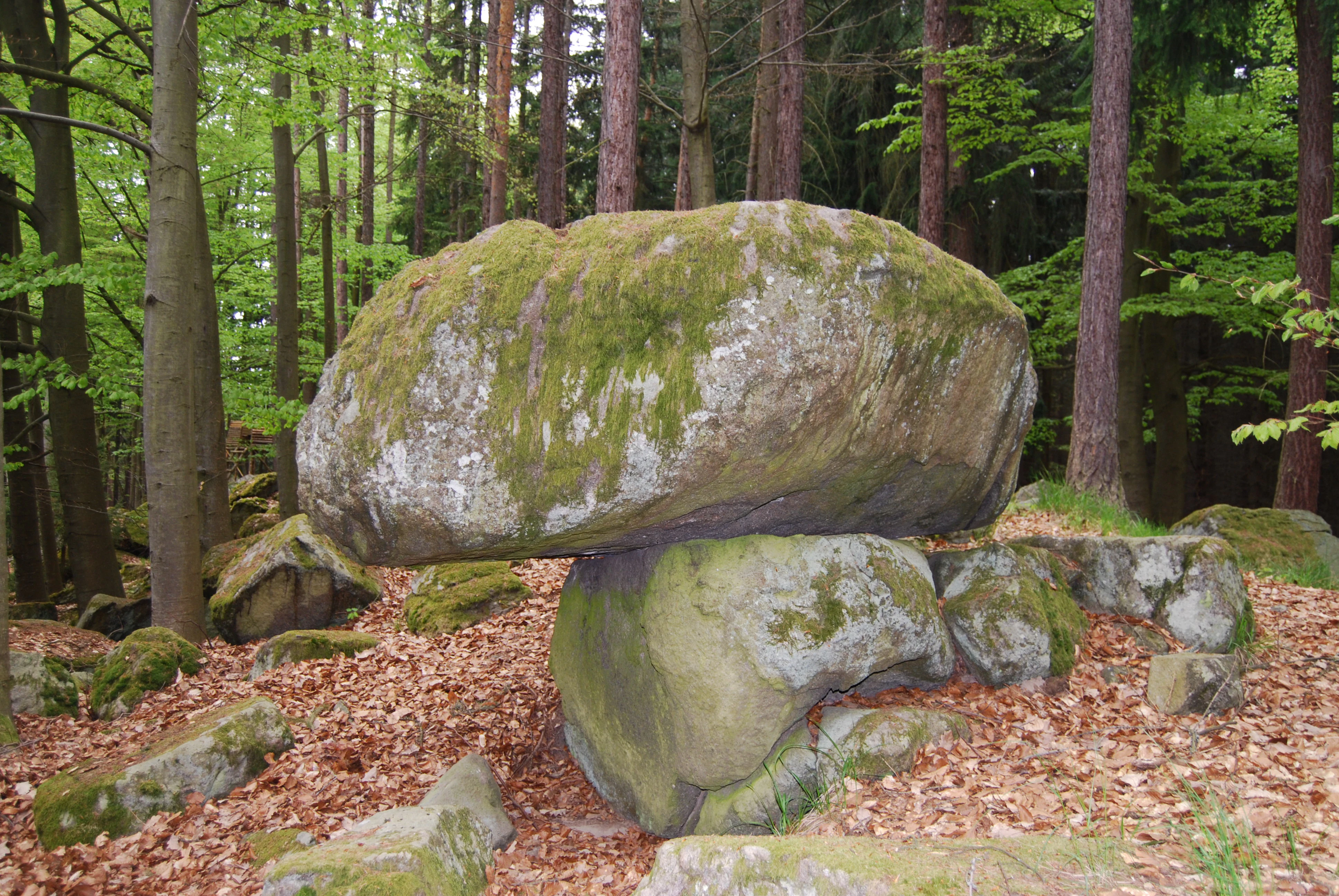
A large moss-covered boulder precariously balanced on a smaller stone base in a forest setting.
A moss-covered balancing rock, or viklan, nestled within the forest of Malý Kosatín.

Malý Kosatín history and protected-area timeline

The wet meadow at Malý Kosatín has a long history rooted in traditional Bohemian rural land use. Surrounded by a large forest complex, the meadow was historically part of a stable mowing regime; by the late twentieth century, mown meadows across the region were increasingly rare, making the survival of this site especially significant. Botanical surveys in the mid-1990s recorded that the meadow was being maintained by an elderly couple from the village of Boudy, who cut the grass by hand each year.

Formal protection began on 4 December 1985, when the Písek District National Committee issued a declaration establishing Malý Kosatín as a protected natural monument, with effect from 1 February 1986. Surveys carried out in 1994 documented not only the meadow's species composition but also the human story of its upkeep, contrasting the carefully manual mowing of the protected plot with the mechanized, fertilized, and limed management applied to meadows higher up the slope by a private farmer.

By 2006, the boundaries of the monument were re-surveyed to match the actual state of the habitat, and on 8 March 2011 the South Bohemian Regional Authority re-declared the site with effect from 13 April 2011, consolidating its legal status. A management plan covering 2009 to 2018 was approved on 15 September 2009, prepared by the EIA Servis České Budějovice company. Since around 2005, regular autumn mowing has been documented in the reserve's logbook, gradually undertaken by the regional authority that took over responsibility for the site's upkeep.

Malý Kosatín landscape and geographic character

The landscape around Malý Kosatín is shaped by the soft, rounded forms of the Benešovská pahorkatina, a transitional upland between lowland Bohemia and the higher ranges to the south. Within that broader setting lies the Mirovická vrchovina, a subunit of wooded ridges and meadows where crystalline basement rocks rise close to the surface. Two named hills, Velký Kosatín at 548 m and Malý Kosatín at 500 m, frame the protected site, providing both visual landmarks and the slight rises that create the local watershed pattern.

The protected area itself occupies a small, gentle south-facing slope between roughly 476 and 480 m in altitude, just under one hectare in extent, wedged between forest, an adjacent road, and continuing agricultural meadows. The terrain is subtle rather than dramatic; the meadow's character depends more on soils, hydrology, and vegetation than on topographic grandeur. Surrounding land cover includes coniferous and mixed forest, including recent clear-cut patches, the course of the Kostarecký potok, and adjacent mown fields that border but do not intrude into the reserve.

Outside the immediate site, the wider landscape continues in the same gentle, undulating pattern: small villages, forest blocks, and pastures separated by quiet country roads. The Kosatínský viklan, a glacial erratic boulder of geological interest, lies near the protected meadow and forms a striking natural monument of a different kind, giving the whole Kosatín area a distinctive blend of botanical and geological character.
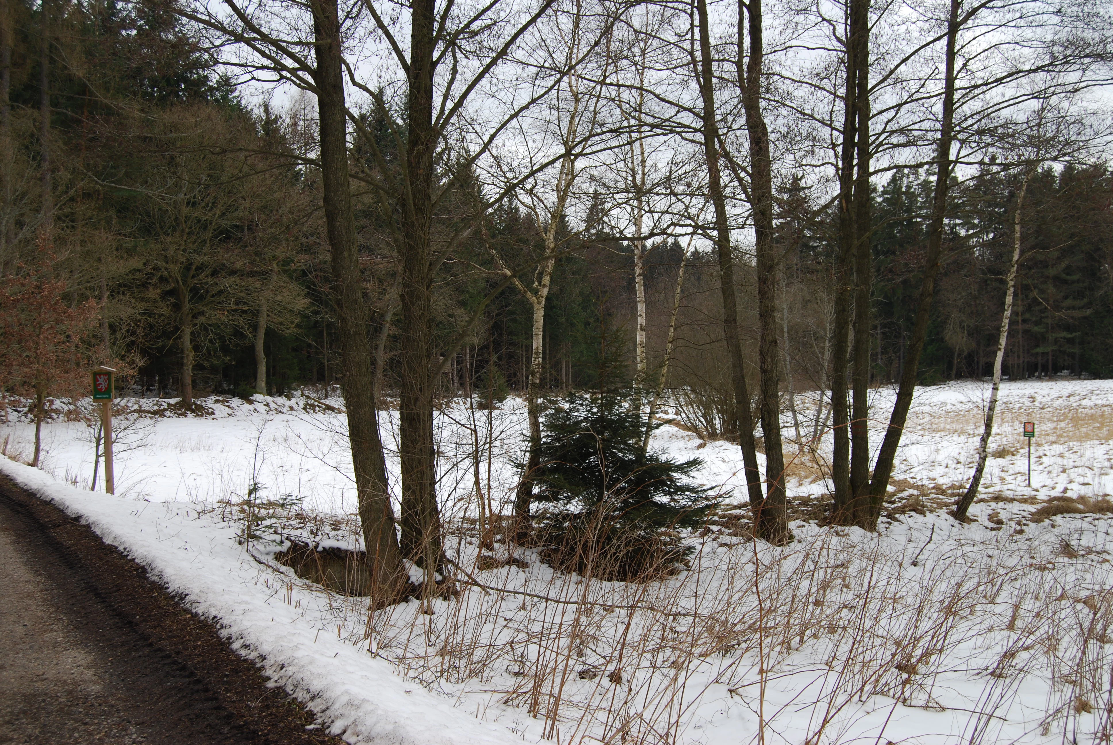
A snowy meadow bordered by trees and forest in the Czech Republic, viewed from a roadside edge.
A snow covered meadow in the Malý Kosatín natural monument.

Malý Kosatín ecosystems, habitats, and plant life

The ecological heart of Malý Kosatín is a permanently moist fen meadow whose vegetation has been classified within the Calthion alliance, an alliance typical of damp, nutrient-rich meadows rich in flowering herbs, with elements of the Caricion fuscae and Molinion alliances that bring in short-sedge communities and more species-rich, intermittently wet meadow types. Approximately ninety percent of the protected area is covered by this vegetation mosaic, the rest being occupied by small reed patches and transitional zones along the edges and near the stream.

The plant community is unusually rich for so small a site and reflects a habitat maintained by long-term mowing without heavy fertilization. The May orchid (Dactylorhiza majalis) dominates the botanical importance, with populations reported at up to around four hundred flowering individuals, making the site one of the most important orchid localities in the region. A second key species is the strongly threatened marsh grass-of-Parnassus (Parnassia palustris), present in tens of individuals. Eight species of sedges have been recorded, including the very rare Davall's sedge (Carex davalliana), along with narrow-leaved and broad-leaved cotton grasses (Eriophorum angustifolium and E. latifolium), the globeflower Trollius altissimus, marsh thistle indicators, common marsh marigold (Caltha palustris), purple loosestrife (Lythrum salicaria relative wet-meadow species), great burnet (Sanguisorba officinalis), and a range of other moisture-loving herbs making up a colorful late-spring and summer meadow.

Across the central part of the meadow, sedge tussocks and smaller rush patches provide structure and moisture gradients. To the north, common reed (Phragmites australis) has been gradually expanding from the upper edge of the site, a phenomenon driven by changes in surrounding land use and abandonment of traditional mowing on adjacent plots, and a primary concern for current management. The stream valley margin adds slightly different microhabitats where reed, sedges, and herbaceous marsh plants intermix, contributing to the overall diversity of the area.
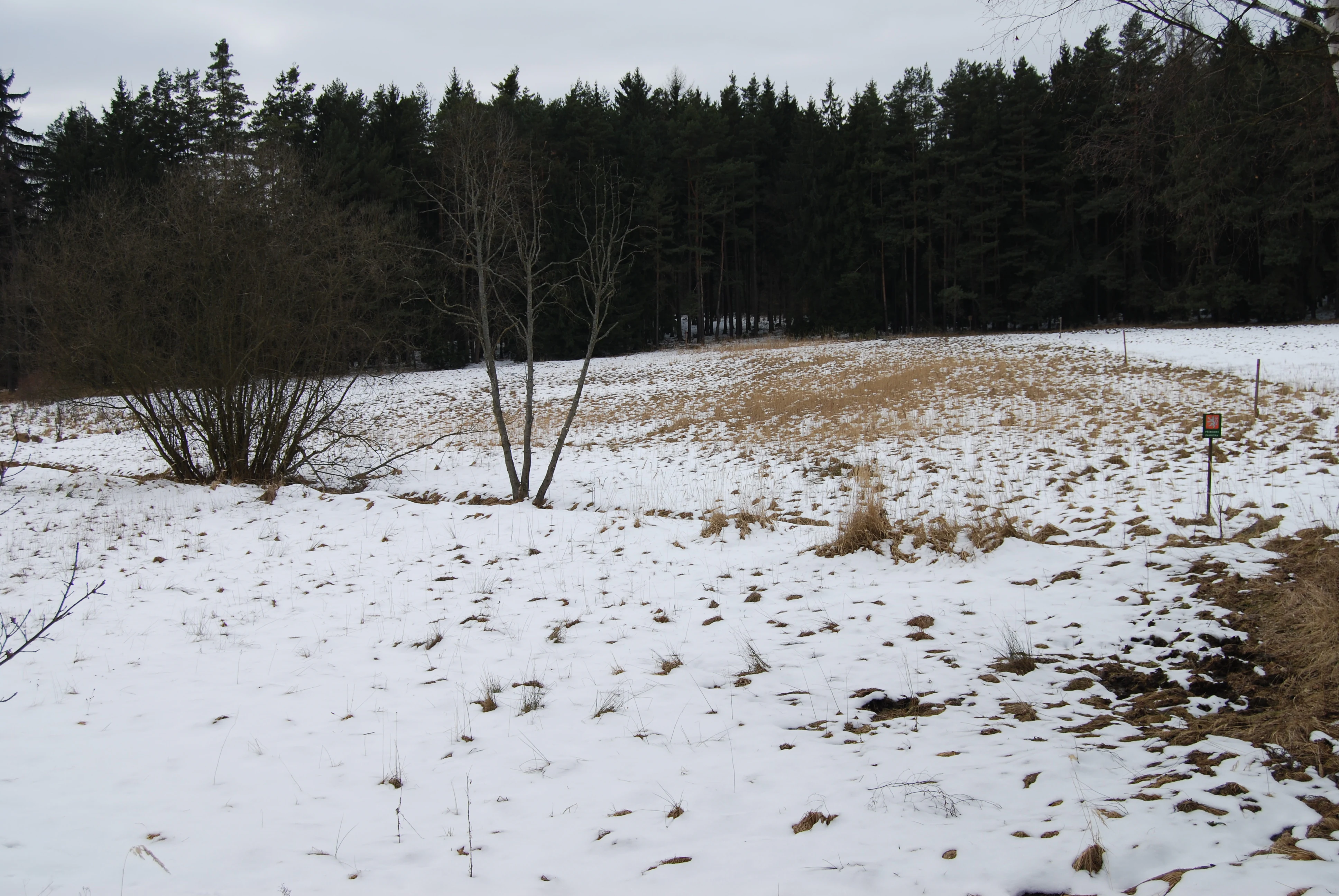
A wide, snowy field leads toward a dense treeline of evergreen trees under an overcast sky.
A snow-covered meadow in the Malý Kosatín natural monument.

Malý Kosatín wildlife and species highlights

No specifically protected animal species have been formally recorded at Malý Kosatín, but the meadow nevertheless supports a rich community of typical meadow invertebrates and small invertebrates associated with wetlands. Ground beetles of the group sometimes called střevlíčci have been documented here, including species such as Pterostichus diligens, while rove beetles of the family Staphylinidae include species like Encephalus complicans, Euaestethus ruficapillus, and Ochthephilum fracticorne. Among true bugs, the small shore bug Hebrus pusillus, characteristic of boggy margins, has been observed, and the dichromatic spider Micrommata roseum has been recorded in the meadow.

In addition, a conspicuous short-winged fly, Elachiptera brevipennis, has been documented, and the warm-loving land snail Alinda biplicata has been observed on the site. Although none of these is a formally protected species, together they indicate the meadow's value as a refuge for meadow and wetland invertebrate communities that have become rarer as intensively managed farmland has replaced traditional hay meadows across much of Bohemia. Regular mowing plays an indirect but important role in maintaining these insect communities, since it preserves the open, flower-rich vegetation structure on which they depend.

Malý Kosatín conservation status and protection priorities

Malý Kosatín's conservation value lies in the preservation of a small, traditionally managed wet meadow and its associated plant community within a region where such habitats have dramatically declined. The site's classification as a přírodní památka (natural monument) under Czech law and as an IUCN Category IV species management area reflects the priority given to maintaining the population of Dactylorhiza majalis and Parnassia palustris, both of which are declining across central Europe. The site's dependence on continuing mowing makes it a textbook example of how active management, not just fencing, is essential to conserving open meadow biodiversity.

The principal current threats are expansion of common reed (Phragmites australis) from the northern edge, which if unchecked forms a dense, shading canopy nearly two meters tall and can occupy almost half of the protected area, along with ruderalization across roughly ten percent of the site, where species such as Carex brizoides and stinging nettle (Urtica dioica) encroach from disturbed edges, the stream, and the road. A further concern is the spread of bush grass (Calamagrostis epigeios) into the meadow from a nearby clear-cut.

To counter these threats, the management plan calls for repeated mowing of the reed-dominated parts, ideally twice per year including an early July cut with a brushcutter at around 30 cm height, along with the established late-summer mowing of the main meadow documented since 2005. The careful documentation of increasing flowering in Parnassia palustris under this regime is itself an argument for continuity of traditional meadow management and a model for similar small protected grasslands elsewhere in Bohemia.

Malý Kosatín cultural meaning and human context

The cultural significance of Malý Kosatín is closely tied to the rural heritage of the Písek District and to the long continuity of traditional hay-making that shaped the Bohemian countryside. Surveys from the 1990s captured the image of an elderly couple from Boudy personally maintaining the meadow with hand tools, contrasting with the mechanized management of neighboring fields, illustrating a moment of transition between two eras of land care.

The site also sits near the Alšova naučná stezka educational trail linking Mirotice and Čimelice, named after the painter Mikoláš Aleš, and a short distance from the Kosatínský viklan, a striking glacial erratic that has its own cultural and geological significance. Although the reserve itself is not open to the public, this combination of natural monument, educational trail, and nearby geological landmark gives the area a layered identity combining botany, geological heritage, and the rural traditions of southern Bohemia.

Top sights and standout views in Malý Kosatín

At the heart of Malý Kosatín lies a phenomenon far more impressive than its size would suggest: within a single fraction of a hectare, several hundred May orchids (Dactylorhiza majalis) flower alongside a strong population of the strongly threatened Parnassia palustris, supported by a mosaic of Calthion, Caricion fuscae, and Molinion meadow communities. Eight sedge species and both narrow- and broad-leaved cotton grasses contribute to a community of exceptional botanical density.

Equally notable is the site's role as a working example of active meadow conservation. Regular mowing, careful reed control, and a formalized management plan have preserved both rare plants and a rich invertebrate community. Set against the backdrop of the wooded hills Velký Kosatín and Malý Kosatín, and integrated into the landscape through the nearby Alšova naučná stezka and the Kosatínský viklan erratic, the site captures the harmony of geology, traditional land use, and species-rich grassland that defines much of the Bohemian countryside.

Best time to visit Malý Kosatín

Although the reserve itself is not publicly accessible, the surrounding area and the nearby educational trail can be appreciated year-round. The most rewarding period for understanding Malý Kosatín's botanical character would be late spring and early summer, when the May orchid (Dactylorhiza majalis) reaches its flowering peak in the South Bohemian climate, followed by a colorful succession of fen-meadow blooms through midsummer. Late summer is also when the regular conservation mowing is carried out, a moment when management, rather than visitor access, becomes the visible face of the site.

In winter, the bare meadow framed by forest offers a quieter view of the site's topography and its slope above the Kostarecký potok, with no flowering display but a clear sense of how small-scale, traditional land use continues to preserve a distinctive Bohemian landscape.


Monthly climate preview

Long-term representative coordinate measurements detailing monthly temperature ranges and precipitation

Malý Kosatín Climate Normals, Annual Temperature and Precipitation Rhythm

Historical climatology data captures measured monthly temperature swings and precipitation rates across a representative coordinate at 526 meters of elevation in Malý Kosatín. Reviewing the complete twelve-month profile provides deeper analytical context regarding sustained thermal fluctuations and precipitation patterns over time.
Annual mean8 °C
-3 °C19 °C
Jan-3°
Feb-2°
Mar
Apr
May12°
Jun16°
Jul19°
Aug18°
Sep13°
Oct
Nov
Dec-2°
Warmest month
July

18.5 °C

Coolest month
January

-2.8 °C

Wettest month
June

2.9 mm/day

Driest month
February

1.4 mm/day

Park location guide

Geography guide, regional context, and park location map for Malý Kosatín

Malý Kosatín park geography, regions, and map view in Czechia

Understand where Malý Kosatín sits in Czechia through a broader geographic reading of the surrounding landscape, nearby location context, and its mapped position within the national park landscape.

How Malý Kosatín fits into Czechia

Czech Republic is a landlocked Central European country with a population of approximately 10.9 million people. The nation was established as an independent state on January 1, 1993, following the dissolution of Czechoslovakia. Its capital and largest city is Prague, with other major urban centers including Brno, Ostrava, Plzeň, and Liberec.

Wider geography shaping Malý Kosatín in Czechia

The Czech Republic is a landlocked country in Central Europe. It is bordered by Germany to the west, Austria to the south, Poland to the northeast, and Slovakia to the southeast. The landscape is predominantly hilly, with the territory covering 78,871 square kilometers.

Map view of Malý Kosatín

Use this park location map to pinpoint Malý Kosatín in Czechia, understand its exact geographic position, and read its mapped placement within the surrounding landscape more clearly.

Pigeon | © OpenStreetMap contributors

Location context for Malý Kosatín

Jihočeský kraj

Visual exploration of wet meadow habitats, forest edges, and South Bohemian terrain.

Malý Kosatín Photos and Protected Landscape Scenery

Photographic records capture the distinct vegetation, delicate fen habitats, and protected character of Malý Kosatín within its wooded upland setting. Visual documentation reveals the subtle terrain, rare botanical communities, and natural surroundings that define this South Bohemian protected site.

A large moss-covered boulder precariously balanced on a smaller stone base in a forest setting.

A wooden information sign and a small shield displaying the Czech national emblem stand in a grassy meadow bordered by a pine forest.

A snowy meadow bordered by trees and forest in the Czech Republic, viewed from a roadside edge.

A wide, snowy field leads toward a dense treeline of evergreen trees under an overcast sky.

Park atlas

Compare adjacent wetland habitats, wooded hills, and regional conservation landscapes

Other Parks and Protected Areas Near Malý Kosatín in the South Bohemian Countryside

Continue exploring regional protected landscapes by comparing Malý Kosatín with other nearby natural monuments and woodland reserves across South Bohemia. Examining adjacent habitats provides deeper context into traditional grassland management and local upland terrain.
Natural monumentJihočeský kraj
About 9.3 km away#1 closest

Southeast

V Obouch Natural Monument: Geographic Profile of the Lomnice River Valley

Protected riparian corridors and riverine terrain in Jihočeský kraj

Explore the unique geomorphology of V Obouch, a protected river segment in the Czech Republic. This site provides a detailed cross-section of alder floodplain forests, boulder rapids, and canyon-like terrain that defines the ecological character of the South Bohemian river network.

Area
0.051 km²
Established
1986
IUCN
IV
Relief
Upland
A wide watercolor illustration showing a pale landscape with a stream, rocky banks, distant hills, and pink and green grass in the foreground.
Natural monumentJihočeský kraj
About 13 km away#2 closest

South

Michovka Natural Monument: Protected Limestone Landscapes in the South Bohemian Region

A diverse protected area in the Písek District of the Czech Republic.

Located on the outskirts of Brloh u Drhovle, Michovka encompasses a distinctive mix of fishponds, limestone-rich rocky slopes, and rare short-sedge vegetation. This compact protected area provides a vital habitat for endangered wildlife and represents an important segment of the South Bohemian natural terrain.

Area
0.025 km²
Established
1985
IUCN
IV
Relief
Lowland
A watercolor painting showing a panoramic view of soft rolling green hills, a small stream, and wildflowers in the foreground.
Natural monumentJihočeský kraj
About 16 km away#3 closest

West

Smyslov Natural Monument: Mapping Protected Habitats in the South Bohemian Region

Traditional pastoral landscapes and botanical meadow mosaics

Smyslov stands as a significant natural monument in the Jihočeský kraj, illustrating the traditional ecological structure of the Blatná area. The site is defined by its tight combination of dry, rocky slopes featuring juniper, and shallow depressions hosting moisture-loving vegetation. Explore this distinct protected area to understand its role in conserving rare meadow flora and traditional South Bohemian terrain.

Area
0.078 km²
Established
1990
IUCN
IV
Relief
Lowland
A horizontal watercolor painting depicting a soft green landscape with scattered trees, rolling hills, and a pale pink sky on a white background.
Natural monumentJihočeský kraj
About 17 km away#4 closest

East

Sobědražský Prales Natural Monument: Protected Woodland Map and Geographic Context

An ancient oak and beech forest remnant in the South Bohemian Region.

Sobědražský prales represents a significant natural monument within the Czech Republic, protecting a rare stand of aged oaks and beeches. This site offers valuable insights into the historical composition of local forests, supporting critical biodiversity such as hole-nesting birds amidst the managed landscapes of the Jihočeský kraj.

Area
0.017 km²
Established
1986
IUCN
IV
Relief
Upland
Natural monumentJihočeský kraj
About 20 km away#5 closest

South

Velký Potočný: Protected Natural Monument and Wetland Geography in the South Bohemian Region

An essential migratory node and rare plant refuge in the Czech landscape.

Velký Potočný represents a unique intersection of traditional fishpond management and modern biodiversity conservation in Jihočeský kraj. This natural monument supports exceptional shoreline vegetation, including rare species like Cyperus fuscus, and serves as a critical breeding and stopover ground for diverse waterbirds. Its shallow basin geography and hydrologic connection to the Otava River make it a vital point of interest for understanding the ecological function of South Bohemia's inland wetland network.

Area
0.39 km²
Established
1986
IUCN
IV
Relief
Lowland
A minimalist watercolor illustration depicting a soft, light-toned landscape with a row of trees on the right and distant, blurred hills in the background.
Natural monumentJihočeský kraj
About 21 km away#6 closest

East

Rukávečská obora: Natural Monument and Protected Beech Forest in Jihočeský kraj

A historic protected landscape in the Písek Highlands

Located in the Czech Republic, Rukávečská obora represents a significant natural monument defined by its 225-year-old beech stands. This site provides an essential look at the geological and botanical history of the Písek Highlands, serving as a key protected area for local invertebrate and bird species within the Vltava river valley watershed.

Area
0.067 km²
Established
1929
IUCN
V
Relief
Upland
A watercolor painting of soft green rolling hills and small clusters of pine trees against a light sunset sky.
Natural monumentJihočeský kraj
About 21 km away#7 closest

Southwest

Ryšovy Natural Monument and Botanical Protected Area in Jihočeský kraj

Exploring limestone woodland terrain and rare floral habitats

Ryšovy is a notable natural monument in the Czech Republic, defined by its characteristic limestone bedrock and the resulting diverse herb layer. This protected area creates a significant botanical stronghold within the wider landscape of the Jihočeský kraj, featuring a mosaic of woodland patches and sun-exposed clearings that support protected orchids and other rare thermophilous plant species.

Area
0.35 km²
Established
1990
IUCN
IV
Relief
Upland
A watercolor painting showing a panoramic view of a marshy wetland area with sparse bare trees, grassy mounds, and rolling hills in the background.
Natural monumentJihočeský kraj
About 23 km away#8 closest

South

Ražický rybník Natural Monument and Protected Wetland Geography in South Bohemia

Protected pond ecosystems and riparian terrain maps

Ražický rybník is a protected natural monument located in the Písek District of the Czech Republic, encompassing a shallow fishpond and surrounding meadows. This site serves as an essential breeding ground for waterbirds and provides a detailed look at the wetland mosaic characteristic of the Otava river lowlands. The area highlights the intersection of long-standing conservation efforts and habitat restoration through its diverse aquatic microhabitats.

Area
0.291 km²
Established
1986
IUCN
IV
Relief
Lowland

Common questions about visiting, size, designation, and location context for Malý Kosatín

Malý Kosatín FAQs for park facts, access, geography, and protected area context

Find quick answers about Malý Kosatín, including protected-area facts, park geography, trail and visitor context, and how the park fits into its surrounding country and regional landscape.
MoriAtlas Explorer

Continue Your Protected Areas Search Across the Global Atlas

Deepen your exploration by continuing the structured search for national parks and protected areas worldwide. Utilize the comprehensive filtering capabilities to compare different conservation landscapes and refine your understanding of global park geography. Discover more about the distribution and characteristics of protected natural areas.

Global natural geography