Mori Atlas logo
Natural monumentVelký Potočný

A critical migratory stopover and specialist wetland habitat within the South Bohemian pond landscape.

Velký Potočný Natural Monument: Mapped Geography and Protected Wetland Boundaries in Jihočeský kraj

(Přírodní památka Velký Potočný)

Velký Potočný is a significant natural monument situated in the Písek district of the Czech Republic, serving as a vital sanctuary for rare plant species and diverse waterbird communities. This protected landscape is defined by its traditional managed fishpond environment and seasonal drawdown zones, which create specialized muddy sediment habitats. The site sits at the intersection of the České Budějovice Basin and the Táborská pahorkatina, functioning as a key ecological node connected by the Brložský potok to the Otava River catchment.

fishpondwetlanddrawdown zonereedbedwaterbirdsmigratory stopover

Velký Potočný

Natural monument

Park overview

Structured park overview, official facts, and landscape profile for Velky Potočný Natural Monument

Velky Potočný Natural Monument park facts, protected area profile, and essential visitor context

Review the core facts for Velky Potočný Natural Monument, including designation, size, terrain, visitor scale, habitats, and operating context in one park-focused overview.

About Velky Potočný Natural Monument

Velky Potočný is a focused, species-driven protected area in the South Bohemian countryside, centered on a single fishpond whose exposed shorelines and reedy margins host a striking concentration of rare plants and waterbirds. Declared in 1986, the natural monument brings formal conservation status to a working element of the South Bohemian pond landscape, and it illustrates how a relatively small site can carry outsized ecological value when its traditional management continues.

The site sits at the meeting point of two distinct geomorphological units: the České Budějovice Basin, in its Putim basin and Kestřany basin subunits, and the Táborská pahorkatina (Tábor Upland), represented locally by the Písecká pahorkatina and its Zvíkov podcelek. The result is a gently undulating lowland setting, with the pond occupying a shallow depression that is regularly regulated by the Brložský potok, itself a left-bank tributary of the Otava River. Elevation across the protected area lies between roughly 378 and 380 meters above sea level, placing it squarely within the warm, dry lowland character that defines much of the Českobudějovická pánev.

As a fishpond-protected site, Velky Potočný sits within one of Europe's most distinctive cultural landscapes: a centuries-old network of artificial waterbodies created for carp production and now functioning as a major stronghold for wetland biodiversity. The site's IUCN category IV designation as a Habitat/Species Management Area underlines this narrow focus on maintaining specific habitat conditions rather than protecting a large-scale wilderness.

The natural monument is small in area, around 38.95 hectares, but it combines shoreline habitat, open water, reedbeds, and adjacent wet meadows to deliver an unusually complete microcosm of lowland pond ecology. That compactness, paired with careful protection of its drawdown dynamics, gives Velky Potočný a clear identity within the broader South Bohemian pond system.

Quick facts and research context for Velky Potočný Natural Monument

Velky Potočný is a Czech natural monument (přírodní památka) in category IV of the IUCN system, designated to protect a single habitat-type feature: a managed fishpond and its associated species. The site was first declared on 1 February 1986 by the then Okresní národní výbor Písek and is now administered by the Regional Authority of the South Bohemian Region (Jihočeský kraj).

The protected area covers roughly 39 hectares, with an additional small protective buffer, and is situated in the cadastral territory of Staré Kestřany, about one kilometer from the village. Its purpose is narrowly focused: maintaining the hydrological and ecological conditions that allow rare plants on exposed pond margins and characteristic waterbirds to persist in a working fishpond landscape.

Protection and recognition

Documented terrestrial boundaries, management scope, and conservation oversight records

Velký Potočný Protection Status and International Recognition

Velký Potočný maintains a documented terrestrial protection scope without imported international recognition sources or transboundary borders. Comprehensive conservation records outline official designation frameworks, baseline management details, and administrative oversight.

Protection details

Protection scope
Terrestrial
Transboundary protection
No
Buffer area
0.03 km²
Park context

Deeper park guide and search-rich context for Velky Potočný Natural Monument

Velky Potočný Natural Monument history, landscape, wildlife, and travel context

Explore Velky Potočný Natural Monument through its history, landscape character, ecosystems, wildlife, conservation priorities, cultural context, and seasonal travel timing in a structured park guide built for atlas discovery and search intent.

Why Velky Potočný Natural Monument stands out

Velky Potočný is best known as a refuge for rare shore-zone plants such as Cyperus fuscus, Isolepis setacea, and Carex bohemica, which thrive on the muddy sediments exposed when the fishpond is drawn down for traditional management. Equally distinctive is its rich waterbird community, including breeding populations of great crested grebe, black-necked grebe, and little grebe, alongside water rail, great reed warbler, marsh harrier, and golden oriole. The pond's role as a migratory stopover in the wider South Bohemian pond network gives the small site disproportionate ecological importance.
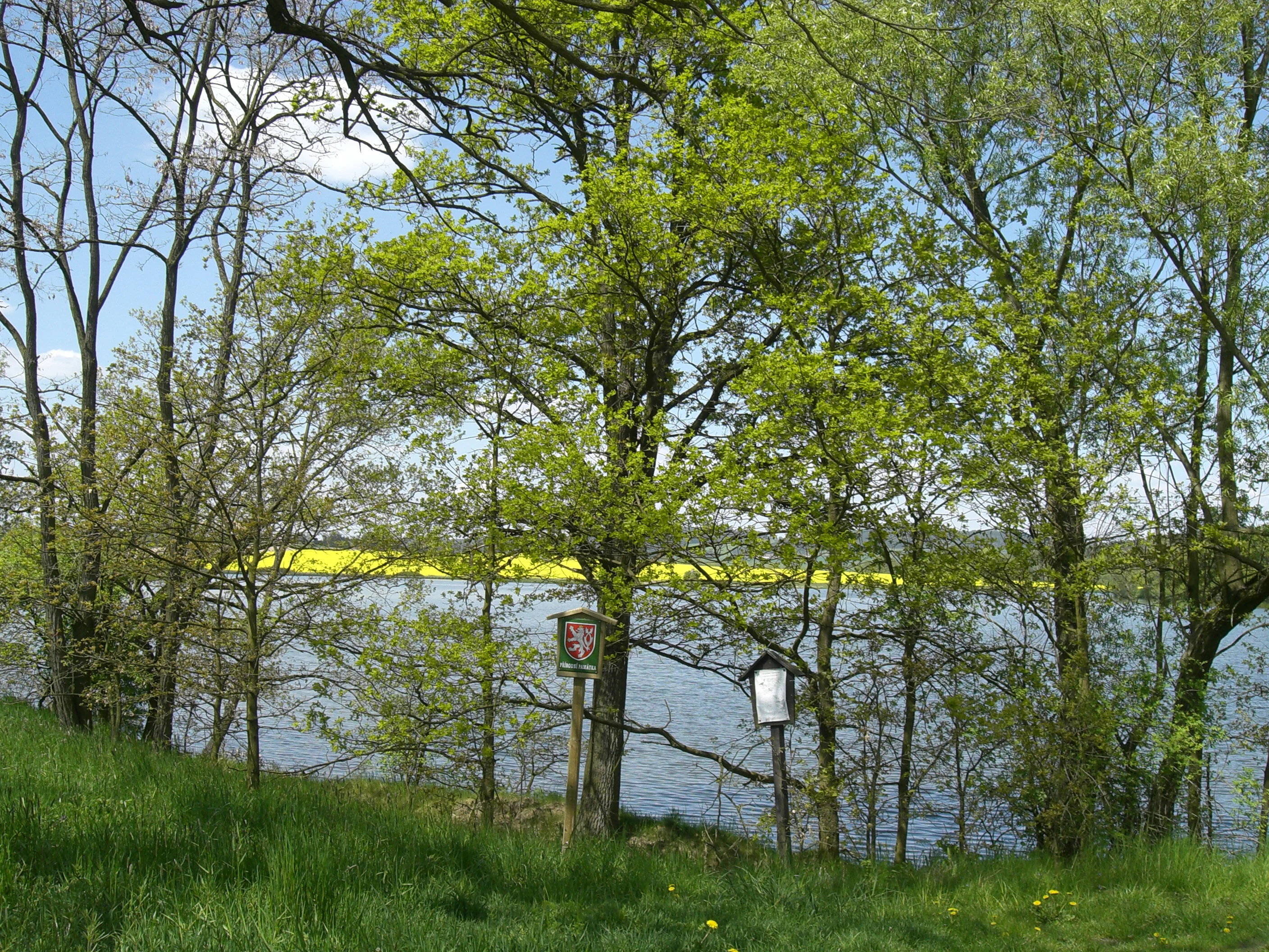
A peaceful lake or pond surrounded by trees with lush green foliage, featuring official protected area signage on wooden posts in the foreground and a field of yellow flowers in the distance.
A view of the Velký Potočný pond and protected natural area in the South Bohemian Region.

Velky Potočný Natural Monument history and protected-area timeline

Velky Potočný was declared as a přírodní památka on 1 February 1986 by the former Okresní národní výbor Písek, the district national committee that handled protected-area designations in the pre-1990 administrative system. The decision was driven by the ecological significance of the Velký potočný rybník, a managed fishpond whose seasonal drawdown zones supported rare plants and a rich waterbird community unusual for such a small area.

Following the restructuring of Czech protected-area administration, management responsibility for the site transferred to the Regional Authority of the South Bohemian Region. The site's character is closely tied to the long history of fishpond management in South Bohemia, where artificial waterbodies have been maintained for centuries; Velky Potočný represents a case where that traditional land use was formally recognized as an asset for biodiversity conservation rather than seen as conflicting with it.

The natural monument has since been referenced in regional inventories of protected areas in the Českobudějovice region and in encyclopedic works covering Czech and Moravian water bodies, helping to consolidate its profile as a small but ecologically meaningful fishpond sanctuary.

Velky Potočný Natural Monument landscape and geographic character

The landscape of Velky Potočný is a low-energy, low-elevation scene typical of South Bohemia's pond belt. The protected area lies between roughly 378 and 380 meters above sea level, occupying a shallow basin where the contours of the land barely rise above the surrounding meadows and fields.

Geomorphologically, the site straddles the edge of the České Budějovice Basin and the Táborská pahorkatina, with the northern edge of the pond reaching into the Zvíkovská pahorkatina subunit of the Písecká pahorkatina. This transitional position gives the area the gently undulating character of a basin's flank, interrupted by the broad, flat mirror of the fishpond itself.

The pond is the dominant landscape element, surrounded by reedbeds, wet meadows, and narrow belts of woody growth typical of Czech pond margins. Through it flows the Brložský potok, a small watercourse that connects the pond hydrologically to the Otava River system, ensuring the regular seasonal fluctuation in water level that shapes the site's most distinctive habitats.

Velky Potočný Natural Monument ecosystems, habitats, and plant life

The ecological identity of Velky Potočný is built around the cyclical exposure of the pond's shoreline. As water levels fall during traditional fishpond management, the freshly exposed muddy sediments create a habitat for a distinctive community of short-lived, disturbance-dependent plants. These drawdown zones are the core reason the site was given formal protection.

Surrounding the open water, reedbeds and wet meadow fringes extend the ecological gradient from aquatic to terrestrial conditions, supporting amphibians and a structured bird community. The juxtaposition of open water, emergent vegetation, and exposed sediment within a single compact site gives the natural monument a habitat diversity that is unusual for its size and forms the basis of its conservation value.

Velky Potočný Natural Monument wildlife and species highlights

Wildlife at Velky Potočný is dominated by birds, reflecting the site's character as a working fishpond with extensive reed and open-water habitats. The pond hosts breeding grebes, including great crested grebe, black-necked grebe, and little grebe, alongside water rail hidden in the reedbeds and great reed warbler singing from the emergent vegetation.

Raptors such as marsh harrier hunt over the reed fringes, while golden oriole and red-backed shrike occupy the wooded margins close to the water. Eagle owl, one of the largest owls in the region, has also been recorded at the site, adding a notable presence of large nocturnal predator.

The pond is documented as an important migratory stopover, with waterbirds using the open water and fringing habitats during seasonal passages, amplifying its conservation significance beyond the breeding season. Amphibians are also present, including pool frog among the typical pond-edge fauna.

Velky Potočný Natural Monument conservation status and protection priorities

Velky Potočný is classified as IUCN category IV, a Habitat/Species Management Area, signaling that its primary purpose is to maintain the specific conditions required by a particular set of species rather than to safeguard a broad landscape. The Czech system's přírodní památka designation reflects that narrower focus on a single biologically valuable feature: the Velký potočný rybník itself.

The site's conservation value depends on maintaining the traditional pond management regime that creates exposed sediments and shallow water zones. Without that cycle, the rare drawdown-specialist plants and the waterbird communities built around varied water depths would not persist. The declaration of a protective buffer around the site, alongside the core protected area, supports this by limiting damaging changes in the immediate surroundings.

Within the South Bohemian pond network, Velky Potočný contributes a small but well-defined refuge where rare flora and characteristic fauna can survive in a landscape otherwise dominated by agriculture and aquaculture.

Top sights and standout views in Velky Potočný Natural Monument

The natural monument's standout qualities sit at the intersection of a traditional South Bohemian fishpond and a concentration of rare wetland species. Its drawdown zones, which support specialist plants such as Cyperus fuscus, Isolepis setacea, and Carex bohemica, set the site apart at a regional scale and are the primary reason for its formal protection.

The pond's dense waterbird community, spanning grebes, rails, warblers, raptors, and even eagle owl, brings additional recognition, especially because the site doubles as a migratory stopover. Together, these traits make Velky Potočný a compact but ecological-dense showcase of how centuries-old fishpond culture can be reconciled with modern biodiversity conservation.

Best time to visit Velky Potočný Natural Monument

The character of Velky Potočný changes meaningfully with the seasons because of the fishpond's managed water levels. Late summer and early autumn, when traditional drawdown begins to expose pond-bottom sediments, are typically the most interesting periods for observing rare shore plants and the waders and waterbirds drawn to the freshly opened habitat.

Spring and early summer bring active breeding bird display, with reedbed songbirds and grebes most conspicuous around the margins. Migration periods, in spring and again in autumn, offer the best chance to see species using the site as a stopover, while winter can bring quieter open water and concentrations of hardy waterfowl in milder spells. A natural surface water level and minimal disturbance, rather than any logistical constraint, are the main factors to consider when planning a visit.

Monthly climate preview

Long-term monthly temperature averages and precipitation records for Jihočeský kraj terrain

Velký Potočný Climate Normals and Measured Annual Temperature Patterns

Representative coordinate measurements trace twelve-month temperature variations and precipitation distributions across the protected landscape. Examining complete monthly climate profiles reveals detailed long-term averages for thermal rhythms and precipitation metrics.
Annual mean8 °C
-3 °C19 °C
Jan-3°
Feb-1°
Mar
Apr
May13°
Jun17°
Jul19°
Aug19°
Sep14°
Oct
Nov
Dec-2°
Warmest month
July

18.9 °C

Coolest month
January

-2.7 °C

Wettest month
June

2.8 mm/day

Driest month
February

1.2 mm/day

Park location guide

Geography guide, regional context, and park location map for Velky Potočný Natural Monument

Velky Potočný Natural Monument park geography, regions, and map view in Czechia

Understand where Velky Potočný Natural Monument sits in Czechia through a broader geographic reading of the surrounding landscape, nearby location context, and its mapped position within the national park landscape.

How Velky Potočný Natural Monument fits into Czechia

Czech Republic is a landlocked Central European country with a population of approximately 10.9 million people. The nation was established as an independent state on January 1, 1993, following the dissolution of Czechoslovakia. Its capital and largest city is Prague, with other major urban centers including Brno, Ostrava, Plzeň, and Liberec.

Wider geography shaping Velky Potočný Natural Monument in Czechia

The Czech Republic is a landlocked country in Central Europe. It is bordered by Germany to the west, Austria to the south, Poland to the northeast, and Slovakia to the southeast. The landscape is predominantly hilly, with the territory covering 78,871 square kilometers.

Map view of Velky Potočný Natural Monument

Use this park location map to pinpoint Velky Potočný Natural Monument in Czechia, understand its exact geographic position, and read its mapped placement within the surrounding landscape more clearly.

Pigeon | © OpenStreetMap contributors

Location context for Velky Potočný Natural Monument

Jihočeský kraj

Explore the terrain, shorelines, and seasonal drawdown zones defining this protected South Bohemian wetland.

Velký Potočný Photos and Landscape Scenery: Visualizing the Protected Fishpond Habitat

Visual documentation reveals the low-elevation basin topography and traditional fishpond character defining Velký Potočný. Examining detailed habitat photographs helps researchers interpret shoreline ecology, wetland vegetation, and waterbird distribution across the protected landscape.

A peaceful lake or pond surrounded by trees with lush green foliage, featuring official protected area signage on wooden posts in the foreground and a field of yellow flowers in the distance.

Park atlas

Compare adjacent wetland reserves and lowland pond ecosystems across South Bohemia

Exploring Parks Near Velký Potočný and Surrounding Protected Wetland Landscapes

Visitors exploring Velký Potočný can browse related protected areas across the surrounding lowland basin and river valleys. Comparing adjacent wetland habitats reveals broader regional patterns in traditional fishpond management and migratory bird conservation.
A watercolor painting showing a panoramic view of a marshy wetland area with sparse bare trees, grassy mounds, and rolling hills in the background.
Natural monumentJihočeský kraj
About 4.5 km away#1 closest

Southeast

Ražický rybník Natural Monument and Protected Wetland Geography in South Bohemia

Protected pond ecosystems and riparian terrain maps

Ražický rybník is a protected natural monument located in the Písek District of the Czech Republic, encompassing a shallow fishpond and surrounding meadows. This site serves as an essential breeding ground for waterbirds and provides a detailed look at the wetland mosaic characteristic of the Otava river lowlands. The area highlights the intersection of long-standing conservation efforts and habitat restoration through its diverse aquatic microhabitats.

Area
0.291 km²
Established
1986
IUCN
IV
Relief
Lowland
A wide watercolor illustration showing a pale landscape with a stream, rocky banks, distant hills, and pink and green grass in the foreground.
Natural monumentJihočeský kraj
About 7.1 km away#2 closest

Northwest

Michovka Natural Monument: Protected Limestone Landscapes in the South Bohemian Region

A diverse protected area in the Písek District of the Czech Republic.

Located on the outskirts of Brloh u Drhovle, Michovka encompasses a distinctive mix of fishponds, limestone-rich rocky slopes, and rare short-sedge vegetation. This compact protected area provides a vital habitat for endangered wildlife and represents an important segment of the South Bohemian natural terrain.

Area
0.025 km²
Established
1985
IUCN
IV
Relief
Lowland
Watercolor painting of a tranquil pond scene with grassy shores, reeds, and rolling hills in the background under a soft sky.
Natural monumentJihočeský kraj
About 11 km away#3 closest

Southeast

Skalský rybník a Klokočínská olšina: Protected Wetland Landscapes and Forested Terrain

Natural Monument site in South Bohemia, Czech Republic

Located in the low-lying Českobudějovická pánev basin, this natural monument protects a tightly linked wetland system. The site encompasses open water, damp meadows, and broadleaf woodland, providing a refuge for protected waterbirds and rare pond-edge vegetation amidst the traditional landscape of South Bohemia.

Area
0.128 km²
Established
1986
IUCN
IV
Relief
Lowland
A watercolor painting of soft green rolling hills and small clusters of pine trees against a light sunset sky.
Natural monumentJihočeský kraj
About 12 km away#4 closest

West

Ryšovy Natural Monument and Botanical Protected Area in Jihočeský kraj

Exploring limestone woodland terrain and rare floral habitats

Ryšovy is a notable natural monument in the Czech Republic, defined by its characteristic limestone bedrock and the resulting diverse herb layer. This protected area creates a significant botanical stronghold within the wider landscape of the Jihočeský kraj, featuring a mosaic of woodland patches and sun-exposed clearings that support protected orchids and other rare thermophilous plant species.

Area
0.35 km²
Established
1990
IUCN
IV
Relief
Upland
Natural monumentJihočeský kraj
About 15 km away#5 closest

North

V Obouch Natural Monument: Geographic Profile of the Lomnice River Valley

Protected riparian corridors and riverine terrain in Jihočeský kraj

Explore the unique geomorphology of V Obouch, a protected river segment in the Czech Republic. This site provides a detailed cross-section of alder floodplain forests, boulder rapids, and canyon-like terrain that defines the ecological character of the South Bohemian river network.

Area
0.051 km²
Established
1986
IUCN
IV
Relief
Upland
Watercolor painting of a soft, panoramic landscape with rolling green hills, a gentle path or stream, and misty mountain silhouettes in the background under a pale sky.
Natural monumentStrakonice District
About 20 km away#6 closest

Southwest

Na Opukách Natural Monument: Protected Calcareous Landscapes in Strakonice District

Botanical richness and geological geography of a unique Bohemian hilltop reserve

Na Opukách protects a specialized environment of dry grassland and opuka outcrops that remain rare within the wider Strakonice foothills. This site provides a focused look at how specific sedimentary geology supports diverse orchid populations and hardy meadow flora within a predominantly forested regional geography.

Area
0.348 km²
Established
1996
IUCN
IV
Relief
Upland
A pale, soft watercolor painting of a rolling, grassy meadow landscape with a prominent green mushroom in the foreground and sparse, leafless trees.
Natural monumentJihočeský kraj
About 20 km away#7 closest

North

Malý Kosatín: Protected Botanical Landscapes in the South Bohemian Region of Czechia

A rare fen-meadow sanctuary in the Písek District

Located in the heart of the Czech countryside, Malý Kosatín is a natural monument distinguished by its intense botanical density and traditional meadow management. The site serves as a crucial habitat for threatened orchids and sedge communities, providing a focused view of the ecological character that defines the upland terrain surrounding the Písek District.

Area
0.01 km²
Established
1986
IUCN
IV
Relief
Upland
A minimalist watercolor illustration depicting a soft, light-toned landscape with a row of trees on the right and distant, blurred hills in the background.
Natural monumentJihočeský kraj
About 23 km away#8 closest

Northeast

Rukávečská obora: Natural Monument and Protected Beech Forest in Jihočeský kraj

A historic protected landscape in the Písek Highlands

Located in the Czech Republic, Rukávečská obora represents a significant natural monument defined by its 225-year-old beech stands. This site provides an essential look at the geological and botanical history of the Písek Highlands, serving as a key protected area for local invertebrate and bird species within the Vltava river valley watershed.

Area
0.067 km²
Established
1929
IUCN
V
Relief
Upland

Common questions about visiting, size, designation, and location context for Velky Potočný Natural Monument

Velky Potočný Natural Monument FAQs for park facts, access, geography, and protected area context

Find quick answers about Velky Potočný Natural Monument, including protected-area facts, park geography, trail and visitor context, and how the park fits into its surrounding country and regional landscape.
MoriAtlas Explorer

Continue Your Protected Areas Search Across the Global Atlas

Deepen your exploration by continuing the structured search for national parks and protected areas worldwide. Utilize the comprehensive filtering capabilities to compare different conservation landscapes and refine your understanding of global park geography. Discover more about the distribution and characteristics of protected natural areas.

Global natural geography