Mori Atlas logo
National parkMarahoué National Park

Analyzing the shifting geography and terrain between forest remnants and savanna ecosystems

Marahoué National Park: A Study of Protected Landscapes and Ecological Transition in Ivory Coast

(Parc National de la Marahoué)

Marahoué National Park represents a significant protected area within the Sassandra-Marahoué District, showcasing the complex transition between dense interior forests and wooded savanna zones. This geographic analysis examines the terrain characterized by low hills and valleys along the Marahoué River, focusing on the remaining habitats and the ecological shifts that have defined this central Ivory Coast landmark. Discover the structural history of these protected lands and their ongoing relevance as a recorded site for significant bird diversity.

national parkIvory CoastWest AfricaImportant Bird Areasavannaforest remnants

Marahoué National Park

National park

Park overview

Structured park overview, official facts, and landscape profile for Marahoué National Park

Marahoué National Park park facts, protected area profile, and essential visitor context

Review the core facts for Marahoué National Park, including designation, size, terrain, visitor scale, habitats, and operating context in one park-focused overview.

About Marahoué National Park

Marahoué National Park represents both the ecological richness that West African protected areas once held and the severe conservation challenges facing the region. Located in the Sassandra-Marahoué District of central Ivory Coast, the park sits west of Bouaflé and covers approximately 1,010 square kilometers of terrain characterized by low hills and intervening valleys. The landscape originally featured a diverse mosaic of habitats with 60% dense forest, 15% secondary forest, 5% gallery forest along watercourses, and 17% savanna interspersed with woodland patches. The Marahoué River, flowing as a tributary to the larger Bandama River system, historically formed a natural eastern boundary for the protected area. The park sits at a critical ecological transition zone between the more heavily forested regions of Ivory Coast and the wooded savanna environments that characterize much of the country's interior. This positioning created a unique blend of forest and savanna species, making the area ecologically significant for West African biodiversity. However, decades of agricultural expansion, illegal logging, and ineffective protection have transformed this once-lush landscape into a fragmented environment where only remnant patches of secondary forest persist among agricultural lands and expanding savanna.

Quick facts and research context for Marahoué National Park

Marahoué National Park spans roughly 1,010 square kilometers in central Ivory Coast's Sassandra-Marahoué District, established in 1968. The landscape features low hills, valley systems, and sits at the ecological boundary between forest and savanna ecosystems. Originally supporting diverse habitats including dense forest, gallery forests, and savanna, the park has suffered severe deforestation with primary forest now entirely gone. The Marahoué River provides the eastern boundary, flowing into the Bandama River system. The park historically supported populations of West African chimpanzees, though none remain today, and hosts significant bird diversity recognized through Important Bird Area designation.

Protection and recognition

Terrestrial protected area framework and international recognition data

Marahoué National Park Protection Status and Conservation Recognition

Marahoué National Park maintains a documented terrestrial protection scope within the national conservation network. Structured conservation records outline established protected area parameters and international recognition status.

Protection details

Protection scope
Terrestrial
Transboundary protection
No
Park context

Deeper park guide and search-rich context for Marahoué National Park

Marahoué National Park history, landscape, wildlife, and travel context

Explore Marahoué National Park through its history, landscape character, ecosystems, wildlife, conservation priorities, cultural context, and seasonal travel timing in a structured park guide built for atlas discovery and search intent.

Why Marahoué National Park stands out

Marahoué National Park is best known for its dramatic ecological decline and its role as an Important Bird Area. Once a pristine forest sanctuary in central Ivory Coast, the park has lost nearly all its forest cover since the turn of the 21st century, with 93% of forest disappearing between 2003 and 2009. Despite this devastation, the park remains significant for bird conservation, hosting 287 recorded bird species including rarities like the emerald starling, black-headed bee-eater, and yellow-footed honeyguide. The park historically supported West African chimpanzees and diverse forest-dwelling mammals, though chimpanzee populations have been reduced to zero as habitat was destroyed.

Marahoué National Park history and protected-area timeline

Marahoué National Park was established in 1968, having previously functioned as a wildlife reserve. At its founding, the park covered 1,010 square kilometers and contained exceptional habitat diversity, with dense forest dominating approximately 60% of the area, secondary forest covering 15%, gallery forests along watercourses accounting for 5%, and savanna landscapes making up the remaining 17%. By 1975, just seven years after establishment, approximately 3% of the park had already been converted to cacao plantations and agricultural crops. Over the following decades, the park experienced persistent illegal logging and unauthorized settlement within its borders, with forest being systematically converted to agricultural land. No effective enforcement measures were implemented to prevent these encroachments, allowing the destruction to continue unchecked. By 2014, the primary forest that once covered the majority of the park had been entirely eliminated. Only 12% of secondary forest and 4% of gallery forest remained by this time, while 15% of the park had been converted to agricultural land and plantations. The remainder existed as savanna with scattered trees, a shadow of the diverse woodland environment that previously characterized the landscape.

Marahoué National Park landscape and geographic character

The landscape of Marahoué National Park consists of low hills with intervening valleys, creating a gently undulating terrain across central Ivory Coast. The park occupies a transitional ecological zone between the more heavily forested areas of the country's interior and the wooded savanna that dominates much of the region. Originally, the park contained a diverse patchwork of habitats including gallery forests along watercourses, dense primary forest blocks, secondary forest regrowth, and savanna grasslands interspersed with woodland patches. Wetlands formed around pools and watercourses, particularly along the Marahoué River which serves as the eastern boundary. Today, the landscape has been fundamentally altered by decades of deforestation and agricultural conversion, leaving only fragmented patches of forest remaining amid savanna and cultivated areas. The terrain's low relief and fertile soils made the area attractive for agriculture, contributing to the severe habitat loss that has occurred.

Marahoué National Park ecosystems, habitats, and plant life

The ecological character of Marahoué National Park reflects the transition between West African forest and savanna biomes. The original gallery forests and forest remnants contained tree species including Triplochiton scleroxylon, various Celtis species, Khaya grandifoliola, Erythrophleum ivorense, and Terminalia superba. The savanna woodland areas featured species such as Diospyros mespiliformis, Afzelia africana, Lophira lanceolata, and Daniellia oliveri. The park historically supported forest-dwelling species dependent on the dense canopy, though the near-complete loss of primary forest has eliminated much of this habitat. Wetlands around pools and watercourses provided additional ecological niches, though these have been impacted by broader landscape changes. The transition-zone location created a unique blend of species from both forest and savanna environments, contributing to the area's biodiversity significance before the dramatic habitat destruction of recent decades.

Marahoué National Park wildlife and species highlights

Marahoué National Park historically supported significant populations of forest-dwelling mammals, though severe habitat loss has fundamentally altered the park's wildlife community. The West African chimpanzee, once present in meaningful numbers, has been entirely lost from the park, with surveys indicating fewer than 50 individuals by 2007 and complete absence by 2018 as their forest habitat was destroyed. Other primates including the western red colobus have similarly suffered dramatic declines. Large mammals historically recorded in the park include the African bush elephant, African buffalo, and various antelope species such as bongo, Maxwell's duiker, red-flanked duiker, yellow-backed duiker, bay duiker, kob, waterbuck, and western hartebeest. However, wildfires and poaching have severely impacted antelope and primate populations. Despite the terrestrial mammal declines, the park retains significant ornithological value with 287 bird species recorded, including rare species like the emerald starling, black-headed bee-eater, and yellow-footed honeyguide, leading to the park's designation as an Important Bird Area by BirdLife International.

Marahoué National Park conservation status and protection priorities

Marahoué National Park represents a profound conservation tragedy in West Africa. Established in 1968 to protect Ivory Coast's natural heritage, the park has suffered near-total habitat destruction through agricultural expansion, illegal logging, and uncontrolled settlement. Between 2003 and 2009 alone, 93% of the remaining forest was lost, and by 2014 the primary forest that once covered most of the park was entirely gone. The complete loss of the West African chimpanzee from the park demonstrates the catastrophic consequences of this habitat destruction for species dependent on forest environments. Despite this devastation, the park retains some conservation significance through its Important Bird Area designation, as 287 bird species continue to use the remaining habitats. The park illustrates the broader crisis facing Ivory Coast's protected areas, where ineffective enforcement and strong pressure from agricultural expansion have undermined conservation goals. The remaining forest fragments, savanna areas, and wetland systems still provide some habitat value, though the ecological integrity of the park has been fundamentally compromised.

Marahoué National Park cultural meaning and human context

Marahoué National Park is situated in the Sassandra-Marahoué District of central Ivory Coast, a region characterized by agricultural communities and cocoa production. The park's name derives from the Marahoué River, which flows along its eastern boundary and connects to the Bandama River system. The area has experienced significant human pressure over decades, with agricultural expansion, particularly cocoa cultivation, driving much of the forest conversion within and around the park. Settlement and land conversion continued despite protected area status, reflecting the competing demands between conservation and livelihood needs in this region of Ivory Coast. The Marahoué River basin has traditionally supported local communities, though the ecological changes within the park have diminished its role as a wildife resource for surrounding populations.

Top sights and standout views in Marahoué National Park

Marahoué National Park stands as a stark example of both the ecological potential and the conservation challenges facing West Africa's protected areas. The park's diverse original habitats included gallery forests, dense forest, secondary forest, and savanna environments supporting a transition-zone community of species. The dramatic forest loss, with 93% disappearing between 2003 and 2009, has eliminated chimpanzee populations but the park retains significant bird diversity with 287 species, earning Important Bird Area recognition. The remaining 12% secondary forest and 4% gallery forest, along with wetland areas, continue to provide habitat despite the extensive degradation. The park's location in central Ivory Coast and its position along the Marahoué River system give it continued ecological relevance even in its degraded state.

Best time to visit Marahoué National Park

Marahoué National Park can be visited year-round, though the best wildlife viewing opportunities typically occur during the dry season from November to April when animals concentrate around remaining water sources. The wet season from May to October can make some areas more difficult to access but offers greener landscape conditions. Birdwatching remains a primary draw throughout the year, with the park's 287 recorded species including several rare and localized species. Visitors should note that the park's infrastructure and visitor facilities are limited given the severe environmental challenges it has faced, and the former forest habitat that once defined the park experience has been largely lost to agricultural conversion.
Monthly climate preview

Measured monthly temperature ranges and precipitation rhythm from NASA Power data

Marahoué National Park Climate Normals and Long Term Temperature Records

Marahoué National Park exhibits recorded monthly mean temperatures ranging from twenty-four to twenty-seven degrees Celsius alongside distinct precipitation fluctuations across the year. Examining the full twelve month climatological dataset provides deeper insight into long term temperature and rainfall patterns at the representative coordinate.
Annual mean26 °C
25 °C28 °C
Jan26°
Feb28°
Mar28°
Apr27°
May26°
Jun25°
Jul25°
Aug25°
Sep25°
Oct25°
Nov26°
Dec26°
Warmest month
March

27.6 °C

Coolest month
July

24.6 °C

Wettest month
June

6.8 mm/day

Driest month
January

0.5 mm/day

Park location guide

Geography guide, regional context, and park location map for Marahoué National Park

Marahoué National Park park geography, regions, and map view in Ivory Coast

Understand where Marahoué National Park sits in Ivory Coast through a broader geographic reading of the surrounding landscape, nearby location context, and its mapped position within the national park landscape.

How Marahoué National Park fits into Ivory Coast

Ivory Coast, officially the Republic of Côte d'Ivoire, is a West African country with a coastline on the Gulf of Guinea. It gained independence from France in 1960 and is now a presidential republic. The country is a major producer of cocoa and coffee, with Abidjan serving as its largest city and economic hub, while Yamoussoukro is the official capital.

Wider geography shaping Marahoué National Park in Ivory Coast

Ivory Coast is situated on the southern coast of West Africa along the Gulf of Guinea. It borders Guinea to the northwest, Liberia to the west, Mali to the northwest, Burkina Faso to the northeast, Ghana to the east, and the Atlantic Ocean to the south. The terrain includes coastal plains, interior highlands, and forested regions.

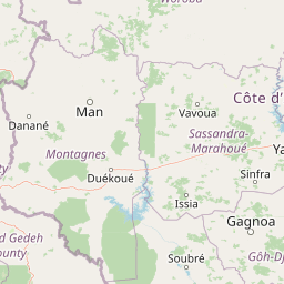
Map view of Marahoué National Park

Use this park location map to pinpoint Marahoué National Park in Ivory Coast, understand its exact geographic position, and read its mapped placement within the surrounding landscape more clearly.

Pigeon | © OpenStreetMap contributors

Location context for Marahoué National Park

Sassandra-Marahoué District
Park atlas

Compare surrounding regional geography and connected protected landscapes

Explore Protected Areas and National Parks Near Marahoué National Park

Continue geographic comparison by discovering other national parks and protected areas situated across the surrounding region. Analyzing adjacent conservation terrain helps place transitional savanna ecosystems and river basins into broader regional context.
National parkSassandra-Marahoué
About 0.3 km away#1 closest

South

Parc national de la Marahoué: Sassandra-Marahoué Protected Landscape and River Atlas

Analyzing the savanna and forest mosaic of Côte d'Ivoire

Parc national de la Marahoué represents a critical ecological junction in Côte d'Ivoire, spanning over 100,000 hectares along the Marahoué River. This protected area offers an analytical look at the intersection of Sudano-Guinean savanna and humid forest biomes, providing a unique case study in West African conservation landscapes and biodiversity patterns within the Sassandra-Marahoué region.

Area
1,010 km²
Established
1968
IUCN
II
Scope
Terrestrial
National parkIvory Coast
About 134 km away#2 closest

West

Mont Péko National Park: Ivory Coast National Park with Mapped Boundaries

Explore its protected landscape and regional geography.

Delve into Mont Péko National Park, a designated national park within Ivory Coast, to understand its unique protected landscape. This entry facilitates detailed atlas exploration, focusing on its geographic placement, mapped boundaries, and contribution to the regional natural terrain. Discover the essence of this protected area through its mapped geography and landscape identity.

Area
340 km²
Established
1968
IUCN
II
Relief
Mountain
National parkMontagnes
About 136 km away#3 closest

West

Parc national du Mont Péko: Mountain Rainforest and Granite Inselberg Geography

Protected mountain massif and watershed within the Montagnes District

Discover the unique mountain landscape of Parc national du Mont Péko. This protected area features dense primary forests, iconic granite inselbergs, and steep terrain that rises above the surrounding Ivorian plains. Use this mapped overview to understand its role in regional conservation and the watershed dynamics of the Sassandra River.

Area
340 km²
Established
1968
IUCN
II
Nature reserveIvory Coast
About 149 km away#4 closest

Southeast

Station d'écologie de Lamto: Nature Reserve and Protected Landscape in Ivory Coast

Examining the forest and savanna transition zone along the Bandama River

Station d'écologie de Lamto is a significant nature reserve situated at a unique ecological contact point in central Ivory Coast. This 2,500 hectare protected area encompasses Borassus palm savanna and gallery forest, serving as a landmark site for West African ecological research and the study of forest and savanna mosaic landscapes.

Area
25 km²
Established
1962
IUCN
Ia
Relief
Lowland
Protected areaIvory Coast
About 156 km away#5 closest

Southeast

Forêt classée de Divo: Protected Area and Forest Geography of Southwestern Ivory Coast

A study of humid Guinean forest remnants and regional land use

Discover the mapped landscape and protected status of the Forêt classée de Divo. Situated in the Divo department, this reserve highlights the interaction between Guinean-type humid forests and agricultural expansion, providing a critical look at state-managed forest conservation in southwestern Ivory Coast.

Area
20 km²
Established
1928
Relief
Lowland
Climate
Tropical
National parkDistrict des Montagnes
About 157 km away#6 closest

Southwest

Parc national de Taï: Primary Rainforest and Protected Terrain in District des Montagnes

Mapping intact forest corridors and major drainage systems

Parc national de Taï encompasses a vast, primary evergreen rainforest landscape that anchors the Upper Guinea forest block. This protected area features a complex topography of hills, plateaus, and permanent rivers, providing a vital habitat and a major site for scientific research in Côte d'Ivoire.

Area
4,540 km²
Established
1973
IUCN
II
Relief
Lowland
National parkIvory Coast
About 157 km away#7 closest

Southwest

Taï National Park: A Primary Rainforest Protected Area in Ivory Coast

Explore mapped boundaries and critical primate habitats in West Africa.

Taï National Park in Ivory Coast stands as a monumental protected landscape, comprising the largest contiguous area of primary rainforest remaining in West Africa. Its designation as a national park highlights its critical role in preserving biodiversity and unique geographic features. Users exploring this destination can delve into its mapped terrain, understand its regional landscape context within Ivory Coast, and appreciate its significance as a vital habitat for endangered species and an integral part of the Upper Guinean forest ecosystem.

Area
3,300 km²
Established
1972
IUCN
II
Relief
Upland
Nature reserveLôh-Djiboua
About 161 km away#8 closest

Southeast

Réserve botanique de Divo: Protected Forest Landscapes and Regional Geography in Lôh-Djiboua

Nature reserve featuring extensive forest restoration projects.

Discover the complex landscape of Réserve botanique de Divo, one of the oldest nature reserves in Côte d'Ivoire. Located in the Lôh-Djiboua region, this protected area represents a transition between remaining secondary forest fragments and agricultural land, serving as a primary site for international tropical forestry restoration efforts.

Area
68.02 km²
Established
1935
Relief
Lowland
Climate
Tropical

Common questions about visiting, size, designation, and location context for Marahoué National Park

Marahoué National Park FAQs for park facts, access, geography, and protected area context

Find quick answers about Marahoué National Park, including protected-area facts, park geography, trail and visitor context, and how the park fits into its surrounding country and regional landscape.
MoriAtlas Explorer

Continue Your Protected Areas Search Across the Global Atlas

Deepen your exploration by continuing the structured search for national parks and protected areas worldwide. Utilize the comprehensive filtering capabilities to compare different conservation landscapes and refine your understanding of global park geography. Discover more about the distribution and characteristics of protected natural areas.

Global natural geography