Mori Atlas logo
National parkMont Sângbé National Park

Discover the mapped boundaries and regional natural landscape context of Mont Sângbé National Park.

Mont Sângbé National Park National Park: Ivory Coast Protected Landscape Atlas and Geography

Mont Sângbé National Park stands as a designated national park within the geographic expanse of Ivory Coast. This page serves as your gateway to understanding its protected landscape identity, contributing to a structured atlas of conservation areas. Explore the mapped boundaries, regional context, and the natural terrain that defines this significant protected area in West Africa.

Mountain protected areaIUCN Category IIWest African savannaGallery forestImportant Bird AreaPrimate habitat

Mont Sângbé National Park

National park

Park overview

Structured park overview, official facts, and landscape profile for Mont Sângbé National Park

Mont Sângbé National Park park facts, protected area profile, and essential visitor context

Review the core facts for Mont Sângbé National Park, including designation, size, terrain, visitor scale, habitats, and operating context in one park-focused overview.

About Mont Sângbé National Park

Mont Sângbé National Park represents one of Ivory Coast's most ecologically significant protected areas, encompassing a remarkable diversity of habitats within its 950 square kilometer boundaries. The park is located within the Monts du Toura, a mountain range that forms the western edge of the Sassandra River basin and constitutes the eastern terminus of a highland chain extending from Guinea into northern Liberia. This positioning gives the park considerable biogeographic importance as a transitional zone between different ecological regions. The terrain is characterized by dramatic granite inselbergs and rocky peaks that rise abruptly from the surrounding landscape, creating a rugged and visually striking environment. Annual rainfall of approximately 1,350 millimeters supports dense vegetation cover despite the mountainous character of the terrain. The park's establishment in 1976 reflected Ivory Coast's commitment to preserving its natural heritage, and it has since become recognized as one of the nation's premier protected areas.

Quick facts and research context for Mont Sângbé National Park

Mont Sângbé National Park covers 95,000 hectares in the Monts du Toura region of western Ivory Coast, established in 1976 as a Category II protected area. The park features mountainous terrain with granite peaks exceeding 700 meters elevation, receiving approximately 1,350 mm of rainfall annually. It lies within the eastern extension of the highland chain running through Guinea and northern Liberia, creating a biogeographically significant zone between West African forest and savanna ecosystems.

Protection and recognition

Verifying terrestrial management boundaries and official conservation data in regional registers

Mont Sângbé National Park Documented Protection Status and Geographic Designation

Verifying the protected area designation of Mont Sângbé National Park helps researchers understand the terrestrial management scope and geographic boundaries of the reserve. Comparing global registry entries allows for clearer tracking of international conservation records, environmental protections, and regional management frameworks.

Protection details

Protection scope
Terrestrial
Park context

Deeper park guide and search-rich context for Mont Sângbé National Park

Mont Sângbé National Park history, landscape, wildlife, and travel context

Explore Mont Sângbé National Park through its history, landscape character, ecosystems, wildlife, conservation priorities, cultural context, and seasonal travel timing in a structured park guide built for atlas discovery and search intent.

Why Mont Sângbé National Park stands out

Mont Sângbé National Park is distinguished by its remarkable altitudinal range and the presence of both forest and savanna habitats within a single protected area. The park supports significant populations of western chimpanzees, with surveys documenting densities of 5.7 individuals per square kilometer in sampled areas. It has been designated an Important Bird Area by BirdLife International, recognizing its role in protecting significant bird populations including species such as Baumann's olive greenbul and emerald starling. The combination of granitic inselberg formations, gallery forests, and diverse savanna woodlands creates a visually striking landscape unique among West African protected areas.
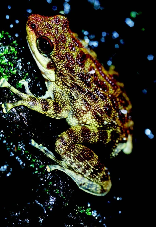
Brown and yellow spotted frog with red markings on its head resting on moss with dark background
Close-up of Odontobatrachus arndti frog on mossy surface

Mont Sângbé National Park history and protected-area timeline

Mont Sângbé National Park was established in 1976, acquiring formal national park status as part of Ivory Coast's expanding protected area network during the latter decades of the twentieth century. The park's designation reflected growing recognition of the ecological significance of the Monts du Toura region, which represents one of the more mountainous areas of Ivory Coast. During the early 2000s, scientific surveys conducted by Herbinger and Lia in 2001 provided important baseline data on western chimpanzee populations within the park, documenting densities that indicate healthy primate communities exist within the protected area. The park has maintained its IUCN Category II designation throughout its history, reflecting its primary objective of preserving natural ecosystems while allowing for controlled sustainable use in appropriate zones.

Mont Sângbé National Park landscape and geographic character

The landscape of Mont Sângbé National Park is dominated by the Monts du Toura, a range of mountains characterized by numerous granitic inselbergs and dramatic peaks that exceed 700 meters above sea level. These ancient rock formations create a distinctive silhouette against the West African sky and provide crucial habitat for specialized species adapted to rocky environments. The terrain is rugged and broken, with valleys and ridgelines creating diverse microhabitats throughout the park. The area lies at the eastern end of a highland chain that extends westward through Guinea and into northern Liberia, positioning the park within a mountainous corridor that has historically provided refugia for species during periods of climatic change. Annual rainfall of approximately 1,350 millimeters supports substantial vegetation cover, though the mountainous terrain creates variations in moisture and exposure that influence local vegetation patterns.

Mont Sângbé National Park ecosystems, habitats, and plant life

The vegetation of Mont Sângbé National Park exhibits considerable diversity, reflecting the park's transition between different ecological zones. The dominant habitat is dense savanna woodland, interspersed with patches of deciduous forest that occur either as isolated forest islands or as gallery forest along watercourses. In the southern portions of the park, two distinct savanna types occur based on soil drainage conditions. Well-drained soils support grasslands dominated by Brachiaria serrata and Andropogon macrophyllus grasses, with the trees Daniellia oliveri and Lophira lanceloata as principal woody species. Seasonally waterlogged soils in this area support fewer woody species and are characterized by Loudetia phragmitoides grass. The northern regions of the park experience drier conditions and support Sudanian woodland where Isoberlinia doka becomes a dominant tree species. This mosaic of habitats creates considerable ecological complexity within a relatively limited area.

Mont Sângbé National Park wildlife and species highlights

Mont Sângbé National Park supports remarkable mammalian diversity, with numerous species of conservation concern documented within its boundaries. The western chimpanzee represents perhaps the most significant primate species, with surveys indicating population densities of approximately 5.7 individuals per square kilometer in sampled areas. Other primates include the king colobus, sooty mangabey, and Diana monkey. The park supports diverse ungulate populations including African buffalo, bongo, several duiker species including Maxwell's, red-flanked, black, yellow-backed, and bay duikers, as well as royal antelope, oribi, bohor reedbuck, kob, waterbuck, western hartebeest, and roan antelope. Larger mammals include the African bush elephant and water chevrotain. Two crocodile species of conservation concern occur within the park: the slender-snouted crocodile and dwarf crocodile. The bird fauna, while incompletely surveyed, includes species such as Baumann's olive greenbul and emerald starling, and the park's designation as an Important Bird Area by BirdLife International reflects its significance for avian conservation.

Mont Sângbé National Park conservation status and protection priorities

Mont Sângbé National Park plays a crucial conservation role in West Africa as a protected area encompassing both highland forest and savanna ecosystems. The park's designation as an Important Bird Area by BirdLife International acknowledges its significance for bird conservation, with the area supporting significant populations of numerous species. The western chimpanzee population documented within the park represents an important conservation value, as this subspecies faces considerable pressure throughout its range across West Africa. The presence of multiple duiker species, African bush elephants, and other large mammals indicates a relatively intact mammalian community. The park's location within the Monts du Toura, at the eastern end of a highland chain extending through Guinea and Liberia, gives it particular importance as a protected area within a biogeographically significant mountainous corridor.

Mont Sângbé National Park cultural meaning and human context

The Mont Sângbé area lies within the traditional territory of several ethnic groups in western Ivory Coast, in a region characterized by mountainous terrain and relative geographic isolation. The park is situated between the towns of Man, Biankouma, and Touba in a region where traditional agricultural practices and community land management systems have historically shaped the landscape. While the park itself is now a protected area, surrounding communities maintain connections to the land and resources of the broader region.

Top sights and standout views in Mont Sângbé National Park

Mont Sângbé National Park stands out for its dramatic mountain scenery featuring granitic inselbergs and peaks rising above 700 meters, creating one of the most visually distinctive landscapes among West African protected areas. The park's ecological diversity is remarkable, supporting both forest and savanna habitats within a single protected area and serving as an Important Bird Area. The documented western chimpanzee population, with densities reaching 5.7 individuals per square kilometer, represents a significant conservation asset. The park's position at the eastern end of a highland chain extending through Guinea and northern Liberia gives it particular biogeographic significance, while its inclusion among the principal national parks of the world by Encyclopædia Britannica reflects its international recognition.

Best time to visit Mont Sângbé National Park

The optimal period for visiting Mont Sângbé National Park corresponds to the dry season, which typically runs from November to March in this region of West Africa. During this period, reduced rainfall improves accessibility and visibility within the park, making it easier to explore the mountainous terrain and observe wildlife. The dry season also concentrates animals around remaining water sources, potentially improving wildlife viewing opportunities. However, visitors should be prepared for conditions that can still include significant rainfall, as the climate in this mountainous region can be unpredictable. The wet season from April to October brings higher rainfall and more challenging conditions for exploration but offers the advantage of lush green landscapes and full watercourses.

Monthly climate preview

Long term temperature and precipitation averages recorded at reference coordinates

Mont Sangbe National Park Climate Normals and Annual Weather Patterns

Representative coordinate records show monthly mean temperatures fluctuating alongside shifting daily precipitation rates across the landscape. Examining the full twelve month climate profile reveals complete seasonal temperature ranges and monthly rainfall variations.
Annual mean25 °C
23 °C28 °C
Jan25°
Feb27°
Mar28°
Apr27°
May26°
Jun25°
Jul24°
Aug23°
Sep24°
Oct24°
Nov25°
Dec24°
Warmest month
March

27.6 °C

Coolest month
August

23.3 °C

Wettest month
August

7.9 mm/day

Driest month
January

0.3 mm/day

Park location guide

Geography guide, regional context, and park location map for Mont Sângbé National Park

Mont Sângbé National Park park geography, regions, and map view in Ivory Coast

Understand where Mont Sângbé National Park sits in Ivory Coast through a broader geographic reading of the surrounding landscape, nearby location context, and its mapped position within the national park landscape.

How Mont Sângbé National Park fits into Ivory Coast

Ivory Coast, officially the Republic of Côte d'Ivoire, is a West African country with a coastline on the Gulf of Guinea. It gained independence from France in 1960 and is now a presidential republic. The country is a major producer of cocoa and coffee, with Abidjan serving as its largest city and economic hub, while Yamoussoukro is the official capital.

Wider geography shaping Mont Sângbé National Park in Ivory Coast

Ivory Coast is situated on the southern coast of West Africa along the Gulf of Guinea. It borders Guinea to the northwest, Liberia to the west, Mali to the northwest, Burkina Faso to the northeast, Ghana to the east, and the Atlantic Ocean to the south. The terrain includes coastal plains, interior highlands, and forested regions.

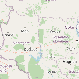
Map view of Mont Sângbé National Park

Use this park location map to pinpoint Mont Sângbé National Park in Ivory Coast, understand its exact geographic position, and read its mapped placement within the surrounding landscape more clearly.

Pigeon | © OpenStreetMap contributors

Discover the rugged terrain, granitic inselbergs, and unique forest-savanna mosaic across this West African protected area.

Explore Mont Sângbé National Park's Diverse Landscapes: Photos, Scenery, and Habitat Views

Visually explore Mont Sângbé National Park through this image gallery, highlighting its dramatic mountain scenery, unique granitic inselbergs, and diverse forest and savanna habitats. These protected area photos provide essential visual context, deepening your understanding of the park's terrain, ecosystems, and conservation significance within the wider West African highland chain.

Brown and yellow spotted frog with red markings on its head resting on moss with dark background

Park atlas

Uncover additional protected areas and their unique geographic context across the broader West African highland chain.

Browse More National Parks and Protected Areas Near Mont Sângbé National Park in West Africa

After exploring Mont Sângbé National Park, continue discovering other national parks and protected areas across the broader West African highland chain. Compare these diverse conservation landscapes to understand their distinct terrain features, regional biogeography, and protected-area distribution.
National parkMontagnes
Mapped park locations coincide#1 closest

Parc national du Mont Sangbé: A Rugged Highland Protected Area in the Montagnes District

Mountain forest landscape and highland topographic discovery.

Parc national du Mont Sangbé defines a major mountainous landscape within Côte d'Ivoire, characterized by an elevation profile that hosts fourteen summits above 1,000 meters. This protected area serves as an essential habitat for forest wildlife and supports a continuous tree canopy that shapes the ecology of the Montagnes region. Its unique highland topography makes it a primary subject for mapping the diverse physical geography and conservation zones of West Africa.

Area
950 km²
Established
1975
IUCN
II
Relief
Mountain
National parkIvory Coast
About 106 km away#2 closest

South

Mont Péko National Park: Ivory Coast National Park with Mapped Boundaries

Explore its protected landscape and regional geography.

Delve into Mont Péko National Park, a designated national park within Ivory Coast, to understand its unique protected landscape. This entry facilitates detailed atlas exploration, focusing on its geographic placement, mapped boundaries, and contribution to the regional natural terrain. Discover the essence of this protected area through its mapped geography and landscape identity.

Area
340 km²
Established
1968
IUCN
II
Relief
Mountain
National parkMontagnes
About 108 km away#3 closest

South

Parc national du Mont Péko: Mountain Rainforest and Granite Inselberg Geography

Protected mountain massif and watershed within the Montagnes District

Discover the unique mountain landscape of Parc national du Mont Péko. This protected area features dense primary forests, iconic granite inselbergs, and steep terrain that rises above the surrounding Ivorian plains. Use this mapped overview to understand its role in regional conservation and the watershed dynamics of the Sassandra River.

Area
340 km²
Established
1968
IUCN
II
Protected areaNimba County
About 148 km away#4 closest

West

Nimba National Forest: Protected Mountain Landscape & Bird Area in Nimba County

Explore mapped boundaries and regional geographic context.

Nimba National Forest, a protected area of approximately 187 square kilometers, is defined by its mountainous terrain in Nimba County, Liberia. Situated at the tri-border region with Guinea and Ivory Coast, this forest is recognized for its importance as a habitat for diverse bird species and its role in regional conservation efforts. Discover its mapped landscape, its position within the Nimba Range, and its ecological significance within West Africa's protected natural areas.

Area
187 km²
IUCN
VI
Access
Access unknown
Scope
Terrestrial
National parkSassandra-Marahoué District
About 167 km away#5 closest

Southeast

Marahoué National Park: Geographic and Protected Landscape Analysis in Central Ivory Coast

Examining the ecological terrain within the Sassandra-Marahoué District

Marahoué National Park occupies a transitional zone where forest remnants meet savanna grasslands in the heart of Ivory Coast. This analysis explores the park's geographic boundaries along the Marahoué River and the shifting habitats that continue to sustain a notable variety of bird species within this protected district.

Area
1,000 km²
Established
1968
IUCN
II
Relief
Upland
National parkSassandra-Marahoué
About 167 km away#6 closest

Southeast

Parc national de la Marahoué: Sassandra-Marahoué Protected Landscape and River Atlas

Analyzing the savanna and forest mosaic of Côte d'Ivoire

Parc national de la Marahoué represents a critical ecological junction in Côte d'Ivoire, spanning over 100,000 hectares along the Marahoué River. This protected area offers an analytical look at the intersection of Sudano-Guinean savanna and humid forest biomes, providing a unique case study in West African conservation landscapes and biodiversity patterns within the Sassandra-Marahoué region.

Area
1,010 km²
Established
1968
IUCN
II
Scope
Terrestrial
Nature reservePréfecture de Yomou
About 201 km away#7 closest

West

Réserve forestière de Diécké: Protected Forest Geography and Landscape Features

A critical lowland rainforest zone in Guinea

The Réserve forestière de Diécké protects 64,000 hectares of primary and secondary dense forest in southeastern Guinea. Its rugged, hilly terrain and river-carved lowlands support a closed-canopy ecosystem, providing a vital model for zoned forest conservation in the West African region.

Area
640 km²
Relief
Upland
Climate
Tropical
Scope
Terrestrial
National parkDistrict des Montagnes
About 206 km away#8 closest

South

Parc national de Taï: Primary Rainforest and Protected Terrain in District des Montagnes

Mapping intact forest corridors and major drainage systems

Parc national de Taï encompasses a vast, primary evergreen rainforest landscape that anchors the Upper Guinea forest block. This protected area features a complex topography of hills, plateaus, and permanent rivers, providing a vital habitat and a major site for scientific research in Côte d'Ivoire.

Area
4,540 km²
Established
1973
IUCN
II
Relief
Lowland

Common questions about visiting, size, designation, and location context for Mont Sângbé National Park

Mont Sângbé National Park FAQs for park facts, access, geography, and protected area context

Find quick answers about Mont Sângbé National Park, including protected-area facts, park geography, trail and visitor context, and how the park fits into its surrounding country and regional landscape.
MoriAtlas Explorer

Continue Your Protected Areas Search Across the Global Atlas

Deepen your exploration by continuing the structured search for national parks and protected areas worldwide. Utilize the comprehensive filtering capabilities to compare different conservation landscapes and refine your understanding of global park geography. Discover more about the distribution and characteristics of protected natural areas.

Global natural geography