
Streams
Park geography
A technical analysis of elevation ranges, protected forest area, and regional terrain.
Mark O. Hatfield Wilderness in Oregon: Detailed Geographic Profile and Land Boundaries
Mark O. Hatfield Wilderness spans a recorded area of 266.37 square kilometers, characterized by a mountainous relief reaching elevations from 30 to 1494 meters. This protected landscape contains diverse features including forested plateaus, alpine meadows, and various named streams and waterfalls like Gorton Creek and Wahe Falls.
Related tags
wilderness areaCascade RangeMount HoodColumbia River Gorgeold-growth forest
A Cascade wilderness of basalt cliffs, old-growth forests, and waterfall-lined trails on the north face of Mount Hood.
Mark O. Hatfield Wilderness
The Mark O. Hatfield Wilderness is a federally designated wilderness area set on the northern slopes of Mount Hood in the northwestern Cascade Range of Oregon. Sitting within the broader Mount Hood National Forest and adjacent to the Columbia River Gorge, the wilderness protects a steep and varied landscape that climbs from the Columbia River nearly five thousand feet into subalpine terrain. Its combination of deep canyons, towering basalt features, old-growth forests, and long-distance trails has made it one of the more popular Cascade wilderness destinations near Portland. The area is named in honor of Mark Hatfield, a longtime Oregon governor and United States senator who was a notable advocate for conservation and public lands. The wilderness is defined by its dramatic vertical relief, with elevation shifting from low along the Columbia River to high along the ridges and peaks overlooking the Gorge. Major drainages such as Herman Creek, Eagle Creek, and Tanner Creek have carved the terrain into some of the most iconic canyon scenery in the Pacific Northwest. Within this setting, the wilderness preserves old-growth Douglas-fir, hemlock, and cedar stands at lower elevations, while higher zones transition to forested plateaus, hanging meadows, subalpine lakes, and exposed ridgelines with sweeping views. Recreation is one of the defining aspects of the Hatfield Wilderness, drawing hikers, backpackers, and nature observers throughout the warmer months. Around two hundred miles of trails wind through the area, including a segment of the Pacific Crest Trail, and the proximity of the wilderness to the Portland metropolitan area makes it an accessible escape into the Cascades. The area's mix of geological grandeur, mature forests, and waterfall-rich canyons gives it a strong sense of place within Oregon's protected landscapes.
- Location
- United States of America
- Park type
- Wildlife reserve
- Established
- 1984
- Area
- 266.4 km²
- Highest point
- 1,494 m
Location overview
Administered across the United States of America and Oregon
Geographic Setting and Regional Location of Mark O. Hatfield Wilderness
Mark O. Hatfield Wilderness occupies designated lands within the United States of America and Oregon. Administrative records track territorial memberships and high-level geographic status across this protected territory.
- Countries
- United States of America
- Regions
- Oregon
- Primary location
- Oregon
- Geographic setting
- Inland
Boundary and coordinates
Interactive boundary geometry and measured geographic area overview
Mark O. Hatfield Wilderness Boundary Map and Spatial Extent
Mapped boundary outlines provide spatial context for exploring the protected territory. Recorded measurements supply structured area metrics and coordinate spans without legal survey claims.
- Boundary area
- 264.9 km²
- Boundary perimeter
- 165.2 km
- Northernmost point
- 45.6951° N
- Southernmost point
- 45.5186° N
- Easternmost point
- 121.6474° W
- Westernmost point
- 122.1124° W
- Geographic centre
- 45.609° N, 121.8693° W
- North–south span
- 19.6 km
- East–west span
- 36.3 km
Elevation and terrain
Mountain relief mapping and recorded natural features
Mark O. Hatfield Wilderness Terrain and Elevation Range Geography
Mark O. Hatfield Wilderness features a recorded elevation range spanning from thirty meters to one thousand four hundred ninety-four meters. Linked feature cards supply names, types, and spatial relationships for streams, lakes, waterfalls, and ridges located within the protected area.
- Minimum elevation
- 30 m
- Maximum elevation
- 1,494 m
- Highest point
- 1,494 m
Selected named natural features
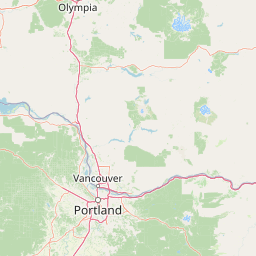
Streams
Gorton Creek
Lakes
Bear Lake
Lakes
Tanner Lake
Waterfalls
Gorton Creek Falls
Streams
Cabin Creek
Environmental setting
Temperate mountain relief, forest cover, and diverse habitat classifications
Environmental Setting and Landscape Classifications of Mark O. Hatfield Wilderness
Stored landscape features, habitat types, and relief classifications frame the physical setting of Mark O. Hatfield Wilderness across temperate zones. Recorded categories connect directly to related protected areas and regional atlas destinations.
- Relief
- Mountain
- Climate
- Temperate
- Forest cover
- Mostly forested
- Seasonality
- Seasonal
Landscape features
Mountains · Plateau · Cliffs · Forest · Lakes · Rivers · Waterfalls
Habitat types
Temperate coniferous forest · Montane forest · Alpine meadow
Park atlas
Compare adjacent Cascade Range landscapes and connected regional reserves
Parks Near Mark O. Hatfield Wilderness and Surrounding Protected Areas
Visitors exploring Mark O. Hatfield Wilderness can compare adjacent protected areas across the surrounding region. Broadening the geographic scope reveals connected mountain terrain and similar regional park habitats.

Protected landscapeOregon
Park boundaries overlap#1 closest
Southeast

Mount Hood National Forest: Atlas of Protected Landscapes and Volcanic Geography
Exploring the Cascade Range terrain and wilderness boundaries in Oregon.
Mount Hood National Forest encompasses a vast, rugged expanse of the Oregon Cascades, anchored by the iconic, glacier-clad Mount Hood. This protected landscape contains extensive old-growth forests, high-alpine lakes, and deep river canyons. Discover the geographic extent of these wilderness areas and mountain terrain within the MoriAtlas database of protected lands.
- Area
- 4,318.17 km²
- Established
- 1908
- Visitors
- 4.4M annual
- Relief
- Mountain

Protected landscapeWashington
0.7 km away#2 closest
North
Gifford Pinchot National Forest: Geographic Overview of Washington's Volcanic Cascade Protected Lands
Mapping volcanic peaks, deep river canyons, and old-growth wilderness corridors
Gifford Pinchot National Forest represents a major protected expanse in the Washington Cascades, characterized by a complex volcanic topography that includes active craters, cinder cones, and rugged lava fields. This atlas entry details the forest's primary geographic features, from the high-elevation alpine terrain of the Goat Rocks to the river-carved valleys of the Lewis and Cowlitz systems, providing essential context on this integral Pacific Northwest protected landscape.
- Area
- 5,347.95 km²
- Established
- 1908
- Visitors
- 1.8M annual
- Relief
- Mountain
Wildlife reserveOregon
12 km away#3 closest
South
Mount Hood Wilderness: Atlas of Volcanic Peaks and Glacial Geography in Oregon
High-altitude protected landscapes and forest ecosystems
This protected area captures the dramatic character of the Cascade Range through its signature volcanic terrain, ancient forests, and high-alpine ridges. Covering a vast vertical range, the wilderness offers a study in geologic forces, featuring active glaciers, deep basaltic canyons, and meadows that define the mountain's northern and western slopes.
- Area
- 262 km²
- Established
- 1964
- IUCN
- Ib
- Visitors
- 10K annual
Protected landscapeOregon
18 km away#4 closest
South
Mount Hood National Recreation Area: Oregon Protected Landscape and Regional Geography
A three-unit recreational forest landscape in the Cascade Range.
Spanning over 34,000 acres, this protected landscape frames the lower volcanic slopes and forested drainages around Mount Hood. The area integrates river corridors, wilderness boundaries, and subalpine terrain, offering a clear view of the complex topography that defines the Cascade Range in northern Oregon.
- Area
- 139.8 km²
- Established
- 2009
- Relief
- Mountain
- Climate
- Temperate
Wildlife reserveWashington
27 km away#5 closest
North
Indian Heaven Wilderness: Volcanic Plateau Geography and Protected Cascade Landscapes
Volcanic peaks, high-elevation lakes, and expansive meadows in Washington.
Indian Heaven Wilderness encompasses a broad volcanic plateau in the southern Washington Cascades, famous for its dense concentration of lakes, ponds, and volcanic landforms. The area features a complex mosaic of cinder cones, shield volcanoes, and subalpine forests, offering a unique geographic perspective on the Pacific Northwest. Delve into the protected boundaries and mapped terrain of this significant wilderness area.
- Area
- 84.1 km²
- Established
- 1984
- Visitors
- 8K annual
- Relief
- Mountain
Wildlife reserveOregon
About 35 km away#6 closest
South
Roaring River Wilderness: Geography and Protected Area Atlas of Oregon
Ancient forest corridors and alpine lake landscapes
Roaring River Wilderness is a federally protected landscape in Oregon, defined by steep, tree-covered ridges and the vigorous Roaring River. This wilderness preserves a dense mosaic of old-growth conifers, high-elevation alpine lakes like Serene and Shellrock, and important salmon-spawning waters within the broader Mount Hood National Forest geography.
- Area
- 148 km²
- Established
- 2009
- IUCN
- Ib
- Relief
- Mountain
Wildlife reserveWashington
47 km away#7 closest
Northeast
Mount Adams Wilderness: Volcanic Terrain and Protected Landscapes in Washington State
Mapping the high altitude meadows and volcanic ridges
Spanning roughly 47,700 acres, Mount Adams Wilderness presents a unique geological mosaic of cinder cones, lava flows, and permanent snowfields. The area offers a profound look at Cascade Range geography, from its western forested valleys to its open alpine basins, serving as a critical protected landscape for understanding volcanic, glacial, and fluvial processes in the Pacific Northwest.
- Area
- 193.07 km²
- Established
- 1964
- IUCN
- Ib
- Relief
- Mountain
Protected landscapeOregon
72 km away#8 closest
South
Willamette National Forest: Geography and Protected Landscapes of the Central Oregon Cascades
Mapped terrain, old-growth forests, and protected wilderness boundaries.
Explore the expansive territory of Willamette National Forest, a primary protected area extending over 100 miles along Oregon's Cascade Range. This region features volcanic peaks exceeding 10,000 feet, extensive old-growth Douglas-fir stands, and a dense network of Wild and Scenic rivers, providing a detailed look at the geographic character and ecological heritage of the Pacific Northwest.
- Area
- 6,790.75 km²
- Established
- 1933
- Visitors
- 1.7M annual
- Relief
- Mountain
MoriAtlas Explorer
Continue Exploring the Mark O. Hatfield Wilderness Landscape
Navigate the complex topography and protected boundaries of this Cascade Range landmark. MoriAtlas provides a clear view of the geological features and forest ecosystems that define this protected Oregon wilderness area for ongoing geographic discovery.
Browse next
Global natural geography
Explore related park routes
Explore MoriAtlas Global ParksBrowse All MoriAtlas ParksGlobal Park Map DiscoveryMoriAtlas: Browse All CountriesBrowse All MoriAtlas ContinentsNational Park Environment AtlasGrand Canyon National Park AtlasYellowstone National Park AtlasYosemite National Park Atlas and GeographySerengeti National Park AtlasGalápagos National Park Protected LandscapeBanff National Park Geography and AtlasKruger National Park Atlas EntryUluṟu-Kata Tjuṯa National Park AtlasExplore Uluru-Kata Tjuta National Park GeographyPlitvice Lakes National Park AtlasFiordland National Park Protected LandscapeGreat Smoky Mountains National Park AtlasAfghanistan National Parks and Protected AreasAlbania National Parks and Protected AreasAlgeria National Parks and Protected AreasAmerican Samoa National Parks and Protected AreasAndorra National Parks and Protected AreasAngola National Parks and Protected AreasAntarctica National Parks and Protected AreasAntigua and Barbuda Park List