Mori Atlas logo
Wildlife reserveMark O. Hatfield Wilderness

Explore the dramatic basalt canyons, old-growth forests, and rugged Cascade Range terrain of this significant wilderness area.

Mark O. Hatfield Wilderness: A Comprehensive Atlas of Oregon Protected Mountain Landscapes

The Mark O. Hatfield Wilderness encompasses a remarkable range of terrain on the northern slopes of Mount Hood, stretching from the Columbia River Gorge up to subalpine peaks. This protected landscape is defined by deep basalt canyons, towering cliffs, and a dense network of forest trails that transition from lush low-elevation woodlands into open mountain meadows. Through this geographic profile, you can examine the vertical relief, geological features, and expansive trail connections that characterize this essential segment of the Oregon Cascades.

wilderness areaCascade RangeMount HoodColumbia River Gorgeold-growth forestDouglas-fir forest

Mark O. Hatfield Wilderness

Wildlife reserve

Park overview

Structured park overview, official facts, and landscape profile for Mark O. Hatfield Wilderness

Mark O. Hatfield Wilderness park facts, protected area profile, and essential visitor context

Review the core facts for Mark O. Hatfield Wilderness, including designation, size, terrain, visitor scale, habitats, and operating context in one park-focused overview.

About Mark O. Hatfield Wilderness

The Mark O. Hatfield Wilderness occupies one of the most scenically striking positions in Oregon's Cascade Range, anchored along the northern flanks of Mount Hood and the southern rim of the Columbia River Gorge. It sits within the Mount Hood National Forest and spans Hood River and Multnomah counties, bringing together alpine-influenced Cascade terrain with the deep canyon country of the Gorge. Few wilderness areas in the Pacific Northwest compress so much topographic variety into a single protected landscape, and this concentration of features is central to the area's identity.

Geologically, the wilderness is shaped by the powerful interaction between Cascade volcanism and the ancient basalt flows of the Columbia River Gorge. The northern portion of the area displays classic Gorge characteristics: towering basalt cliffs, dramatic columnar formations, and dozens of waterfalls cascading over successive lava layers. As elevation rises moving south toward Mount Hood, the terrain transitions into forested ridges, talus slopes, glacial features, and small subalpine lakes. Elevations range from around 100 feet near the Columbia River to about 4,900 feet at the summit of Mount Defiance, producing an unusually steep and varied gradient within a relatively compact footprint.

Ecologically, this range of elevation and exposure supports a rich diversity of forest types. Lower slopes harbor old-growth stands of Douglas-fir, western hemlock, and western red cedar, while mid-elevations grade into mixed coniferous forest. Higher elevations include open plateaus and hanging meadows interspersed with subalpine lakes and exposed rocky ridges. The combination of mature forest, cliff environments, riparian corridors along creeks like Eagle Creek, Herman Creek, and Tanner Creek, and rugged upland terrain creates habitat complexity that supports a wide variety of plant and animal life.

Recreation and accessibility are central to the wilderness experience. Approximately 200 miles of trails traverse the area, including about 14 miles of the Pacific Crest Trail, allowing hikers to move between deep canyon waterfalls, forested valley walks, and high country with panoramic Cascade views. Its proximity to Portland and Hood River makes the wilderness a popular escape for day hikers and backpackers while still feeling remote enough to deliver a true backcountry experience. The wilderness also stands as a tribute to Mark Hatfield, Oregon's longest-serving senator and a former governor, whose legacy in conservation helped shape protections across the state's public lands.

Quick facts and research context for Mark O. Hatfield Wilderness

Mark O. Hatfield Wilderness is a U.S. Forest Service wilderness area spanning Hood River and Multnomah counties in northwestern Oregon. It lies on the north side of Mount Hood within the Mount Hood National Forest, bordering the Columbia River Gorge and rising from near sea level along the river to roughly 4,900 feet at Mount Defiance. The wilderness contains roughly 65,800 acres of protected terrain, was designated in 1984, and is classified as IUCN Category Ib. Prior to its wilderness designation, the area was managed as the Columbia Gorge Recreation Area.

Protection and recognition

Documented terrestrial protection framework established in 1984

Mark O. Hatfield Wilderness Protection Status and Designation History

Mark O. Hatfield Wilderness maintains a documented terrestrial protection status established in the designation year of 1984. Official records outline the baseline conservation scope and administrative history without additional international recognition sources.

Protection details

Protection scope
Terrestrial
Designated year
1984
Transboundary protection
No
Park context

Deeper park guide and search-rich context for Mark O. Hatfield Wilderness

Mark O. Hatfield Wilderness history, landscape, wildlife, and travel context

Explore Mark O. Hatfield Wilderness through its history, landscape character, ecosystems, wildlife, conservation priorities, cultural context, and seasonal travel timing in a structured park guide built for atlas discovery and search intent.

Why Mark O. Hatfield Wilderness stands out

The Mark O. Hatfield Wilderness is best known for the towering basalt cliffs and dense concentration of waterfalls along its northern edge, where the Cascade Range meets the Columbia River Gorge. This dramatic geological transition creates deep, narrow canyons cut by creeks such as Eagle Creek and Herman Creek, with falls plunging over old lava flows. Combined with old-growth forests of Douglas-fir, hemlock, and cedar and a network of roughly two hundred miles of trails, including a stretch of the Pacific Crest Trail, the wilderness has become a signature Cascade landscape for waterfall scenery and rugged gorge hiking.
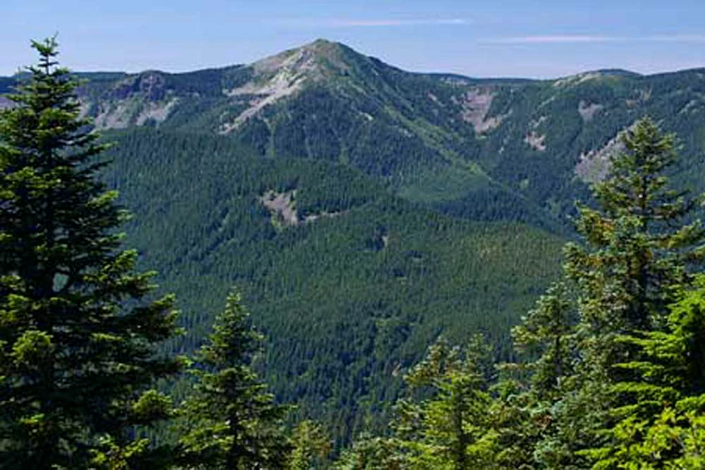
A mountainous wilderness landscape featuring dense conifer forests in the foreground and midground, with a prominent peak in the distance under a clear blue sky.
A wide view of the forested slopes within the Mark O. Hatfield Wilderness.

Mark O. Hatfield Wilderness history and protected-area timeline

The Mark O. Hatfield Wilderness was formally designated in 1984, extending federal wilderness protection to a substantial portion of the land on the north side of Mount Hood. Prior to its designation, the area was managed as the Columbia Gorge Recreation Area, a use-based framework that allowed recreation but did not provide the higher level of preservation associated with wilderness status. The shift to wilderness designation placed the area under the National Wilderness Preservation System and emphasized ecological protection alongside recreational use.

The wilderness is named for Mark Hatfield, who served as governor of Oregon from 1959 to 1967 and as a United States senator from 1967 to 1997. During his long public career, Hatfield was widely respected for his work on conservation, public lands, and bipartisan environmental stewardship. Naming the wilderness after him connected the area to a political legacy of protecting Oregon's natural landscapes, and the designation itself became part of a broader wave of wilderness protections in the Cascade Range during the 1980s.

Since its establishment, the wilderness has been administered by the U.S. Forest Service as part of the Mount Hood National Forest. Its management has focused on preserving the area's wilderness character, including its old-growth forests, basalt-cliff scenery, and extensive trail network, while accommodating the heavy recreational demand generated by its proximity to Portland and the Columbia River Gorge.

Mark O. Hatfield Wilderness landscape and geographic character

The landscape of the Mark O. Hatfield Wilderness is defined by a striking vertical transition from the lower Columbia River to the upper slopes of Mount Hood. Near the river, elevations drop to around 100 feet, while the higher ridges and summits rise to nearly 4,900 feet, producing a gradient that packs an enormous amount of topographic diversity into a relatively compact area. The result is a wilderness where deep canyons, towering cliffs, forested valleys, and subalpine ridges all sit within sight of one another.

The northern portion of the wilderness carries the unmistakable character of the Columbia River Gorge. Towering basalt cliffs rise abruptly from the canyon floor, their layered volcanic faces shaped by successive lava flows and millennia of erosion. Water plays a defining role in this terrain: creeks cascade over the cliff edges in long, multi-tiered falls, creating some of the most iconic waterfall scenery in the Pacific Northwest. Eagle Creek, Herman Creek, and Tanner Creek have carved deep, narrow valleys into this basalt plateau, leaving behind a maze of side canyons, sheer walls, and talus aprons.

Moving south and upward, the landscape gradually shifts from Gorge-style basalt terrain to the more typical features of the Cascade Range. The slopes rise more steeply toward an uneven plateau, then continue upward into mountain peaks, talus slopes, and small lakes. Forests thicken across the mid-elevations, broken occasionally by open meadows and exposed rocky ridges. From the higher viewpoints, visitors are rewarded with broad panoramas that take in both the Columbia River Gorge below and the volcanic profile of Mount Hood above, capturing both the geological forces that have shaped the region.

Mark O. Hatfield Wilderness ecosystems, habitats, and plant life

Ecologically, the Mark O. Hatfield Wilderness reflects the meeting point between two distinct natural systems in the Pacific Northwest: the Columbia River Gorge and the Cascade Range. This transitional position gives the area a layered biological character, with lower elevations influenced by the Gorge's relatively dry, continental-influenced climate and higher elevations taking on the wetter, cooler conditions typical of the Cascades.

At lower elevations, the wilderness supports impressive stands of old-growth forest, including towering Douglas-fir, western hemlock, and western red cedar. These mature trees form dense canopies along the canyon walls and valley bottoms, providing some of the richest old-growth habitat associated with the Gorge. The cool, shaded microclimates near the creeks also support mosses, ferns, and moisture-loving understory plants, contributing to the lush, rainforest-like appearance often associated with the area's waterfall trails.

As elevation increases, the vegetation transitions into mixed coniferous forest with a different species composition and structure. Mid- and upper-elevation slopes feature forested plateaus and ridges broken by hanging meadows, talus openings, and small subalpine lakes. These higher habitats support hardier plant communities adapted to harsher weather and shorter growing seasons, and they provide quiet, scenic transitions between forest and alpine terrain. The combined effect is an ecological gradient within a single wilderness, ranging from steep, basalt-cliff riparian corridors to subalpine ridges and meadows.

Mark O. Hatfield Wilderness wildlife and species highlights

The diversity of habitats across the Mark O. Hatfield Wilderness supports a wide range of wildlife typical of the Cascade Range and the Columbia River Gorge. The mix of mature old-growth forest, cliff environments, creek corridors, and subalpine ridges creates habitat variety that benefits both resident and migratory species, and the wilderness functions as an important refuge within an otherwise heavily developed regional landscape.

In the forested lower and mid-elevations, common species include black-tailed deer, elk, black bears, and a wide variety of small mammals such as squirrels and chipmunks. The dense canopy and downed woody debris in the old-growth zones also provide habitat for forest-dwelling birds and small predators. Raptors are frequently observed along the cliffs and rim edges of the Gorge, where updrafts and exposed rock faces offer ideal hunting conditions. The area's waterfalls and cliff environments are likewise associated with species that thrive on rugged terrain and undisturbed forest interior.

Herman Creek, Eagle Creek, and Tanner Creek corridors add strong riparian habitat value, supporting amphibians, aquatic invertebrates, fish, and the birdlife associated with cool, shaded streams. Higher elevations, including the meadows and ridgelines near Mount Defiance, are important for species that depend on open or edge habitats in summer. Because the area is close to Portland and other population centers, the wilderness also plays a notable role in maintaining functional wildlife habitat within a region where development pressure is intense.

Mark O. Hatfield Wilderness conservation status and protection priorities

The Mark O. Hatfield Wilderness carries substantial conservation significance because it protects a transition zone where two of the Pacific Northwest's most important ecological systems converge. Its northern edge preserves a portion of the Columbia River Gorge, one of the most ecologically distinct river canyons in North America, while its southern portion shields parts of the Mount Hood landscape within the broader Cascade Range. This combination gives the wilderness an outsized ecological value relative to its size.

A core conservation feature is the protection of old-growth forest habitat. Lower-elevation stands of Douglas-fir, western hemlock, and western red cedar have been allowed to develop with minimal human disturbance, preserving old-growth characteristics that are increasingly rare across the region. These forests provide essential habitat for species dependent on mature canopy structure, snags, and large woody debris, while also storing significant carbon and supporting watershed health.

Equally important is the role the wilderness plays in protecting the geological and hydrological features of the Columbia River Gorge. The towering basalt cliffs, layered lava formations, and dozens of waterfalls are preserved under wilderness management, safeguarding both their scenic value and the ecological systems tied to them. By elevating the area's status from a recreation area to a federally designated wilderness in 1984, Congress ensured long-term protection for these features under the National Wilderness Preservation System, administered by the U.S. Forest Service. The wilderness continues to serve as a critical natural buffer near the Portland metropolitan area, demonstrating the importance of nearby protected landscapes in sustaining regional biodiversity.

Mark O. Hatfield Wilderness cultural meaning and human context

The Mark O. Hatfield Wilderness carries a strong cultural connection through its association with Mark Hatfield, one of Oregon's most prominent political figures of the twentieth century. Hatfield served as governor of Oregon from 1959 to 1967 and then as a U.S. senator for three decades, from 1967 to 1997. Throughout his career, he was widely regarded for his commitment to conservation, ethics in public life, and stewardship of Oregon's natural resources. Naming the wilderness after him reflected both his political stature and his lasting influence on the state's environmental legacy.

Beyond its political associations, the wilderness holds a cultural significance tied to Oregon's outdoor identity. Its proximity to Portland and Hood River has made it a beloved outdoor space for generations of hikers, backpackers, and nature enthusiasts. The area's waterfalls, gorge trails, and Cascade vistas have become part of the regional imagination, often appearing in photographs, hiking guides, and travel literature that shape how both Oregonians and visitors relate to the state's landscapes. The earlier Columbia Gorge Recreation Area identity also reflects a longer history of public use and appreciation for this stretch of the Gorge.

Top sights and standout views in Mark O. Hatfield Wilderness

The Mark O. Hatfield Wilderness stands out for the sheer density of its basalt cliffs and waterfalls, particularly along its northern Gorge-facing canyons. Eagle Creek and its tributaries offer some of the most celebrated waterfall hikes in the Pacific Northwest, while Herman Creek and Tanner Creek provide quieter, equally dramatic alternatives. The wilderness also protects extensive old-growth forest, with Douglas-fir, western hemlock, and cedar stands at lower elevations giving way to mixed conifer forest higher up.

Another defining highlight is the area's trail network, totaling roughly 200 miles, which connects waterfall canyons to forested ridges, hanging meadows, and subalpine lakes. A segment of the Pacific Crest Trail passes through the wilderness, linking it to the broader Cascade backcountry. Combined with sweeping viewpoints over both the Gorge and Mount Hood, the wilderness offers a compact but remarkably varied experience of Oregon's mountain and gorge environments.

Best time to visit Mark O. Hatfield Wilderness

The most favorable period for visiting the Mark O. Hatfield Wilderness is generally from late spring through early fall, when the snow has melted from the trails and the waterfalls are flowing strongly. Spring and early summer often bring vigorous runoff from snowmelt, making the falls especially powerful and the creeks full, while also filling the higher meadows and subalpine lakes. Summer offers the most reliable trail conditions, with wildflowers in the higher meadows, stable weather for backpacking, and long daylight hours for reaching viewpoints along the ridges.

Late summer into early autumn can also be rewarding, with cooler temperatures, fewer crowds, and the first hints of fall color in the forests. Winter brings heavy snow at higher elevations and creates serious avalanche risk in the steep canyon terrain, making much of the wilderness inaccessible to casual visitors; the lower-elevation Gorge trails near the river may still be walked but require caution in freezing conditions. Visitors planning to experience both the waterfalls and the high country will typically find late spring or summer to be the most balanced window.

Monthly climate preview

Long-term monthly temperature and precipitation patterns recorded at representative elevations

Mark O. Hatfield Wilderness Climate Normals and Annual Temperature Rhythm

Representative coordinates for Mark O. Hatfield Wilderness record a measured annual cycle of shifting temperatures and monthly precipitation volumes spanning 1991 through 2020. Examining the complete twelve-month climatology profile reveals deeper multi-variable trends across the entire regional protected landscape.
Annual mean8 °C
1 °C17 °C
Jan
Feb
Mar
Apr
May11°
Jun13°
Jul17°
Aug17°
Sep14°
Oct
Nov
Dec
Warmest month
August

17.5 °C

Coolest month
December

0.6 °C

Wettest month
December

7.7 mm/day

Driest month
July

0.5 mm/day

Park location guide

Geography guide, regional context, and park location map for Mark O. Hatfield Wilderness

Mark O. Hatfield Wilderness park geography, regions, and map view in United States of America

Understand where Mark O. Hatfield Wilderness sits in United States of America through a broader geographic reading of the surrounding landscape, nearby location context, and its mapped position within the national park landscape.

How Mark O. Hatfield Wilderness fits into United States of America

The United States of America is a federal presidential republic and one of the world's largest countries by area and population. It consists of 50 states across a vast territory spanning multiple time zones, with its capital in Washington, D.C. and largest city in New York City. The nation has a diverse economy, influential political system, and significant cultural and military presence globally.

Wider geography shaping Mark O. Hatfield Wilderness in United States of America

The United States occupies a vast territory in North America, bordered by Canada to the north and Mexico to the south. The 48 contiguous states stretch from the Atlantic to the Pacific Ocean, while Alaska occupies the northwestern region and Hawaii is an archipelago in the Pacific. The country encompasses diverse terrain including the Rocky Mountains, Appalachian Mountains, Great Plains, and extensive river systems.

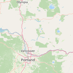
Map view of Mark O. Hatfield Wilderness

Use this park location map to pinpoint Mark O. Hatfield Wilderness in United States of America, understand its exact geographic position, and read its mapped placement within the surrounding landscape more clearly.

Pigeon | © OpenStreetMap contributors

Location context for Mark O. Hatfield Wilderness

Oregon
Natural feature types

Explore the Topographic Features and Landforms of Mark O. Hatfield Wilderness

Navigate the structured catalog of natural features associated with the Mark O. Hatfield Wilderness. This resource provides a detailed look at the basalt cliffs, river drainages, and ridgelines that define the wilderness landscape across the Cascade Range.
Recorded earthquake history

View the Mark O. Hatfield Wilderness Historical Earthquake Catalogue

Investigate the history of seismic activity recorded in the areas surrounding this Oregon wilderness. MoriAtlas provides a clear, data-driven collection of earthquake events associated with the park, helping users analyze regional geological patterns and historical seismic occurrences near the Mount Hood National Forest.

Mark O. Hatfield Wilderness Earthquake History

Catalogued events

29 events

Strongest magnitude

Magnitude 4.5

Most recent event

Jun 6, 2021

This history includes earthquakes recorded inside the park or within 50 km of its borders

Visual reference for rugged gorge terrain, old-growth forests, and steep Cascade elevation gradients.

Mark O. Hatfield Wilderness Photos, Basalt Cliffs, and Waterfall Scenery

Visual records capture the dramatic vertical relief of Mark O. Hatfield Wilderness, stretching from the Columbia River banks to high subalpine ridges. Photographic documentation reveals complex protected-area habitats, including basalt canyons, cascading creeks, and dense old-growth canopies.

A mountainous wilderness landscape featuring dense conifer forests in the foreground and midground, with a prominent peak in the distance under a clear blue sky.

Park atlas

Compare adjacent Cascade Range landscapes and connected regional reserves

Parks Near Mark O. Hatfield Wilderness and Surrounding Protected Areas

Visitors exploring Mark O. Hatfield Wilderness can compare adjacent protected areas across the surrounding region. Broadening the geographic scope reveals connected mountain terrain and similar regional park habitats.
A watercolor painting showing a snowy mountain peak in the background rising above rolling green hills and pine forests in the foreground.
Protected landscapeOregon
Park boundaries overlap#1 closest

Southeast

Mount Hood National Forest: Atlas of Protected Landscapes and Volcanic Geography

Exploring the Cascade Range terrain and wilderness boundaries in Oregon.

Mount Hood National Forest encompasses a vast, rugged expanse of the Oregon Cascades, anchored by the iconic, glacier-clad Mount Hood. This protected landscape contains extensive old-growth forests, high-alpine lakes, and deep river canyons. Discover the geographic extent of these wilderness areas and mountain terrain within the MoriAtlas database of protected lands.

Area
4,318.17 km²
Established
1908
Visitors
4.4M annual
Relief
Mountain
A horizontal watercolor illustration featuring a waterfall on the left, a range of rolling mountains in the background, and clusters of trees in the midground, rendered in soft, blended colors.
Protected landscapeWashington
0.7 km away#2 closest

North

Gifford Pinchot National Forest: Geographic Overview of Washington's Volcanic Cascade Protected Lands

Mapping volcanic peaks, deep river canyons, and old-growth wilderness corridors

Gifford Pinchot National Forest represents a major protected expanse in the Washington Cascades, characterized by a complex volcanic topography that includes active craters, cinder cones, and rugged lava fields. This atlas entry details the forest's primary geographic features, from the high-elevation alpine terrain of the Goat Rocks to the river-carved valleys of the Lewis and Cowlitz systems, providing essential context on this integral Pacific Northwest protected landscape.

Area
5,347.95 km²
Established
1908
Visitors
1.8M annual
Relief
Mountain
A watercolor painting showing a wide, panoramic view of a mountain range in the background, rolling green hills in the midground, and a small cluster of evergreen trees in the foreground against a white background.
Wildlife reserveOregon
12 km away#3 closest

South

Mount Hood Wilderness: Atlas of Volcanic Peaks and Glacial Geography in Oregon

High-altitude protected landscapes and forest ecosystems

This protected area captures the dramatic character of the Cascade Range through its signature volcanic terrain, ancient forests, and high-alpine ridges. Covering a vast vertical range, the wilderness offers a study in geologic forces, featuring active glaciers, deep basaltic canyons, and meadows that define the mountain's northern and western slopes.

Area
262 km²
Established
1964
IUCN
Ib
Visitors
10K annual
Protected landscapeOregon
18 km away#4 closest

South

Mount Hood National Recreation Area: Oregon Protected Landscape and Regional Geography

A three-unit recreational forest landscape in the Cascade Range.

Spanning over 34,000 acres, this protected landscape frames the lower volcanic slopes and forested drainages around Mount Hood. The area integrates river corridors, wilderness boundaries, and subalpine terrain, offering a clear view of the complex topography that defines the Cascade Range in northern Oregon.

Area
139.8 km²
Established
2009
Relief
Mountain
Climate
Temperate
A watercolor painting showing a soft, stylized landscape of a green forested valley with distant rolling hills.
Wildlife reserveWashington
27 km away#5 closest

North

Indian Heaven Wilderness: Volcanic Plateau Geography and Protected Cascade Landscapes

Volcanic peaks, high-elevation lakes, and expansive meadows in Washington.

Indian Heaven Wilderness encompasses a broad volcanic plateau in the southern Washington Cascades, famous for its dense concentration of lakes, ponds, and volcanic landforms. The area features a complex mosaic of cinder cones, shield volcanoes, and subalpine forests, offering a unique geographic perspective on the Pacific Northwest. Delve into the protected boundaries and mapped terrain of this significant wilderness area.

Area
84.1 km²
Established
1984
Visitors
8K annual
Relief
Mountain
Wildlife reserveOregon
About 35 km away#6 closest

South

Roaring River Wilderness: Geography and Protected Area Atlas of Oregon

Ancient forest corridors and alpine lake landscapes

Roaring River Wilderness is a federally protected landscape in Oregon, defined by steep, tree-covered ridges and the vigorous Roaring River. This wilderness preserves a dense mosaic of old-growth conifers, high-elevation alpine lakes like Serene and Shellrock, and important salmon-spawning waters within the broader Mount Hood National Forest geography.

Area
148 km²
Established
2009
IUCN
Ib
Relief
Mountain
Watercolor painting of a snow covered volcanic mountain peak in the distance behind a foreground of green meadow, wildflowers, and a winding river.
Wildlife reserveWashington
47 km away#7 closest

Northeast

Mount Adams Wilderness: Volcanic Terrain and Protected Landscapes in Washington State

Mapping the high altitude meadows and volcanic ridges

Spanning roughly 47,700 acres, Mount Adams Wilderness presents a unique geological mosaic of cinder cones, lava flows, and permanent snowfields. The area offers a profound look at Cascade Range geography, from its western forested valleys to its open alpine basins, serving as a critical protected landscape for understanding volcanic, glacial, and fluvial processes in the Pacific Northwest.

Area
193.07 km²
Established
1964
IUCN
Ib
Relief
Mountain
Protected landscapeOregon
72 km away#8 closest

South

Willamette National Forest: Geography and Protected Landscapes of the Central Oregon Cascades

Mapped terrain, old-growth forests, and protected wilderness boundaries.

Explore the expansive territory of Willamette National Forest, a primary protected area extending over 100 miles along Oregon's Cascade Range. This region features volcanic peaks exceeding 10,000 feet, extensive old-growth Douglas-fir stands, and a dense network of Wild and Scenic rivers, providing a detailed look at the geographic character and ecological heritage of the Pacific Northwest.

Area
6,790.75 km²
Established
1933
Visitors
1.7M annual
Relief
Mountain

Common questions about visiting, size, designation, and location context for Mark O. Hatfield Wilderness

Mark O. Hatfield Wilderness FAQs for park facts, access, geography, and protected area context

Find quick answers about Mark O. Hatfield Wilderness, including protected-area facts, park geography, trail and visitor context, and how the park fits into its surrounding country and regional landscape.
MoriAtlas Explorer

Continue Your Protected Areas Search Across the Global Atlas

Deepen your exploration by continuing the structured search for national parks and protected areas worldwide. Utilize the comprehensive filtering capabilities to compare different conservation landscapes and refine your understanding of global park geography. Discover more about the distribution and characteristics of protected natural areas.

Global natural geography