
Mori Atlas logo
Nature reserveMarschallshagen und Nonnenholz mit oberem Altenautal

A regional stronghold for beech forests and near-natural stream valley ecosystems in Germany

Marschallshagen und Nonnenholz mit oberem Altenautal Nature Reserve and Protected Landscape

(Naturschutzgebiet Marschallshagen und Nonnenholz mit oberem Altenautal)

Spanning across the Paderborn district in Germany, Marschallshagen und Nonnenholz mit oberem Altenautal represents a critical protected landscape defined by expansive beech forest uplands and intricate, greenland-dominated stream corridors. This nature reserve integrates with the European Natura 2000 network to conserve habitat types along the Altenau and Piepenbach, providing essential breeding grounds for woodland and wetland bird species.

beech foreststream valleyfloodplain woodlandnature reserveNatura 2000FFH site
A flat-style digital illustration depicting a winding river flowing through a forested valley toward a cliffside waterfall under a soft sun.

Marschallshagen und Nonnenholz mit oberem Altenautal

Nature reserve

Park overview

Structured park overview, official facts, and landscape profile for Marschallshagen und Nonnenholz mit oberem Altenautal

Marschallshagen und Nonnenholz mit oberem Altenautal park facts, protected area profile, and essential visitor context

Review the core facts for Marschallshagen und Nonnenholz mit oberem Altenautal, including designation, size, terrain, visitor scale, habitats, and operating context in one park-focused overview.

About Marschallshagen und Nonnenholz mit oberem Altenautal

Marschallshagen und Nonnenholz mit oberem Altenautal protects a substantial tract of forested countryside in the eastern part of the Paderborn district, in the south of the Westphalian part of North Rhine-Westphalia. The reserve is anchored on the territory of the town of Lichtenau and lies south of the town center and north of Blankenrode, the southernmost district of Lichtenau. It is bounded by regional and federal roads, with the L 817 running along its northwestern and western edges, the L 744 to the west, and the A 33 federal motorway clipping its southern flank. At its southern boundary the reserve meets the Hochsauerlandkreis, adjoining the Siebenbuchen nature reserve and the Nuttlerfeld landscape protection area across the district line.

Ecologically, the area is dominated by broad blocks of deciduous woodland, especially on the higher ground, where semi-natural beech forests form the core habitats. Two distinct beech forest communities are present: Waldmeister beech forest on more calcareous or mull-rich sites and Hainsimsen beech forest on more acidic substrate. These forests give way along the streams and valley bottoms to wetter woodland types, particularly alder-ash floodplain forest and softwood floodplain forest in the active floodplain zones of the Altenau and the Piepenbach. The streams themselves run in near-natural courses within the reserve, and the catchment includes natural springs and headwater stretches that feed into these small rivers.

Open and semi-open habitats add further ecological variety. The reserve contains mires, reedbeds, sedge stands, tall herb fringes, and small near-natural standing waters, as well as orchard meadows, hedgerows, tree groups, and pollarded trees scattered across its grassland areas. Natural rock outcrops occur within the forest, and abandoned cultural features also contribute to the historical character of the landscape. The overgrown site of the former settlement of Marschallshagen is enclosed within the protected area, linking the reserve's natural value to a longer cultural history of human presence and countryside transformation in the region.

Quick facts and research context for Marschallshagen und Nonnenholz mit oberem Altenautal

Marschallshagen und Nonnenholz mit oberem Altenautal is a German Naturschutzgebiet located on the territory of the town of Lichtenau in the Paderborn district of North Rhine-Westphalia. It was first designated in 2002 by the Detmold regional government and was redesignated in 2014 as part of the Lichtenau Landscape Plan issued by Paderborn district. At roughly 1,943 hectares, it ranks as the second-largest nature reserve within the Paderborn district.

The area is closely tied into the European Natura 2000 network. The bulk of the reserve overlaps with the FFH site "Marschallshagen und Nonnenholz" (around 1,528 hectares), and the broader area forms part of the EU bird protection area "Egge" (around 7,164 hectares). The reserve encompasses the overgrown site of the medieval settlement of Marschallshagen, surrounding forest blocks, and the valleys of the Altenau and the Piepenbach. Its habitats include Waldmeister and Hainsimsen beech forests, alder-ash and softwood floodplain forests, near-natural streams, mires, reedbeds, sedge communities, tall herb fringes, orchard meadows, hedgerows, and natural rock outcrops.

Protection and recognition

Documented protected area designation and management records

Marschallshagen und Nonnenholz mit oberem Altenautal Protection Status

Marschallshagen und Nonnenholz mit oberem Altenautal holds verified records within the global protected area database framework. Official conservation data outlines the established protection status and administrative parameters for this terrain.

Protection details

WDPA ID
318767
Park context

Deeper park guide and search-rich context for Marschallshagen und Nonnenholz mit oberem Altenautal

Marschallshagen und Nonnenholz mit oberem Altenautal history, landscape, wildlife, and travel context

Explore Marschallshagen und Nonnenholz mit oberem Altenautal through its history, landscape character, ecosystems, wildlife, conservation priorities, cultural context, and seasonal travel timing in a structured park guide built for atlas discovery and search intent.

Why Marschallshagen und Nonnenholz mit oberem Altenautal stands out

The reserve is especially known for its extensive, species-rich beech forest communities on the upland areas, paired with near-natural, greenland-framed stream valleys along the upper Altenau. Together these woodland and valley habitats form a cohesive mosaic that supports breeding populations of several woodland and wetland bird species, including black stork, kingfisher, middle spotted woodpecker, black woodpecker, grey-headed woodpecker, red kite, red-backed shrike, Tengmalm's owl, and great grey shrike. It is also known for the strong overlap between its national nature reserve designation and its place within the EU Natura 2000 network. The reserve shares most of its area with the Habitats Directive site of the same name and sits within the larger "Egge" bird protection area, giving it both regional and European conservation significance.
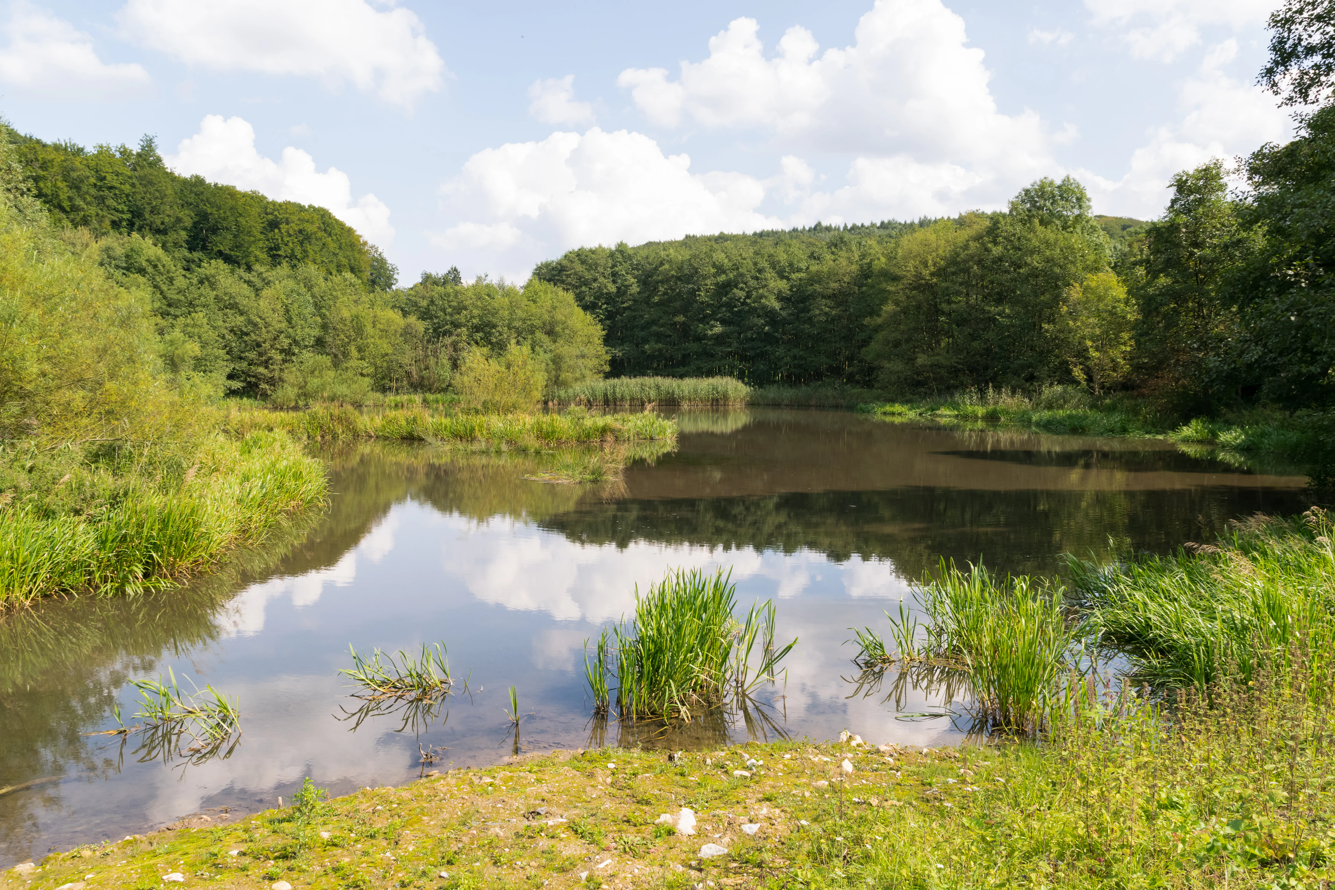
A peaceful pond reflecting a cloudy sky, surrounded by dense green forest and wetlands.
A tranquil pond surrounded by lush woodland and riparian vegetation within the nature reserve.

Marschallshagen und Nonnenholz mit oberem Altenautal history and protected-area timeline

The landscape around Marschallshagen und Nonnenholz has a long history of human use, evidenced most clearly by the medieval settlement of Marschallshagen itself, whose site is today overgrown and lies within the reserve. Forest clearance, grazing, and small-scale settlement have shaped the mosaic of woodland, grassland, hedges, and orchard meadows that characterize the area, while streams such as the Altenau and the Piepenbach have remained relatively undisturbed in their upper courses.

Modern protection began in 2002, when the Bezirksregierung Detmold designated the area as a Naturschutzgebiet under the key PB-057, recognizing its ecological value at regional level. By 2004 the conservation profile of the area was substantially strengthened through its inclusion in the European Natura 2000 network, both through the designation of the FFH site "Marschallshagen und Nonnenholz" under the EU Habitats Directive and through the larger bird protection area "Egge."

In 2014 the reserve was redesignated as part of the Lichtenau Landscape Plan adopted by the Paderborn district council. This redesignation confirmed the protected status of the area and aligned its boundaries and management framework with the broader landscape planning of the district, while leaving its core ecological character intact. Today the reserve stands as one of the most important areas within the Paderborn district's protected-area system and a meaningful component of the European Natura 2000 network.

Marschallshagen und Nonnenholz mit oberem Altenautal landscape and geographic character

The protected landscape is defined by an interplay between broad forested uplands and clearly carved stream valleys. On the higher ground, continuous blocks of beech forest cover much of the reserve, presenting an enclosed, gentle-canopy woodland character typical of the Westphalian uplands. The forest mantle opens along the valleys of the Altenau and the Piepenbach into long, narrow corridors of meadow, wetland, and floodplain woodland that cut through the wooded massif.

Along these stream corridors, near-natural stretches of running water are flanked by alder-ash floodplain forest and softwood floodplain woodland in the most frequently flooded zones. Small mires, reedbeds, sedge stands, and tall herb fringes add texture to the valley edges, while scattered natural rock outcrops break through the woodland on the slopes. The result is a layered landscape in which closed forest, semi-open woodland margins, and open valley grassland alternate over short distances.

Human elements are woven into this natural setting in subtle ways. Orchard meadows, hedgerows, solitary tree groups, and pollarded trees line some of the grassland patches, and the overgrown site of the former settlement of Marschallshagen sits quietly within the reserve as a reminder of the area's rural past. Together these features create a landscape that feels both ecologically rich and culturally layered, without dramatic relief but with strong ecological and visual variety.

Marschallshagen und Nonnenholz mit oberem Altenautal ecosystems, habitats, and plant life

Ecologically, the reserve belongs to the deciduous broadleaf forest zone of central Europe, with beech-dominated woodland as its central habitat. The beech forests here are not uniform but include two clearly defined communities: Waldmeister beech forest on more base-rich, mull-rich soils, and Hainsimsen beech forest on more acidic substrates. This division reflects local differences in geology and soil and supports a corresponding diversity of ground flora within the forest.

The valley systems associated with the upper Altenau and the Piepenbach introduce a contrasting set of habitats. Their near-natural courses, springs, and headwater stretches are accompanied by alder-ash floodplain forest and softwood floodplain woodland, while small mires, reedbeds, sedge communities, and tall herb fringes occupy wet depressions along and between the streams. Small standing waters, both natural and near-natural, add still-water elements to this wetland mosaic.

On the more open land, the reserve contains orchard meadows, hedgerows, scattered tree groups, and pollarded trees, which together create transitional habitats between forest and open country. Natural rock outcrops provide additional microhabitats for specialized flora and fauna. This combination of extensive beech forest, mosaic floodplain and wetland habitats, and semi-open cultural landscape gives the area a high overall ecological diversity within a relatively compact territory.

Marschallshagen und Nonnenholz mit oberem Altenautal wildlife and species highlights

Wildlife value in the reserve is closely linked to its forested character and its network of near-natural streams and valley wetlands. The mix of mature beech forest, floodplain woodland, and open wetland habitats supports a rich community of woodland and wetland birds, several of which are of conservation concern in Germany. Recorded breeding or regularly occurring species include kingfisher, black stork, middle spotted woodpecker, black woodpecker, grey-headed woodpecker, red kite, red-backed shrike, Tengmalm's owl, and great grey shrike.

The presence of these species reflects the structural quality of the habitats: old and decaying trees within the beech forests support cavity-nesting woodpeckers and owls, while the wooded streams with overhanging banks and clean water provide hunting habitat for kingfisher and shelter for black stork. The combination of closed canopy forest, semi-open valley clearings, hedgerow networks, and wetland fringes offers a particularly favorable set of nesting and foraging conditions across the reserve.

The wet habitats also contribute to a broader fauna of amphibians, invertebrates, and wetland-dependent species that depend on the near-natural course of the Altenau and Piepenbach and on the reserve's mires and small standing waters. Although specific species inventories are not detailed in the available source material, the habitat structure clearly supports a diverse and ecologically meaningful fauna typical of well-conserved Central European forest-stream landscapes.

Marschallshagen und Nonnenholz mit oberem Altenautal conservation status and protection priorities

The reserve is significant for conservation at multiple levels. At the regional level it is one of the largest and most important nature reserves in the Paderborn district, second only in size within the district and serving as a stronghold for species-rich beech forest habitat and near-natural stream valleys. Its 2002 designation and 2014 confirmation under the Lichtenau Landscape Plan reflect sustained recognition of its ecological value by both the Detmold regional government and the Paderborn district administration.

At the European level, the reserve sits firmly within the Natura 2000 network. The bulk of its area coincides with the FFH site "Marschallshagen und Nonnenholz" under the EU Habitats Directive, while the broader landscape also falls within the European bird protection area "Egge." Together these designations highlight the reserve's role in protecting habitat types and species of European interest, particularly beech forest communities, alluvial and wetland habitats, and a set of breeding bird species of conservation concern.

In practical terms, the conservation value of the area depends on maintaining the near-natural condition of its streams, the integrity of its beech and floodplain forests, and the careful management of its open and semi-open habitats such as orchard meadows and reedbeds. Because much of the reserve is forested and many of its streams flow in near-natural courses, the area also represents an important refuge of relatively undisturbed habitat in an otherwise heavily modified Westphalian landscape.

Marschallshagen und Nonnenholz mit oberem Altenautal cultural meaning and human context

The reserve contains a notable cultural-historical element in the site of the former settlement of Marschallshagen, a medieval village that has long since been abandoned and is today overgrown within the protected area. This historical feature, together with elements such as orchard meadows, hedgerows, tree groups, and pollarded trees scattered across the grassland zones, reflects centuries of rural land use in the region and the gradual transformation of cultivated countryside back into woodland.

At the regional planning level, parts of the area are recognized as a culturally significant landscape. The LWL GeodatenKultur database of the Landschaftsverband Westfalen-Lippe lists the wider area of Nonnenholz, Marschallshagen, and Blankenrode as a regionally important cultural landscape, reflecting the combined natural and historical value of the area. This recognition underscores that the reserve is not only an ecological site but also a landscape with a layered human history, from medieval settlement to modern conservation designation.

Top sights and standout views in Marschallshagen und Nonnenholz mit oberem Altenautal

The reserve stands out for the size and continuity of its beech forest cover, which includes both Waldmeister and Hainsimsen beech forest communities, and for the natural quality of its stream valleys. The upper Altenau and Piepenbach valleys run through the protected area in near-natural condition and are lined by alder-ash and softwood floodplain woodland, creating a strong ecological transition from forest to wetland.

It is also notable for its layered conservation status. The area protects habitat types under the EU Habitats Directive through its FFH site and supports breeding populations of several conservation-relevant bird species through its inclusion in the larger "Egge" bird protection area. The combination of these designations makes it a regionally distinctive site where national-level nature protection, European habitat protection, and European bird protection overlap.

Best time to visit Marschallshagen und Nonnenholz mit oberem Altenautal

The reserve is primarily a low-impact landscape for quiet nature observation rather than a tourism-oriented site, and its character shifts gradually with the seasons rather than opening or closing dramatically. Spring and early summer are often the most rewarding periods for visitors interested in woodland birds breeding in the beech forests and along the streams, when species such as woodpeckers, red kite, and warblers are most active and the deciduous canopy is still relatively open underneath.

Late spring and early summer also bring out the ground flora of the beech forests, including the characteristic species associated with Waldmeister and Hainsimsen beech forest communities, while the wetland fringes develop tall herb fringes and reed stands. Summer visits highlight the greenland valleys in full leaf and the rich insect life around the streams. Autumn turns the beech forest into a broader palette of yellows and browns and is a calm period for walking and observation; winter, when foliage is gone, opens up long views through the forest and along the valleys, though wildlife observation is then more focused on resident species and winter visitors.

Monthly climate preview

Long-term representative point measurements tracking monthly temperature and precipitation variation across the terrain

Marschallshagen und Nonnenholz mit oberem Altenautal Climate Normals and Annual Temperature Rhythm

Representative coordinates record measured multi-year temperature ranges alongside steady monthly precipitation distribution throughout the year. Reviewing the complete twelve-month climatology dataset clarifies long-term thermal shifts and moisture patterns mapped across the protected terrain.
Annual mean9 °C
0 °C18 °C
Jan
Feb
Mar
Apr
May12°
Jun15°
Jul18°
Aug18°
Sep14°
Oct
Nov
Dec
Warmest month
July

18 °C

Coolest month
January

-0.2 °C

Wettest month
July

2.6 mm/day

Driest month
April

1.7 mm/day

Park location guide

Geography guide, regional context, and park location map for Marschallshagen und Nonnenholz mit oberem Altenautal

Marschallshagen und Nonnenholz mit oberem Altenautal park geography, regions, and map view in Germany

Understand where Marschallshagen und Nonnenholz mit oberem Altenautal sits in Germany through a broader geographic reading of the surrounding landscape, nearby location context, and its mapped position within the national park landscape.

How Marschallshagen und Nonnenholz mit oberem Altenautal fits into Germany

Germany is a federal republic in Western and Central Europe with a population of over 83 million across sixteen constituent states. It is Europe's largest economy by nominal GDP and a major global exporter and importer. The capital is Berlin, and the country borders Denmark, Poland, Czech Republic, Austria, Switzerland, France, Luxembourg, Belgium, and the Netherlands.

Wider geography shaping Marschallshagen und Nonnenholz mit oberem Altenautal in Germany

Germany is located in Western and Central Europe, spanning 357,022 km². It borders Denmark to the north, Poland and the Czech Republic to the east, Austria and Switzerland to the south, and France, Luxembourg, Belgium, and the Netherlands to the west. The country has coastlines on the Baltic Sea and North Sea to the north, with the Alps located in the southern region.

Map view of Marschallshagen und Nonnenholz mit oberem Altenautal

Use this park location map to pinpoint Marschallshagen und Nonnenholz mit oberem Altenautal in Germany, understand its exact geographic position, and read its mapped placement within the surrounding landscape more clearly.

Pigeon | © OpenStreetMap contributors

Visual exploration of beech forests, stream valleys, and protected habitats

Marschallshagen und Nonnenholz mit oberem Altenautal Photos and Landscape Scenery

Visual records reveal the continuous beech forest uplands and carved stream corridors defining the protected terrain. Photographic documentation helps interpret the ecological mosaic of floodplain woodlands and valley wetlands across the reserve.

A peaceful pond reflecting a cloudy sky, surrounded by dense green forest and wetlands.

A wide landscape view of a vibrant green meadow surrounded by dense forests under a cloudy blue sky.

Park atlas

Compare adjacent Westphalian forest reserves, stream valleys, and regional conservation landscapes.

Parks Near Marschallshagen und Nonnenholz mit oberem Altenautal and Related Protected Areas

Browsing other protected areas near Marschallshagen und Nonnenholz mit oberem Altenautal reveals connected woodland corridors and similar upland habitats across the region. Expanding the geographic comparison highlights broader conservation networks and shared ecological traits throughout the surrounding territory.
A soft watercolor painting depicting a meandering stream through a grassy valley with rolling, tree-covered hills in the background.
Nature reserveNorth Rhine-Westphalia
About 4.3 km away#1 closest

East

Schwarzbachtal (PB): A Protected Stream Valley Landscape in North Rhine-Westphalia

Mapped nature reserve and valley habitat geography

Spanning over 200 hectares in the Paderborn district, Schwarzbachtal (PB) is a core nature reserve that protects the delicate stream valley landscape of the Schwarzbach. This area serves as a significant example of long-term conservation management in North Rhine-Westphalia, offering structured insight into regional habitat patterns and valley topography.

Area
2.206 km²
Established
2014
IUCN
IV
A soft watercolor painting showing a panoramic view of rolling hills and undulating green and pink landscape features against a pale sky.
Nature reserveWaldeck-Frankenberg
About 8.2 km away#2 closest

South

Naturschutzgebiet Büchenberg und Platzberg bei Hesperinghausen: Geography and Protected Landscapes

A study of limestone slopes and calcareous grassland habitats

This protected area in Waldeck-Frankenberg serves as a key site for calcareous dry grasslands and rare orchid species. The terrain features a striking mosaic of steep Zechstein limestone slopes, rock outcrops, and moisture-rich meadow patches. Analyzing the area reveals how small, traditionally managed reserves can maintain high biodiversity and provide essential connectivity within the Diemeltal regional landscape.

Area
0.418 km²
Established
1993
Relief
Upland
Climate
Temperate
A soft watercolor painting of a serene landscape featuring a small pond in the foreground with gentle hills and trees in the background.
Protected landscapeKreis Paderborn
About 9.6 km away#3 closest

Northwest

Landschaftsschutzgebiet Büren: A Detailed Look at the Protected Rural Mosaic of Kreis Paderborn

Mapped protected landscapes in the German Westphalian countryside

Landschaftsschutzgebiet Büren spans a wide, undulating terrain in the Kreis Paderborn district, characterized by its durable structure of woodland patches, hedgerows, and headwater springs. The area serves as a key case study in maintaining semi-natural ecological features within an active, working agricultural landscape. Access detailed geographic context on the patterns of this regional protected area and its role in the Westphalian landscape.

Area
142.95 km²
Established
1974
Relief
Mixed relief
Scope
Terrestrial
A soft, horizontal watercolor painting showing a winding stream flowing through a green valley with gentle hills and trees in the background.
Nature reserveNordrhein-Westfalen
About 12 km away#4 closest

North

Naturschutzgebiet Schmittwassertal: A Protected Nature Reserve in the Paderborn District

Mapping brook corridors and calcareous grassland landscapes in Westphalia.

Naturschutzgebiet Schmittwassertal represents a fragmented yet ecologically vital nature reserve in Nordrhein-Westfalen. The area encompasses 53.6 hectares of stream-cut valleys and limestone-influenced slopes. This atlas entry details the mosaic of habitats ranging from alder-lined brook corridors to nutrient-poor Borstgrasrasen and semi-dry calcareous grasslands, highlighting its function as a connected biological corridor.

Area
0.536 km²
Established
2014
Relief
Upland
Climate
Temperate
A horizontal watercolor painting of a calm lake surrounded by a pine forest and rolling hills under a soft light.
Protected landscapeKreis Paderborn
About 13 km away#5 closest

Southwest

Landschaftsschutzgebiet FFH-Gebiet Fürstenberger Wald: Protected Area and Forest Geography

A woodland conservation landscape in the Kreis Paderborn foothills

This protected area features a cohesive block of old-growth beech forest, enriched by significant deadwood habitats and a dense internal network of brooks. Located within the Kreis Paderborn administrative district, the landscape serves as a key ecological connector in the eastern Sauerland, balancing moist valley meadows with upland forest ridges and ongoing deciduous forest restoration efforts.

Area
14.925 km²
Established
2007
Relief
Upland
Climate
Temperate
Watercolor illustration of rolling green and pink-tinted hills with scattered small trees against a white background.
Nature reserveNordrhein-Westfalen
About 13 km away#6 closest

Northeast

Kalktriften Willebadessen Nature Reserve: Mapped Geography and Protected Limestone Grasslands

Protected calcareous slopes within the Nethe valley region

Kalktriften Willebadessen encompasses a unique Muschelkalk limestone ridge in the Weser Uplands. This protected nature reserve provides a essential habitat for threatened flora and fauna, thriving within an open, sun-baked landscape that contrasts sharply with the surrounding forests. The site serves as a key example of how historical agricultural practices sustain biodiversity, featuring varied terrain from steep southern spurs to panoramic valley overlooks.

Area
1.12 km²
Established
2003
IUCN
IV
Relief
Upland
A soft watercolor illustration of rolling green hills, a cluster of trees, and distant low mountains in muted pastel tones.
Protected landscapeHochsauerlandkreis
About 14 km away#7 closest

South

Landschaftsschutzgebiet Freiflächen um Erlinghausen / Auf der Sandkuhle: Protected Area Map

A regional landscape conservation zone in Hochsauerlandkreis

This protected landscape encompasses 548 hectares of rural terrain surrounding Erlinghausen. It is defined by its traditional agricultural matrix, orchard meadows, and cultural heritage features that maintain the historic character of the eastern Sauerland foothills.

Area
5.487 km²
Established
2008
Relief
Upland
Scope
Terrestrial
A horizontal watercolor painting showing rolling, abstract hills with patches of green, yellow, and soft red, accented with stylized coniferous forest lines.
Nature reserveNordrhein-Westfalen
About 15 km away#8 closest

West

Leiberger Wald Nature Reserve: Protected Woodland and Stream Geography in Paderborn

A mapped forest complex within the Nordrhein-Westfalen landscape

Leiberger Wald encompasses an extensive series of beech forests and riparian habitats that form a key protected node in the Kreis Paderborn. As a significant nature reserve, the area supports a wide range of woodland and aquatic species, serving as a critical refuge within the broader ecological network of western Germany.

Area
17.86 km²
Established
1994
IUCN
IV

Common questions about visiting, size, designation, and location context for Marschallshagen und Nonnenholz mit oberem Altenautal

Marschallshagen und Nonnenholz mit oberem Altenautal FAQs for park facts, access, geography, and protected area context

Find quick answers about Marschallshagen und Nonnenholz mit oberem Altenautal, including protected-area facts, park geography, trail and visitor context, and how the park fits into its surrounding country and regional landscape.
MoriAtlas Explorer

Continue Your Protected Areas Search Across the Global Atlas

Deepen your exploration by continuing the structured search for national parks and protected areas worldwide. Utilize the comprehensive filtering capabilities to compare different conservation landscapes and refine your understanding of global park geography. Discover more about the distribution and characteristics of protected natural areas.

Global natural geography