
Mori Atlas logo
Nature reserveNaturschutzgebiet Büchenberg und Platzberg bei Hesperinghausen

Mapping the calcareous dry grasslands and unique microclimates of this German conservation landscape

Naturschutzgebiet Büchenberg und Platzberg bei Hesperinghausen: A Limestone Nature Reserve in Waldeck-Frankenberg

Naturschutzgebiet Büchenberg und Platzberg bei Hesperinghausen is a notable nature reserve situated on the steep Zechstein limestone slopes above the Diemeltal. Positioned along the border between Hesse and North Rhine-Westphalia, the site protects a complex mosaic of calcareous dry grasslands, limestone scree, and spring-fed flushes. Through this geographic record, examine the varied terrain and habitat diversity that support a specialized botanical community, including rare orchids and regionally significant insect populations.

calcareous grasslandKalkmagerrasenorchid habitatlimestone slopesZechsteindiemeltal
A flat, minimalist digital illustration showing a hilly landscape with conifer trees, limestone cliffs in the background, and a pastel sunset sky.

Naturschutzgebiet Büchenberg und Platzberg bei Hesperinghausen

Nature reserve

Park overview

Structured park overview, official facts, and landscape profile for Naturschutzgebiet Büchenberg und Platzberg bei Hesperinghausen

Naturschutzgebiet Büchenberg und Platzberg bei Hesperinghausen park facts, protected area profile, and essential visitor context

Review the core facts for Naturschutzgebiet Büchenberg und Platzberg bei Hesperinghausen, including designation, size, terrain, visitor scale, habitats, and operating context in one park-focused overview.

About Naturschutzgebiet Büchenberg und Platzberg bei Hesperinghausen

Naturschutzgebiet Büchenberg und Platzberg bei Hesperinghausen lies on the northern edge of the town area of Diemelstadt in the Waldeck-Frankenberg district, directly on the Hesse-North Rhine-Westphalia state border. The reserve is composed of four separate parcels arranged on differently exposed slopes, covering a compact area of steep Zechstein limestone terrain between the villages of Hesperinghausen and Helmighausen in Hesse and the North Rhine-Westphalian village of Westheim across the border.

The defining feature of the area is its complex of calcareous dry grasslands on Zechstein-derived geology. These grasslands belong phytosociologically to the Enzian-Fiederzwenken-Rasen, a semi-natural vegetation type associated with shallow, nutrient-poor, lime-rich soils that have been kept open by traditional land use rather than by forestry. The reserve's mosaic also includes limestone scree habitats, exposed rock with crevice vegetation, pioneer grasslands on very thin soils, small patches of wet meadow, and a calcareous spring flush. This combination of microhabitats within a relatively small area is the foundation of the site's botanical and zoological richness.

The reserve has been designated primarily because of its botanical significance. Seven orchid species have been recorded here, including visually prominent populations of Manns-Knabenkraut and Schlüsselblumen (cowslip-type primroses). Among the orchids, the reserve stands out for the presence of nationally threatened taxa such as Dreizähniges Knabenkraut and Fliegen-Ragwurz, as well as the conspicuous parasitic plant Große Sommerwurz.

Beyond the flora, the area supports a diverse insect fauna that reflects the warm microclimate of the slopes. Surveys have documented dozens of butterfly and burnet moth species, with several on the Hessian red list, and a community of grasshoppers including characteristic dry-grassland taxa such as Stenobothrus lineatus. Open-country breeding birds such as Dorngrasmücke and Baumpieper are joined by feeding visitors of conservation interest including Uhu and Grauspecht. Neuntöter is also recorded.

The reserve's character is deeply shaped by management. Since the 1980s, conservationists have worked to control scrub encroachment and discourage neglect-driven shrub invasion, and since the 1990s a sheep flock from Marsberg-Udorf has grazed the dry grasslands, helping maintain the open structure that sustains this flora and fauna. A surrounding Landschaftsschutzgebiet connects the four reserve parcels and links the protected area to the broader Diemeltal landscape.

Quick facts and research context for Naturschutzgebiet Büchenberg und Platzberg bei Hesperinghausen

Location: northern Hesse, Germany, in the Waldeck-Frankenberg district within the city area of Diemelstadt, immediately south of the border with North Rhine-Westphalia. Protected status: designated as a Naturschutzgebiet (nature reserve) in 1993 under the Regierungsbezirk Kassel; coincident with EU Habitats Directive site DE-4519-301. Habitat type: Zechstein limestone slopes with calcareous dry grasslands, scree, exposed rock, pioneer vegetation, wet meadows, and a limestone spring flush. Key ecological values: regionally important orchid-rich grassland, seven orchid species including nationally threatened taxa, 36 documented bird species, and a significant assemblage of butterflies, burnet moths, and grasshoppers. Management: grazing by a sheep flock from Marsberg-Udorf since the 1990s, with earlier scrub-cutting work by the Verein für Natur- und Vogelschutz im Hochsauerlandkreis.

Protection and recognition

Documented terrestrial protection scope and international recognition records

Naturschutzgebiet Büchenberg und Platzberg bei Hesperinghausen Protection Status

Terrestrial protection status data for Naturschutzgebiet Büchenberg und Platzberg bei Hesperinghausen outlines the recorded management scope and designation framework. Official records compile verified protection metrics to provide transparent baseline facts for each protected landscape.

Protection details

Protection scope
Terrestrial
Transboundary protection
No
Park context

Deeper park guide and search-rich context for Naturschutzgebiet Büchenberg und Platzberg bei Hesperinghausen

Naturschutzgebiet Büchenberg und Platzberg bei Hesperinghausen history, landscape, wildlife, and travel context

Explore Naturschutzgebiet Büchenberg und Platzberg bei Hesperinghausen through its history, landscape character, ecosystems, wildlife, conservation priorities, cultural context, and seasonal travel timing in a structured park guide built for atlas discovery and search intent.

Why Naturschutzgebiet Büchenberg und Platzberg bei Hesperinghausen stands out

The reserve is best known for its orchid-rich calcareous dry grasslands on steep Zechstein limestone slopes in the Diemeltal. Botanically, the area is a notable example of the Enzian-Fiederzwenken-Rasen (Gentian-Bromus) grassland type, hosting seven orchid species and populations of rare plants such as Dreizähniges Knabenkraut, Fliegen-Ragwurz, and the parasitic Große Sommerwurz. Faunistically, it is recognized as a regionally important insect site, with documented populations of butterflies, burnet moths, and grasshoppers, including species on the Hessian red list. Its combination of warm, sun-exposed slopes, traditional sheep grazing, and proximity to the Hesse-NRW border makes it a small but well-documented conservation anchor for the Diemeltal limestone landscape.
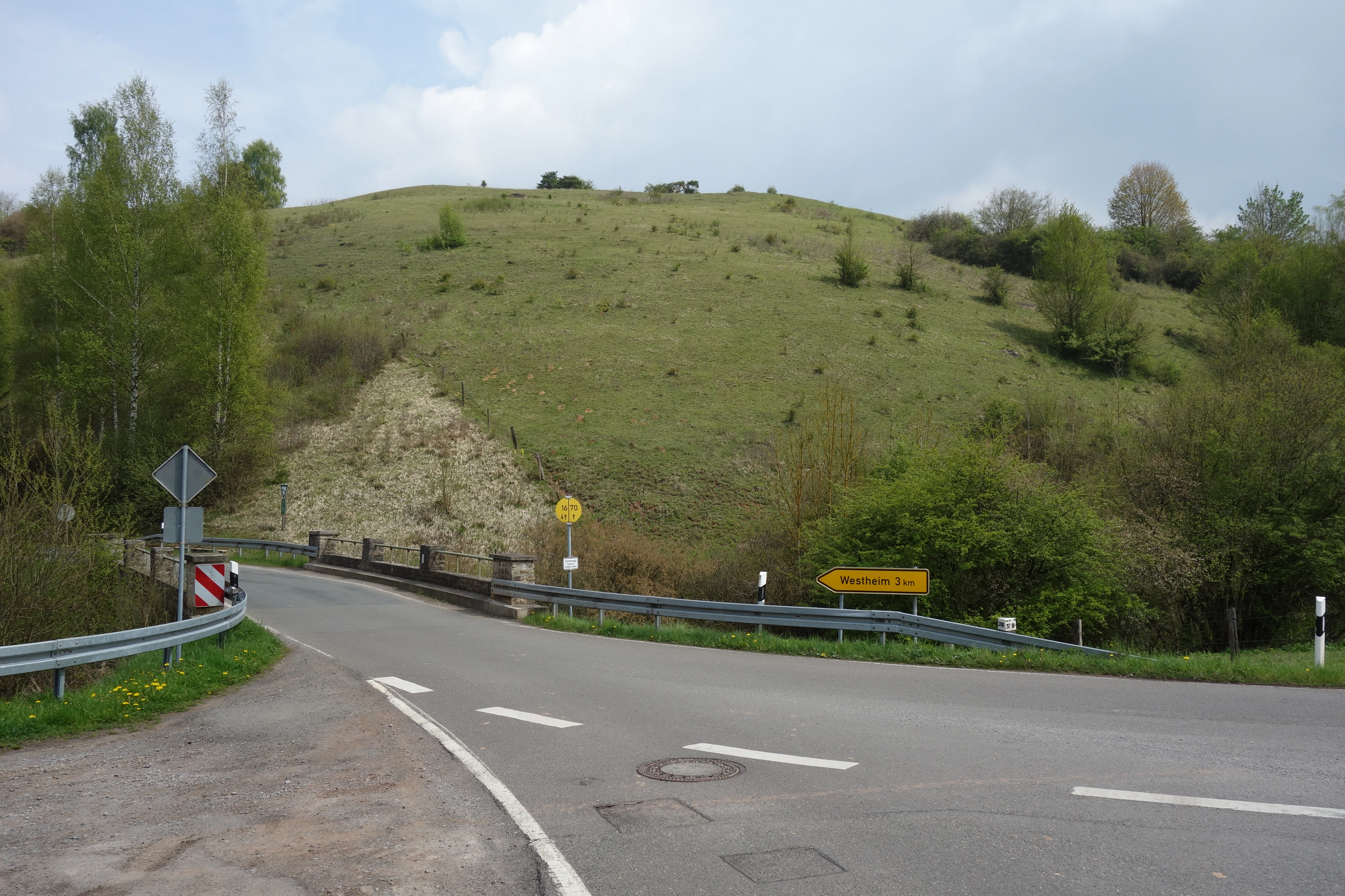
A paved road intersection in the foreground leads toward a large, grassy limestone hill rising in the background, typical of the nature reserve.
A view of the Büchenberg and Platzberg nature reserve with its characteristic limestone grassland slope, seen from a junction.

Naturschutzgebiet Büchenberg und Platzberg bei Hesperinghausen history and protected-area timeline

The area's modern conservation history began in the 1980s, when the Verein für Natur- und Vogelschutz im Hochsauerlandkreis (VNV) began carrying out habitat management on the steep limestone slopes around Hesperinghausen, focusing on countering encroachment by shrubs and bramble on the formerly open calcareous grasslands.

In 1993, the area was formally designated as a Naturschutzgebiet by Regierungsbezirk Kassel under the Hessian nature conservation framework, primarily because of its outstanding botanical value. At the same time, the surrounding landscape was designated as Landschaftsschutzgebiet Büchenberg und Platzberg bei Hesperinghausen, creating a buffer zone that connects the four separate parcels of the reserve.

Following designation, a sheep flock from Marsberg-Udorf was introduced to graze the dry grasslands, a traditional form of management that helps maintain the open character of the vegetation. The reserve is also identical with the EU Habitats Directive site Büchenberg und Platzberg bei Hesperinghausen (DE-4519-301), bringing it under the framework of Natura 2000 conservation.

Naturschutzgebiet Büchenberg und Platzberg bei Hesperinghausen landscape and geographic character

The landscape of the reserve is shaped by the steep slopes of the Diemeltal, where Zechstein limestone bedrock has weathered into a fractured terrain of rock outcrops, scree, and shallow soils. Four discrete parcels of the protected area occupy differently oriented hillsides, producing a patchwork of microclimates from cool, shaded north-facing slopes to warm, sun-exposed south- and west-facing grasslands.

The most visually distinctive features are the open calcareous grasslands stretching across the upper and middle slopes, where thin, lime-rich soils support a continuous sward of low-growing grasses, herbs, and orchids. Below these, limestone scree slopes transition into rock faces with crevice vegetation, while at the base of the slopes, small patches of wet meadow and a calcareous spring flush provide a contrasting, moisture-loving habitat. This compression of dry, mesic, and wet microhabitats into a very small area is one of the defining qualities of the landscape.

Beyond the reserve itself, the adjacent Kallental and the broader Diemeltal frame the sites, and the protected open slopes form a striking contrast to the closed forests and agricultural land that dominate the surrounding region.

Naturschutzgebiet Büchenberg und Platzberg bei Hesperinghausen ecosystems, habitats, and plant life

Ecologically, the reserve is a classic example of a small, well-managed limestone dry-grassland complex. The vegetation belongs to the Enzian-Fiederzwenken-Rasen, a phytosociological unit characterized by low productivity, high species richness, and strong dependence on continued grazing or mowing. Because the soils are shallow and lime-rich, they support a flora absent from more acidic or nutrient-rich habitats in the region.

Wetland elements, although occupying only small areas, add an important dimension to the ecological mosaic. Small wet meadows and a calcareous spring flush provide habitat for moisture-loving plants and invertebrates and contribute to hydrological diversity within an otherwise dry landscape. Exposed rock and scree habitats, meanwhile, host stress-tolerant crevice and pioneer vegetation that bridges the gap between bare rock and developed grassland.

The result is a habitat mosaic that, within its modest footprint, combines elements typical of much larger limestone landscapes, making the site ecologically disproportionate to its size.

Naturschutzgebiet Büchenberg und Platzberg bei Hesperinghausen wildlife and species highlights

The reserve has been documented as supporting a diverse invertebrate fauna typical of warm, dry calcareous grasslands. Surveys have recorded around 70 butterfly and related species, including roughly 35 day-flying butterfly species, with several listed on the Hessian red list. The grasshopper community includes about ten species, among them the red-listed short-winged bush-cricket Metrioptera brachyptera and Stenobothrus lineatus, which serves as a characteristic species of grazed dry grasslands on warm west-facing slopes.

The avifauna reflects the open, semi-dry nature of the terrain. Roughly 36 bird species have been recorded, with around half of these using the area for feeding. Notable breeding species in the bushy margins and rough grassland include Dorngrasmücke, Baumpieper, and Neuntöter, while larger species such as Uhu and Grauspecht use the area as a feeding ground rather than as primary breeding habitat. Together, the bird assemblage underlines the role of the site as a complement to surrounding forest and agricultural habitats in the Diemeltal.

Naturschutzgebiet Büchenberg und Platzberg bei Hesperinghausen conservation status and protection priorities

The site is a nature reserve of primarily botanical importance, designated in 1993 specifically for its exceptional value to the regional flora. Its conservation significance rests on three linked pillars: a rare and threatened vegetation type, a significant orchid community, and an unusual concentration of insect and bird diversity within a very small area.

Within the European framework, the reserve is identical to the Natura 2000 site FFH-Gebiet Büchenberg und Platzberg bei Hesperinghausen (DE-4519-301), placing it in the same legal and planning system as other EU-protected habitats in the Diemeltal. A landscape protection zone connects the four reserve parcels and helps buffer the central protected area from external land-use change.

Conservation management has been proactive rather than passive. Long-running scrub control work and the introduction of sheep grazing since the 1990s reflect the understanding that calcareous dry grasslands are not self-sustaining but require active intervention to keep woody species from reclaiming them. This management approach, together with the fact that seven orchid species (some nationally rare) occur here, gives the site an importance far above what its modest area would suggest.

Naturschutzgebiet Büchenberg und Platzberg bei Hesperinghausen cultural meaning and human context

The reserve's cultural context is rooted in the traditional land use of the Diemeltal, where steep limestone slopes have long been kept open through grazing by sheep rather than converted to arable land or forestry. This long historical association with transhumant and pastoral land use is reflected in the continued presence of the Marsberg-Udorf sheep flock, which has grazed the site since the 1990s.

The villages that frame the reserve, Hesperinghausen and Helmighausen on the Hesse side and Westheim on the North Rhine-Westphalia side, are all small historical communities within a rural landscape. The nature reserve itself was established through the engagement of regional conservation organizations, particularly the Verein für Natur- und Vogelschutz im Hochsauerlandkreis, which began habitat management there in the 1980s, illustrating a strong local stewardship tradition.

Top sights and standout views in Naturschutzgebiet Büchenberg und Platzberg bei Hesperinghausen

The standout features of Naturschutzgebiet Büchenberg und Platzberg bei Hesperinghausen are concentrated in a small space: Zechstein limestone slopes, orchid-rich Enzian-Fiederzwenken-Rasen calcareous dry grasslands, and a tight mosaic of scree, rock-outcrop, pioneer, and spring-fed habitats.

Its highlights also include the orchid flora, with seven species and nationally rare taxa such as Dreizähniges Knabenkraut and Fliegen-Ragwurz; the invertebrate community, including red-listed butterflies, burnet moths, and grasshoppers; and the open-country bird assemblage featuring Neuntöter, Uhu, and Grauspecht. Long-term sheep grazing and scrub-control management complete the picture of a small but intensively cared-for conservation site.

Best time to visit Naturschutzgebiet Büchenberg und Platzberg bei Hesperinghausen

The reserve is best appreciated in late spring and early summer, when the calcareous grasslands are at their peak bloom and the orchids, including the conspicuous Manns-Knabenkraut and Schlüsselblumen, are flowering. This period also coincides with peak butterfly and burnet moth activity on the warm slopes.

Late spring to midsummer is also a good time for bird observation along the bushy margins, where species such as Neuntöter and Dorngrasmücke are active. Outside the flowering season, the value of the site for casual visitors is lower, as much of its interest is botanical and entomological.


Monthly climate preview

Long term temperature and monthly precipitation averages across the protected area

Naturschutzgebiet Büchenberg und Platzberg bei Hesperinghausen Climate and Weather Normals

Representative climate data from 1991 to 2020 documents the measured annual temperature rhythm and steady monthly precipitation patterns at this protected location. Examining the complete twelve month profile provides deeper baseline measurements for researchers evaluating regional environmental conditions.
Annual mean9 °C
0 °C18 °C
Jan
Feb
Mar
Apr
May12°
Jun15°
Jul18°
Aug18°
Sep14°
Oct
Nov
Dec
Warmest month
July

18 °C

Coolest month
January

-0.2 °C

Wettest month
July

2.6 mm/day

Driest month
April

1.7 mm/day

Park location guide

Geography guide, regional context, and park location map for Naturschutzgebiet Büchenberg und Platzberg bei Hesperinghausen

Naturschutzgebiet Büchenberg und Platzberg bei Hesperinghausen park geography, regions, and map view in Germany

Understand where Naturschutzgebiet Büchenberg und Platzberg bei Hesperinghausen sits in Germany through a broader geographic reading of the surrounding landscape, nearby location context, and its mapped position within the national park landscape.

How Naturschutzgebiet Büchenberg und Platzberg bei Hesperinghausen fits into Germany

Germany is a federal republic in Western and Central Europe with a population of over 83 million across sixteen constituent states. It is Europe's largest economy by nominal GDP and a major global exporter and importer. The capital is Berlin, and the country borders Denmark, Poland, Czech Republic, Austria, Switzerland, France, Luxembourg, Belgium, and the Netherlands.

Wider geography shaping Naturschutzgebiet Büchenberg und Platzberg bei Hesperinghausen in Germany

Germany is located in Western and Central Europe, spanning 357,022 km². It borders Denmark to the north, Poland and the Czech Republic to the east, Austria and Switzerland to the south, and France, Luxembourg, Belgium, and the Netherlands to the west. The country has coastlines on the Baltic Sea and North Sea to the north, with the Alps located in the southern region.

Map view of Naturschutzgebiet Büchenberg und Platzberg bei Hesperinghausen

Use this park location map to pinpoint Naturschutzgebiet Büchenberg und Platzberg bei Hesperinghausen in Germany, understand its exact geographic position, and read its mapped placement within the surrounding landscape more clearly.

Pigeon | © OpenStreetMap contributors

Location context for Naturschutzgebiet Büchenberg und Platzberg bei Hesperinghausen

HessenWaldeck-Frankenberg

Visualizing steep limestone slopes, calcareous dry grasslands, and rare orchid habitats

Naturschutzgebiet Büchenberg und Platzberg bei Hesperinghausen Photos and Landscapes

Photographic documentation reveals the rugged Zechstein terrain, exposed rock outcrops, and complex microclimates shaping the protected Diemeltal landscape. Visual exploration of these steep limestone hillsides provides deeper insight into the rare plant communities and specialized habitats harbored within the reserve.

A paved road intersection in the foreground leads toward a large, grassy limestone hill rising in the background, typical of the nature reserve.

A wide view of a grassy, hilly landscape in Germany, featuring scattered shrubs and coniferous trees on a gentle slope under an overcast sky.

Park atlas

Compare nearby protected landscapes, Zechstein limestone reserves, and regional habitats

Other Parks Near Naturschutzgebiet Büchenberg und Platzberg bei Hesperinghausen

Browse protected areas and natural reserves located near Naturschutzgebiet Büchenberg und Platzberg bei Hesperinghausen to compare regional limestone topography. Expanding the geographic scope helps trace connected conservation terrain across the surrounding landscape.
A soft watercolor illustration of rolling green hills, a cluster of trees, and distant low mountains in muted pastel tones.
Protected landscapeHochsauerlandkreis
About 5.6 km away#1 closest

South

Landschaftsschutzgebiet Freiflächen um Erlinghausen / Auf der Sandkuhle: Protected Area Map

A regional landscape conservation zone in Hochsauerlandkreis

This protected landscape encompasses 548 hectares of rural terrain surrounding Erlinghausen. It is defined by its traditional agricultural matrix, orchard meadows, and cultural heritage features that maintain the historic character of the eastern Sauerland foothills.

Area
5.487 km²
Established
2008
Relief
Upland
Scope
Terrestrial
A soft watercolor painting depicting a meandering stream through a grassy valley with rolling, tree-covered hills in the background.
Nature reserveNorth Rhine-Westphalia
About 7.4 km away#2 closest

North

Schwarzbachtal (PB): A Protected Stream Valley Landscape in North Rhine-Westphalia

Mapped nature reserve and valley habitat geography

Spanning over 200 hectares in the Paderborn district, Schwarzbachtal (PB) is a core nature reserve that protects the delicate stream valley landscape of the Schwarzbach. This area serves as a significant example of long-term conservation management in North Rhine-Westphalia, offering structured insight into regional habitat patterns and valley topography.

Area
2.206 km²
Established
2014
IUCN
IV
A horizontal watercolor painting showing a soft landscape with a winding stream, grassy meadows, and distant forested hills under a pale sky.
Nature reserveGermany
About 8.2 km away#3 closest

North

Marschallshagen und Nonnenholz mit oberem Altenautal Protected Nature Reserve Map

Ecological landscape and forest geography in the Paderborn district

Covering approximately 1,943 hectares, this nature reserve is a major component of the regional conservation framework. The landscape creates a layered mosaic of closed beech forest, near-natural running water, and floodplain woodland, serving as a significant site for European bird protection programs.

Area
19.43 km²
Established
2002
A horizontal watercolor painting of a calm lake surrounded by a pine forest and rolling hills under a soft light.
Protected landscapeKreis Paderborn
About 9.3 km away#4 closest

West

Landschaftsschutzgebiet FFH-Gebiet Fürstenberger Wald: Protected Area and Forest Geography

A woodland conservation landscape in the Kreis Paderborn foothills

This protected area features a cohesive block of old-growth beech forest, enriched by significant deadwood habitats and a dense internal network of brooks. Located within the Kreis Paderborn administrative district, the landscape serves as a key ecological connector in the eastern Sauerland, balancing moist valley meadows with upland forest ridges and ongoing deciduous forest restoration efforts.

Area
14.925 km²
Established
2007
Relief
Upland
Climate
Temperate
Watercolor painting of a wide, soft-toned landscape showing gentle rolling hills, open fields, and a small meandering stream, executed in a minimalist, light-filled style.
Protected landscapeHochsauerlandkreis
About 9.8 km away#5 closest

Southwest

Landschaftsschutzgebiet Freiflächen um Giershagen: Protected Landscape and Regional Map

Agricultural cultural heritage and biodiversity in Hochsauerlandkreis

This protected area in North Rhine-Westphalia preserves 785 hectares of traditional Sauerland countryside. It features extensively managed farmland, rare arable plant habitats, and historically significant landscape structures that support regional biodiversity and long-term ecological stewardship.

Area
7.849 km²
Established
2008
Relief
Upland
Scope
Terrestrial
A horizontal watercolor illustration of a soft, hazy valley with rolling green hills, distant treelines, and wildflowers in the foreground.
Nature reserveNorth Rhine-Westphalia
About 12 km away#6 closest

Southwest

Naturschutzgebiet Aabachtal Nature Reserve and Sauerland Protected Stream Valley Geography

A preserved fluvial landscape in North Rhine-Westphalia

Naturschutzgebiet Aabachtal is a protected nature reserve in the northern Sauerland of North Rhine-Westphalia. Centered on the Aabach stream, it protects a classic Mittelgebirge valley landscape defined by meandering watercourses, lush floodplain meadows, and deciduous forest slopes, serving as a critical habitat for specialized moisture-loving flora and diverse riparian fauna.

Area
0.716 km²
Established
2001
Relief
Upland
Scope
Terrestrial
A soft watercolor illustration showing a gentle, rolling landscape with green meadows, trees, and distant hills under a pale sky.
Nature reserveHochsauerlandkreis
About 13 km away#7 closest

Southwest

Naturschutzgebiet Östlicher Arnstein: Protected Nature Reserve and Geographic Map

Grassland mosaic and historic terrain in Hochsauerlandkreis

Naturschutzgebiet Östlicher Arnstein comprises 8.5 hectares of species-rich meadows and hedgerow complexes nestled in the Waldecker Gefilde. This reserve offers a significant look at regional grassland conservation, providing habitat diversity through its base-rich soils and disused quarry sites. It acts as a vital transition point between the forested Sauerland slopes and the surrounding open agricultural landscape.

Area
0.085 km²
Established
2001
Relief
Lowland
Climate
Temperate
A watercolor landscape illustration showing soft, rolling green hills, coniferous trees, and a hazy background.
Nature reserveHochsauerlandkreis
About 14 km away#8 closest

Southwest

Naturschutzgebiet Padberg: A Protected Landscape in the Hochsauerlandkreis Region

Diabas geology and forest habitat mapping

Naturschutzgebiet Padberg protects a compact but ecologically rich landscape of beech forests and craggy rock cliffs. Its position above the Diemel valley highlights the relationship between volcanic Diabas topography and woodland development within the Hochsauerlandkreis district.

Area
0.467 km²
Established
2001
Relief
Upland
Climate
Temperate

Common questions about visiting, size, designation, and location context for Naturschutzgebiet Büchenberg und Platzberg bei Hesperinghausen

Naturschutzgebiet Büchenberg und Platzberg bei Hesperinghausen FAQs for park facts, access, geography, and protected area context

Find quick answers about Naturschutzgebiet Büchenberg und Platzberg bei Hesperinghausen, including protected-area facts, park geography, trail and visitor context, and how the park fits into its surrounding country and regional landscape.
MoriAtlas Explorer

Continue Your Protected Areas Search Across the Global Atlas

Deepen your exploration by continuing the structured search for national parks and protected areas worldwide. Utilize the comprehensive filtering capabilities to compare different conservation landscapes and refine your understanding of global park geography. Discover more about the distribution and characteristics of protected natural areas.

Global natural geography