
Mori Atlas logo
Nature reserveNaturschutzgebiet Östlicher Arnstein

Geographic context and boundary overview for this protected nature reserve in Hochsauerlandkreis.

Naturschutzgebiet Östlicher Arnstein: A Protected Mosaic of Grassland and Historic Quarries

Naturschutzgebiet Östlicher Arnstein functions as a critical refugium within the Waldecker Gefilde, protecting a rare mosaic of base-rich meadows, hedgerows, and historic quarries. Located within the Hochsauerlandkreis district of Germany, this 8.5-hectare reserve preserves essential meadow flora and fauna at the transition between forested hills and open agricultural terrain. The protected area now serves as a key component of the wider Diemel and Hoppecke valleys bird protection network.

grassland reservespecies-rich meadowshedgerow mosaiccalcareous grasslandsheep pastureformer quarries
A digital vector-style illustration of a waterfall plunging over a steep cliff face into a river below, surrounded by rolling hills and coniferous trees under a soft-toned sky.

Naturschutzgebiet Östlicher Arnstein

Nature reserve

Park overview

Structured park overview, official facts, and landscape profile for Naturschutzgebiet Östlicher Arnstein

Naturschutzgebiet Östlicher Arnstein park facts, protected area profile, and essential visitor context

Review the core facts for Naturschutzgebiet Östlicher Arnstein, including designation, size, terrain, visitor scale, habitats, and operating context in one park-focused overview.

About Naturschutzgebiet Östlicher Arnstein

Naturschutzgebiet Östlicher Arnstein is a compact nature reserve dedicated to the protection of species-rich grassland in the northern Sauerland. The site occupies roughly 8.5 hectares northwest of the village of Giershagen within the town of Marsberg, and was formally protected in 2001 through the Hoppecketal landscape plan drawn up by Hochsauerlandkreis. Its conservation purpose focuses on preserving a heterogeneous mix of calcareous-influenced grassland and structurally rich hedgerows in an area where the eastern side opens into arable farmland and the western side gives way to the larger forest landscape around the Arnstein hills.

The reserve's core consists of two main habitat blocks. In the northern part, a livestock pasture is surrounded by a hedgerow complex, while the central and southern parts hold a more intensively used hay meadow that gradually transitions into sheep-grazed pasture and scattered thicker scrub. Within the hedgerow areas sit two small and now disused quarries, providing unusual micro-topography, exposed substrate, and additional habitat structure. A small Christmas-tree plantation that existed inside the reserve at the time of designation has since been removed and the area converted back to grassland.

Because the site lies in a larger agricultural region where nutrient-rich, high-input farming dominates, its combination of unfertilized meadows and intact hedgerow networks gives it outsized ecological importance. The protected area continues to be managed through extensive grazing and mowing without fertilization, in line with its landscape plan objectives. Together with the neighbouring forested reserve of Südlicher Arnstein and the surrounding landscape protection areas, it contributes to a wider network of protected habitats spanning the Hoppecke, Diemel, and Freiflächen around Giershagen landscape zones, and since 2023 has been incorporated into the Diemel- und Hoppecketal bird protection area.

Quick facts and research context for Naturschutzgebiet Östlicher Arnstein

The reserve covers around 8.5 hectares and lies northwest of Giershagen, part of the municipality of Marsberg in Hochsauerlandkreis. It was established as a nature reserve (Naturschutzgebiet) in 2001 under the Hoppecketal landscape plan. The protected land consists mainly of species-poor to moderately species-rich meadows, sheep-grazed pasture, hedgerow complexes, and two small disused quarries. Since 2023 it has formed part of the EU-level Diemel- und Hoppecketal bird protection area, and it borders the Südlicher Arnstein forest reserve to the southwest.

Protection and recognition

Documented terrestrial protection scope and international recognition data

Naturschutzgebiet Östlicher Arnstein Protection Status and Designation Records

Terrestrial protection status records for Naturschutzgebiet Östlicher Arnstein outline the established management scope and conservation parameters. Official designation details clarify the formal administrative framework governing this protected natural landscape.

Protection details

Protection scope
Terrestrial
Transboundary protection
No
Park context

Deeper park guide and search-rich context for Naturschutzgebiet Östlicher Arnstein

Naturschutzgebiet Östlicher Arnstein history, landscape, wildlife, and travel context

Explore Naturschutzgebiet Östlicher Arnstein through its history, landscape character, ecosystems, wildlife, conservation priorities, cultural context, and seasonal travel timing in a structured park guide built for atlas discovery and search intent.

Why Naturschutzgebiet Östlicher Arnstein stands out

Its protected mosaic of base-rich, herb-rich meadows combined with hedgerow and scrub complexes, which together serve as a refuge for the characteristic flora and fauna of low-intensity grassland in the Waldecker Gefilde. The reserve is also notable for two small former quarries that add topographic and habitat diversity to the open landscape.
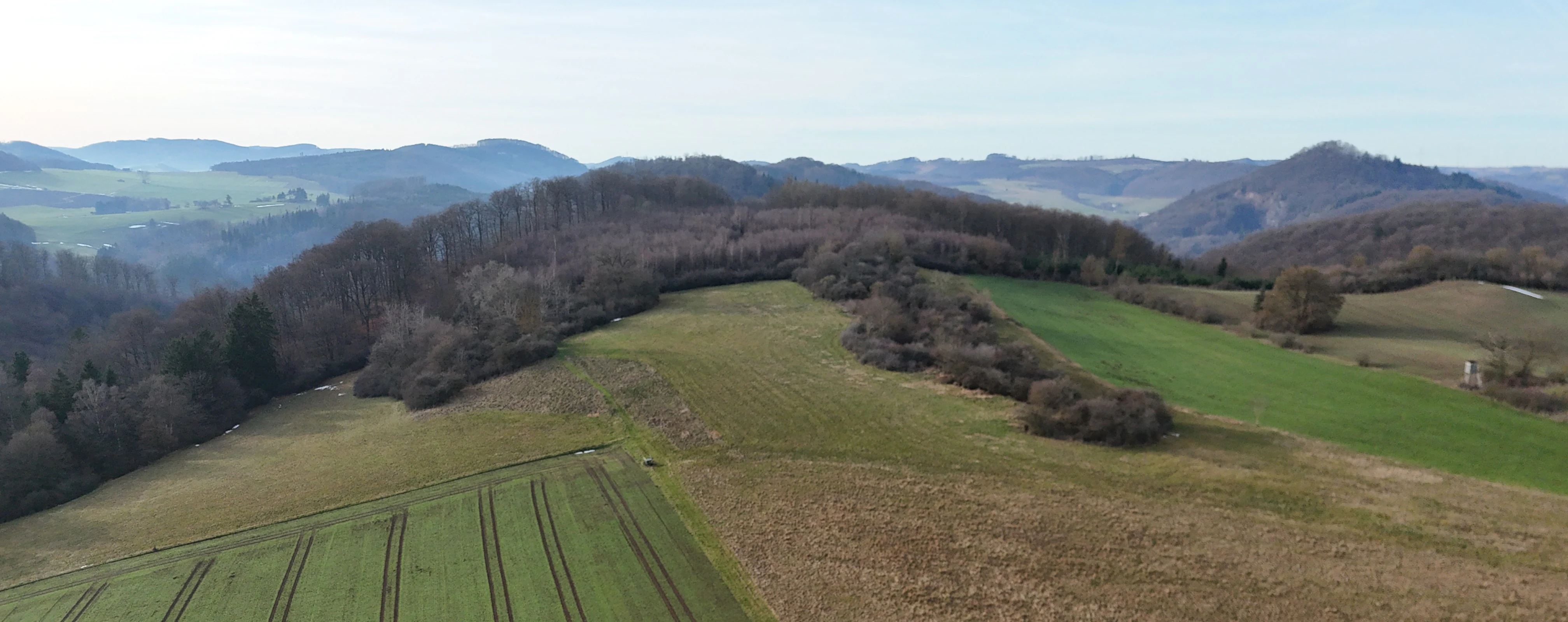
A wide aerial shot of a hilly landscape featuring green agricultural fields in the foreground, transitioning into patches of scrub and deciduous forest, with soft blue hills visible on the horizon.
An aerial view of the Naturschutzgebiet Östlicher Arnstein nature reserve, showing a mosaic of open meadows, cultivated fields, and wooded slopes.

Naturschutzgebiet Östlicher Arnstein history and protected-area timeline

The landscape plan Hoppecketal, prepared by the lower landscape authority of Hochsauerlandkreis in 2001, provided the formal basis for designating Östlicher Arnstein as a Naturschutzgebiet. The plan explicitly recognized the site's biologically valuable mosaic of unfertilized grassland and hedgerows and called for their retention through extensive agricultural use without fertilization. A small Christmas-tree plantation within the area, considered ecologically isolating, was to be progressively converted back to open grassland. In 2023 the reserve was included in the larger Diemel- und Hoppecketal bird protection area, extending its recognition from the regional to the European-scale Natura 2000 framework.

Naturschutzgebiet Östlicher Arnstein landscape and geographic character

The reserve occupies gently sloping, open country on the eastern side of the forested Arnstein hills, in the transition zone between closed woodland and the open field landscape of the Waldecker Gefilde. Topographically, the area is shaped by subtle relief features, including the two small disused quarries that introduce shallow hollows and exposed rock into an otherwise smooth, meadow-dominated terrain. The wider landscape context is defined by the forested slopes to the west and south, the open farmland to the east, and the broader Hoppecke and Diemel valley systems that frame the regional scenery.

Naturschutzgebiet Östlicher Arnstein ecosystems, habitats, and plant life

Ecologically, Östlicher Arnstein is dominated by a base-rich grassland complex. The meadows range from moderately species-rich hay meadows to particularly herb-rich calcareous-influenced stands that are maintained through low-intensity sheep grazing and mowing. Hedgerow and scrub complexes break up the sward, creating structural diversity, edge habitats, and refuges in an agricultural landscape dominated by intensive use. The two disused quarries add further micro-habitat variation with shallow soils, bare substrate, and sheltered niches for specialized plant and invertebrate communities. Documented flora recorded by the Landesamt für Natur, Umwelt und Verbraucherschutz Nordrhein-Westfalen includes field scabious, broad-leaved thyme, lady's bedstraw, small burnet, salad burnet, small hawkweed, creeping buttercup, the meadow oxeye daisy typical of nutrient-poor grassland, ribwort plantain, and round-leaved harebell; the presence of these species together indicates well-developed, semi-natural grassland vegetation rather than sown agricultural pasture. The combination of unfertilized grassland, hedgerows, and structural relief creates a richly layered habitat mosaic for insects, small mammals, and breeding birds within an otherwise simplified agricultural setting.

Naturschutzgebiet Östlicher Arnstein wildlife and species highlights

Although the article does not enumerate specific fauna, the habitat composition supports clear wildlife themes. The mosaic of unfertilized meadows, hedgerows, and scrub provides breeding, foraging, and sheltering habitat for typical grassland and farmland-edge bird species, small mammals, and pollinating insects associated with species-rich calcareous meadow flora. The site's inclusion since 2023 in the Diemel- und Hoppecketal bird protection area reflects its recognized value for breeding and migratory birds in the wider Diemel and Hoppecke valley system, and the two small quarries add further micro-niches for warm-loving invertebrates and reptiles.

Naturschutzgebiet Östlicher Arnstein conservation status and protection priorities

Conservation value lies in the protection of a fragile, base-rich, herb-rich grassland mosaic that is rare within the intensively managed agricultural landscape of the Waldecker Gefilde. The reserve's formal purpose is to maintain unfertilized meadows and intact hedgerow networks through low-intensity grazing and mowing, preserving both the vegetation and the species communities dependent on it. Protection is justified by the rarity, special character, and beauty of the area, as recorded in the designation documents. The site's incorporation into the Diemel- und Hoppecketal EU bird protection area in 2023 raises its profile to the Natura 2000 level, recognizing its role in a much larger landscape-scale conservation network that includes the Hoppecke and Diemel valleys and adjoining forests.

Top sights and standout views in Naturschutzgebiet Östlicher Arnstein

A compact 8.5-hectare reserve dedicated to species-rich, base-rich grassland and hedgerow habitat at the edge of the Sauerland forests. Notable highlights include the small historic quarries that contribute topographic diversity, the ecological role of the site as a refugium for meadow flora in an intensively used agricultural region, the formal landscape-plan-based protection established in 2001, and the 2023 inclusion in the Diemel- und Hoppecketal bird protection area, which underlines the reserve's wider landscape-scale importance.

Monthly climate preview

Long-term representative point measurements detailing monthly temperature and precipitation patterns

Naturschutzgebiet Östlicher Arnstein Climate Normals and Annual Temperature Rhythm

Representative coordinates record measured monthly temperature and precipitation variations across the protected area from 1991 to 2020. Examining the complete twelve-month climatology profile reveals deeper multi-year environmental rhythms and baseline conditions.
Annual mean9 °C
0 °C18 °C
Jan
Feb
Mar
Apr
May12°
Jun15°
Jul18°
Aug18°
Sep14°
Oct
Nov
Dec
Warmest month
July

18 °C

Coolest month
January

-0.2 °C

Wettest month
July

2.6 mm/day

Driest month
April

1.7 mm/day

Park location guide

Geography guide, regional context, and park location map for Naturschutzgebiet Östlicher Arnstein

Naturschutzgebiet Östlicher Arnstein park geography, regions, and map view in Germany

Understand where Naturschutzgebiet Östlicher Arnstein sits in Germany through a broader geographic reading of the surrounding landscape, nearby location context, and its mapped position within the national park landscape.

How Naturschutzgebiet Östlicher Arnstein fits into Germany

Germany is a federal republic in Western and Central Europe with a population of over 83 million across sixteen constituent states. It is Europe's largest economy by nominal GDP and a major global exporter and importer. The capital is Berlin, and the country borders Denmark, Poland, Czech Republic, Austria, Switzerland, France, Luxembourg, Belgium, and the Netherlands.

Wider geography shaping Naturschutzgebiet Östlicher Arnstein in Germany

Germany is located in Western and Central Europe, spanning 357,022 km². It borders Denmark to the north, Poland and the Czech Republic to the east, Austria and Switzerland to the south, and France, Luxembourg, Belgium, and the Netherlands to the west. The country has coastlines on the Baltic Sea and North Sea to the north, with the Alps located in the southern region.

Map view of Naturschutzgebiet Östlicher Arnstein

Use this park location map to pinpoint Naturschutzgebiet Östlicher Arnstein in Germany, understand its exact geographic position, and read its mapped placement within the surrounding landscape more clearly.

Pigeon | © OpenStreetMap contributors

Location context for Naturschutzgebiet Östlicher Arnstein

Hochsauerlandkreis

Visual reference collection showcasing grassland habitats, old quarries, and protected terrain.

Naturschutzgebiet Östlicher Arnstein Photos and Mapped Landscape Scenery

Visual documentation captures the mosaic of base-rich meadows, hedgerow networks, and disused quarries defining the terrain. Photographic records reveal the ecological character of low-intensity grassland nestled between forested hills and open agricultural fields.

A wide aerial shot of a hilly landscape featuring green agricultural fields in the foreground, transitioning into patches of scrub and deciduous forest, with soft blue hills visible on the horizon.

A wide landscape view showing a tilled brown field in the foreground, leading up to a green grassy slope with scattered shrubbery and a forest line in the background under a cloudy sky.

Park atlas

Compare adjacent grassland reserves and protected landscapes across the surrounding region

Parks Near Naturschutzgebiet Östlicher Arnstein and Regional Protected Areas

Browse nearby protected areas and related valley reserves sharing similar meadow ecosystems and topographic terrain. Comparing adjacent conservation landscapes provides deeper geographic context for regional biodiversity.
Nature reserveHessen
About 1.8 km away#1 closest

South

Naturschutzgebiet Am Mühlenberg bei Adorf: Protected Forest and Volcanic Terrain

Geographic overview of a key Hessen nature reserve

Spanning 33 hectares in northern Hessen, Naturschutzgebiet Am Mühlenberg bei Adorf is defined by its Devonian volcanic bedrock and varied microclimates. The reserve provides a detailed look at how aspect and slope create contrasting forest communities, from dry oak stands to cool-air ravine woodland, offering a concentrated study in protected-area botanical richness.

Area
0.335 km²
Established
1992
IUCN
IV
Relief
Upland
A watercolor landscape illustration showing soft, rolling green hills, coniferous trees, and a hazy background.
Nature reserveHochsauerlandkreis
About 1.9 km away#2 closest

West

Naturschutzgebiet Padberg: A Protected Landscape in the Hochsauerlandkreis Region

Diabas geology and forest habitat mapping

Naturschutzgebiet Padberg protects a compact but ecologically rich landscape of beech forests and craggy rock cliffs. Its position above the Diemel valley highlights the relationship between volcanic Diabas topography and woodland development within the Hochsauerlandkreis district.

Area
0.467 km²
Established
2001
Relief
Upland
Climate
Temperate
A soft watercolor illustration of a landscape featuring layered green hills, a distant forest silhouette, and pale sky, rendered in a light, minimalist style.
Nature reserveHochsauerlandkreis
About 3 km away#3 closest

West

Naturschutzgebiet Oberes Diemeltal: Protected Floodplain and River Geography in Hochsauerlandkreis

Mapped riparian landscapes and riverine conservation corridors

Naturschutzgebiet Oberes Diemeltal preserves an undeveloped section of the upper Diemel river valley. The landscape is defined by its branching river network, wet meadows, and rare floodplain vegetation, offering a clear window into the riverine geography of the eastern Sauerland region in Germany.

Area
1.87 km²
Established
2001
Scope
Terrestrial
Water
Major water bodies
Watercolor painting of a wide, soft-toned landscape showing gentle rolling hills, open fields, and a small meandering stream, executed in a minimalist, light-filled style.
Protected landscapeHochsauerlandkreis
About 3.3 km away#4 closest

Northeast

Landschaftsschutzgebiet Freiflächen um Giershagen: Protected Landscape and Regional Map

Agricultural cultural heritage and biodiversity in Hochsauerlandkreis

This protected area in North Rhine-Westphalia preserves 785 hectares of traditional Sauerland countryside. It features extensively managed farmland, rare arable plant habitats, and historically significant landscape structures that support regional biodiversity and long-term ecological stewardship.

Area
7.849 km²
Established
2008
Relief
Upland
Scope
Terrestrial
A horizontal watercolor illustration of a soft, hazy valley with rolling green hills, distant treelines, and wildflowers in the foreground.
Nature reserveNorth Rhine-Westphalia
About 6.9 km away#5 closest

Northwest

Naturschutzgebiet Aabachtal Nature Reserve and Sauerland Protected Stream Valley Geography

A preserved fluvial landscape in North Rhine-Westphalia

Naturschutzgebiet Aabachtal is a protected nature reserve in the northern Sauerland of North Rhine-Westphalia. Centered on the Aabach stream, it protects a classic Mittelgebirge valley landscape defined by meandering watercourses, lush floodplain meadows, and deciduous forest slopes, serving as a critical habitat for specialized moisture-loving flora and diverse riparian fauna.

Area
0.716 km²
Established
2001
Relief
Upland
Scope
Terrestrial
A soft watercolor painting of a serene natural landscape with rolling hills, a central body of water, and green trees against a pale, warm-toned sky.
Nature reserveWaldeck-Frankenberg
About 8.3 km away#6 closest

West

Naturschutzgebiet Diemelsee Nature Reserve: Geographic Atlas and Protected Landscape

Waldeck-Frankenberg Wetland and Reservoir Margin Analysis

Located in northern Hesse, Naturschutzgebiet Diemelsee serves as a crucial protected sanctuary where the Itter stream enters the reservoir. This reserve features a distinctive mosaic of mudflats, reed beds, and swamp-like woodland, shaped by annual water level changes that create a unique habitat for local birdlife and pioneer flora within the broader Sauerland foothills.

Area
0.187 km²
Established
1965
Relief
Lowland
Scope
Terrestrial
A soft watercolor illustration of rolling green hills, a cluster of trees, and distant low mountains in muted pastel tones.
Protected landscapeHochsauerlandkreis
About 8.5 km away#7 closest

Northeast

Landschaftsschutzgebiet Freiflächen um Erlinghausen / Auf der Sandkuhle: Protected Area Map

A regional landscape conservation zone in Hochsauerlandkreis

This protected landscape encompasses 548 hectares of rural terrain surrounding Erlinghausen. It is defined by its traditional agricultural matrix, orchard meadows, and cultural heritage features that maintain the historic character of the eastern Sauerland foothills.

Area
5.487 km²
Established
2008
Relief
Upland
Scope
Terrestrial
A horizontal watercolor painting of a calm lake surrounded by a pine forest and rolling hills under a soft light.
Protected landscapeKreis Paderborn
About 8.8 km away#8 closest

North

Landschaftsschutzgebiet FFH-Gebiet Fürstenberger Wald: Protected Area and Forest Geography

A woodland conservation landscape in the Kreis Paderborn foothills

This protected area features a cohesive block of old-growth beech forest, enriched by significant deadwood habitats and a dense internal network of brooks. Located within the Kreis Paderborn administrative district, the landscape serves as a key ecological connector in the eastern Sauerland, balancing moist valley meadows with upland forest ridges and ongoing deciduous forest restoration efforts.

Area
14.925 km²
Established
2007
Relief
Upland
Climate
Temperate

Common questions about visiting, size, designation, and location context for Naturschutzgebiet Östlicher Arnstein

Naturschutzgebiet Östlicher Arnstein FAQs for park facts, access, geography, and protected area context

Find quick answers about Naturschutzgebiet Östlicher Arnstein, including protected-area facts, park geography, trail and visitor context, and how the park fits into its surrounding country and regional landscape.
MoriAtlas Explorer

Continue Your Protected Areas Search Across the Global Atlas

Deepen your exploration by continuing the structured search for national parks and protected areas worldwide. Utilize the comprehensive filtering capabilities to compare different conservation landscapes and refine your understanding of global park geography. Discover more about the distribution and characteristics of protected natural areas.

Global natural geography