
Mori Atlas logo
Nature reserveNaturschutzgebiet Padberg

Geographic analysis of rocky terrain, forest biotopes, and regional protected land connectivity

Naturschutzgebiet Padberg: Mapping Protected Beech Forests and Diabas Cliff Habitats in Hochsauerlandkreis

Naturschutzgebiet Padberg represents a distinct protected landscape within the Hochsauerlandkreis region of Germany, centered on a prominent Diabas hilltop overlooking the upper Diemel valley. This nature reserve preserves a network of near-natural beech forests on base-rich soils, complemented by sun-exposed cliff habitats and unique geological formations. The area serves as a critical node for regional biodiversity, connecting woodland and rocky biotopes through its integration within the broader FFH site and bird protection networks.

beech forestwoodland reservecliff habitatsdiabas geologyNatura 2000FFH site
A stylized vector illustration of a forested hillside with coniferous and deciduous trees under a cloudy sky.

Naturschutzgebiet Padberg

Nature reserve

Park overview

Structured park overview, official facts, and landscape profile for Naturschutzgebiet Padberg

Naturschutzgebiet Padberg park facts, protected area profile, and essential visitor context

Review the core facts for Naturschutzgebiet Padberg, including designation, size, terrain, visitor scale, habitats, and operating context in one park-focused overview.

About Naturschutzgebiet Padberg

Naturschutzgebiet Padberg is a compact protected forest reserve in the eastern Sauerland region of North Rhine-Westphalia. It sits on the Diabas hilltop of the Padberg and runs down the slope toward the Diemel valley south of the village of Padberg, within the broader city area of Marsberg.

The reserve was established in 2001 by the Hochsauerlandkreis as part of the Hoppecketal landscape plan, giving legal protection to a forest mosaic that had long been recognized for its ecological quality. At the European level it is part of the FFH site "Wälder bei Padberg" ("Forests near Padberg"), under code DE 4518-302, and since 2023 it has been included within the Diemel- and Hoppecketal bird protection area. This layering of national and European designations highlights its regional ecological importance.

The state agency for nature, environment and consumer protection of North Rhine-Westphalia describes the area as holding representative examples of base-rich beech forests in good condition for the natural region. Within the upper Diemel valley, it functions as a regionally significant element of near-natural beech woodland and cliff habitats, connected to a broader network of forest and rock biotopes in the surrounding countryside.

Quick facts and research context for Naturschutzgebiet Padberg

Naturschutzgebiet Padberg covers roughly 46.7 hectares of forest and cliff habitat on a Diabas hilltop south of Padberg village in the Marsberg area of the Hochsauerlandkreis. It was designated as a nature reserve in 2001 through the Hoppecketal landscape plan by the Hochsauerlandkreis, and it lies within the FFH site "Wälder bei Padberg" (DE 4518-302), which covers around 94 hectares. Since 2023 it has also been part of the Diemel- and Hoppecketal bird protection area, and it is largely surrounded by the Hoppecke-Diemel-Bergland landscape protection area.

Protection and recognition

Explore documented terrestrial protection parameters and designation records.

Naturschutzgebiet Padberg Protection Status and International Recognition

Naturschutzgebiet Padberg maintains a registered terrestrial protection scope within the official conservation framework. Structured records outline the documented designation status, management scope, and international recognition parameters associated with the landscape.

Protection details

Protection scope
Terrestrial
Transboundary protection
No
Park context

Deeper park guide and search-rich context for Naturschutzgebiet Padberg

Naturschutzgebiet Padberg history, landscape, wildlife, and travel context

Explore Naturschutzgebiet Padberg through its history, landscape character, ecosystems, wildlife, conservation priorities, cultural context, and seasonal travel timing in a structured park guide built for atlas discovery and search intent.

Why Naturschutzgebiet Padberg stands out

The reserve is best known for its well-developed stands of near-natural beech forest on base-rich soils, including locally dominant pedunculate oak and warmer oak-hornbeam communities on sunny rock cliffs. The old quarry and Diabas outcrops add distinctive rocky and cliff habitats to the woodland setting. Its combination of mature beech forest and exposed Diabas cliffs within a compact area, set above the upper Diemel valley, gives the reserve a regionally important role as a hub of woodland and rock biotopes connecting with surrounding protected forests.
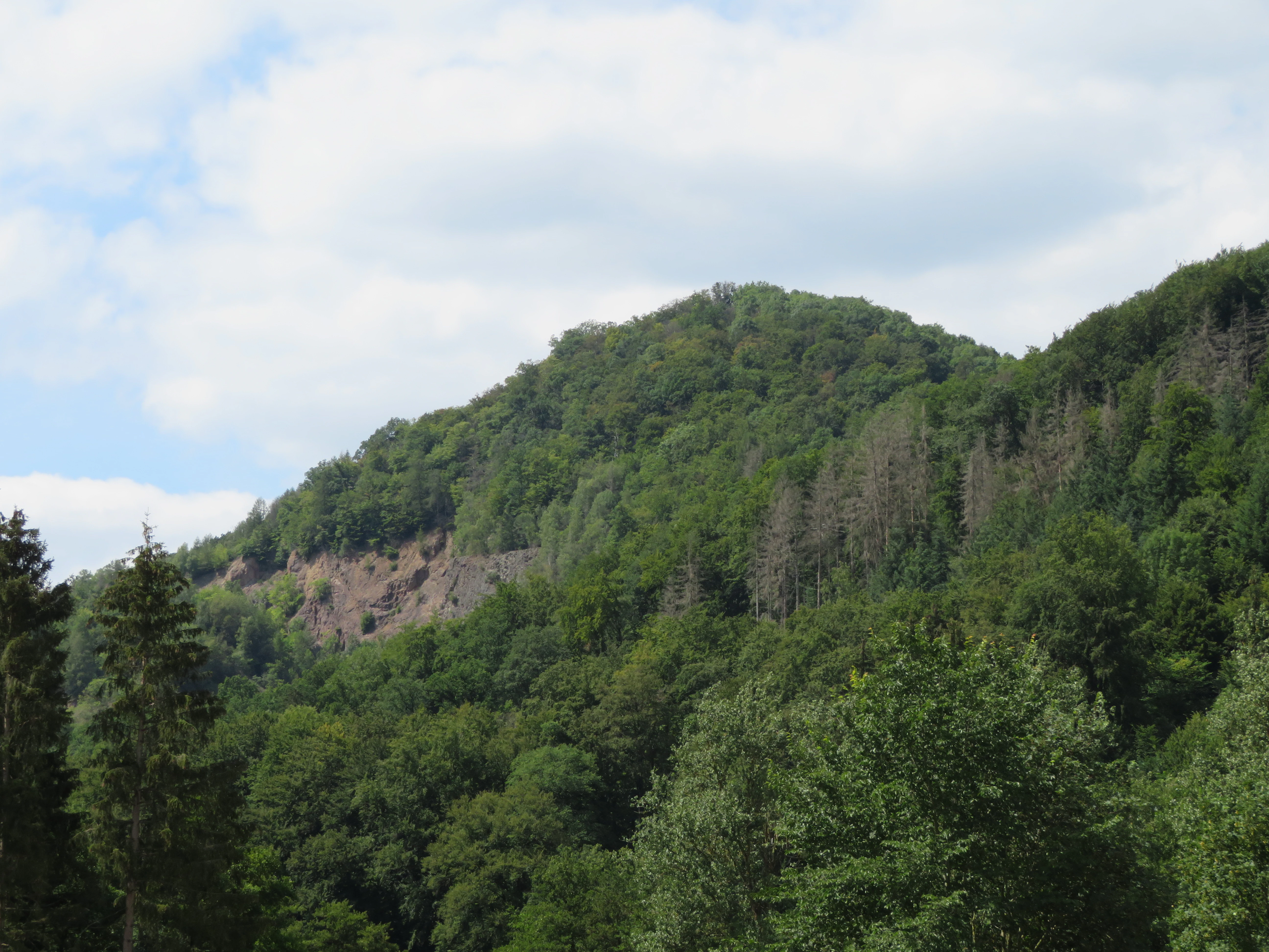
A wide outdoor view of a forested hillside with a rocky, light-colored quarry section exposed on the slope, under a partly cloudy sky.
A view of the landscape at Naturschutzgebiet Padberg, showcasing the forested hills and exposed rock formations of the former quarry.

Naturschutzgebiet Padberg history and protected-area timeline

The modern protection of the area began in 2001, when the Hochsauerlandkreis incorporated the Diabas hilltop and surrounding beech forest into the Hoppecketal landscape plan and formally designated it as a Naturschutzgebiet. The standard German rationale was applied, citing the rarity, particular character, and beauty of the area as reasons for protection.

In 2004 the site was recognized at the European level as part of the Fauna-Flora-Habitat area "Wälder bei Padberg", extending the conservation framework beyond purely national designation. More recently, in 2023, the reserve became part of the larger Diemel- and Hoppecketal bird protection area, reflecting its growing recognition for avian as well as woodland and cliff habitats.

Alongside its formal protection history, the area also carries traces of older human activity. A former quarry, whose southern portion now serves as a soil depot, sits within the reserve and is locally significant for cliff-breeding wildlife, and remains of an old hillfort (Wallburg) can also be found within the protected area.

Naturschutzgebiet Padberg landscape and geographic character

The landscape of Naturschutzgebiet Padberg is shaped by its underlying geology. The hilltop consists of Diabas, a hard volcanic-related rock that gives the site its distinctive ridgeline and produces the craggy outcrops and cliffs found on its slopes.

From this Diabas summit, the land drops down toward the Diemel valley, so the reserve combines a forested hilltop with a steep hillside setting. Sun-exposed rock cliffs along parts of the slope create warm microhabitats that contrast with the cooler, shaded beech forest on the main body of the hill.

A former quarry introduces an additional element of artificial landscape into the otherwise natural setting, with the southern part of the quarry now being used as a soil depot. Smaller, mostly reforested excavations can also be found in the eastern part of the reserve, softening the impact of earlier human disturbance on the broader forest landscape.
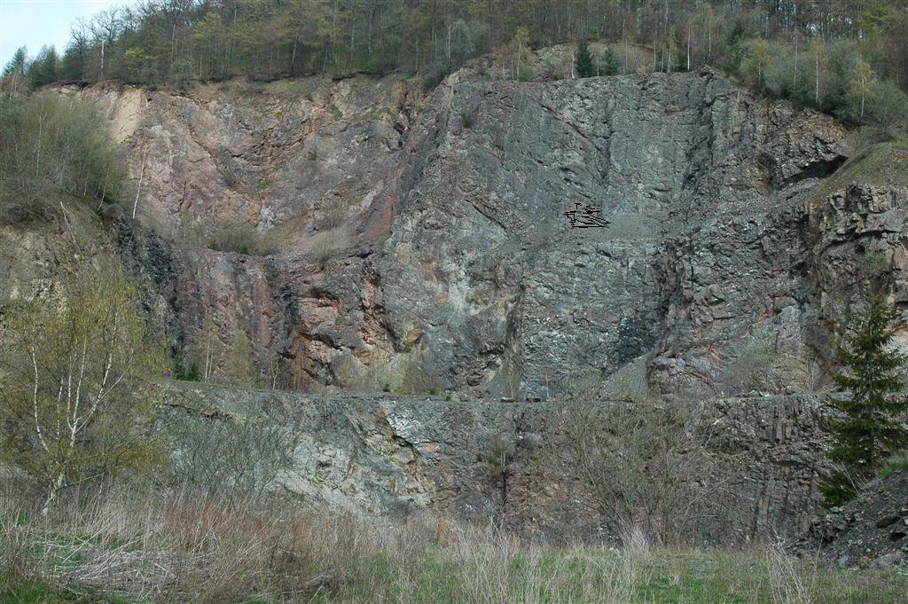
A wide shot of a rock quarry face with vertical cliff sections, surrounded by forest and brush, within a nature reserve.
A view of the former stone quarry within the Naturschutzgebiet Padberg nature reserve.

Naturschutzgebiet Padberg ecosystems, habitats, and plant life

Ecologically, the reserve is dominated by near-natural European beech forest, which forms the core habitat across most of the protected area. These are base-rich beech woodlands in good condition, representing one of the characteristic forest types of the natural region.

In some localities, the canopy shifts to include pedunculate oak, hornbeam, and scattered spruce, with pedunculate oak becoming locally dominant in parts of the western area. On sunny rock cliffs in the southeast, a warmer oak-hornbeam community takes over, reflecting the drier, more exposed conditions found there.

The Diabas cliffs and former quarry add a secondary but ecologically important rocky habitat layer to the woodland, supporting specialist ferns, mosses, and cliff-dwelling plant communities. Together, the forest, cliff, and edge habitats form an interconnected mosaic that supports a rich diversity of understorey plants such as lily of the valley, wild garlic, wood anemones, hepatica, and a wide range of woodland grasses and sedges documented for the area.

Naturschutzgebiet Padberg wildlife and species highlights

Wildlife interest in the reserve centers on the combination of mature beech forest, cliff habitats, and former quarry walls. The cliffs and the old quarry provide nesting sites for cliff-breeding birds, and the eagle owl (Uhu) is recorded as breeding within the former quarry area.

The broader forest supports typical woodland birdlife of the central German uplands, while the inclusion of the reserve within the Diemel- and Hoppecketal bird protection area since 2023 underlines its recognized value for bird conservation at a regional scale. The mix of dense beech canopy, open warm oak-hornbeam stands, and rocky cliff faces creates a varied habitat structure that supports both forest-interior and cliff-associated species.

Naturschutzgebiet Padberg conservation status and protection priorities

The reserve's conservation importance lies in its well-preserved beech forests on base-rich soils, considered representative of the natural region and in good condition according to the North Rhine-Westphalian state's specialist information system. These forests, together with the Diabas cliff habitats and old quarry exposures, form a regionally important core of near-natural woodland and rock biotope habitats.

By being part of the broader FFH site "Wälder bei Padberg", the area is integrated into the European Natura 2000 network, reflecting its habitat value beyond purely local or national significance. Its inclusion in the Diemel- and Hoppecketal bird protection area further extends this network to bird conservation, connecting the woodland and cliff habitats of the Padberg with other protected forest and valley landscapes in the region.

The reserve also buffers and complements the surrounding landscape protection areas, with most of it framed by the Hoppecke-Diemel-Bergland landscape protection area and, to the north, parts of the Oberes Orpetal landscape protection area. This surrounding buffer of protected countryside strengthens the long-term resilience of the woodland and cliff habitats within the reserve itself.

Naturschutzgebiet Padberg cultural meaning and human context

The cultural context of the area is shaped by long-standing human use of the landscape, especially through quarrying. The former quarry within the reserve reflects a mining or stone-extraction history tied to the Diabas geology of the hill, and its southern portion now functions as a soil depot, showing how the site has been progressively absorbed back into a managed, protected setting.

Remains of an old hillfort (Wallburg) within the protected area hint at older, possibly medieval, defensive use of the prominent hilltop above the Diemel valley, suggesting that this elevated Diabas site has long served as both a natural landmark and a place of human significance in the region.

Top sights and standout views in Naturschutzgebiet Padberg

Among the defining features of Naturschutzgebiet Padberg is the Diabas hilltop and its near-natural beech forest on base-rich soils, which the regional authorities highlight as representative of the natural region in good condition. Warm oak-hornbeam woodland on sunny Diabas cliffs in the southeast adds a distinctive secondary habitat type.

The old quarry with its cliff-breeding eagle owl, the surrounding FFH area "Wälder bei Padberg", and the inclusion within the Diemel- and Hoppecketal bird protection area since 2023 are also notable features, marking the reserve as a small but ecologically well-connected node in the broader protected landscape network of the upper Diemel and Hoppecke valleys.

Best time to visit Naturschutzgebiet Padberg

The reserve can be visited year-round within the limits of the German nature protection framework, with each season offering a different character. Spring is the most floristically striking period, when woodland wildflowers such as wild garlic, hepatica, lily of the valley, and wood anemones come into bloom across the beech forest floor.

Summer brings full leaf canopy and dense shade through the beech stands, with the warmer oak-hornbeam communities on the sunny cliffs offering a contrast of lighter, drier woodland. Autumn transforms the forest with beech mast and seasonal leaf color, while winter opens up views through the deciduous canopy across the Diabas hilltop and toward the upper Diemel valley.

Monthly climate preview

Long-term temperature ranges and monthly precipitation averages for Hochsauerlandkreis

Naturschutzgebiet Padberg Climate Normals and Annual Weather Patterns

Representative coordinate measurements trace the multi-year temperature fluctuations and monthly precipitation rhythms across Naturschutzgebiet Padberg from 1991 to 2020. Examining the complete twelve-month climate profile reveals deeper statistical normals and detailed seasonal variations for this protected area.
Annual mean9 °C
0 °C18 °C
Jan
Feb
Mar
Apr
May12°
Jun15°
Jul18°
Aug18°
Sep14°
Oct
Nov
Dec
Warmest month
July

18 °C

Coolest month
January

-0.2 °C

Wettest month
July

2.6 mm/day

Driest month
April

1.7 mm/day

Park location guide

Geography guide, regional context, and park location map for Naturschutzgebiet Padberg

Naturschutzgebiet Padberg park geography, regions, and map view in Germany

Understand where Naturschutzgebiet Padberg sits in Germany through a broader geographic reading of the surrounding landscape, nearby location context, and its mapped position within the national park landscape.

How Naturschutzgebiet Padberg fits into Germany

Germany is a federal republic in Western and Central Europe with a population of over 83 million across sixteen constituent states. It is Europe's largest economy by nominal GDP and a major global exporter and importer. The capital is Berlin, and the country borders Denmark, Poland, Czech Republic, Austria, Switzerland, France, Luxembourg, Belgium, and the Netherlands.

Wider geography shaping Naturschutzgebiet Padberg in Germany

Germany is located in Western and Central Europe, spanning 357,022 km². It borders Denmark to the north, Poland and the Czech Republic to the east, Austria and Switzerland to the south, and France, Luxembourg, Belgium, and the Netherlands to the west. The country has coastlines on the Baltic Sea and North Sea to the north, with the Alps located in the southern region.

Map view of Naturschutzgebiet Padberg

Use this park location map to pinpoint Naturschutzgebiet Padberg in Germany, understand its exact geographic position, and read its mapped placement within the surrounding landscape more clearly.

Pigeon | © OpenStreetMap contributors

Location context for Naturschutzgebiet Padberg

Hochsauerlandkreis

Visualizing the Diabas geological formations, beech forests, and cliff habitats of the reserve

Naturschutzgebiet Padberg Photos and Landscape Scenery

Photographs capture the rugged Diabas ridges and mature beech woodland slopes descending toward the upper Diemel valley. Visual documentation reveals the distinct terrain and cliff habitats that define the protected area character.
A wide outdoor view of a forested hillside with a rocky, light-colored quarry section exposed on the slope, under a partly cloudy sky.

A wide patch of white-flowered wild garlic plants covering the forest floor in spring.

A wide shot of a rock quarry face with vertical cliff sections, surrounded by forest and brush, within a nature reserve.

Park atlas

Discover connected woodland reserves and surrounding valley landscapes

Parks Near Naturschutzgebiet Padberg, Exploring Regional Protected Areas

Visitors exploring Naturschutzgebiet Padberg can continue browsing adjacent woodland reserves and rocky valley habitats across the surrounding district. Comparing nearby protected areas reveals broader patterns of regional forest geography and interconnected natural terrain.
A soft watercolor illustration of a landscape featuring layered green hills, a distant forest silhouette, and pale sky, rendered in a light, minimalist style.
Nature reserveHochsauerlandkreis
About 1.7 km away#1 closest

Southwest

Naturschutzgebiet Oberes Diemeltal: Protected Floodplain and River Geography in Hochsauerlandkreis

Mapped riparian landscapes and riverine conservation corridors

Naturschutzgebiet Oberes Diemeltal preserves an undeveloped section of the upper Diemel river valley. The landscape is defined by its branching river network, wet meadows, and rare floodplain vegetation, offering a clear window into the riverine geography of the eastern Sauerland region in Germany.

Area
1.87 km²
Established
2001
Scope
Terrestrial
Water
Major water bodies
A soft watercolor illustration showing a gentle, rolling landscape with green meadows, trees, and distant hills under a pale sky.
Nature reserveHochsauerlandkreis
About 1.9 km away#2 closest

East

Naturschutzgebiet Östlicher Arnstein: Protected Nature Reserve and Geographic Map

Grassland mosaic and historic terrain in Hochsauerlandkreis

Naturschutzgebiet Östlicher Arnstein comprises 8.5 hectares of species-rich meadows and hedgerow complexes nestled in the Waldecker Gefilde. This reserve offers a significant look at regional grassland conservation, providing habitat diversity through its base-rich soils and disused quarry sites. It acts as a vital transition point between the forested Sauerland slopes and the surrounding open agricultural landscape.

Area
0.085 km²
Established
2001
Relief
Lowland
Climate
Temperate
Nature reserveHessen
About 2.6 km away#3 closest

Southeast

Naturschutzgebiet Am Mühlenberg bei Adorf: Protected Forest and Volcanic Terrain

Geographic overview of a key Hessen nature reserve

Spanning 33 hectares in northern Hessen, Naturschutzgebiet Am Mühlenberg bei Adorf is defined by its Devonian volcanic bedrock and varied microclimates. The reserve provides a detailed look at how aspect and slope create contrasting forest communities, from dry oak stands to cool-air ravine woodland, offering a concentrated study in protected-area botanical richness.

Area
0.335 km²
Established
1992
IUCN
IV
Relief
Upland
Watercolor painting of a wide, soft-toned landscape showing gentle rolling hills, open fields, and a small meandering stream, executed in a minimalist, light-filled style.
Protected landscapeHochsauerlandkreis
About 4.5 km away#4 closest

East

Landschaftsschutzgebiet Freiflächen um Giershagen: Protected Landscape and Regional Map

Agricultural cultural heritage and biodiversity in Hochsauerlandkreis

This protected area in North Rhine-Westphalia preserves 785 hectares of traditional Sauerland countryside. It features extensively managed farmland, rare arable plant habitats, and historically significant landscape structures that support regional biodiversity and long-term ecological stewardship.

Area
7.849 km²
Established
2008
Relief
Upland
Scope
Terrestrial
A horizontal watercolor illustration of a soft, hazy valley with rolling green hills, distant treelines, and wildflowers in the foreground.
Nature reserveNorth Rhine-Westphalia
About 5.5 km away#5 closest

North

Naturschutzgebiet Aabachtal Nature Reserve and Sauerland Protected Stream Valley Geography

A preserved fluvial landscape in North Rhine-Westphalia

Naturschutzgebiet Aabachtal is a protected nature reserve in the northern Sauerland of North Rhine-Westphalia. Centered on the Aabach stream, it protects a classic Mittelgebirge valley landscape defined by meandering watercourses, lush floodplain meadows, and deciduous forest slopes, serving as a critical habitat for specialized moisture-loving flora and diverse riparian fauna.

Area
0.716 km²
Established
2001
Relief
Upland
Scope
Terrestrial
A soft watercolor painting of a serene natural landscape with rolling hills, a central body of water, and green trees against a pale, warm-toned sky.
Nature reserveWaldeck-Frankenberg
About 7 km away#6 closest

Southwest

Naturschutzgebiet Diemelsee Nature Reserve: Geographic Atlas and Protected Landscape

Waldeck-Frankenberg Wetland and Reservoir Margin Analysis

Located in northern Hesse, Naturschutzgebiet Diemelsee serves as a crucial protected sanctuary where the Itter stream enters the reservoir. This reserve features a distinctive mosaic of mudflats, reed beds, and swamp-like woodland, shaped by annual water level changes that create a unique habitat for local birdlife and pioneer flora within the broader Sauerland foothills.

Area
0.187 km²
Established
1965
Relief
Lowland
Scope
Terrestrial
A wide watercolor-style illustration of a soft landscape featuring rolling green hills, scattered forest patches, and pale pink mountains in the background with a light sky.
Nature reserveNorth Rhine-Westphalia
About 7.2 km away#7 closest

West

Hollenloch Nature Reserve: Karst Cave Systems and Protected Limestone Woodland Geography

Exploration of subterranean geology and regional karst habitats

Hollenloch stands as one of the longest and deepest cave systems within the Sauerland, developed inside dense Upper Devonian reef limestone. This protected site integrates surface karst features like the Schwalgloch with specialized forest ecosystems, providing a vital subterranean refuge for diverse bat species and a rich record of prehistoric human activity.

Area
0.032 km²
Established
2001
Relief
Upland
Climate
Temperate
A horizontal watercolor painting of a calm lake surrounded by a pine forest and rolling hills under a soft light.
Protected landscapeKreis Paderborn
About 8 km away#8 closest

North

Landschaftsschutzgebiet FFH-Gebiet Fürstenberger Wald: Protected Area and Forest Geography

A woodland conservation landscape in the Kreis Paderborn foothills

This protected area features a cohesive block of old-growth beech forest, enriched by significant deadwood habitats and a dense internal network of brooks. Located within the Kreis Paderborn administrative district, the landscape serves as a key ecological connector in the eastern Sauerland, balancing moist valley meadows with upland forest ridges and ongoing deciduous forest restoration efforts.

Area
14.925 km²
Established
2007
Relief
Upland
Climate
Temperate

Common questions about visiting, size, designation, and location context for Naturschutzgebiet Padberg

Naturschutzgebiet Padberg FAQs for park facts, access, geography, and protected area context

Find quick answers about Naturschutzgebiet Padberg, including protected-area facts, park geography, trail and visitor context, and how the park fits into its surrounding country and regional landscape.
MoriAtlas Explorer

Continue Your Protected Areas Search Across the Global Atlas

Deepen your exploration by continuing the structured search for national parks and protected areas worldwide. Utilize the comprehensive filtering capabilities to compare different conservation landscapes and refine your understanding of global park geography. Discover more about the distribution and characteristics of protected natural areas.

Global natural geography