Mori Atlas logo
Nature reserveRezerwat przyrody Moczydło

Examining the intersection of ancient mining excavations and limestone ridge ecosystems

Rezerwat przyrody Moczydło Nature Reserve: A Mapped Geological and Historical Landmark

Rezerwat przyrody Moczydło represents a highly specific protected area in the Świętokrzyskie Voivodeship, established to maintain the integrity of its mineral-rich limestone hill and industrial history. The reserve maps a compact network of historical lead and barite mining fissures alongside sensitive xerothermic calcareous grassland communities. This site offers significant insight into the geological core of the Holy Cross Mountains and the enduring traces of early extraction within a strictly managed natural environment.

nature reserveŚwiętokrzyskieHoly Cross MountainsChęcińsko-Kielecki Landscape Parkpartial reservenon-living natural features

Rezerwat przyrody Moczydło

Nature reserve

Park overview

Structured park overview, official facts, and landscape profile for Moczydło Nature Reserve

Moczydło Nature Reserve park facts, protected area profile, and essential visitor context

Review the core facts for Moczydło Nature Reserve, including designation, size, terrain, visitor scale, habitats, and operating context in one park-focused overview.

About Moczydło Nature Reserve

Moczydło Nature Reserve protects a small but unusually rich slice of the Holy Cross Mountains, combining geological, mining-historical, and ecological values on a single hill near the village of Jaworznia. The reserve is classified as a partial reserve focused on inanimate natural features, reflecting the central importance of its rocky terrain and historical excavations.

The protected site encompasses 16.35 hectares on the hill known as Moczydło, also called Góra Jaworzyńska, which reaches 317 meters above sea level. Its underlying rocks are carbonate formations belonging to the classic limestone and dolomite geology of the Holy Cross range. Through these carbonate rocks run calcite veins that historically hosted deposits of galena, a lead-bearing mineral, and baryte, giving the site a documented ore-mining tradition stretching back into the early modern period.

Mining activity here was carried out in an interrupted but persistent way from the seventeenth century into the early nineteenth century. Rather than leaving behind only vague surface hints, this history is preserved in tangible form as small shafts, prospect openings, and fissures in the rock, generally referred to as 'szpary' and 'szybiki' in Polish. Their good state of preservation is one of the reserve's defining qualities and is part of the reason the site was given legal protection. It also leaves open the possibility of adapting some of these features for limited visitor use in the future, where appropriate conservation allows.

Overlying the mineralized rocks, the slopes support a fragment of calcareous xerothermic grassland, a habitat type associated with dry, sun-exposed limestone terrain. Within the broader Świętokrzyskie region, such warm-loving and drought-adapted plant communities are rare, and the reserve's preserved murawy kserotermiczne contribute meaningfully to the region's ecological diversity. The combination of mineralogical remains and dry-grassland vegetation on the same hill makes Moczydło an unusually compact site for studying two very different aspects of the Polish natural and cultural landscape at once.

The reserve lies within the broader Chęcińsko-Kielecki Landscape Park, which provides additional landscape-scale protection around the reserve. Its registration number under the regional conservation authority is 055, and it is administered as a partial reserve, meaning that only specific features are under strict protection while the wider area continues to function within the surrounding landscape park framework.

Quick facts and research context for Moczydło Nature Reserve

Moczydło Nature Reserve is located in the Holy Cross Mountains (Góry Świętokrzyskie), in the Kieleckie mesoregion of central Poland. It forms part of the larger Chęcińsko-Kielecki Landscape Park and is administered as a partial reserve focused on non-living natural features. The site covers approximately 16.35 hectares and was legally established in 1995.

The reserve sits on a hill known as Moczydło or Góra Jaworzyńska and protects evidence of historical ore mining, including small shafts and fissures cut into carbonate rocks laced with calcite veins containing galena and barite. Overlying and surrounding these geological traces are fragments of calcareous xerothermic grassland, one of the few such dry grassland communities preserved in this part of the Świętokrzyskie region.

Protection and recognition

Terrestrial protected area conservation records and management parameters

Rezerwat przyrody Moczydło Protection Status and Designation Record

Rezerwat przyrody Moczydło maintains documented terrestrial protection status within its regional conservation framework. Official records compile available designation details and administrative recognition metrics for structural park analysis.

Protection details

Protection scope
Terrestrial
Park context

Deeper park guide and search-rich context for Moczydło Nature Reserve

Moczydło Nature Reserve history, landscape, wildlife, and travel context

Explore Moczydło Nature Reserve through its history, landscape character, ecosystems, wildlife, conservation priorities, cultural context, and seasonal travel timing in a structured park guide built for atlas discovery and search intent.

Why Moczydło Nature Reserve stands out

Moczydło is best known for its exceptionally well-preserved surface traces of early metal ore mining, including narrow shafts and fissures that make the site's mining history unusually readable in the landscape. These archaeological-industrial remains are set within carbonate rock formations cut by calcite veins that historically carried galena and baryte. Equally distinctive is the reserve's surviving xerothermic calcareous grassland, a warm-loving, drought-adapted plant community that grows directly on the limestone slopes and forms a rare ecological complement to the mineral heritage of the site.

Moczydło Nature Reserve history and protected-area timeline

Moczydło Nature Reserve was officially established in 1995 by order of the Minister of Environmental Protection, Natural Resources, and Forestry, with the founding act published in the official Polish legal monitor. The original founding documents gave the reserve an area of 16.21 hectares, slightly smaller than the 16.35 hectares recorded in later references, but the essential identity and purpose of the site have remained unchanged since creation.

The protection it provides is closely tied to mining history that long predates the reserve. The carbonate rocks of Góra Jaworzyńska contain calcite veins carrying galena and baryte, and from the seventeenth century through the early nineteenth century, the hill was worked intermittently for these ores. Small shafts, prospect pits, and fissures left by this activity survived in the landscape in unusually legible condition, and their preservation is one of the explicit reasons the site was designated.

Because the reserve's main subject of protection is a historical industrial-archaeological landscape set within a geologically distinctive hill, its history is effectively a layered story: hundreds of years of small-scale ore extraction on one hand, and a late-twentieth-century conservation designation designed to permanently stabilize and protect that evidence on the other.

Moczydło Nature Reserve landscape and geographic character

The landscape of Moczydło Nature Reserve is shaped by a single modest hill in the Holy Cross Mountains, locally known as both Moczydło and Góra Jaworzyńska, which rises to 317 meters above sea level. The terrain is rocky and mineralized, defined by Paleozoic-era carbonate rocks typical of the older geological core of the Świętokrzyskie region.

Across and through these carbonate rocks run calcite veins, which historically concentrated the lead-bearing galena and baryte that attracted miners to the site. The surface today carries clear traces of this underground prospecting in the form of narrow shafts and fissures cut into the hillside. Where the rock is exposed, it reveals the geological structure that made the hill economically interesting in earlier centuries.

At ground level above the bedrock, dry, sun-exposed limestone slopes support a different kind of landscape: open xerothermic grassland communities, with thin soils and drought-tolerant vegetation suited to the warm microclimate of the hill. This combination of rocky geological exposures, small mining excavations, and dry calcareous grassland gives the reserve a compact, multi-layered physical character unusual even within the varied terrain of the Chęcińsko-Kielecki Landscape Park.

Moczydło Nature Reserve ecosystems, habitats, and plant life

Ecologically, Moczydło Nature Reserve is significant primarily for the fragments of xerothermic calcareous grassland that survive on its sun-exposed limestone slopes. These plant communities, known in Polish as murawy kserotermiczne, are adapted to dry, warm conditions and to the thin calcareous soils that develop directly over limestone bedrock. Within the Holy Cross Mountains as a whole, such habitats are restricted and locally rare, which gives even small surviving patches considerable conservation value.

The grassland vegetation here coexists with exposed rock outcrops, mining shafts, and prospect fissures, creating a varied microhabitat mosaic in a very small area. Open rock surfaces and disturbed ground around old workings likely contribute to habitat heterogeneity, supporting plant communities that depend on sun, warmth, and well-drained substrate rather than dense tree cover.

Because the reserve is classified as a partial reserve focused on non-living natural features, active woodland cover is not the primary management concern. Instead, maintaining the open character of the slopes is essential for the long-term survival of the calcareous grassland species that depend on continued light availability and minimal soil development.

Moczydło Nature Reserve wildlife and species highlights

The reserve does not emphasize large mammal populations or iconic vertebrate species. Its wildlife value is tied mainly to the invertebrate and plant communities characteristic of dry calcareous grassland, which typically support specialized insects, spiders, and other groups adapted to warm, open, floristically rich habitats. Because the reserve is small and partially protected, it functions more as a refuge for these specialized dry-grassland taxa than as a habitat for larger woodland wildlife.

Rather than cataloging specific species, the reserve's broader wildlife significance lies in its role as one of the small stepping-stone sites of xerothermic vegetation within the broader Chęcińsko-Kielecki Landscape Park, contributing to the regional network of dry-grassland refugia in the Holy Cross Mountains.

Moczydło Nature Reserve conservation status and protection priorities

Conservation at Moczydło centers on preserving both the geological-mining heritage and the ecological character of the site's calcareous slopes in a coordinated way. The reserve is legally protected as a partial reserve, meaning that strict protection applies to defined features, while the broader landscape continues to function under the surrounding Chęcińsko-Kielecki Landscape Park.

The first conservation priority is the preservation of historical ore-mining shafts and fissures as legible features of the cultural-industrial landscape. These traces of seventeenth- to nineteenth-century mining activity are fragile and irreversible if damaged, which is why the reserve's founding act specifically lists them among the protected subjects. The reserve's good state of preservation since 1995 reflects the success of this protection.

The second priority is ecological: maintaining the open, dry calcareous grassland communities on the slopes. Where succession begins to encroach on these patches, active management such as controlled removal of woody growth can be necessary, though such interventions are not detailed in the source material. By keeping both the mining archaeology and the rare grassland stable, the reserve contributes to two complementary conservation goals at once in the Holy Cross Mountains.

Moczydło Nature Reserve cultural meaning and human context

Beyond its natural values, Moczydło carries an embedded cultural and industrial history that is integral to why it was protected. The hill was a site of small-scale ore mining spanning several centuries, and the traces of that activity in the form of shafts and fissures are treated as part of the protected estate, not as features to be erased.

This reflects a broader Polish conservation approach in which industrial-archaeological remains that are unusually well preserved can be protected alongside, or even as, natural heritage. At Moczydło, centuries of human activity interacting with a geologically distinctive hill have been recognized as a landscape worthy of long-term safeguarding.

Top sights and standout views in Moczydło Nature Reserve

Moczydło's standout features are its well-preserved historical mining shafts and fissures, its rare xerothermic calcareous grassland, and its location on a single 317-meter hill that combines both within the Chęcińsko-Kielecki Landscape Park.

Best time to visit Moczydło Nature Reserve

Because the reserve's principal values are geological and ecological rather than seasonal wildlife spectacles, the late spring and summer months are most suitable for appreciating the dry calcareous grassland, when warm-loving plant communities are most active. For visitors interested mainly in the surface mining traces, cooler months can also be appropriate, since exposed rock and historic shafts are visible year-round. Visitors should follow current local access rules, as the site's mining features are protected and are not always freely accessible.
Monthly climate preview

Long-term representative point measurements for annual weather patterns by month

Rezerwat przyrody Moczydło Climate Normals, Temperature and Precipitation Rhythm

Representative coordinate records show measured monthly temperature and precipitation fluctuations across the landscape. Examining the complete twelve-month climatology profile reveals detailed shifts in average minimum and maximum thermal ranges.
Annual mean8 °C
-4 °C20 °C
Jan-4°
Feb-2°
Mar
Apr
May14°
Jun17°
Jul20°
Aug19°
Sep14°
Oct
Nov
Dec-2°
Warmest month
July

19.8 °C

Coolest month
January

-3.8 °C

Wettest month
July

2.9 mm/day

Driest month
January

1.3 mm/day

Park location guide

Geography guide, regional context, and park location map for Moczydło Nature Reserve

Moczydło Nature Reserve park geography, regions, and map view in Poland

Understand where Moczydło Nature Reserve sits in Poland through a broader geographic reading of the surrounding landscape, nearby location context, and its mapped position within the national park landscape.

How Moczydło Nature Reserve fits into Poland

Poland, officially the Republic of Poland, is a Central European country spanning from the Baltic Sea in the north to the Carpathian Mountains in the south. It borders Germany, Czech Republic, Slovakia, Ukraine, Belarus, Lithuania, and Kaliningrad Oblast. The country has a temperate climate, diverse landscapes, and is known for its rich history, cultural heritage, and strong economic position within the EU.

Wider geography shaping Moczydło Nature Reserve in Poland

Poland occupies 312,696 km2 in Central Europe, extending from the Baltic Sea coast in the north to the Sudetes and Carpathian Mountains in the south. It borders Germany to the west, Czech Republic and Slovakia to the south, Ukraine and Belarus to the east, and Lithuania and Kaliningrad Oblast to the northeast. The landscape includes lowland plains, uplands, and mountain ranges.

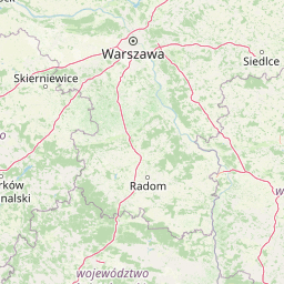
Map view of Moczydło Nature Reserve

Use this park location map to pinpoint Moczydło Nature Reserve in Poland, understand its exact geographic position, and read its mapped placement within the surrounding landscape more clearly.

Pigeon | © OpenStreetMap contributors

Location context for Moczydło Nature Reserve

Świętokrzyskie Voivodeship
Park atlas

Compare adjacent reserves and regional geography across the Świętokrzyskie hills.

Parks Near Rezerwat przyrody Moczydło and Surrounding Protected Landscapes

Browsing other protected areas near Rezerwat przyrody Moczydło reveals connected geological formations and regional conservation patterns throughout the Holy Cross Mountains. Extending the geographic review allows researchers to evaluate similar limestone terrain and historical mining landscapes across neighboring protected units.
Protected landscapeŚwiętokrzyskie Voivodeship
Mapped location lies within the park boundary#1 closest

Southwest

Chęcińsko-Kielecki Park Krajobrazowy: Protected Landscapes and Geological Atlas

Geographical overview of the Świętokrzyskie foothills in Poland

Located in the Świętokrzyskie Voivodeship, this protected area features a unique concentration of rocky hill summits, limestone caves, and forested corridors. The landscape serves as a vital transition zone, linking the regional capital of Kielce with traditional agricultural valleys and historic cultural landmarks. Map the terrain and understand the protected features that define this significant Polish landscape park.

Area
197.816 km²
Established
1996
Relief
Upland
Climate
Temperate
Protected landscapeŚwiętokrzyskie Voivodeship
About 10 km away#2 closest

Northeast

Suchedniowsko-Oblęgorski Park Krajobrazowy: A Protected Landscape in Świętokrzyskie

Geographic terrain, forest ecosystems, and industrial heritage

Located in the Świętokrzyskie Voivodeship, this protected area preserves significant forest stands and historic industrial remnants. The terrain captures the intersection of plateau geology and hill country, hosting the headwaters of the Bobrza and Krasna rivers within a culturally layered, heavily forested environment.

Area
198.95 km²
Established
1988
Relief
Mountain
Climate
Temperate
Nature reserveświętokrzyskie
About 12 km away#3 closest

West

Rezerwat przyrody Milechowy: Protected Nature Reserve and Karst Landscape Atlas

Exploration of forested ridges and rocky karst terrain in świętokrzyskie, Poland

Rezerwat przyrody Milechowy is a significant nature reserve located in the świętokrzyskie voivodeship, home to diverse ecological habitats ranging from dense woodland ridges to exposed rocky slopes. The area is defined by its karst landscape, featuring multiple caves and rock shelters, alongside rare xerothermic vegetation that flourishes in the warm, sun-exposed terrain of the Holy Cross Mountains region.

Area
1.323 km²
Established
1978
Relief
Upland
Climate
Temperate
Nature reserveświętokrzyskie
About 13 km away#4 closest

Northeast

Ostoja Wierzejska Nature Reserve: Protected Forest and Ridge Geography in Świętokrzyskie

Ecological corridors and rare fir forest habitat mapping

Uncover the landscape characteristics of Ostoja Wierzejska, a protected area in Poland featuring quartzite ridges and diverse forest ecosystems. The reserve acts as a crucial ecological link within the Masłowskie Range, sheltering mature tree stands, rare fungi, and specialized invertebrates that define the unique phytosociology of the Świętokrzyskie Mountains.

Area
2.25 km²
Established
2011
Relief
Mountain
Climate
Temperate
Protected landscapeŚwiętokrzyskie Voivodeship
About 21 km away#5 closest

East

Cisowsko-Orłowiński Park Krajobrazowy: Protected Landscape and Geological Atlas

Mapping biodiversity and Paleozoic formations in Świętokrzyskie, Poland

Cisowsko-Orłowiński Park Krajobrazowy stands as a center for biodiversity in southeastern Poland, protecting rare peat-bog forests and 200-year-old tree stands. This atlas profile highlights the park's distinct geological character, from the volcanic rock exposures at Sieraków to the fossil-rich sandstone cliffs at Zalesie, offering insight into the complex mosaic of the Góry Świętokrzyskie foothills.

Area
206.93 km²
Established
1988
Relief
Mountain
Climate
Temperate
Watercolor illustration of rolling hills with green forests in the foreground and purple, green, pink, and yellow mountain ranges in the background
National parkŚwiętokrzyskie Voivodeship
About 25 km away#6 closest

East

Świętokrzyski National Park: Protected Mountain Terrain in Świętokrzyskie Voivodeship

Geography and landscape mapping for Poland's oldest mountain range

Świętokrzyski National Park encompasses the highest ridges of the Świętokrzyskie Mountains, showcasing a landscape defined by expansive granite boulder fields and primeval fir forests. This atlas entry provides a detailed look at the park's topography, ranging from the prominent Łysica peak to the protected valley floors, highlighting the geological and biological diversity preserved within this central Polish sanctuary.

Area
76.26 km²
Established
1950
IUCN
II
Visitors
168K annual
National parkŚwiętokrzyskie Voivodeship
About 25 km away#7 closest

East

Świętokrzyski Park Narodowy: Protected Forests and Mountain Geography in Central Poland

A preserved landscape of ancient fir forests and rubble fields

Situated within the Świętokrzyskie Voivodeship, this protected area guards the Łysogóry range and its rare forest associations. The landscape is characterized by its dramatic gołoborza rubble fields and dense mixed-woodland terrain, providing a unique look into the natural geography of the region.

Area
76.26 km²
Established
1950
Visitors
168K annual
Relief
Mountain
Protected landscapeŚwiętokrzyskie Voivodeship
About 29 km away#8 closest

Southeast

Szaniecki Park Krajobrazowy: Protected Landscape Atlas and Regional Map Context

Exploring xerothermic habitats across the Ponidzie plateau

Szaniecki Park Krajobrazowy anchors conservation efforts across the Płaskowyż Szaniecki and the Garb Pińczowski ridge. This detailed profile tracks the regional geography, calcareous soil influence, and the protection of rare steppe flora within the broader Świętokrzyskie Voivodeship landscape framework.

Area
112.896 km²
Established
1986
Relief
Upland
Climate
Temperate

Common questions about visiting, size, designation, and location context for Moczydło Nature Reserve

Moczydło Nature Reserve FAQs for park facts, access, geography, and protected area context

Find quick answers about Moczydło Nature Reserve, including protected-area facts, park geography, trail and visitor context, and how the park fits into its surrounding country and regional landscape.
MoriAtlas Explorer

Continue Your Protected Areas Search Across the Global Atlas

Deepen your exploration by continuing the structured search for national parks and protected areas worldwide. Utilize the comprehensive filtering capabilities to compare different conservation landscapes and refine your understanding of global park geography. Discover more about the distribution and characteristics of protected natural areas.

Global natural geography