
Streams
Park geography
Structured data on terrain, elevation statistics, and regional physical features.
Mount Naomi Wilderness: Detailed Geographic Profile and Mapped Landscape Boundaries
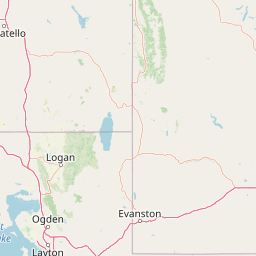
The geographic profile of Mount Naomi Wilderness encompasses 180.18 square kilometers of mountain terrain situated within the Wasatch Range of Utah. This data set maps internal features including High Creek Lake, Cherry Peak, and various stream networks that define the local topography. The landscape is characterized by alpine and montane environments reaching an elevation of 3040 meters.
Related tags
wilderness areamountainsalpine lakessubalpine meadowsconiferous forest
A high-elevation Wasatch wilderness of forested peaks, alpine lakes, and deep canyons in northern Utah.
Mount Naomi Wilderness
Mount Naomi Wilderness is a protected wilderness area in northeastern Utah, situated within the Uinta-Wasatch-Cache National Forest in Cache County. The wilderness spans tens of thousands of acres of mountainous terrain between the Logan River and the Utah-Idaho state line, just northeast of the city of Logan. The landscape is defined by forested ridges, high summits, and deeply cut canyons that descend from the Wasatch crest. Its signature feature is Naomi Peak, the highest point in the wilderness, surrounded by numerous other summits above nine thousand feet. Together these highlands create a classic Rocky Mountain-style environment of conifer forest, subalpine meadows, and rugged relief. Established in 1984 and managed by the U.S. Forest Service, Mount Naomi Wilderness preserves a representative slice of northern Utah's high-country ecosystems. The area is valued for outdoor recreation as much as for conservation, drawing hikers, campers, horseback riders, hunters, and wildlife watchers into one of the state's most scenic mountain settings.
- Location
- United States of America
- Park type
- Wildlife reserve
- Established
- 1984
- Area
- 180.2 km²
- Highest point
- 3,040 m
Location overview
Country and regional administrative context within the United States of America
Mount Naomi Wilderness Geography and Regional Location
Recorded location memberships place Mount Naomi Wilderness firmly within the United States of America and Utah. Official geographic records establish national administrative boundaries and status attributes without transboundary or coastal designations.
- Countries
- United States of America
- Regions
- Utah
- Primary location
- Utah
- Geographic setting
- Inland
Boundary and coordinates
Mapped protected area geometry and calculated surface metrics
Mount Naomi Wilderness Boundary Map and Geographic Extent
Interactive boundary geometry defines the spatial outline and overall protected extent of Mount Naomi Wilderness. Accompanying dimensional metrics outline the recorded land area, coordinate limits, and geographic span for analytical reference.
- Boundary area
- 180.3 km²
- Boundary perimeter
- 133.4 km
- Northernmost point
- 41.9994° N
- Southernmost point
- 41.7468° N
- Easternmost point
- 111.6339° W
- Westernmost point
- 111.785° W
- Geographic centre
- 41.8878° N, 111.7116° W
- North–south span
- 28.1 km
- East–west span
- 12.5 km
Elevation and terrain
Mountain relief metrics and recorded natural water and peak features
Mount Naomi Wilderness Terrain and Elevation Geography
Recorded elevation records place the highest point at 3040 meters across rugged mountain terrain. Associated natural feature cards list individual streams, peaks, and ranges located within the protected boundary.
- Maximum elevation
- 3,040 m
- Highest point
- 3,040 m
Selected named natural features
Streams
Beef Hollow
Mountain ranges
Wasatch Range
Streams
Little Left Hand Fork Creek
Streams
Birch Creek
Streams
Ole Hansen Hollow
Environmental setting
Alpine climate zones, montane forests, and mountain relief profiles
Mount Naomi Wilderness Environmental Setting and Landscape Classifications
Recorded mountain relief, alpine climate zones, and partial forest cover frame the physical setting of Mount Naomi Wilderness. Connected atlas destinations link these categories to broader regional geography and protected-area contexts.
- Relief
- Mountain
- Climate
- Alpine
- Water
- Minor water
- Forest cover
- Partial forest
- Seasonality
- Seasonal
Landscape features
Mountains · Valleys · Canyon · Forest · Lakes · Rivers
Habitat types
Montane forest · Alpine meadow
Park atlas
Compare adjacent mountainous terrain, high-country forests, and regional reserves
Explore Other Parks Near Mount Naomi Wilderness and Protected Landscapes
Browse protected areas and rugged high-country reserves situated close to Mount Naomi Wilderness. Examining surrounding mountain environments helps place northern Utah ecosystems within a wider regional geographic context.
Protected landscapeUnited States of America
About 22 km away#1 closest
Southwest

Wasatch-Cache National Forest Protected Area: Geography, Mountains, and Wilderness Mapping
Analyzing high-mountain terrain and watershed connectivity across the Intermountain West
Wasatch-Cache National Forest serves as a major ecological anchor in the United States. Its territory encompasses the iconic Wasatch Range, extensive designated wilderness zones, and alpine basins. The region provides critical watershed protection and supports diverse high-altitude ecosystems, from narrow, dissected ridges to broad, glaciated terrain throughout northern Utah and surrounding areas.
- Area
- 6,504.01 km²
- Established
- 1906
- Relief
- Mountain
- Access
- Easy access
Protected areaIdaho
66 km away#2 closest
Northwest
Curlew National Grassland: Protected Area Geography and Sagebrush Steppe Landscape in Idaho
Mapped regional geography and rangeland conservation context
Located in southeastern Idaho, Curlew National Grassland offers an expansive view of the Intermountain sagebrush steppe. This protected area provides a historical example of Depression-era land restoration and currently functions as a vital habitat for sagebrush-associated wildlife, showcasing the unique, rolling plains and semi-arid terrain characteristic of the northern Great Basin.
- Area
- 193.4 km²
- Established
- 1934
- Relief
- Upland
- Scope
- Terrestrial

Protected landscapeIdaho
98 km away#3 closest
Northwest
Sawtooth National Forest: Geographic Overview and Protected Mountain Boundaries
Central Idaho mountain systems and wilderness corridors
Spanning over two million acres, Sawtooth National Forest defines the heart of the Rocky Mountains in Idaho. This protected landscape contains a complex network of glacial basins, alpine lakes, and varied ecosystems ranging from arid sagebrush foothills to high-altitude peaks. Explore the internal boundaries, drainage systems, and structural geography of this significant wilderness area.
- Area
- 8,540.52 km²
- Established
- 1905
- Visitors
- 1.2M annual
- Relief
- Mountain
Wildlife reserveUtah
About 121 km away#4 closest
South
Mount Olympus Wilderness: Geographic Overview of the Iconic Wasatch Range Protected Landscape
Steep granite massif and alpine terrain in northern Utah
Explore the distinct topography of Mount Olympus Wilderness, a protected sanctuary in Utah featuring soaring granite outcrops and deep drainage systems. The park is anchored by a recognizable twin-peak silhouette that rises abruptly from the Salt Lake Valley, encompassing high alpine ridges and one of the deepest known cave systems in the United States within its rugged forested boundaries.
- Access
- Easy access
Wildlife reserveUtah
131 km away#5 closest
South
Lone Peak Wilderness: Protected Alpine Geography and Wasatch Range Map Insights
Rugged glacial terrain and granite summits in Northern Utah
Lone Peak Wilderness represents a dramatic intersection of high-mountain wilderness and urban geography. Rising from the Salt Lake and Utah Valleys, its alpine terrain features jagged granite peaks, persistent snowfields, and steep glacial canyons. This protected landscape remains a critical reference for understanding the ecological and topographical character of the central Wasatch Range and Utah's wilderness preservation history.
- Area
- 121.76 km²
- Established
- 1978
- IUCN
- Ib
- Relief
- Mountain
Wildlife reserveUtah
147 km away#6 closest
South
Mount Timpanogos Wilderness: Mapping the Protected Alpine Landscape and High Wasatch Terrain
An iconic Utah protected area within the northern Wasatch Range.
Mount Timpanogos Wilderness preserves a dramatic segment of the Wasatch Range, centering on an iconic summit that rises above glacial basins and forested slopes. This protected area offers a distinct study of alpine geology, featuring high-altitude cirques, steep ridges, and the prominent presence of Emerald Lake. As a critical piece of Utah wilderness, it anchors the skyline above the urban corridor, providing a concentrated look at regional mountain ecosystems and rugged natural terrain.
- Area
- 42.56 km²
- Established
- 1984
- IUCN
- Ib
- Relief
- Mountain
Protected areaWyoming
173 km away#7 closest
Southeast
Flaming Gorge National Recreation Area: Protected Reservoir and Canyon Landscape Atlas
High desert geography and canyon terrain on the Wyoming and Utah border.
Flaming Gorge National Recreation Area features a complex geography where the Green River carves through vivid red sandstone cliffs. This protected area integrates large-scale reservoir management with mountain forest slopes and diverse river corridors, creating a unique mapped landscape that reflects the geologic character of the intermountain West.
- Area
- 839.17 km²
- Established
- 1968
- Relief
- Upland
- Climate
- Arid
Wildlife reserveWyoming
177 km away#8 closest
North
Jedediah Smith Wilderness: Protected Alpine Terrain and Teton Range Geography
Glacially sculpted high-country basins in western Wyoming
Spanning the western face of the Teton Range, the Jedediah Smith Wilderness serves as a federally protected buffer for iconic mountain landscapes. The region features dramatic cirques, hanging valleys, and dense subalpine forest habitats, forming an essential, roadless link within the broader Greater Yellowstone Ecosystem. Explore the terrain features and structural geography that define this remote high-country wilderness area.
- Area
- 499.59 km²
- Established
- 1984
- IUCN
- Ib
- Relief
- Mountain
MoriAtlas Explorer
Continue Exploring the Geography and Mapped Boundaries of Mount Naomi Wilderness
Gain a deeper understanding of the mountainous terrain and protected ecosystems within Mount Naomi Wilderness. MoriAtlas provides a clear view of the ridges, canyons, and alpine lakes that shape this significant wilderness area in northern Utah, supporting refined geographic study and spatial analysis.
Browse next
Global natural geography
Explore related park routes
Explore MoriAtlas Global ParksBrowse All MoriAtlas ParksGlobal Park Map DiscoveryMoriAtlas: Browse All CountriesBrowse All MoriAtlas ContinentsNational Park Environment AtlasGrand Canyon National Park AtlasYellowstone National Park AtlasYosemite National Park Atlas and GeographySerengeti National Park AtlasGalápagos National Park Protected LandscapeBanff National Park Geography and AtlasKruger National Park Atlas EntryUluṟu-Kata Tjuṯa National Park AtlasExplore Uluru-Kata Tjuta National Park GeographyPlitvice Lakes National Park AtlasFiordland National Park Protected LandscapeGreat Smoky Mountains National Park AtlasAfghanistan National Parks and Protected AreasAlbania National Parks and Protected AreasAlgeria National Parks and Protected AreasAmerican Samoa National Parks and Protected AreasAndorra National Parks and Protected AreasAngola National Parks and Protected AreasAntarctica National Parks and Protected AreasAntigua and Barbuda Park List