Mori Atlas logo
Wildlife reserveMount Naomi Wilderness

Mapping the high-altitude ridges, subalpine lake basins, and rugged canyons of the Bear River Range

Mount Naomi Wilderness: An Atlas Exploration of Protected High-Country Landscapes in Northern Utah

Mount Naomi Wilderness protects a representative slice of high-country geography in northern Utah, characterized by a spine of nine-thousand-foot summits and dense conifer forests. This area encompasses a dramatic landscape of steep-walled canyons descending toward the Logan River, alongside secluded alpine basins like White Pine Lake and the accessible Tony Grove Lake. Visitors and map-focused observers can study the complex topographical relief and wildflower-rich meadows that define this significant Uinta-Wasatch-Cache National Forest wilderness.

wilderness areamountainsalpine lakessubalpine meadowsconiferous forestwildflower meadows

Mount Naomi Wilderness

Wildlife reserve

Park overview

Structured park overview, official facts, and landscape profile for Mount Naomi Wilderness

Mount Naomi Wilderness park facts, protected area profile, and essential visitor context

Review the core facts for Mount Naomi Wilderness, including designation, size, terrain, visitor scale, habitats, and operating context in one park-focused overview.

About Mount Naomi Wilderness

Mount Naomi Wilderness occupies a substantial block of the Bear River Range in northeastern Utah, forming part of the high backdrop to the Cache Valley and the city of Logan. The wilderness sits within the broader Uinta-Wasatch-Cache National Forest and is administered by the U.S. Forest Service under the protective framework of the National Wilderness Preservation System, established in 1984.

Geographically, the wilderness stretches from the upper Logan River drainage on its western side to the Utah-Idaho state line along its eastern margin. This position places it at the heart of one of Utah's most prominent northern mountain corridors, where forested highlands, glacial and periglacial landforms, and deeply incised canyons combine to create a varied high-country environment.

The defining topographic feature is Naomi Peak, which rises to nearly ten thousand feet and anchors the eastern portion of the wilderness. From this central high point, the terrain descends west into a maze of canyons, ridges, and forested drainages. Several other summits exceed nine thousand feet, reinforcing the impression of a continuous high-elevation landscape. Lakes occupy the basins beneath these peaks, with Tony Grove Lake offering one of the most accessible scenic destinations and White Pine Lake providing a more remote alternative reached only on foot.

Ecologically, the wilderness spans a range of elevations large enough to support distinct vegetation zones, from montane coniferous forest on the lower slopes through subalpine stands and into exposed alpine environments near the summits. The mix of open meadows, dense forest, rocky ridges, and cold lake basins supports a rich array of wildlife patterns typical of the northern Wasatch and Bear River Range.

Recreationally, the wilderness is a focal point for the Cache Valley and a wider regional audience. Its trail network serves day hikers seeking lake views, backpackers moving between basins, equestrians traveling forest roads and trails, and hunters pursuing game in the more remote drainages. The combination of wilderness designation and proximity to a growing regional population gives Mount Naomi Wilderness a dual role: as a preserved ecological landscape and as a key outdoor recreation resource for northern Utah.

Quick facts and research context for Mount Naomi Wilderness

Mount Naomi Wilderness is a federally designated wilderness of roughly 44,500 acres in Cache County, Utah, situated northeast of Logan and just west of the Idaho border. It lies within the larger Uinta-Wasatch-Cache National Forest and is administered by the U.S. Forest Service. The area was formally designated as wilderness in 1984 and is classified in the strictest U.S. wilderness category, reflecting its protected, undeveloped character.

The wilderness is dominated by mountainous terrain, with Naomi Peak as its highest summit and multiple additional peaks rising above nine thousand feet. Tony Grove Lake and the more remote White Pine Lake serve as focal destinations within the area, and the landscape combines woodland, alpine lake basins, wildflower meadows in summer, and steep canyon systems.

Protection and recognition

Examine terrestrial protection scope, designation history, and management parameters.

Mount Naomi Wilderness Protection Status and International Recognition Facts

Mount Naomi Wilderness maintains a documented terrestrial protection scope within its designated conservation framework. Structured facts compile official protection parameters, management details, and international recognition data where verified.

Protection details

Protection scope
Terrestrial
Transboundary protection
No
Park context

Deeper park guide and search-rich context for Mount Naomi Wilderness

Mount Naomi Wilderness history, landscape, wildlife, and travel context

Explore Mount Naomi Wilderness through its history, landscape character, ecosystems, wildlife, conservation priorities, cultural context, and seasonal travel timing in a structured park guide built for atlas discovery and search intent.

Why Mount Naomi Wilderness stands out

Mount Naomi Wilderness is best known for Naomi Peak, the defining summit that gives the area its name, and for the dense network of forested ridges and canyons that surround it. The wilderness showcases the northern Utah Wasatch in its wildest form: high-elevation conifer stands, subalpine lake basins such as Tony Grove Lake and White Pine Lake, and an unusually rugged eastern edge that drops toward the Bear River Range. It is also recognized as a destination where accessible front-country scenery meets genuinely remote backcountry. Hikers and equestrians can travel from relatively easy lakeside trails into steep, lightly trodden canyons, while summer brings one of the region's more striking wildflower displays across the meadows surrounding the higher lakes.

Mount Naomi Wilderness history and protected-area timeline

Mount Naomi Wilderness was formally designated as part of the U.S. National Wilderness Preservation System in 1984, placing its roughly 44,500 acres under the strictest category of federal land protection and ensuring its preserved, undeveloped character.

At the time of its designation, Mount Naomi was already part of the larger national forest context, embedded within what is now the Uinta-Wasatch-Cache National Forest. Its establishment as wilderness reflected a national effort to identify and protect representative high-country landscapes in the western United States, particularly landscapes that combined scenic, recreational, and ecological values.

Since 1984, the wilderness has been managed by the U.S. Forest Service, which oversees its trail network, access points, and natural resource conditions under the framework of the Wilderness Act. Its proximity to Utah State University and the city of Logan has helped make it one of the more heavily used wilderness areas in the region, while its designated status has kept its landscapes free from road building and most forms of development.

Mount Naomi Wilderness landscape and geographic character

Mount Naomi Wilderness is fundamentally a mountainous landscape, dominated by the high peaks and ridges of the Bear River Range. The wilderness is centered on Naomi Peak, which at nearly ten thousand feet forms the tallest point in the area, and includes a number of additional summits rising above nine thousand feet. These peaks create a continuous high-elevation skyline broken only by passes, saddles, and headwater valleys.

On the western side of the wilderness, the terrain falls away into a series of steep, deeply cut canyons draining toward the Logan River. These canyons add vertical relief and visual drama to the wilderness, breaking the forested slopes into a series of ribs and gullies that resist easy travel. The eastern edge of the wilderness is defined by the high crest itself, while the broader foothills and forested ridges fill in the middle elevations.

Lakes, basins, and meadows punctuate the high country. Tony Grove Lake, one of the most commonly visited destinations, sits in a striking cirque-like basin framed by slopes and rocky ridges. White Pine Lake, accessible only on foot, occupies a more remote setting. Between the lakes and the summits, the landscape transitions from subalpine openings to denser conifer stands, with wildflower-rich meadows emerging in the warmer months.

Mount Naomi Wilderness ecosystems, habitats, and plant life

The ecological character of Mount Naomi Wilderness reflects its position in the northern Wasatch and the broader Bear River Range, where elevation drives a clear zonation from forested foot slopes to exposed high peaks.

Lower and middle elevations are covered by montane coniferous forest, including stands of spruce, fir, and pine typical of the central Rocky Mountain and Great Basin high-country interface. These forests host a mix of closed canopy, semi-open ridges, and small meadows, providing structural diversity that supports a wide range of wildlife. As elevation increases, the vegetation thins into subalpine and alpine zones, with stunted trees, open rock, and seasonal wildflower displays giving way to bare summits near Naomi Peak.

Moisture collects in the basins and saddles between peaks, sustaining lake environments, wet meadows, and grassy openings. These wet pockets are particularly important in an otherwise forested terrain, providing food and cover for both wildlife and pollinators. In late summer, the meadows around Tony Grove Lake and similar basins erupt in dense displays of wildflowers, marking one of the defining seasonal rhythms of the area.

The mixture of forest, meadow, rock, and water gives the wilderness a layered ecological identity. Rather than a single uniform habitat, Mount Naomi offers a mosaic that shifts rapidly with elevation and aspect, producing pockets of aspen groves, dark conifer stands, sun-warmed south-facing slopes, and shaded north-facing ravines within relatively short distances.

Mount Naomi Wilderness wildlife and species highlights

Mount Naomi Wilderness supports the wildlife communities typical of Utah's high-country forests. Its mix of coniferous forest, subalpine meadows, rocky ridges, and lake basins provides habitat for both resident species and seasonal migrants, with elevation serving as a major structuring influence.

Mule deer are among the most visible and important ungulates in the wilderness, using the canyons, meadows, and forested slopes throughout the year, and forming a focal species for the area's hunting tradition. Elk also occur in parts of the range, while smaller mammals such as squirrels, chipmunks, snowshoe hares, and various mustelids occupy the forest understory. Predators in the broader ecosystem include mountain lions, bobcats, coyotes, and black bears, moving through the canyons and forested corridors.

Birdlife reflects the same altitudinal layering. The high forests host species typical of montane and subalpine coniferous environments, while the meadows and lake margins attract a broader community of songbirds and summer visitors. Raptors patrol the open ridges and canyon edges, taking advantage of the thermal updrafts along the Bear River Range. Around Tony Grove Lake and White Pine Lake, water-associated species add an aquatic dimension to the wilderness's bird list.

In late summer, the meadows and forested edges become especially active with pollinators and associated birdlife, complementing the visible wildflower displays. Together, the wildlife patterns at Mount Naomi Wilderness reinforce its identity as a working high-country ecosystem rather than simply a scenic backdrop.

Mount Naomi Wilderness conservation status and protection priorities

Mount Naomi Wilderness is conserved under the strongest category of U.S. wilderness protection, classified as IUCN Category Ib and managed to preserve its undeveloped, roadless character. The 1984 designation placed roughly 44,500 acres under the framework of the National Wilderness Preservation System, ensuring that its forests, lakes, ridges, and canyons remain free from new road construction, motorized use, and most forms of development.

Its conservation significance lies in the way it preserves a representative stretch of the northern Wasatch high country. The wilderness protects a continuous gradient of ecosystems, from montane conifer forest up to alpine ridgelines, along with associated water resources such as Tony Grove Lake and White Pine Lake. These lakes and their surrounding meadows function as small but important refuges of subalpine habitat within an otherwise forested matrix.

Because the wilderness sits close to a growing regional population, its protected status is especially important for maintaining wildlife corridors, water quality in the Logan River watershed, and the long-term integrity of the high-elevation forests. The combination of wilderness designation within a national forest framework means the area benefits both from the strict protections of wilderness policy and from the broader conservation mandate of the Uinta-Wasatch-Cache National Forest.

Mount Naomi Wilderness cultural meaning and human context

Mount Naomi Wilderness is rooted in the landscape identity of Cache Valley and the broader northern Utah region. The surrounding valleys were settled in the nineteenth century by Mormon pioneers, and the mountains of the wilderness have long served as a defining high-country backdrop for communities such as Logan, Richmond, and nearby towns.

The wilderness enters local cultural life as a shared space for outdoor recreation, ranching heritage, hunting traditions, and family outings that span generations. Trails originally used for stock travel, prospecting, and timber access gradually became recreational corridors as the area transitioned into formal national forest and wilderness status. The high-country lakes and meadows, including Tony Grove Lake, have long functioned as seasonal gathering places for the people of Cache Valley.

This regional relationship gives Mount Naomi Wilderness a strong sense of place beyond its formal conservation designation. For residents of northern Utah and southeastern Idaho, the wilderness is both a protected landscape and a familiar mountain neighbor, woven into local traditions of outdoor life.

Top sights and standout views in Mount Naomi Wilderness

Mount Naomi Wilderness's strongest highlights center on its summit landscapes, its alpine lake basins, and the unusually steep canyon country along its western edge. Naomi Peak anchors the area at nearly ten thousand feet, surrounded by multiple additional nine-thousand-foot summits that give the wilderness a continuous high-country spine.

The lakes are an equally important highlight. Tony Grove Lake offers one of the most photogenic and accessible destinations in the area, framed by dense forest and rocky ridges, while White Pine Lake provides a more secluded alternative reached only by hiking trails. The mid- to late-summer wildflower displays in the meadows around these lakes create a seasonal visual peak that draws both casual visitors and photographers.

Equally distinctive is the network of canyons descending toward the Logan River, which give the wilderness much of its rugged character. Combined with the trail system, equestrian routes, and hunting access, these highlights support the area's role as one of northern Utah's most complete high-country wilderness experiences.

Best time to visit Mount Naomi Wilderness

Late July through early September is widely regarded as the most rewarding period to experience Mount Naomi Wilderness, when high-country trails are largely free of seasonal snow and the meadows around Tony Grove Lake and White Pine Lake burst into their annual wildflower displays. This window offers the best combination of accessible trails, warm temperatures, and full seasonal scenery.

Summer is also the main season for the area's characteristic recreational mix of day hiking, overnight backpacking, horseback riding, and wildlife watching, with the lakes serving as natural focal points for visitors. Lower elevations can still draw visitors into early autumn, when cooler temperatures and changing forest light add a quieter mood to the canyons and ridges.

Winter and early spring bring heavy snow to the higher elevations, which closes most trail access and removes much of the area's accessible character. While the snowy season has its own stark appeal, the full range of the wilderness's highlights is generally experienced during the warmer months.

Monthly climate preview

Long-term temperature ranges and precipitation rhythm from representative coordinates

Mount Naomi Wilderness Climate Normals and Monthly Weather Patterns

Mount Naomi Wilderness records distinct annual temperature shifts alongside measured monthly precipitation variations across the representative coordinate. Reviewing the complete twelve-month climatology dataset reveals broader meteorological trends for detailed analysis.
Annual mean7 °C
-6 °C22 °C
Jan-6°
Feb-4°
Mar
Apr
May11°
Jun17°
Jul22°
Aug21°
Sep15°
Oct
Nov
Dec-6°
Warmest month
July

22.2 °C

Coolest month
January

-6.2 °C

Wettest month
May

2 mm/day

Driest month
July

0.6 mm/day

Park location guide

Geography guide, regional context, and park location map for Mount Naomi Wilderness

Mount Naomi Wilderness park geography, regions, and map view in United States of America

Understand where Mount Naomi Wilderness sits in United States of America through a broader geographic reading of the surrounding landscape, nearby location context, and its mapped position within the national park landscape.

How Mount Naomi Wilderness fits into United States of America

The United States of America is a federal presidential republic and one of the world's largest countries by area and population. It consists of 50 states across a vast territory spanning multiple time zones, with its capital in Washington, D.C. and largest city in New York City. The nation has a diverse economy, influential political system, and significant cultural and military presence globally.

Wider geography shaping Mount Naomi Wilderness in United States of America

The United States occupies a vast territory in North America, bordered by Canada to the north and Mexico to the south. The 48 contiguous states stretch from the Atlantic to the Pacific Ocean, while Alaska occupies the northwestern region and Hawaii is an archipelago in the Pacific. The country encompasses diverse terrain including the Rocky Mountains, Appalachian Mountains, Great Plains, and extensive river systems.

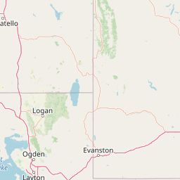
Map view of Mount Naomi Wilderness

Use this park location map to pinpoint Mount Naomi Wilderness in United States of America, understand its exact geographic position, and read its mapped placement within the surrounding landscape more clearly.

Pigeon | © OpenStreetMap contributors

Location context for Mount Naomi Wilderness

Utah
Natural feature types

Explore the Geographic Landmark Index for Mount Naomi Wilderness

Discover the physical composition of Mount Naomi Wilderness by navigating our collection of mapped natural features. This MoriAtlas resource helps users trace the high-country topography, from prominent mountain peaks to secluded lake basins, within this protected region of northern Utah.
Recorded earthquake history

Review the Historical Earthquake Catalogue for Mount Naomi Wilderness

Open the dedicated seismic records catalogue to examine historical earthquake data associated with Mount Naomi Wilderness. This MoriAtlas resource maps recorded events against the park boundary to provide a clear, factual view of regional seismic history in the Bear River Range.

Mount Naomi Wilderness Earthquake History

Catalogued events

66 events

Strongest magnitude

Magnitude 4.9

Most recent event

Jul 23, 2026

This history includes earthquakes recorded inside the park or within 50 km of its borders

Park atlas

Compare adjacent mountainous terrain, high-country forests, and regional reserves

Explore Other Parks Near Mount Naomi Wilderness and Protected Landscapes

Browse protected areas and rugged high-country reserves situated close to Mount Naomi Wilderness. Examining surrounding mountain environments helps place northern Utah ecosystems within a wider regional geographic context.
Protected landscapeUnited States of America
About 22 km away#1 closest

Southwest

Wasatch-Cache National Forest Protected Area: Geography, Mountains, and Wilderness Mapping

Analyzing high-mountain terrain and watershed connectivity across the Intermountain West

Wasatch-Cache National Forest serves as a major ecological anchor in the United States. Its territory encompasses the iconic Wasatch Range, extensive designated wilderness zones, and alpine basins. The region provides critical watershed protection and supports diverse high-altitude ecosystems, from narrow, dissected ridges to broad, glaciated terrain throughout northern Utah and surrounding areas.

Area
6,504.01 km²
Established
1906
Relief
Mountain
Access
Easy access
Protected areaIdaho
66 km away#2 closest

Northwest

Curlew National Grassland: Protected Area Geography and Sagebrush Steppe Landscape in Idaho

Mapped regional geography and rangeland conservation context

Located in southeastern Idaho, Curlew National Grassland offers an expansive view of the Intermountain sagebrush steppe. This protected area provides a historical example of Depression-era land restoration and currently functions as a vital habitat for sagebrush-associated wildlife, showcasing the unique, rolling plains and semi-arid terrain characteristic of the northern Great Basin.

Area
193.4 km²
Established
1934
Relief
Upland
Scope
Terrestrial
Watercolor painting of a calm lake surrounded by forested shores and distant mountains, depicted in soft pastel tones.
Protected landscapeIdaho
98 km away#3 closest

Northwest

Sawtooth National Forest: Geographic Overview and Protected Mountain Boundaries

Central Idaho mountain systems and wilderness corridors

Spanning over two million acres, Sawtooth National Forest defines the heart of the Rocky Mountains in Idaho. This protected landscape contains a complex network of glacial basins, alpine lakes, and varied ecosystems ranging from arid sagebrush foothills to high-altitude peaks. Explore the internal boundaries, drainage systems, and structural geography of this significant wilderness area.

Area
8,540.52 km²
Established
1905
Visitors
1.2M annual
Relief
Mountain
A pale watercolor painting showing a wide, panoramic view of layered mountains with light green and muted red hills in the foreground and clusters of pine trees.
Wildlife reserveUtah
About 121 km away#4 closest

South

Mount Olympus Wilderness: Geographic Overview of the Iconic Wasatch Range Protected Landscape

Steep granite massif and alpine terrain in northern Utah

Explore the distinct topography of Mount Olympus Wilderness, a protected sanctuary in Utah featuring soaring granite outcrops and deep drainage systems. The park is anchored by a recognizable twin-peak silhouette that rises abruptly from the Salt Lake Valley, encompassing high alpine ridges and one of the deepest known cave systems in the United States within its rugged forested boundaries.

Access
Easy access
Wildlife reserveUtah
131 km away#5 closest

South

Lone Peak Wilderness: Protected Alpine Geography and Wasatch Range Map Insights

Rugged glacial terrain and granite summits in Northern Utah

Lone Peak Wilderness represents a dramatic intersection of high-mountain wilderness and urban geography. Rising from the Salt Lake and Utah Valleys, its alpine terrain features jagged granite peaks, persistent snowfields, and steep glacial canyons. This protected landscape remains a critical reference for understanding the ecological and topographical character of the central Wasatch Range and Utah's wilderness preservation history.

Area
121.76 km²
Established
1978
IUCN
Ib
Relief
Mountain
A soft watercolor illustration depicting layered green hills in the foreground with faint mountain outlines in the background against a white background.
Wildlife reserveUtah
147 km away#6 closest

South

Mount Timpanogos Wilderness: Mapping the Protected Alpine Landscape and High Wasatch Terrain

An iconic Utah protected area within the northern Wasatch Range.

Mount Timpanogos Wilderness preserves a dramatic segment of the Wasatch Range, centering on an iconic summit that rises above glacial basins and forested slopes. This protected area offers a distinct study of alpine geology, featuring high-altitude cirques, steep ridges, and the prominent presence of Emerald Lake. As a critical piece of Utah wilderness, it anchors the skyline above the urban corridor, providing a concentrated look at regional mountain ecosystems and rugged natural terrain.

Area
42.56 km²
Established
1984
IUCN
Ib
Relief
Mountain
A watercolor painting showing a stylized landscape with a light blue lake, soft green rolling hills, and hints of red rock cliffs against a white background.
Protected areaWyoming
173 km away#7 closest

Southeast

Flaming Gorge National Recreation Area: Protected Reservoir and Canyon Landscape Atlas

High desert geography and canyon terrain on the Wyoming and Utah border.

Flaming Gorge National Recreation Area features a complex geography where the Green River carves through vivid red sandstone cliffs. This protected area integrates large-scale reservoir management with mountain forest slopes and diverse river corridors, creating a unique mapped landscape that reflects the geologic character of the intermountain West.

Area
839.17 km²
Established
1968
Relief
Upland
Climate
Arid
Wildlife reserveWyoming
177 km away#8 closest

North

Jedediah Smith Wilderness: Protected Alpine Terrain and Teton Range Geography

Glacially sculpted high-country basins in western Wyoming

Spanning the western face of the Teton Range, the Jedediah Smith Wilderness serves as a federally protected buffer for iconic mountain landscapes. The region features dramatic cirques, hanging valleys, and dense subalpine forest habitats, forming an essential, roadless link within the broader Greater Yellowstone Ecosystem. Explore the terrain features and structural geography that define this remote high-country wilderness area.

Area
499.59 km²
Established
1984
IUCN
Ib
Relief
Mountain

Common questions about visiting, size, designation, and location context for Mount Naomi Wilderness

Mount Naomi Wilderness FAQs for park facts, access, geography, and protected area context

Find quick answers about Mount Naomi Wilderness, including protected-area facts, park geography, trail and visitor context, and how the park fits into its surrounding country and regional landscape.
MoriAtlas Explorer

Continue Your Protected Areas Search Across the Global Atlas

Deepen your exploration by continuing the structured search for national parks and protected areas worldwide. Utilize the comprehensive filtering capabilities to compare different conservation landscapes and refine your understanding of global park geography. Discover more about the distribution and characteristics of protected natural areas.

Global natural geography