
Mori Atlas logo
Nature reserveMühlbachtal

A study of near-natural stream corridors, medieval water management, and diverse riparian meadows

Mühlbachtal Nature Reserve and the Protected Valley Landscapes of the Hochsauerlandkreis Region

(Naturschutzgebiet Unteres Mühlenbachtal)

The Mühlbachtal nature reserve serves as a vital geographic anchor within the Hochsauerlandkreis, preserving a distinctive valley landscape defined by the meandering Mühlenbach stream. This protected area integrates complex riparian ecosystems with a rare medieval water-catchment system that once powered monastic life near Rumbeck. Through its mix of alder-lined banks, wet meadows, and deciduous woodland, the valley offers a clear window into the regional landscape character and its long-standing ecological history.

nature reserveprotected valleystream landscapeorchid meadowsmixed woodlandalder galleries
A graphic illustration depicting a tiered waterfall cascading down between steep cliff faces, surrounded by stylized evergreen trees and ferns in a nature-focused color palette.

Mühlbachtal

Nature reserve

Park overview

Structured park overview, official facts, and landscape profile for Mühlbachtal

Mühlbachtal park facts, protected area profile, and essential visitor context

Review the core facts for Mühlbachtal, including designation, size, terrain, visitor scale, habitats, and operating context in one park-focused overview.

About Mühlbachtal

The Mühlbachtal is a compact valley landscape on the edge of the Arnsberg forest country in the Sauerland, where a small stream, mixed woodland and historic meadowland come together within a tightly defined protected area. The nature reserve, formally called Naturschutzgebiet Unteres Mühlenbachtal, covers only a few hectares, but it compresses a surprising range of habitats, including near-natural stream sections, alder galleries, wet meadows, mixed birch-alder-beech forest, small fishponds and a reed-fringed pond.

A defining quality of the valley is the continuity between its ecological character and its cultural-historical layers. The same meadows and pond hollows that today support orchids and dragonflies were once the working landscape of Kloster Rumbeck, whose Premonstratensian community shaped the valley's hydrology through ponds, mill channels and a sophisticated hillside water-collection system. After secularization the valley passed into state forest ownership, and it is this layered land-use history, monastic, agricultural and silvicultural, that gives the protected area much of its identity.

In practical terms, the Mühlbachtal functions as both a conservation site and a low-key cultural site. Its management prescriptions explicitly link ecological protection with the preservation of cloister-era earthworks, and its poetry trail has turned the old monastic pathways into a year-round cultural landscape feature, used by roughly fifteen thousand visitors annually.

Quick facts and research context for Mühlbachtal

The Mühlbachtal is located near the village of Rumbeck, a district of Arnsberg in the Hochsauerlandkreis of North Rhine-Westphalia. The nature reserve covering the lower part of the valley was first designated in 1998 and was renewed under a revised landscape plan in 2021, at which point it was reduced in size to about 6.9 hectares.

The valley sits at the interface between village land, pastures and forest, with the Mühlenbach running through it as a near-natural, meandering stream. The protected stretch is valued for its alder galleries, wet meadows with orchids, mixed deciduous woodland, and historic earthworks from the former monastic watermill and pond system of Kloster Rumbeck.

Park context

Deeper park guide and search-rich context for Mühlbachtal

Mühlbachtal history, landscape, wildlife, and travel context

Explore Mühlbachtal through its history, landscape character, ecosystems, wildlife, conservation priorities, cultural context, and seasonal travel timing in a structured park guide built for atlas discovery and search intent.

Why Mühlbachtal stands out

The Mühlbachtal is best known for combining a small but ecologically rich nature reserve with a remarkable medieval water management heritage. The hillside water-catchment system built by the nuns of Kloster Rumbeck to feed their fishponds and mills is a rare construction type in Germany, comparable in its engineering to elements recorded at Kloster Maulbronn. Ecologically, the valley is recognized for its near-natural, meandering stream, alder-lined banks, orchid-rich wet meadows, mixed deciduous woodland, and the presence of characteristic valley species such as the kingfisher, the grey wagtail, the white-throated dipper and the wren.
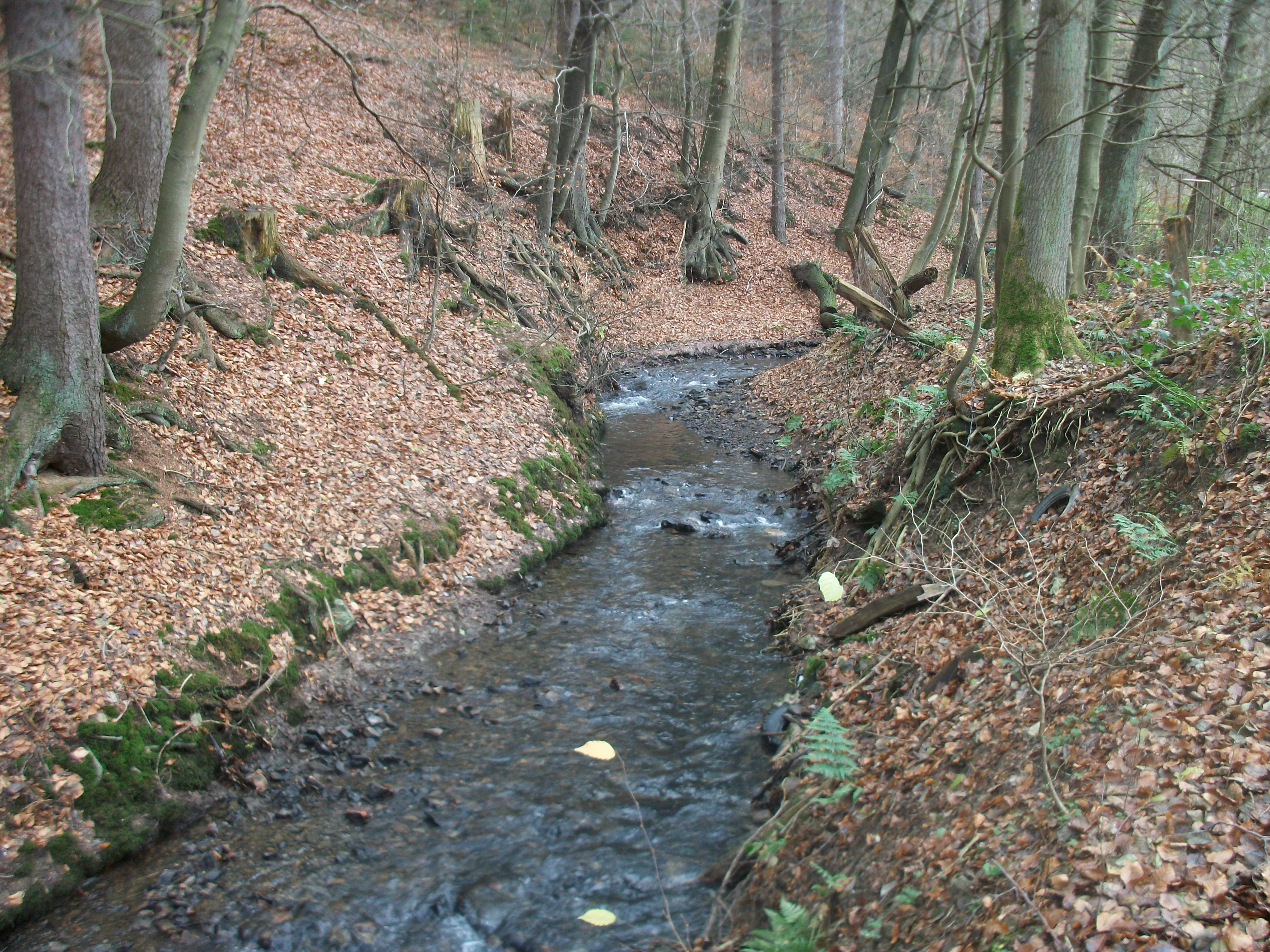
A small narrow stream flows through a deciduous forest with leaf-covered banks and exposed tree roots.
The Mühlbach stream flowing through the forested valley of the Mühlbachtal nature reserve.

Mühlbachtal history and protected-area timeline

The cultural history of the Mühlbachtal is inseparable from Kloster Rumbeck, the Premonstratensian convent that held the surrounding Waldwiesental through the Middle Ages and the early modern period. The nuns ran intensive forestry, water use and fish-farming operations in the valley, supporting their kitchen through pond-based fish culture and operating at least one glassworks in the woods. A linked network of ponds and dams powered grain mills, oil mills, sawmills and even a small iron forge.

The valley's most distinctive historical feature is a hillside water-catchment system, a network of channels cut along the slopes to collect and divert groundwater and runoff into the valley's ponds and mill channels during dry periods. Such systems are rare in Germany, with the only widely cited parallel found at Kloster Maulbronn. The catchment is now recognized as an archaeological monument and remains legible in the landscape alongside the older dam and charcoal-burning relicts.

After secularization and the transfer of the former Duchy of Westphalia to Prussia, the valley passed into state forest administration, a transition that ended its monastic management regime and shifted it toward forestry. The nature reserve designation, first established in 1998 by the Hochsauerlandkreis district council and renewed under the 2021 landscape plan, marks the most recent chapter in this long history of layered land use.

Mühlbachtal landscape and geographic character

The Mühlbachtal is a short valley segment where the Mühlenbach flows in a clear Sohlental form, a valley whose floor and sides meet broadly rather than through steep, narrow walls. The lower part of the valley opens between the village of Rumbeck and the adjoining forest, with pastures used as cattle grazing giving it a partly open, partly enclosed feel.

The stream itself defines the visual and physical spine of the valley, meandering along its floor through alder-lined banks. To either side, the valley supports a patchwork of wet meadows, where scrubby greenland fallows dominate the central section, mixed woodland of birch, alder and beech along the edges, and a stand of spruce further south. Small artificial fishponds and a more natural, reed-choked pond introduce standing-water elements into an otherwise stream-led landscape.

The valley's topography is modest rather than dramatic, but it reads clearly as a sequence of small landscape rooms: village edge, open pasture, wooded amphitheater, pond cluster, meadow, brookside. The medieval earthworks from the monastic pond and mill system are still visible in the relief, lending historical depth to what is otherwise a quiet, contained valley landscape.

Mühlbachtal ecosystems, habitats, and plant life

Ecologically, the Mühlbachtal functions as a small but structurally rich valley mosaic. The Mühlenbach is the central ecological axis, running with a near-natural charac­ter and hosting a self-reproducing trout population. Its banks are framed by alder, a typical riparian species for Sauerland brooks and one that helps stabilize the moist, nutrient-rich bankside.

Around the stream, the habitats vary quickly over short distances. The middle of the protected stretch is dominated by greenland fallows and wet meadow fragments, with a notably diverse orchid flora on the damper patches. Toward the south, the stream passes through a mixed stand of birch, alder, beech and spruce, reflecting both natural forest tendencies and the long history of forest management in the area. Standing water is provided by several fishponds of more recent, non-natural origin, alongside a small, near-natural pond that has largely silted up with reed growth.

Floristically, more than 160 plant species have been recorded in the area, including several orchid species that give the wet meadow zones particular conservation interest. The combination of free-flowing stream, riparian woodland, wet meadow and small-scale standing water is what gives the valley its ecological coherence, even within a compact protected footprint.

The formal protection statement for the area emphasizes the rarity, distinctive character and beauty of the landscape, and the designation specifically targets the preservation of a structurally rich valley stretch, the orchid-bearing wet meadows, and the integrity of habitat types protected under German federal nature conservation law.

Mühlbachtal wildlife and species highlights

The wildlife profile of the Mühlbachtal reflects its character as a small, structurally diverse valley. The stream is home to a healthy population of brown trout, while the ponds and slow-flowing stretches support rich dragonfly communities, particularly around the reed-fringed pond and along quieter bank margins.

The valley's birdlife is closely tied to its stream and bankside vegetation. The kingfisher, the grey wagtail and the white-throated dipper are regularly recorded along the Mühlenbach, while the wren inhabits the denser scrub and woodland understory. Together these species signal a functioning riparian habitat and a degree of naturalness that is increasingly rare in heavily managed lowland and sub-mountainous landscapes.

Larger mammal species are not specifically highlighted in the available sources, which tend to emphasize the aquatic and meadow-associated fauna. The valley's role for wildlife is therefore less about charismatic large species and more about supporting the smaller, often overlooked communities of stream fish, riparian birds, dragonflies and meadow insects that depend on intact small-scale valley habitats.

Mühlbachtal conservation status and protection priorities

The Mühlbachtal is protected in two nested layers. The lower portion of the valley carries formal nature reserve (Naturschutzgebiet) status, while the broader valley upstream is designated as the Landschaftsschutzgebiet Mühlenbachtal, a landscape protection area covering a wider buffer of pastoral and forested land around Rumbeck. The nature reserve was first established in 1998 under the original Arnsberg landscape plan and was renewed with a revised name and reduced area in 2021.

The stated purpose of the reserve is to protect, maintain and develop a structurally rich, at least partially open valley stretch with near-natural, alder-lined stream sections and adjacent wet meadow habitats. The designation also explicitly aims to preserve the cultural-historical value of the Kloster Rumbeck pond and irrigation system, and to support the coherence of the European Natura 2000 network of protected areas.

Additional management prescriptions link the conservation regime to specific habitat types protected under Germany's federal nature conservation act, and prohibit the use of the valley's still waters for fishing. The protection package positions the Mühlbachtal as both an ecological site, valuable for its orchids, trout and riparian birds, and a cultural-ecological site, where monastic earthworks are themselves treated as integral components of the protected landscape.

Management is also explicitly aimed at gradually converting non-native tree stands into extensive grassland or replacing them with native woodland species, reinforcing the valley's long-term trajectory toward a more natural habitat mosaic.

Mühlbachtal cultural meaning and human context

The Mühlbachtal carries a distinctive cultural imprint from Kloster Rumbeck, whose Premonstratensian nuns shaped the valley through forestry, fish-farming, milling and a sophisticated water-catchment system. The cloister's economic footprint, ponds, dams, mill leats, charcoal platforms and water channels, is still partly legible in the present landscape and is formally recognized as an archaeological monument.

After secularization and the transition to Prussian state forest ownership, the valley's cultural identity shifted from a monastic working landscape to a forested cultural landscape associated with the Arnsberg state forestry tradition. The literary society of Arnsberg, the local heritage association and the state forestry service now jointly maintain the Poesiepfad, a seasonal poetry trail where nature-themed poems are installed along the valley's paths and refreshed four times a year.

The poetry trail has become the most visible contemporary cultural layer on the valley, attracting around fifteen thousand visitors a year and reframing the Mühlbachtal as a place where literature, ecology and the cloister-era earthworks coexist. The result is a landscape whose cultural value is not just historical but actively renewed through seasonal programming.

Top sights and standout views in Mühlbachtal

The Mühlbachtal combines a compact nature reserve with a layered cultural-historical identity, anchored by the surviving engineering of the Premonstratensian nuns of Kloster Rumbeck. Its hillside water-catchment system is a nationally rare feature, paralleled in Germany only at Kloster Maulbronn.

Ecologically, the valley stands out for the density of habitats packed into a small area: meandering trout stream, alder galleries, orchid-rich wet meadows, mixed deciduous woodland, small fishponds and a reed-framed pond. The presence of kingfisher, grey wagtail, white-throated dipper and wren reinforces the conservation value of these habitats.

The valley's seasonal poetry trail adds a distinctive cultural-ecological touchpoint, attracting roughly fifteen thousand visitors annually and turning the old monastic pathways into an active, year-round literary and nature landscape.

Best time to visit Mühlbachtal

The Mühlbachtal's seasonal character is shaped by its deciduous woodland, wet meadows and seasonal programming. Spring is a particularly rewarding period, when the wet meadows come alive with orchids and the streamside vegetation greens up, while the fresh leaf canopy makes the valley feel enclosed and intimate. Summer offers the richest display of dragonflies around the ponds and slow-flowing stream sections, along with the longest daylight hours for walking the trails.

Autumn brings the classic mixed-color display of the Sauerland beech, birch and alder stands, and the poetry trail is rotated to a season-appropriate selection of poems at each change of season. Winter visits offer a quieter, more open reading of the valley, where the bare deciduous cover exposes the medieval earthworks, pond hollows and the meandering course of the Mühlenbach in the landscape.

Monthly climate preview

Long-term representative monthly averages for temperature and precipitation in Mühlbachtal

Mühlbachtal Climate Normals, Annual Temperature and Precipitation Rhythm

Mühlbachtal exhibits a measured annual temperature and precipitation rhythm ranging from sub-zero winter lows to warm summer maximums based on historical baseline records. Examining the complete twelve-month climate profile provides deeper monthly comparisons for understanding local environmental conditions.
Annual mean9 °C
0 °C18 °C
Jan
Feb
Mar
Apr
May12°
Jun16°
Jul18°
Aug18°
Sep14°
Oct
Nov
Dec
Warmest month
July

18.2 °C

Coolest month
January

0.3 °C

Wettest month
December

2.7 mm/day

Driest month
April

1.7 mm/day

Park location guide

Geography guide, regional context, and park location map for Mühlbachtal

Mühlbachtal park geography, regions, and map view in Germany

Understand where Mühlbachtal sits in Germany through a broader geographic reading of the surrounding landscape, nearby location context, and its mapped position within the national park landscape.

How Mühlbachtal fits into Germany

Germany is a federal republic in Western and Central Europe with a population of over 83 million across sixteen constituent states. It is Europe's largest economy by nominal GDP and a major global exporter and importer. The capital is Berlin, and the country borders Denmark, Poland, Czech Republic, Austria, Switzerland, France, Luxembourg, Belgium, and the Netherlands.

Wider geography shaping Mühlbachtal in Germany

Germany is located in Western and Central Europe, spanning 357,022 km². It borders Denmark to the north, Poland and the Czech Republic to the east, Austria and Switzerland to the south, and France, Luxembourg, Belgium, and the Netherlands to the west. The country has coastlines on the Baltic Sea and North Sea to the north, with the Alps located in the southern region.

Map view of Mühlbachtal

Use this park location map to pinpoint Mühlbachtal in Germany, understand its exact geographic position, and read its mapped placement within the surrounding landscape more clearly.

Pigeon | © OpenStreetMap contributors

Location context for Mühlbachtal

HochsauerlandkreisNorth Rhine-Westphalia

Visualizing stream habitats, meadow vegetation, and monastic waterworks across the protected valley

Mühlbachtal Landscape Photography and Protected Valley Scenery Visual Guide

Visual documentation of Mühlbachtal reveals the intricate terrain of its protected stream course, alder galleries, and orchid meadows. Examining these field photographs provides a clear geographical understanding of the valley environment and its historical monastic water network.

A small narrow stream flows through a deciduous forest with leaf-covered banks and exposed tree roots.

Park atlas

Compare adjacent valley reserves and regional protected landscapes in Sauerland.

Explore Protected Areas and Parks Near Mühlbachtal

Browsing other protected areas near Mühlbachtal reveals the broader ecological spread of valley reserves and stream landscapes across the surrounding region. Comparing adjacent terrain helps trace connected conservation corridors and similar valley habitats throughout the Hochsauerlandkreis territory.
Nature reserveGermany
About 2.8 km away#1 closest

Northeast

Schatthangwald Egge Nature Reserve: Geographic Overview and Protected Forest Boundaries

A preserved oak-beech slope forest in Germany

Focusing on the northern Ruhr valley, this nature reserve protects a shade-dense oak-beech slope and essential deadwood habitats. Explore the mapped terrain of this Arnsberg-based area, where strict conservation rules prioritize natural forest turnover and the protection of forest interior conditions near the regional rail infrastructure.

Area
0.093 km²
Established
2021
Relief
Upland
Scope
Terrestrial
Nature reserveNorth Rhine-Westphalia
About 3 km away#2 closest

Southeast

Naturschutzgebiet Olper Höhe - Winterseite: Protected Upland Woodland in North Rhine-Westphalia

Old-growth forest terrain and historic charcoal-burning landscape relics

Situated on the slopes of the Olper Höhe, this nature reserve protects a structurally rich mix of oak and beech woodland. Beyond its ecological importance as a habitat for rare species, the site preserves historic charcoal-kiln platforms that link the modern forest to its long-standing cultural and forestry history in the Hochsauerland district.

Area
0.259 km²
Established
1994
Relief
Upland
Climate
Temperate
Nature reserveNorth Rhine-Westphalia
About 3.3 km away#3 closest

South

Naturschutzgebiet Oberlauf der Rümmecke: Protected Landscape and Brook Valley Geography

Protected Nature Reserve in the Sauerland Highlands

This nature reserve encompasses the upper valley of the Rümmecke brook, showcasing an alder-fringed stream and a unique sphagnum alder swamp at its source. Situated in the municipal area of Sundern, the reserve serves as a critical wetland habitat amidst the spruce-dominated landscape of the Sauerland region, offering deep insight into the local ecology and terrain.

Established
1993
Relief
Upland
Climate
Temperate
Scope
Terrestrial
Nature reserveHochsauerlandkreis
About 4.1 km away#4 closest

Northwest

Naturschutzgebiet Schlossberg Osthang: Protected Forest Geography in Hochsauerlandkreis

A specialized limestone slope debris nature reserve overlooking the Ruhr valley.

Spanning a small but ecologically vital area, Naturschutzgebiet Schlossberg Osthang protects a rare limestone slope debris forest. The site features extreme topography and thin calcareous soils that support specialized mollusks and plant communities, marking it as a critical refugial biotope within the broader Arnsberg landscape plan.

Area
0.003 km²
Established
2021
Relief
Upland
Climate
Temperate
Watercolor illustration of a calm lake surrounded by low, rolling green hills and a forested shoreline with wildflower foreground.
Protected landscapeHochsauerlandkreis
About 4.4 km away#5 closest

Northeast

Landschaftsschutzgebiet Arnsberg: Protected Landscape and Regional Geography

Forested hills and historical cultural landscape in Hochsauerlandkreis

Landschaftsschutzgebiet Arnsberg encompasses a complex network of 219 separate sub-areas across the rolling hills of the Sauerland region. This protected landscape preserves important ecological functions through its vast spruce and beech forests while buffering nearby natural reserves. Its mosaic structure and historical mining relics offer a unique view into the development of the forested landscape bordering the city of Arnsberg.

Area
57.958 km²
Established
1998
Relief
Upland
Climate
Temperate
Nature reserveHochsauerlandkreis
About 4.9 km away#6 closest

Southwest

Naturschutzgebiet Oberlauf des Hellefelder Baches: Protected Stream and Valley Geography

A forest-focused nature reserve in the Hochsauerlandkreis

Discover the geographic layout of Naturschutzgebiet Oberlauf des Hellefelder Baches, a nature reserve in the northern Sauerland. This protected area centers on the upper reaches of the Hellefelder Bach, preserving wooded ravines and critical headwater springs within a broader matrix of regional forest management.

Area
0.089 km²
Established
2019
Relief
Upland
Scope
Terrestrial
A watercolor illustration of a serene landscape with rolling green hills, a small body of water, and silhouetted tree lines under a soft pastel sky.
Nature reserveNorth Rhine-Westphalia
About 5.1 km away#7 closest

South

Naturschutzgebiet Odin / Hardt: Protected Nature Reserve and Sauerland Upland Geography

Mapped woodland landscape in the North Rhine-Westphalia region.

The Naturschutzgebiet Odin / Hardt nature reserve represents a unique segment of the Sauerland landscape, defined by its well-preserved birch and oak coppice woodland and historic silica slate quarry. Located near Sundern, the reserve serves as an ecologically significant reference site for traditional land management and upland forest succession patterns in Germany.

Area
0.119 km²
Established
1993
Relief
Upland
Scope
Terrestrial
Nature reserveHochsauerlandkreis
About 6 km away#8 closest

West

Naturschutzgebiet Oberes Walpketal: Protected Nature Reserve and Valley Geography

Brook valley habitat in the Hochsauerlandkreis region of Germany.

Located in the Sundern area, Naturschutzgebiet Oberes Walpketal encompasses a 5.6-hectare valley corridor shaped by the upper Walpke stream. The site serves as a vital protected area, showcasing the ecological transition from moist alder riparian forests to upland beech stands typical of the Sauerland landscape. This record outlines the reserve's topography, stream-side composition, and its function as a stepping-stone biotope.

Area
0.056 km²
Established
2019
Relief
Upland
Climate
Temperate

Common questions about visiting, size, designation, and location context for Mühlbachtal

Mühlbachtal FAQs for park facts, access, geography, and protected area context

Find quick answers about Mühlbachtal, including protected-area facts, park geography, trail and visitor context, and how the park fits into its surrounding country and regional landscape.
MoriAtlas Explorer

Continue Your Protected Areas Search Across the Global Atlas

Deepen your exploration by continuing the structured search for national parks and protected areas worldwide. Utilize the comprehensive filtering capabilities to compare different conservation landscapes and refine your understanding of global park geography. Discover more about the distribution and characteristics of protected natural areas.

Global natural geography