


Mori Atlas logo
Nature reserveNaturschutzgebiet Odin / Hardt

Mapped boundaries and regional geography of a historic birch and oak coppice woodland landscape.

Naturschutzgebiet Odin / Hardt: Protected Nature Reserve in the North Rhine-Westphalia Sauerland

(Naturschutzgebiet „Odin / Hardt" (HSK-079))

Naturschutzgebiet Odin / Hardt is a protected nature reserve located along the Hardt ridge in the northern Sauerland region of North Rhine-Westphalia. This 11.9 hectare site preserves a traditional coppice woodland, known as a Niederwald, where birch and oak thrive on acidic soils alongside heather and juniper. The protected area features a former silica slate quarry, illustrating the intersection of cultural woodland history and geological terrain within the German uplands.

low mountain reservebirch-oak coppice woodlandNiederwaldheath habitatjuniper ridgeacid soil woodland
An illustrative art piece showing a mountain valley with steep cliffs, a waterfall on the right, and evergreen and birch trees in the foreground.

Naturschutzgebiet Odin / Hardt

Nature reserve

Park overview

Structured park overview, official facts, and landscape profile for Naturschutzgebiet Odin / Hardt

Naturschutzgebiet Odin / Hardt park facts, protected area profile, and essential visitor context

Review the core facts for Naturschutzgebiet Odin / Hardt, including designation, size, terrain, visitor scale, habitats, and operating context in one park-focused overview.

About Naturschutzgebiet Odin / Hardt

Naturschutzgebiet Odin / Hardt is a compact nature reserve in the northern Sauerland, a low mountain region that forms part of the wider German central uplands. Although it covers only about 11.9 hectares, the reserve concentrates a striking combination of ecological and cultural features that make it disproportionately important for conservation understanding in the region.

At the heart of the protected area is a traditional birch and oak coppice woodland, the Niederwald, that grows on the north-facing slope of the long, narrow Hardt ridge. Because of the long history of selective cutting and regrowth, the trees display a dwarfed, multi-stemmed form rather than the tall, single-trunk canopy typical of modern commercial forests. The forest composition includes sessile and pedunculate oak, silver birch, scattered beech, and occasional alder buckthorn and rowan. On the crest of the ridge, juniper appears alongside the woodland, signaling the acid, nutrient-poor soil conditions that define much of the reserve.

The understorey of the reserve is as distinctive as its tree layer. Dense heaths of dwarf shrubs, including heather, bilberry, and cowberry, cover the ground between the stunted trees, while grasses such as woodrush and common pipe grass dominate other areas. In late spring, lily of the valley flowers appear in the undergrowth, and in summer the meadow lousewort blooms. Ground-dwelling lichens colonize bare soil along path embankments, branches and twigs around the woodland are draped with epiphytic lichens, and old tree stumps support thick moss cushions. Bracken fern adds local patches of taller green growth within the otherwise open forest floor.

In addition to its woodland and heath character, the reserve contains a former Lydit, or silica slate, quarry. This historical extractive feature adds a geological dimension to the protected area and creates small open habitat niches within the surrounding forest. Together, these features place the reserve among the best-conserved Niederwald examples in the Hochsauerland district, while also illustrating how cultural woodland practices and mineral history intersect with present-day ecological value.

Quick facts and research context for Naturschutzgebiet Odin / Hardt

The reserve covers roughly 11.9 hectares within the city of Sundern, Sauerland, in the Hochsauerland district of North Rhine-Westphalia. It was first designated as a nature reserve in 1993 with the original landscape plan for Sundern, initially covering 5.3 hectares, and was expanded and re-designated when that plan was renewed. The protected area is surrounded by the broader Sundern landscape protection zone and shares its boundary with the adjacent Meschede nature reserve around the Niederwälder bei Visbeck.

Protection and recognition

Terrestrial protection status, management scope, and documented recognition history

Naturschutzgebiet Odin / Hardt Protection Status and Official Designated Area Records

Naturschutzgebiet Odin / Hardt maintains a recorded terrestrial protection status within the global atlas framework. Detailed records compile documented management scope, designation history, and available recognition data for this protected area.

Protection details

Protection scope
Terrestrial
Park context

Deeper park guide and search-rich context for Naturschutzgebiet Odin / Hardt

Naturschutzgebiet Odin / Hardt history, landscape, wildlife, and travel context

Explore Naturschutzgebiet Odin / Hardt through its history, landscape character, ecosystems, wildlife, conservation priorities, cultural context, and seasonal travel timing in a structured park guide built for atlas discovery and search intent.

Why Naturschutzgebiet Odin / Hardt stands out

Odin / Hardt is best known for sheltering one of the best-preserved coppice woodlands of the Hochsauerland district. The reserve's defining feature is a stunted, multi-stemmed birch and oak Niederwald growing on the north-facing slope of the Hardt ridge, accompanied by juniper, heather, bilberry, and cowberry. The nature reserve is also notable for containing a former Lydit (silica slate) quarry, which represents an additional cultural and geological feature. Together, the traditional woodland ecosystem and the historic quarry make the small reserve a recognized reference site for both ancient woodland management and post-quarry habitat development in the Sauerland.
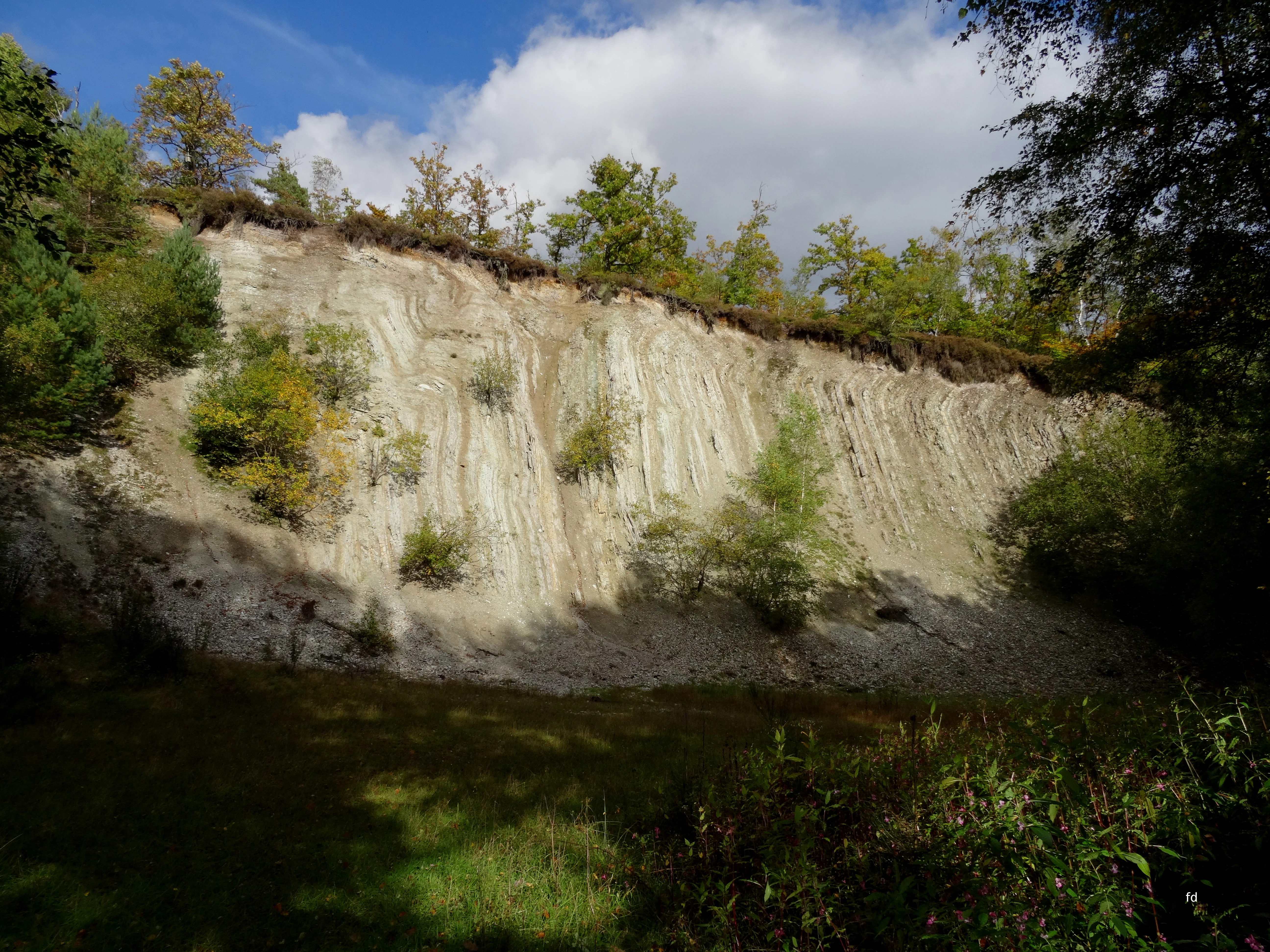
A steep, light-colored marl quarry cliff face topped with dense green trees and vegetation, viewed from the forest floor.
The marl quarry site within the Naturschutzgebiet Odin / Hardt, showcasing its distinct geological profile.

Naturschutzgebiet Odin / Hardt history and protected-area timeline

The Hardt ridge and its surrounding landscape have a long history of human interaction, shaped by traditional Niederwald management and small-scale mineral extraction. The most visible historical features within today's reserve are the stunted, multi-stemmed coppice woodland and the former Lydit or silica slate quarry, both traces of past land use that now contribute to current ecological value.

The formal protection of the area began in 1993, when the Buchkreis of the Hochsauerland district first designated a 5.3-hectare zone around the Odin / Hardt ridge as a nature reserve through the original landscape plan for Sundern. At that stage, the reserve recognized the rarity, distinctive character, and beauty of the woodland system, terminology that remains part of the standard justification for nature protection under German conservation law.

When the Sundern landscape plan was revisited and renewed, the reserve was re-designated and significantly enlarged, reaching its current approximate area of 11.9 hectares. This expansion reflected a growing appreciation of the ecological importance of the woodland, its associated heath communities, and the geological features of the site. Today, the reserve sits within the broader Sundern landscape protection zone and connects directly across the municipal boundary with the neighboring nature reserve of Niederwälder bei Visbeck on the Meschede side, strengthening its role within a wider network of protected low mountain habitats in the region.

Naturschutzgebiet Odin / Hardt landscape and geographic character

The landscape of Odin / Hardt is shaped by the long, narrow Hardt ridge, a typical feature of the northern Sauerland low mountains. The protected area sits on the northern flank of this ridge, where sloping terrain and acid soils combine to create conditions that favor open, sun-dappled woodland rather than closed high forest. The ridge profile and the north-facing exposure help produce the cooler, moister microclimate that supports the dense moss, lichen, and dwarf shrub communities found in much of the reserve.

On the crest of the Hardt ridge, the forest thins out and juniper, heather, and associated heath plants take over, giving parts of the skylined ridge a near-open character despite the small size of the area. Below the crest, the shallow, acidic soils reflect the underlying geology of the Sauerland, a region historically known for slate and related siliceous rocks. The former Lydit, or silica slate, quarry visible within the reserve illustrates this geological character and introduces small open rock surfaces and disturbed ground into an otherwise wooded setting.

Although the reserve is too small to host large-scale landforms, the way the woodland, heath openings, exposed slopes, and quarry site combine creates an unusually varied micro-landscape within just a few hectares. This local diversity is central to the reserve's value as a representative example of the rich ecological gradients typical of the Sauerland uplands.

Naturschutzgebiet Odin / Hardt ecosystems, habitats, and plant life

The nature reserve protects one of the best-conserved examples of a birch and oak coppice woodland in the Hochsauerland district. The woodland is dominated by sessile oak, pedunculate oak, and silver birch, with a few beech trees mixed in and isolated occurrences of alder buckthorn, rowan, juniper, and holly. Due to traditional cutting regimes, the oaks and birches tend to grow as short, multi-stemmed individuals rather than as tall, well-formed trees, producing an open light-filled canopy that supports a rich ground flora.

The ground layer reflects the acidic, nutrient-poor soils typical of the area. Heaths of dwarf shrubs and grasses blanket much of the woodland floor, with abundant bilberry, cowberry, and heather, alongside woodrushes and common pipe grass. Bracken fern appears in localized patches, while the late spring brings flowering lily of the valley and summer brings the meadow lousewort, contributing seasonal botanical interest. Old root plates and path embankments host terrestrial lichens, while branches and twigs carry epiphytic lichens that reflect the relatively unpolluted air of the area.

The heath-like communities on the ridge crest, with juniper interspersed between the heather and bilberry, are characteristic of upland habitats in the region and are preserved here as part of the protected forest system. Together, the coppice trees, dwarf shrub understorey, lichen communities, and quarry exposures form a cohesive but layered habitat mosaic within a very small area.

Naturschutzgebiet Odin / Hardt wildlife and species highlights

The wildlife profile of Odin / Hardt is closely linked to its mosaic of open woodland, dwarf shrub heaths, and former quarry ground. The structure of the Niederwald, with its stunted trees and gaps between trees, creates favorable conditions for insects and invertebrates associated with warm, sunny forest clearings, while the dense heather, bilberry, and juniper provide food and shelter for pollinators and other small animals. Moss cushions on old stumps and lichen-covered branches add further microhabitat value.

Although the source material for the reserve does not provide detailed species inventories, the protected status of the area reflects the regional importance of such habitats for supporting woodland-dependent birdlife, typical upland bird communities, and a range of invertebrates that depend on the continuity of traditional woodland management. The reserve's connection to the larger Sundern landscape protection zone and to the adjacent Meschede Niederwälder bei Visbeck reserve adds further ecological value by linking it to neighboring woodlands.

Naturschutzgebiet Odin / Hardt conservation status and protection priorities

The conservation significance of Odin / Hardt rests on its role as one of the most intact remaining birch and oak coppice woodlands in the Hochsauerland district. Such Niederwald systems are themselves a product of centuries of cultural management, and their modern conservation value lies in the combination of traditional woodland structure, acid-soil heath communities, and the associated flora and fauna that depend on long continuity of habitat.

The reserve was first designated in 1993 through the original Sundern landscape plan, then re-designated and expanded when that plan was renewed. The protection order itself cites rarity, distinctive character, and beauty as the basis for the designation, in line with general German nature reserve criteria. The fact that the wooded core is recognized as one of the best-preserved Niederwald stands in the district gives the reserve an outsized conservation weight relative to its small size.

Beyond the woodland itself, the inclusion of the former Lydit quarry extends the conservation focus to include geological and post-industrial habitat features. The reserve's position within the wider Sundern landscape protection zone, and its direct connection across the municipal boundary to the Niederwälder bei Visbeck reserve in Meschede, supports a broader landscape approach to conserving the historic woodland heritage of the Sauerland.

Naturschutzgebiet Odin / Hardt cultural meaning and human context

The cultural context of Odin / Hardt is rooted in centuries of traditional woodland use in the Sauerland. The stunted, multi-stemmed form of the oaks and birches is the visible result of historic Niederwald management, a rotational coppicing practice that once supplied firewood, charcoal, and small timber across much of central Europe. This living record of historical land use is itself part of the cultural landscape of the region.

The former Lydit or silica slate quarry within the reserve adds another layer to this cultural story. Silica slate extraction was a minor but locally important industry in parts of the Sauerland, and the surviving opening is a reminder of the small-scale mineral workings that shaped the rural economy alongside farming and forestry. Together, the managed woodland and the quarry illustrate how past human activity continues to define both the visible character and the ecological identity of the protected area.

Top sights and standout views in Naturschutzgebiet Odin / Hardt

Among the standout features of Odin / Hardt are its designation as one of the best-preserved Niederwald sites in the Hochsauerland district, the unusual combination of birch and oak coppice trees with juniper and heather understorey, and the presence of a former Lydit quarry at the heart of the protected zone. The reserve also functions as a connector between the Sundern landscape protection zone and the Niederwälder bei Visbeck reserve in neighboring Meschede.

Other notable qualities include the rich ground flora of bilberry, cowberry, heather, lily of the valley, and meadow lousewort, as well as the diverse lichen and moss communities that reflect the clean forest environment and traditional management. The result is a small but ecologically layered reserve that tells a clear story about the interplay of cultural woodland practices and natural upland habitats.

Best time to visit Naturschutzgebiet Odin / Hardt

The reserve can be appreciated across much of the year, but late spring and early summer are particularly rewarding. In late spring, lily of the valley blooms in the woodland understorey, while summer brings the flowering of meadow lousewort and the full visual expression of the heather, bilberry, and cowberry communities beneath the open coppice canopy. Autumn, when the bilberry leaves take on reddish hues and the heather continues to color the ridge crest, also offers a quieter and visually distinctive experience. Winter visits tend to emphasize the structural character of the stunted, multi-stemmed trees and the open feel of the dwarf shrub heath on the ridge top.

Monthly climate preview

Long-term representative point measurements for temperature and precipitation by month

Naturschutzgebiet Odin / Hardt Climate Normals and Annual Temperature Rhythm

Recorded coordinates for Naturschutzgebiet Odin / Hardt establish a multi-year baseline tracking mean monthly temperatures from near freezing up to warm summer maximums alongside steady precipitation rates. Reviewing the complete twelve-month climate profile reveals precise monthly variations and long-term temperature normals across the protected area.
Annual mean9 °C
0 °C18 °C
Jan
Feb
Mar
Apr
May12°
Jun16°
Jul18°
Aug18°
Sep14°
Oct
Nov
Dec
Warmest month
July

18.2 °C

Coolest month
January

0.3 °C

Wettest month
December

2.7 mm/day

Driest month
April

1.7 mm/day

Park location guide

Geography guide, regional context, and park location map for Naturschutzgebiet Odin / Hardt

Naturschutzgebiet Odin / Hardt park geography, regions, and map view in Germany

Understand where Naturschutzgebiet Odin / Hardt sits in Germany through a broader geographic reading of the surrounding landscape, nearby location context, and its mapped position within the national park landscape.

How Naturschutzgebiet Odin / Hardt fits into Germany

Germany is a federal republic in Western and Central Europe with a population of over 83 million across sixteen constituent states. It is Europe's largest economy by nominal GDP and a major global exporter and importer. The capital is Berlin, and the country borders Denmark, Poland, Czech Republic, Austria, Switzerland, France, Luxembourg, Belgium, and the Netherlands.

Wider geography shaping Naturschutzgebiet Odin / Hardt in Germany

Germany is located in Western and Central Europe, spanning 357,022 km². It borders Denmark to the north, Poland and the Czech Republic to the east, Austria and Switzerland to the south, and France, Luxembourg, Belgium, and the Netherlands to the west. The country has coastlines on the Baltic Sea and North Sea to the north, with the Alps located in the southern region.

Map view of Naturschutzgebiet Odin / Hardt

Use this park location map to pinpoint Naturschutzgebiet Odin / Hardt in Germany, understand its exact geographic position, and read its mapped placement within the surrounding landscape more clearly.

Pigeon | © OpenStreetMap contributors

Location context for Naturschutzgebiet Odin / Hardt

North Rhine-Westphalia

Visual exploration of birch and oak coppice woodlands, ridge terrain, and historic quarry habitats

Naturschutzgebiet Odin / Hardt Landscapes, Scenery, and Protected Area Photos

Visual documentation of Naturschutzgebiet Odin / Hardt reveals the distinct character of traditional birch and oak coppice woodlands along the Hardt ridge. Detailed photography captures the open forest canopy, juniper undergrowth, and geological formations that define this Sauerland reserve.

A steep, light-colored marl quarry cliff face topped with dense green trees and vegetation, viewed from the forest floor.

A dirt trail winds along the edge of a light-filled birch forest in a nature reserve, with scattered branches and fallen leaves on the ground.

Park atlas

Compare adjacent upland reserves and regional protected landscapes across the Sauerland

Other Parks Near Naturschutzgebiet Odin / Hardt and Surrounding Protected Areas

Browsing other parks near Naturschutzgebiet Odin / Hardt reveals connected woodland reserves and ancient coppice landscapes across the Sauerland uplands. Comparing adjacent protected areas helps place local low mountain topography and regional conservation history into a broader geographic perspective.
Nature reserveNorth Rhine-Westphalia
About 2.2 km away#1 closest

Northwest

Naturschutzgebiet Oberlauf der Rümmecke: Protected Landscape and Brook Valley Geography

Protected Nature Reserve in the Sauerland Highlands

This nature reserve encompasses the upper valley of the Rümmecke brook, showcasing an alder-fringed stream and a unique sphagnum alder swamp at its source. Situated in the municipal area of Sundern, the reserve serves as a critical wetland habitat amidst the spruce-dominated landscape of the Sauerland region, offering deep insight into the local ecology and terrain.

Established
1993
Relief
Upland
Climate
Temperate
Scope
Terrestrial
Nature reserveNorth Rhine-Westphalia
About 4.4 km away#2 closest

Northeast

Naturschutzgebiet Olper Höhe - Winterseite: Protected Upland Woodland in North Rhine-Westphalia

Old-growth forest terrain and historic charcoal-burning landscape relics

Situated on the slopes of the Olper Höhe, this nature reserve protects a structurally rich mix of oak and beech woodland. Beyond its ecological importance as a habitat for rare species, the site preserves historic charcoal-kiln platforms that link the modern forest to its long-standing cultural and forestry history in the Hochsauerland district.

Area
0.259 km²
Established
1994
Relief
Upland
Climate
Temperate
Nature reserveHochsauerlandkreis
About 4.4 km away#3 closest

Northwest

Naturschutzgebiet Oberlauf des Hellefelder Baches: Protected Stream and Valley Geography

A forest-focused nature reserve in the Hochsauerlandkreis

Discover the geographic layout of Naturschutzgebiet Oberlauf des Hellefelder Baches, a nature reserve in the northern Sauerland. This protected area centers on the upper reaches of the Hellefelder Bach, preserving wooded ravines and critical headwater springs within a broader matrix of regional forest management.

Area
0.089 km²
Established
2019
Relief
Upland
Scope
Terrestrial
A soft, watercolor painting depicting a winding stream flowing through a gentle green valley with rolling hills in the background.
Nature reserveHochsauerlandkreis
About 5.1 km away#4 closest

North

Mühlbachtal Nature Reserve and the Protected Valley Landscapes of Hochsauerlandkreis, Germany

A riparian valley landscape defined by medieval water management and stream ecology

This protected valley in the Hochsauerlandkreis serves as a case study in landscape continuity, linking a meandering trout stream to centuries of monastic engineering. The reserve showcases a mosaic of alder galleries, orchid meadows, and mixed deciduous woods that characterize the local geography while highlighting the cultural layering inherent in this German nature reserve.

Area
0.069 km²
Established
1998
Water
Major water bodies
Season
Year-round
Nature reserveHochsauerlandkreis
About 6 km away#5 closest

Southwest

Naturschutzgebiet Schatthangwald Hohe Liete: Protected Forest Geography and Map Context

A native deciduous forest remnant in the Hochsauerlandkreis uplands

Covering a steep, east-facing mid-slope, Naturschutzgebiet Schatthangwald Hohe Liete represents an essential remnant of original Sauerland woodland. This protected reserve provides a rare visual and ecological contrast to the surrounding industrial spruce plantations by maintaining a shaded, fern-rich, and gorge-like forest environment.

Area
0.009 km²
Established
1993
Relief
Upland
Scope
Terrestrial
Nature reserveGermany
About 6.9 km away#6 closest

North

Schatthangwald Egge Nature Reserve: Geographic Overview and Protected Forest Boundaries

A preserved oak-beech slope forest in Germany

Focusing on the northern Ruhr valley, this nature reserve protects a shade-dense oak-beech slope and essential deadwood habitats. Explore the mapped terrain of this Arnsberg-based area, where strict conservation rules prioritize natural forest turnover and the protection of forest interior conditions near the regional rail infrastructure.

Area
0.093 km²
Established
2021
Relief
Upland
Scope
Terrestrial
Nature reserveHochsauerlandkreis
About 7.1 km away#7 closest

Northwest

Naturschutzgebiet Oberes Walpketal: Protected Nature Reserve and Valley Geography

Brook valley habitat in the Hochsauerlandkreis region of Germany.

Located in the Sundern area, Naturschutzgebiet Oberes Walpketal encompasses a 5.6-hectare valley corridor shaped by the upper Walpke stream. The site serves as a vital protected area, showcasing the ecological transition from moist alder riparian forests to upland beech stands typical of the Sauerland landscape. This record outlines the reserve's topography, stream-side composition, and its function as a stepping-stone biotope.

Area
0.056 km²
Established
2019
Relief
Upland
Climate
Temperate
Nature reserveHochsauerlandkreis
About 7.5 km away#8 closest

West

Naturschutzgebiet Schatthangwald Röhre Protected Nature Reserve in Hochsauerlandkreis

Geographic overview of limestone forests and karst cave systems

Spanning 5.6 hectares, Naturschutzgebiet Schatthangwald Röhre illustrates a dense concentration of calcareous habitats. The area features a complex intersection of beech forest, abandoned limestone quarry floors, and significant subterranean features within the Röhr river valley context.

Area
0.056 km²
Established
1993
Relief
Upland
Scope
Terrestrial

Common questions about visiting, size, designation, and location context for Naturschutzgebiet Odin / Hardt

Naturschutzgebiet Odin / Hardt FAQs for park facts, access, geography, and protected area context

Find quick answers about Naturschutzgebiet Odin / Hardt, including protected-area facts, park geography, trail and visitor context, and how the park fits into its surrounding country and regional landscape.
MoriAtlas Explorer

Continue Your Protected Areas Search Across the Global Atlas

Deepen your exploration by continuing the structured search for national parks and protected areas worldwide. Utilize the comprehensive filtering capabilities to compare different conservation landscapes and refine your understanding of global park geography. Discover more about the distribution and characteristics of protected natural areas.

Global natural geography