

Mori Atlas logo
National parkNamdapha National Park

Understand the mapped boundaries and regional geography of this protected area in Arunachal Pradesh.

Namdapha National Park: A National Park Detailed Map and Protected Landscape Atlas Entry

Namdapha National Park represents a significant protected natural area within the region of Arunachal Pradesh, India. This page provides detailed geographic context, focusing on the park's mapped boundaries and its identity as a national park for atlas-style exploration. Users can gain a clear understanding of its landscape context and its place within the broader geography of the region, facilitating structured discovery of this protected territory.

Eastern HimalayasBiodiversity HotspotTiger ReserveLowland RainforestAlpine EnvironmentsBirdwatching

Namdapha National Park

National park

Park overview

Structured park overview, official facts, and landscape profile for Namdapha National Park

Namdapha National Park park facts, protected area profile, and essential visitor context
Review the core facts for Namdapha National Park, including designation, size, terrain, visitor scale, habitats, and operating context in one park-focused overview.

About Namdapha National Park

Namdapha National Park stands as one of India's most ecologically significant protected areas, encompassing a remarkable diversity of ecosystems within its 1,985 square kilometer expanse in the far northeastern corner of the country. The park occupies a pivotal position in the Eastern Himalayas, where the mountainous terrain creates a complex mosaic of habitats ranging from tropical lowland rainforests at elevations as low as 200 meters to alpine meadows above 4,500 meters. This extraordinary altitudinal range supports a continuum of vegetation zones that includes dipterocarp forests, tropical evergreen formations, moist deciduous woodlands, temperate broadleaf and mixed forests, coniferous stands, and finally alpine vegetation communities. The presence of the Noa Dihing River, which originates at the Chaukan Pass on the Indo-Myanmar border and traverses the park from east to west, adds further ecological complexity by creating riparian corridors and influencing local moisture regimes. The park's location at the interface between the Mishmi Hills and the Patkai range places it at a biogeographic crossroads that has facilitated the evolution of numerous endemic species and the accumulation of species from diverse geographic origins.

Quick facts and research context for Namdapha National Park

Namdapha National Park covers 1,985.23 km² in Arunachal Pradesh, India, near the Myanmar border. The park spans an elevation range from 200 to 4,571 meters, supporting tropical evergreen forests at lower elevations transitioning through temperate broadleaf and mixed forests to alpine vegetation at higher altitudes. The Noa Dihing River flows through the park from east to west, originating at the Chaukan Pass on the Indo-Myanmar border. The park was originally declared a wildlife sanctuary in 1972, achieved national park status in 1983, and was designated a tiger reserve in the same year. Its name derives from the Singpho language, combining 'nam' meaning water and 'dapha' meaning origin.

Park context

Deeper park guide and search-rich context for Namdapha National Park

Namdapha National Park history, landscape, wildlife, and travel context
Explore Namdapha National Park through its history, landscape character, ecosystems, wildlife, conservation priorities, cultural context, and seasonal travel timing in a structured park guide built for atlas discovery and search intent.

Why Namdapha National Park stands out

Namdapha is best known for its extraordinary biodiversity and the remarkable climatic extremes it encompasses within a single protected area. The park harbors the northernmost lowland evergreen rainforests in the world, a distinction that makes it globally significant for tropical rainforest conservation at unusually high latitudes. It is one of only a few places on Earth where four pantherine species coexist: the tiger, leopard, snow leopard, and clouded leopard. The park is also the sole known habitat of the critically endangered Namdapha flying squirrel, which has not been recorded since 1981. With approximately 425 bird species including six hornbill varieties, and exceptional Lepidoptera diversity featuring rare butterflies such as the koh-i-noor and East Himalayan purple emperor, Namdapha represents an irreplaceable repository of Himalayan biodiversity.

Namdapha National Park history and protected-area timeline

Namdapha's protected area status evolved through several formal designations reflecting growing recognition of its ecological significance. The area was first declared a wildlife sanctuary in 1972, establishing initial legal protection for its rich biodiversity. In 1983, the sanctuary was upgraded to national park status, providing stronger conservation safeguards for the area's unique ecosystems. In the same year, Namdapha was included in India's Project Tiger initiative, becoming a designated tiger reserve and gaining additional resources for wildlife protection and management. The park's name originates from the Singpho language, spoken by local indigenous communities in the region, combining the words 'nam' meaning water and 'dapha' meaning origin, reflecting the area's significance as a watershed. In 2024, the park was declared an Eco-Sensitive Zone, adding another layer of environmental protection that regulates activities in surrounding areas to minimize human impact on the protected ecosystem. The park is governed jointly by the Government of Arunachal Pradesh and the Government of India, reflecting the joint responsibility for managing this nationally significant conservation area.

Namdapha National Park landscape and geographic character

The physical landscape of Namdapha National Park is characterized by dramatic topographical complexity resulting from its position between two major mountain ranges. The Dapha Bum range of the Mishmi Hills forms the northern boundary, while the Patkai range defines the southern margin of the park, creating a mountainous corridor that funnels ecological influences between the Himalayan and Indo-Burman biogeographic regions. The park encompasses elevations ranging from 200 meters in the valley floors to 4,571 meters at the highest peaks, representing one of the most extreme elevation ranges within any single protected area in India. The terrain features steep ridges, deep valleys, and cascading streams that have carved distinctive landforms throughout the park. The Noa Dihing River serves as the principal drainage feature, flowing eastward to westward across the park and providing crucial water resources for both wildlife and local communities. Above 2,700 meters, seasonal snow occurs between December and March, adding a winter dimension to the high-altitude landscape that influences both vegetation patterns and wildlife behavior.

Namdapha National Park ecosystems, habitats, and plant life

The ecological character of Namdapha is defined by its extraordinary range of habitats and the exceptional biodiversity they support. As part of the Mizoram-Manipur-Kachin rain forests ecoregion, the park contains extensive dipterocarp forests that represent the northwestern extent of this tropical biome. The vegetation gradient with increasing elevation creates distinct zones: tropical evergreen forest dominates the lower reaches, giving way to moist deciduous forests, then to temperate broadleaf and mixed forests, and finally to coniferous forests and alpine vegetation at the highest elevations. Secondary forests cover approximately 345 square kilometers of the park, representing areas that have regenerated following past disturbance. The floristic diversity is remarkable, with 1,119 documented species including 215 families and 639 genera. Notable botanical rarities include Sapria himalayana and Balanophora species, both root parasites related to the famous Rafflesia, discovered within the park's boundaries. The park's position at 27°N latitude makes it the northernmost location on Earth where true lowland evergreen rainforest occurs, a botanical phenomenon of global significance.

Namdapha National Park wildlife and species highlights

Namdapha supports an exceptional concentration of wildlife, with approximately 1,400 faunal species documented within its boundaries. The mammal fauna is particularly notable for the coexistence of four large felids: tiger, leopard, snow leopard, and clouded leopard, a circumstance found in very few protected areas worldwide. The park is also the sole known habitat of the critically endangered Namdapha flying squirrel, discovered and described from Namdapha and not recorded since 1981. Other significant mammals include the red panda, Indian elephant, gaur, takin, bharal, and various primate species including the hoolock gibbon and capped langur. The bird fauna numbers approximately 425 species, with six hornbill species recorded, including the rare rufous-necked hornbill. The park supports restricted-range species such as the snowythroated babbler, known only from the Patkai and Mishmi Hills. The Lepidoptera diversity is exceptional, with numerous rare butterfly species including the koh-i-noor, naga treebrown, red caliph, and East Himalayan purple emperor documented during surveys.

Namdapha National Park conservation status and protection priorities

Namdapha National Park represents a conservation priority of national and international significance, designated both as a national park under India's protected area system and as a tiger reserve under Project Tiger. The declaration as an Eco-Sensitive Zone in 2024 further strengthens protection by regulating development activities in surrounding buffer areas. The park's global significance stems from its role as a biodiversity hotspot within the Eastern Himalayas, supporting species found nowhere else on Earth including the critically endangered Namdapha flying squirrel. The northernmost lowland rainforest ecosystem protected within the park constitutes a unique conservation resource, representing the extreme latitude limit of tropical rainforest formation. The presence of multiple threatened species including snow leopard, tiger, clouded leopard, and white-bellied heron adds to the conservation imperative. The park's position along an international border creates both challenges and opportunities for transboundary conservation coordination with Myanmar.

Namdapha National Park cultural meaning and human context

The cultural context of Namdapha is intimately tied to the indigenous communities of Arunachal Pradesh, particularly the Singpho people whose language gave the park its name. The Singpho term 'Namdapha,' combining 'nam' (water) and 'dapha' (origin), reflects the traditional understanding of the area as an important watershed. The local communities have historically inhabited and interacted with the landscape surrounding the protected area, maintaining traditional land use practices that have shaped the region's character. The park's location near the international border with Myanmar also situates it within a broader context of cross-border cultural connections and ecological relationships that transcend political boundaries. The nearest settlement of note is Miao, which serves as a gateway community for park access and visitor services.

Top sights and standout views in Namdapha National Park

Namdapha National Park offers a unique combination of features that distinguish it among India's protected areas. The park contains the world's northernmost lowland evergreen rainforest, a botanical phenomenon of global significance. Its elevation range from 200 to 4,571 meters supports an unprecedented diversity of ecosystems within a single protected area, from tropical rainforests to alpine meadows. The coexistence of four pantherine species, including the snow leopard in high-altitude terrain and the clouded leopard in lower forests, makes Namdapha exceptional among global protected areas. The critically endangered Namdapha flying squirrel is known only from this park. With approximately 425 bird species including six hornbill varieties and numerous restricted-range species, the park is a premier birdwatching destination. The exceptional Lepidoptera diversity, featuring species like the koh-i-noor butterfly, adds another dimension to the park's biodiversity significance.

Best time to visit Namdapha National Park

The optimal visit period for Namdapha National Park spans from October to April, when weather conditions are most favorable for exploration and wildlife observation. The post-monsoon season from October through November offers clear skies, comfortable temperatures, and good visibility for trekking and wildlife viewing as the forest canopy becomes less dense. The winter months from December to February provide opportunities to observe species adapted to colder conditions, including potential snow leopard sightings at higher elevations where seasonal snow creates distinctive scenery. March and April bring warmer temperatures and the beginning of the breeding season, when bird activity increases and flowers begin to bloom across the different elevation zones. The monsoon season from June to September brings heavy rainfall that makes many trails impassable and increases the risk of landslides, generally making this period less suitable for park visits. Visitors should note that access to higher elevation areas may be restricted during the winter months due to snow conditions.

Park location guide

Geography guide, regional context, and park location map for Namdapha National Park

Namdapha National Park park geography, regions, and map view in India
Understand where Namdapha National Park sits in India through a broader geographic reading of the surrounding landscape, nearby location context, and its mapped position within the national park landscape.

How Namdapha National Park fits into India

India is a South Asian country bordered by the Indian Ocean, Arabian Sea, and Bay of Bengal. It shares land borders with Pakistan, China, Nepal, Bhutan, Bangladesh, and Myanmar. The country has a population of over 1.4 billion people and operates as a federal parliamentary republic with its capital in New Delhi.

Wider geography shaping Namdapha National Park in India

India occupies the Indian subcontinent in South Asia, bordered by the Arabian Sea to the southwest, the Bay of Bengal to the southeast, and the Indian Ocean to the south. It shares land borders with Pakistan to the west, China, Nepal, and Bhutan to the north, and Bangladesh and Myanmar to the east. The territory also includes the Andaman and Nicobar Islands in the Indian Ocean.

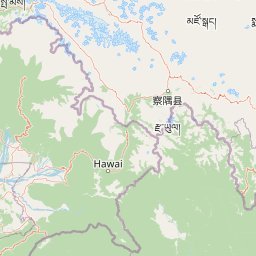
Map view of Namdapha National Park

Use this park location map to pinpoint Namdapha National Park in India, understand its exact geographic position, and read its mapped placement within the surrounding landscape more clearly.

Pigeon | © OpenStreetMap contributors

Location context for Namdapha National Park

Arunachal PradeshChanglang
Park atlas

Compare regional protected landscapes and map the park geography surrounding Namdapha National Park.

Discover Related National Parks Near Namdapha National Park and Surrounding Protected Areas
Continue your exploration from Namdapha National Park by browsing other national parks and protected areas across the diverse Eastern Himalayan region. This focused geographic view allows for direct comparison of conservation landscapes, understanding regional ecological connections, and identifying adjacent wilderness zones.
National parkAssam

Dehing Patkai National Park: Assam's Extensive Lowland Tropical Rainforest Atlas

Explore mapped boundaries and critical primate habitat.

Dehing Patkai National Park is a vital protected area in Assam, renowned as India's largest contiguous lowland rainforest. This park provides a crucial habitat for diverse species, notably featuring seven primate species including the Hoolock gibbon, and serves as a key elephant reserve. Explore the mapped geography of this unique four-layered tropical forest ecosystem, understanding its ecological significance and protected landscape identity within northeastern India.

Area
231.65 km²
Established
2004
IUCN
II
Relief
Lowland
Illustration of a landscape with green mountains, a river, bare trees, and a waterfall under a colorful sky
National parkAssam

Dibru-Saikhowa National Park: Mapped Protected Landscape and Regional Geography

Explore Assam's protected natural terrain and park boundaries.

Dibru-Saikhowa National Park represents a key protected area, providing valuable insight into the natural geography and landscape context of Assam. As a designated national park, its mapped boundaries and distinct regional setting are crucial for understanding the distribution of conservation lands in northeastern India. Explore the geographic specifics and atlas relevance of Dibru-Saikhowa National Park for a structured view of this protected landscape.

Area
350 km²
Established
1999
IUCN
II
Relief
Lowland
National parkKachin State

Hkakaborazi National Park: National Park Protected Landscape and Map Explorer

Explore its mapped boundaries and regional geography in Kachin State.

Hkakaborazi National Park serves as a critical protected area within Kachin State, offering a unique geographic profile for atlas and map exploration. This dedicated entry focuses on its identity as a national park, detailing its mapped landscape context and its role within the broader protected areas network. Understand the specific geographic features and boundaries that define this important natural landscape, essential for any detailed cartographic or regional study.

Area
3,810 km²
Established
1998
IUCN
II
Relief
Mountain
National parkArunachal Pradesh

Mouling National Park: Explore Arunachal Pradesh National Park Geography and Protected Landscape

Mapped protected areas and regional geographic context.

Mouling National Park in Arunachal Pradesh offers a unique opportunity to explore the mapped boundaries and geographic characteristics of a significant protected landscape. This page provides structured insights into its role as a national park, detailing its regional setting and contributing to a broader atlas of protected areas. Understand the distinct natural terrain and landscape context that define this protected area within India.

Area
483 km²
Established
1986
IUCN
II
Relief
Mountain
Watercolor painting of green hills, fields, and a body of water
National parkAssam

Kaziranga National Park National Park: Protected Landscape and Geographic Atlas

Mapped boundaries and regional landscape context for this Assam natural area.

Delve into the detailed geographic profile of Kaziranga National Park, a prominent National Park located in Assam, India. This section focuses on its mapped protected area extent, its unique landscape characteristics within the Brahmaputra valley, and its role as a key natural landmark in northeastern India's atlas. Understand the structured geographic data and protected land identity that makes Kaziranga National Park a distinct entity for exploration.

Area
1,090 km²
Established
1905
IUCN
II
Relief
Lowland
National parkSonitpur

Nameri National Park: A Protected Landscape within Sonitpur's Geography

Explore the mapped terrain and national park boundaries.

Nameri National Park represents a significant protected natural area, contributing to the regional geography of Sonitpur, India. This page offers an atlas-oriented perspective, detailing the park's mapped landscape and its designation as a national park. Understand the geographic context and the protected land's specific identity within this mapped region.

Area
200 km²
Established
1978
IUCN
II
Relief
Mountain
National parkAssam

Orang National Park: Assam's Key Floodplain Protected Landscape

Explore mapped boundaries and terrain context of this national park.

Orang National Park, located in Assam, India, is a significant protected area celebrated for its unique alluvial floodplain terrain and critical role in conservation. This national park provides a focused atlas-style view of grassland and wetland ecosystems, essential habitats for iconic species like the great Indian one-horned rhinoceros and Bengal tiger. Its geographical setting along the Brahmaputra River contributes to a dynamic landscape, offering rich context for understanding protected area distribution and regional natural features. Discover the mapped boundaries and ecological significance of this important protected land.

Area
78.81 km²
Established
1985
IUCN
II
Relief
Lowland
National parkManipur

Shirui National Park: Detailed Protected Landscape and Regional Geography in Manipur

Mapped boundaries and atlas context for this national park.

Shirui National Park serves as a vital protected area within the state of Manipur, offering a unique focal point for geographic exploration. This profile details its identity as a national park, emphasizing its mapped boundaries and landscape context. For users interested in atlas-based discovery and understanding the distribution of protected lands, Shirui National Park provides critical data on regional geography and conservation. Examine its position within India's natural terrain and protected area network.

Area
41.3 km²
Established
1982
IUCN
II
Relief
Mountain

Common questions about visiting, size, designation, and location context for Namdapha National Park

Namdapha National Park FAQs for park facts, access, geography, and protected area context
Find quick answers about Namdapha National Park, including protected-area facts, park geography, trail and visitor context, and how the park fits into its surrounding country and regional landscape.
MoriAtlas Explorer

Continue Your Protected Areas Search Across the Global Atlas

Deepen your exploration by continuing the structured search for national parks and protected areas worldwide. Utilize the comprehensive filtering capabilities to compare different conservation landscapes and refine your understanding of global park geography. Discover more about the distribution and characteristics of protected natural areas.

Global natural geography
