
Mori Atlas logo
Protected landscapeNaturpark Märkische Schweiz

Explore the geographic terrain and protected basin features of this Brandenburg nature park.

Naturpark Märkische Schweiz: A Protected Landscape of Glacial Moraines and River Valleys

Naturpark Märkische Schweiz represents a compact, Ice Age-shaped territory within the German state of Brandenburg. The park features a complex network of terminal moraines, kettle lakes, and the ecologically significant Stobber river valley. This protected landscape preserves a rare hydrological watershed, where headwaters link toward both the Elbe and Oder systems, creating a unique mosaic of forests, wetlands, and small-scale glacial landforms.

nature parkBrandenburgglacial landscapeIce Age morainesmixed forestlakes
A flat-style digital illustration showing a tiered waterfall cascading down a canyon into a winding river that leads to a foreground wetland area with reeds and lily pads under a pinkish sky.

Naturpark Märkische Schweiz

Protected landscape

Park overview

Structured park overview, official facts, and landscape profile for Naturpark Märkische Schweiz

Naturpark Märkische Schweiz park facts, protected area profile, and essential visitor context

Review the core facts for Naturpark Märkische Schweiz, including designation, size, terrain, visitor scale, habitats, and operating context in one park-focused overview.

About Naturpark Märkische Schweiz

Naturpark Märkische Schweiz occupies a distinctive position within Brandenburg's protected-area network as the smallest of the state's large protected areas, yet one with remarkable landscape diversity packed into a relatively compact footprint. Located about 60 kilometers east of Berlin in the Landkreis Märkisch-Oderland, the park surrounds the town of Buckow, which serves as its cultural and administrative center and houses the park's visitor center in the Schweizer Haus.

The park's defining character comes from its glacial origins. The terminal moraines of the last Ice Age shape the rolling ground, with the Krugberg rising to 129 meters as the highest point in the park. After the ice retreated, meltwater carved shallow valleys, formed lakes such as the central Schermützelsee, and left behind bogs and small kettle ponds known as Sölle. The Stobber, the park's most important stream, originates in the Rotes Luch lowland bog near the North Sea-Baltic Sea watershed in a feature described as a pseudobifurcation, before flowing through Buckow and onward toward the Oderbruch and eventually the Baltic Sea.

Ecologically, the park has unusually strong formal protection for its size. The entire terrain is classified as a landscape protection area, while six nature reserves, totaling about 19 square kilometers, lie within the park boundaries. The flagship Stobbertal nature reserve runs alongside the Stobber for roughly 13 kilometers and is also designated under the European Union Habitats Directive, partly because of the presence of the small freshwater mussel (Kleine Flussmuschel). About 87 percent of the park area is recognized as a European bird protection area, and additional Habitats Directive sites are scattered across the region. The common clubtail dragonfly serves as the park's heraldic species, reflecting the importance of clean streams and standing water habitats.

Culturally, the park is closely tied to a tradition of literary and artistic visitation. Wanderers and writers such as Theodor Fontane and Bertolt Brecht were drawn here, and a popular trail known as the Poetenstieg leads from Buckow through mixed forests and the Silberkehle gorge in their footsteps. The Brecht-Weigel-Haus in Buckow commemorates the artist couple, while nearby the former Cistercian convent at Altfriedland, with its fieldstone church and monastery lake, provides a significant medieval counterpoint to the natural setting. A fieldstone architecture route, opened in 2012, links the region's distinctive building heritage with its underlying geology. Together, these qualities give Märkische Schweiz a quiet identity that blends glacially carved scenery, layered conservation designations, and a long-standing cultural landscape.

Quick facts and research context for Naturpark Märkische Schweiz

Naturpark Märkische Schweiz is located in the Landkreis Märkisch-Oderland in eastern Brandenburg, roughly 60 kilometers east of Berlin. It was established on 1 October 1990 as part of the GDR National Park Programme, making it the oldest nature park in Brandenburg. The park covers approximately 205 square kilometers and is administered by the state of Brandenburg, with Buckow as its principal town. The territory is fully designated as a landscape protection area, contains several nature reserves, and overlaps with multiple European habitat and bird protection sites.

Protection and recognition

Terrestrial protected area geography and formal designation records

Naturpark Märkische Schweiz Protection Status and Conservation Records

Naturpark Märkische Schweiz maintains a documented terrestrial protection scope within regional conservation frameworks. Official records assemble management classifications and designation details for environmental analysis.

Protection details

Protection scope
Terrestrial
Transboundary protection
No
Park context

Deeper park guide and search-rich context for Naturpark Märkische Schweiz

Naturpark Märkische Schweiz history, landscape, wildlife, and travel context

Explore Naturpark Märkische Schweiz through its history, landscape character, ecosystems, wildlife, conservation priorities, cultural context, and seasonal travel timing in a structured park guide built for atlas discovery and search intent.

Why Naturpark Märkische Schweiz stands out

The park is best known for its compact, Ice Age-shaped terrain of low moraine ridges, kettle lakes, bogs, and the central Schermützelsee, framed by the mixed forests and small valleys of the Stobber river system. It is also recognized for the unusual hydrological feature of the Stobber, which begins near the North Sea-Baltic Sea watershed and carries its water eventually toward the Oder and the Baltic. The park's emblematic species is the common clubtail dragonfly (Gemeine Keiljungfer).
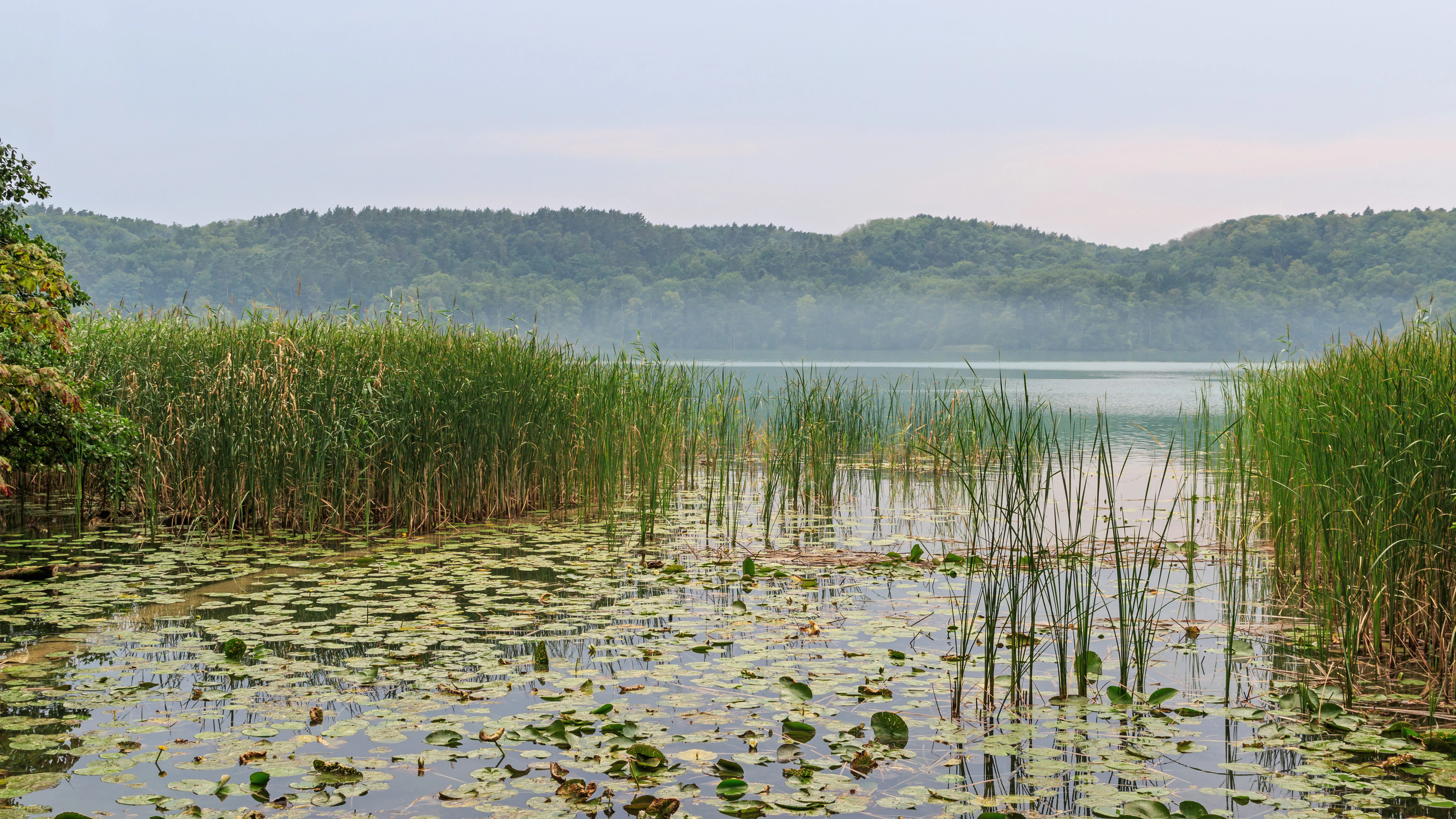
A calm lake view surrounded by reeds, water lilies, and low forested hills under a soft overcast sky.
Schermützelsee lake in Naturpark Märkische Schweiz, featuring a marshy shoreline with reeds and water lilies.

Naturpark Märkische Schweiz history and protected-area timeline

Naturpark Märkische Schweiz was designated on 1 October 1990 through an ordinance that fixed nature reserves and a central landscape protection area as the Naturpark Märkische Schweiz, making it the first nature park established in Brandenburg. The park's creation came within the framework of the National Park Programme of the German Democratic Republic, and the legal text took effect at the moment of German reunification, when responsibility for protected areas shifted to the newly reconstituted state of Brandenburg. The park has been administered by the state of Brandenburg since its inception, with its operational offices located in Buckow.

Over time, additional European-level designations were layered onto the existing park structure. The Stobbertal, the park's central nature reserve running alongside the Stobber river, was recognized as a Fauna-Flora-Habitat area under the European Union Habitats Directive, in part because of the protected small freshwater mussel found there. Large portions of the park, around 87 percent, were designated as a European bird protection area, including the Altfriedländer Teich- und Seengebiet in the northeastern part of the park. A dedicated Fledermaus-Museum Julianenhof was later added within the park boundaries to communicate the importance of bat conservation, while the cultural heritage of the area has been interpreted through facilities such as the Brecht-Weigel-Haus in Buckow and the Oberbarnimer Feldsteinroute, a fieldstone architecture trail opened in 2012.

Naturpark Märkische Schweiz landscape and geographic character

The Märkische Schweiz landscape is a textbook expression of the recent Ice Age. The gentle relief of the park is shaped by terminal moraines, with the Krugberg at 129 meters forming the highest elevation in the area. After the ice sheet withdrew, meltwater cut shallow channels into the new land surface and pooled in basins that became lakes, while the remaining depressions filled to form bogs, fens, and the small kettle ponds locally called Sölle.

The single most prominent feature of the park is the Schermützelsee, located near the center of the protected area and closely associated with the town of Buckow. The Stobber river, flowing through Buckow and onward toward the Oderbruch, is the park's central watercourse and runs through wooded valleys for much of its length. Its source area, the Rotes Luch, is a lowland mire situated very near the divide between North Sea and Baltic drainage. This location is geomorphologically unusual: the Stobber's headwaters sit on the watershed and, through a pseudobifurcation, link to both the Elbe and Oder systems. From Rotes Luch the 25-kilometer Stobber travels through Buckow and ultimately joins the Friedländer Strom, whose water reaches the old Oder, the Hohensaaten-Friedrichsthaler Wasserstraße, and finally the Stettiner Haff on the Baltic.

The terrain as a whole is composed of mixed forest, small agricultural openings, lake margins, and the narrow river valleys of the Stobber and its tributaries. Trails, including the Poetenstieg from Buckow, thread through this landscape, passing the Silberkehle, a wooded gorge whose steep slopes and mixed forest give visitors one of the park's most scenic walking experiences.

Naturpark Märkische Schweiz ecosystems, habitats, and plant life

The park's ecological identity is built around a tight integration of glacial landforms, surface water, and forest, all impressed on a relatively small area. Roughly speaking, the park's surface is a mosaic of agricultural land, woodland, and water: about 49 percent is used for agriculture, around 39 percent is forested, and water surfaces account for nearly 4 percent. Within this framework, large parts of the park are formally protected at landscape, national, and European levels.

The Stobbertal nature reserve, at 884 hectares and stretching about 13 kilometers along the Stobber, anchors the park's ecological core. It is the area's most important corridor for clean, flowing freshwater habitats, which support sensitive species such as the small freshwater mussel and a wide range of invertebrate life. The common clubtail dragonfly, established as the park's emblematic species, signals the conservation value placed on these well-vegetated streams and lake margins. Bog and mire habitats, particularly in the Rotes Luch area, complement the river and lake systems, while mixed forests, including beech and other broadleaf types along with conifers, cover much of the higher ground and slopes.

At the European level, the park carries significant recognition. All of the territory is a landscape protection area, while six nature reserves totaling about 19 square kilometers host stricter protection. Roughly 87 percent of the park is also listed as a European bird protection area, and an additional 14 Fauna-Flora-Habitat sites have been designated within the park's boundaries, reinforcing its status as a densely protected ecological landscape in eastern Brandenburg.

Naturpark Märkische Schweiz wildlife and species highlights

Wildlife in the Märkische Schweiz reflects the variety of habitats packed into this relatively small park: clean running water, lakes, boggy ground, mixed woodland, and open farmland. Among the most prominent protected species is the small freshwater mussel (Kleine Flussmuschel), which is specifically cited as a reason the Stobbertal is designated under the European Union Habitats Directive. The presence of this mussel, along with other aquatic invertebrates, points to the relatively undisturbed quality of the Stobber and its tributaries.

The park's heraldic species, the common clubtail dragonfly (Gemeine Keiljungfer), is associated with the clean streams and well-vegetated shorelines of the area. The conservation focus on dragonflies, as well as on the bat populations highlighted by the Fledermaus-Museum Julianenhof, indicates that the park places particular value on species tied to specific microhabitats rather than to large mammal fauna. Birds are a major part of the park's ecological identity, with about 87 percent of the area designated as a European bird protection area. The northeastern lake district around the Altfriedländer Teich- und Seengebiet, including the Kietzer See, supports aquatic and wetland bird communities typical of the broader Oderbruch region. Mixed forests across the park also host typical central European woodland species, while the open agricultural areas sustain species adapted to farmland and field margin habitats.

Naturpark Märkische Schweiz conservation status and protection priorities

Naturpark Märkische Schweiz stands out for the unusual density of conservation designations layered onto a relatively small area, reflecting its ecological importance within Brandenburg. The entire park is formally designated as a landscape protection area, providing the broad base layer of landscape-level protection. Within that framework, six nature reserves, covering roughly 19 square kilometers (about 9 percent of the park), offer stricter habitat-level protection, with the Stobbertal as the flagship reserve following the Stobber river for about 13 kilometers.

The Stobbertal reserve carries additional European significance: it is designated as a Fauna-Flora-Habitat area under the European Union Habitats Directive, a status partly driven by the conservation needs of the small freshwater mussel. Furthermore, about 87 percent of the park's area is recognized as a European bird protection area (SPA), encompassing diverse bird communities in forests, wetlands, agricultural land, and the lake districts around Altfriedland. Fourteen additional Fauna-Flora-Habitat sites are spread across the park, reinforcing its importance as a stepping stone in the broader network of protected areas across eastern Brandenburg and the Oder region.

Beyond statutory protection, the park invests in interpretation and outreach. The Fledermaus-Museum Julianenhof is dedicated to bat conservation and raises awareness of how to protect bats and their habitats, while the common clubtail dragonfly is used as the park's emblem to communicate the value of healthy freshwater ecosystems. Together, these elements reflect a conservation approach that combines legal protection across multiple jurisdictional levels with public engagement and education.

Naturpark Märkische Schweiz cultural meaning and human context

The cultural texture of the Märkische Schweiz is closely bound up with its landscape, shaped both by medieval monastic life and by literary and artistic visitation of more recent centuries. The Cistercian convent at Altfriedland, founded in the Middle Ages and now represented by its monastery church and remaining buildings beside the Klostersee, is one of the most architecturally significant medieval monastery sites in the Barnim and Oderbruch region, comparable in regional importance to the better-known monastery complex at Chorin. The prevalence of fieldstone as a traditional building material across the area is celebrated through the Oberbarnimer Feldsteinroute, opened in 2012, which traces the area's building heritage as a thread of cultural and geological history.

Buckow, the park's central town, has long been a destination for writers and thinkers. Figures associated with the town include Theodor Fontane and Bertolt Brecht, and the Brecht-Weigel-Haus in Buckow preserves the memory and creative life of Brecht and his wife, the actress Helene Weigel. The Poetenstieg, a popular hiking trail leading from Buckow through mixed forest and the Silberkehle gorge, explicitly invokes this literary lineage. Together, these cultural elements give the park a strong sense of place rooted in both natural and human history.

Top sights and standout views in Naturpark Märkische Schweiz

Among the strongest distinguishing features of the Märkische Schweiz is its compact glacial landscape, where low moraine ridges, the Schermützelsee, and the Stobber river valley form a closely interlocked scenic system within a relatively small area. The Stobber's origin near the North Sea-Baltic watershed, with a pseudobifurcation at Rotes Luch, gives the park a hydrological curiosity that stands out even within the wider context of northern German glaciation.

Equally distinctive is the layered conservation framework: a landscape protection area covering 100 percent of the park, multiple nature reserves, and extensive overlap with European Union Habitats Directive sites and bird protection areas. Compounding this is a cultural heritage that ranges from medieval Cistercian architecture and fieldstone building traditions to a literary tradition anchored in Buckow and the Brecht-Weigel-Haus, making the park a place where ecological and cultural landscapes meet within easy reach of Berlin.

Best time to visit Naturpark Märkische Schweiz

Across the year, the Märkische Schweiz shifts character with the seasons in ways typical of north German Ice Age countryside. Late spring and early summer are particularly attractive for experiencing the park's dragonflies, blooming mixed forest understory, and the full water levels of streams and lakes, while autumn brings rich color to the beech and oak dominated forests and atmospheric light across the Schermützelsee. Winter visits offer a quieter experience of the park's ridges, bogs, and frozen lake margins, with frost and occasional snow accentuating the glacial relief. In warmer months, the Buckower Kleinbahn operates as a heritage railway on weekends between Müncheberg and Buckow, adding a layer of cultural mobility to visits during this period.

Monthly climate preview

Long-term temperature ranges and precipitation rhythm across the park coordinate

Naturpark Märkische Schweiz Climate Normals and Monthly Weather Patterns

Naturpark Märkische Schweiz records measured monthly temperature values spanning from sub-zero winter minimums to warm summer maximums alongside steady daily precipitation averages. Reviewing the complete twelve-month climate profile provides a clearer picture of long-term environmental conditions at the representative coordinate.
Annual mean9 °C
-1 °C20 °C
Jan-1°
Feb
Mar
Apr
May14°
Jun18°
Jul20°
Aug20°
Sep15°
Oct
Nov
Dec
Warmest month
July

20.3 °C

Coolest month
January

-1.1 °C

Wettest month
July

2.5 mm/day

Driest month
April

1.1 mm/day

Park location guide

Geography guide, regional context, and park location map for Naturpark Märkische Schweiz

Naturpark Märkische Schweiz park geography, regions, and map view in Germany

Understand where Naturpark Märkische Schweiz sits in Germany through a broader geographic reading of the surrounding landscape, nearby location context, and its mapped position within the national park landscape.

How Naturpark Märkische Schweiz fits into Germany

Germany is a federal republic in Western and Central Europe with a population of over 83 million across sixteen constituent states. It is Europe's largest economy by nominal GDP and a major global exporter and importer. The capital is Berlin, and the country borders Denmark, Poland, Czech Republic, Austria, Switzerland, France, Luxembourg, Belgium, and the Netherlands.

Wider geography shaping Naturpark Märkische Schweiz in Germany

Germany is located in Western and Central Europe, spanning 357,022 km². It borders Denmark to the north, Poland and the Czech Republic to the east, Austria and Switzerland to the south, and France, Luxembourg, Belgium, and the Netherlands to the west. The country has coastlines on the Baltic Sea and North Sea to the north, with the Alps located in the southern region.

Map view of Naturpark Märkische Schweiz

Use this park location map to pinpoint Naturpark Märkische Schweiz in Germany, understand its exact geographic position, and read its mapped placement within the surrounding landscape more clearly.

Pigeon | © OpenStreetMap contributors

Location context for Naturpark Märkische Schweiz

Brandenburg

Visual reference for terminal moraines, kettle lakes, and protected woodland habitats

Naturpark Märkische Schweiz Photos and Glacial Landscape Scenery

Visual records capture the distinctive Ice Age terrain, terminal moraines, and winding river valleys defining Naturpark Märkische Schweiz. Photographic documentation reveals the underlying protected habitats, kettle lakes, and dense mixed forests shaping the regional ecosystem.

A calm lake view surrounded by reeds, water lilies, and low forested hills under a soft overcast sky.

A group of brown horses grazing in a bright green pasture on a sunny day.

Park atlas

Compare regional park geography and connected natural terrain across Brandenburg

Other Parks Near Naturpark Märkische Schweiz and Surrounding Protected Landscapes

Continuing from Naturpark Märkische Schweiz leads directly into neighboring protected areas and regional glacial landscapes. Expanding the geographic comparison reveals broader ecological patterns across the wider Brandenburg territory.
Nature reserveBrandenburg
About 0 km away#1 closest

East

Stobbertal Nature Reserve: Geography, Mapped Boundaries, and Protected Landscape Context

A detailed geographic study of the Stöbber river valley in Brandenburg, Germany

Stobbertal represents a compact yet ecologically dense protected area in Brandenburg. This study provides access to information regarding its diverse forest and wetland habitats, ranging from ancient oak-hornbeam woodlands to rare floodplain remnants. Gain insight into the regional importance of the river corridor, its hydrologic features, and the protected species that inhabit this distinct northeastern German landscape.

Area
8.84 km²
Established
1990
IUCN
IV
A horizontal watercolor painting showing layers of soft-toned hills in green and purple, with tall blades of grass in the foreground.
Nature reserveBrandenburg
About 2 km away#2 closest

Southeast

Klobichsee Nature Reserve: Protected Landscape and Glacial Lake Geography in Brandenburg

Mapping aquatic ecosystems and protected boundaries in eastern Germany

Klobichsee Nature Reserve covers roughly 5.59 square kilometers, centering on the Großer Klobichsee and Kleiner Klobichsee glacial lakes. This protected area in Brandenburg preserves essential forest and wetland habitats, maintaining the ecological character of the region situated between Buckow and Münchehofe.

Area
5.59 km²
Established
1990
IUCN
IV
Climate
Temperate
Watercolor painting of a tranquil, flat wetland landscape with pale green, pink, and yellow hues representing water, vegetation, and a soft sky.
Nature reserveBrandenburg
About 9.8 km away#3 closest

Northeast

Europäisches Vogelschutzgebiet Altfriedländer Teich- und Seengebiet: Protected Area Geography

Nature reserve wetland network in eastern Brandenburg

Discover the geographic structure of this extensive pond and lake complex in Märkisch-Oderland. This protected area features shallow open water, sprawling reedbeds, and remnants of lowland peat that support dense populations of migratory waterfowl and rare breeding waterbirds within a working cultural landscape.

Area
7 km²
Relief
Lowland
Climate
Temperate
Scope
Terrestrial
A horizontal watercolor painting showing a soft-focus landscape of light green trees, yellow fields, and pale blue rolling hills in the background.
Nature reserveBrandenburg
About 18 km away#4 closest

West

Lange Dammwiesen und Unteres Annatal: Glacial Ridges and Nature Reserve Geography

A mapped protected area in the state of Brandenburg, Germany

Lange Dammwiesen und Unteres Annatal represents a compact but ecologically rich nature reserve featuring signature osar ridges and varied meadow habitats. This site provides valuable insight into the glacial landscape of the North German Plain, illustrating the effectiveness of conservation grazing in maintaining diverse ecosystems within the Brandenburg region.

Area
0.013 km²
Established
1990
IUCN
IV
Relief
Lowland
A horizontal watercolor illustration showing soft, pastel-colored rolling hills and a calm lake or pond in the foreground, surrounded by grassy banks.
Nature reserveBrandenburg
About 23 km away#5 closest

South

Beerenbusch Nature Reserve: Geographic Profile and Protected Woodland Landscapes of Brandenburg

Mapping forest boundaries in the German lowlands

Located in the Oder-Spree district, Beerenbusch protects rare oak-hornbeam and alder swamp forest ecosystems. This profile details the reserve landscape, cultural landmarks like the Königskiefer, and its importance as a surviving woodland refuge within the Brandenburg forest belt.

Area
0.7 km²
Established
1967
IUCN
IV
Relief
Lowland
Watercolor painting of a green valley with a meandering stream and a cluster of trees against a light background.
Nature reserveBrandenburg
About 26 km away#6 closest

North

Cöthener Fließtal Nature Reserve in Brandenburg: Glacial Geography and Protected Woodland Atlas

Mapping the stream corridors and moraine landscapes of eastern Brandenburg

Cöthener Fließtal is a 75-hectare protected area that bridges the hilly Barnim plateau and the Oderbruch lowlands. The site features a dense concentration of glacial landforms, including end-moraine ridges and spring-fed mires. Visitors can explore the interplay between natural forest ecosystems and the restored elements of a historic nineteenth-century landscape park found along the Cöthener Fließ stream.

Area
0.75 km²
Established
2003
IUCN
IV
Relief
Upland
Protected landscapeWest Pomeranian Voivodeship
About 26 km away#7 closest

North

Cedynia Landscape Park: Mapped Protected Landscapes and Regional Geography in Poland

Protected mosaic of sandy forests and river valleys

Spanning 308 square kilometers, Cedynia Landscape Park protects a complex transition zone in Poland. The area features the expansive Puszcza Piaskowa pine forests, the hilly moraine relief of the Cedynia Carpathians, and the biodiverse wetlands of the lower Oder River. This protected landscape represents an essential study in lowland ecological gradients and postglacial terrain development within the West Pomeranian Voivodeship.

Area
308.5 km²
Established
1993
Relief
Upland
Climate
Temperate
Protected landscapePoland
About 27 km away#8 closest

East

Park Krajobrazowy Ujście Warty: Protected Landscape and River Valley Atlas

Mapping wetland ecosystems and floodplain geography in western Poland

Park Krajobrazowy Ujście Warty preserves a significant lowland river valley landscape characterized by vast open pastures, marshes, and rare riparian oak forests. Located primarily within the Lubuskie region, this protected area offers a clear view into the floodplain processes of the Warta river basin, providing a distinct geographic context for wetland conservation and waterbird habitat mapping in Poland.

Area
194.96 km²
Established
1996
Relief
Lowland
Climate
Temperate

Common questions about visiting, size, designation, and location context for Naturpark Märkische Schweiz

Naturpark Märkische Schweiz FAQs for park facts, access, geography, and protected area context

Find quick answers about Naturpark Märkische Schweiz, including protected-area facts, park geography, trail and visitor context, and how the park fits into its surrounding country and regional landscape.
MoriAtlas Explorer

Continue Your Protected Areas Search Across the Global Atlas

Deepen your exploration by continuing the structured search for national parks and protected areas worldwide. Utilize the comprehensive filtering capabilities to compare different conservation landscapes and refine your understanding of global park geography. Discover more about the distribution and characteristics of protected natural areas.

Global natural geography