
Mori Atlas logo
Protected landscapeNaturpark Nuthe-Nieplitz

Examining the confluence of glacial valleys, riverine wetlands, and rewilded terrain in the heart of Germany.

Naturpark Nuthe-Nieplitz: A Detailed Geographic Atlas of Brandenburg Protected Landscapes

Naturpark Nuthe-Nieplitz encompasses a distinct geographic mosaic southwest of Berlin, defined by the winding paths of the Nuthe and Nieplitz rivers. This protected landscape contains a complex variety of terrain, ranging from pine-forested hill ridges to expansive fens and wet meadows shaped by glacial activity. Through this structured atlas record, investigate the ecological boundaries and the history of conservation efforts that connect the surrounding rural villages with restored wetland habitats.

nature parkBrandenburgglacial valleywetland lowlandnuthe rivernieplitz river
A flat vector illustration of a scenic landscape showing a winding river, a waterfall cascading from a cliff, green hills, pine trees in the foreground, and mountains in the distance under a sunlit sky.

Naturpark Nuthe-Nieplitz

Protected landscape

Park overview

Structured park overview, official facts, and landscape profile for Naturpark Nuthe-Nieplitz

Naturpark Nuthe-Nieplitz park facts, protected area profile, and essential visitor context

Review the core facts for Naturpark Nuthe-Nieplitz, including designation, size, terrain, visitor scale, habitats, and operating context in one park-focused overview.

About Naturpark Nuthe-Nieplitz

Naturpark Nuthe-Nieplitz is a protected landscape in Brandenburg that links rural villages, glacial landforms, pine forest and one of the region's most significant lowland wetland complexes. It was formally opened in August 1999 and was built on a decade of conservation work that began after German reunification, when biologists, foresters and local citizens came together to counter planned development pressures in the Nuthe-Nieplitz valley. The initiative later led to the acquisition of land, the creation of a regional conservation association and the gradual rewilding of former agricultural and military sites.

The physical setting of the park is shaped by the last ice age. The Nuthe-Nieplitz-Niederung acts as a Zwischenurstromtal, a valley between two larger glacial outwash plains, and is bordered on either side by the gently undulating sand plateaus of Zauche to the west and Teltow to the east. Remnants of end moraines break the flatness of the valley, producing modest but locally prominent ranges such as the Glauer Berge and the single Löwendorfer Berg, the highest point in the park at around 103 meters. The two namesake rivers, the Nuthe and the Nieplitz, rise in the northern Fläming and meet near Gröben, where they form a broad, open lowland crossed by slow channels and dotted with shallow lakes.

Centuries of drainage, undertaken to convert the waterlogged valley into useful farmland, left a dense network of canals, polders and pumping stations. Since the 1990s, many of those structures have been removed or switched off, allowing mires to refill, wet meadows to return and new small lakes such as the Schwanensee near Stangenhagen to emerge naturally. The park today balances this ecological restoration with traditional Brandenburg land use, including orchard meadows, sheep grazing on dry grasslands, small-scale forestry and a tourism economy based on quiet walking, cycling, wildlife observation and visits to historic villages and manor houses.

Quick facts and research context for Naturpark Nuthe-Nieplitz

Naturpark Nuthe-Nieplitz sits in Brandenburg, south of Potsdam and southwest of Berlin, between the Fläming, Teltow and Zauche regions. Its approximately 623 square kilometers include six nature reserves and a large landscape protection area, with nature reserves covering roughly one fifth of the surface. The heart of the park is the Nuthe-Nieplitz lowland, formed at the end of the last ice age as a glacial valley between the higher plateaus of Zauche and Teltow. Forests, especially pine, cover the largest share of the land, alongside farmland, meadows and patches of marsh and open water. The park belongs to the network of Brandenburger Naturparks and has been a focal point for rewetting projects, meadow restoration and the reintroduction of lost bird species since the post-reunification period.

Protection and recognition

Documented conservation scope, designation history, and recognized protected area data.

Naturpark Nuthe-Nieplitz Protection Status and Territorial Management Framework

Naturpark Nuthe-Nieplitz maintains a defined terrestrial protection scope within its regional landscape boundary. Systematic records compile documented conservation frameworks, management parameters, and official designation details for this protected area.

Protection details

Protection scope
Terrestrial
Transboundary protection
No
Park context

Deeper park guide and search-rich context for Naturpark Nuthe-Nieplitz

Naturpark Nuthe-Nieplitz history, landscape, wildlife, and travel context

Explore Naturpark Nuthe-Nieplitz through its history, landscape character, ecosystems, wildlife, conservation priorities, cultural context, and seasonal travel timing in a structured park guide built for atlas discovery and search intent.

Why Naturpark Nuthe-Nieplitz stands out

The park is especially known for its extensive wetland mosaic in the Nuthe-Nieplitz lowland, where the two namesake rivers join, and for a succession of conservation projects carried out since the early 1990s. It is distinguished by the rewetting of drained fens, the restoration of species-rich meadows and old orchard landscapes, and the reintroduction of long-absent birds such as the little owl. Large flocks of migrating geese and cranes pass through the meadows each year, and the park is the only place in Germany where a single elk has settled. Its combination of intact marshland, old Märkische villages and rewilded former military land gives it a strong identity among Brandenburg's nature parks.
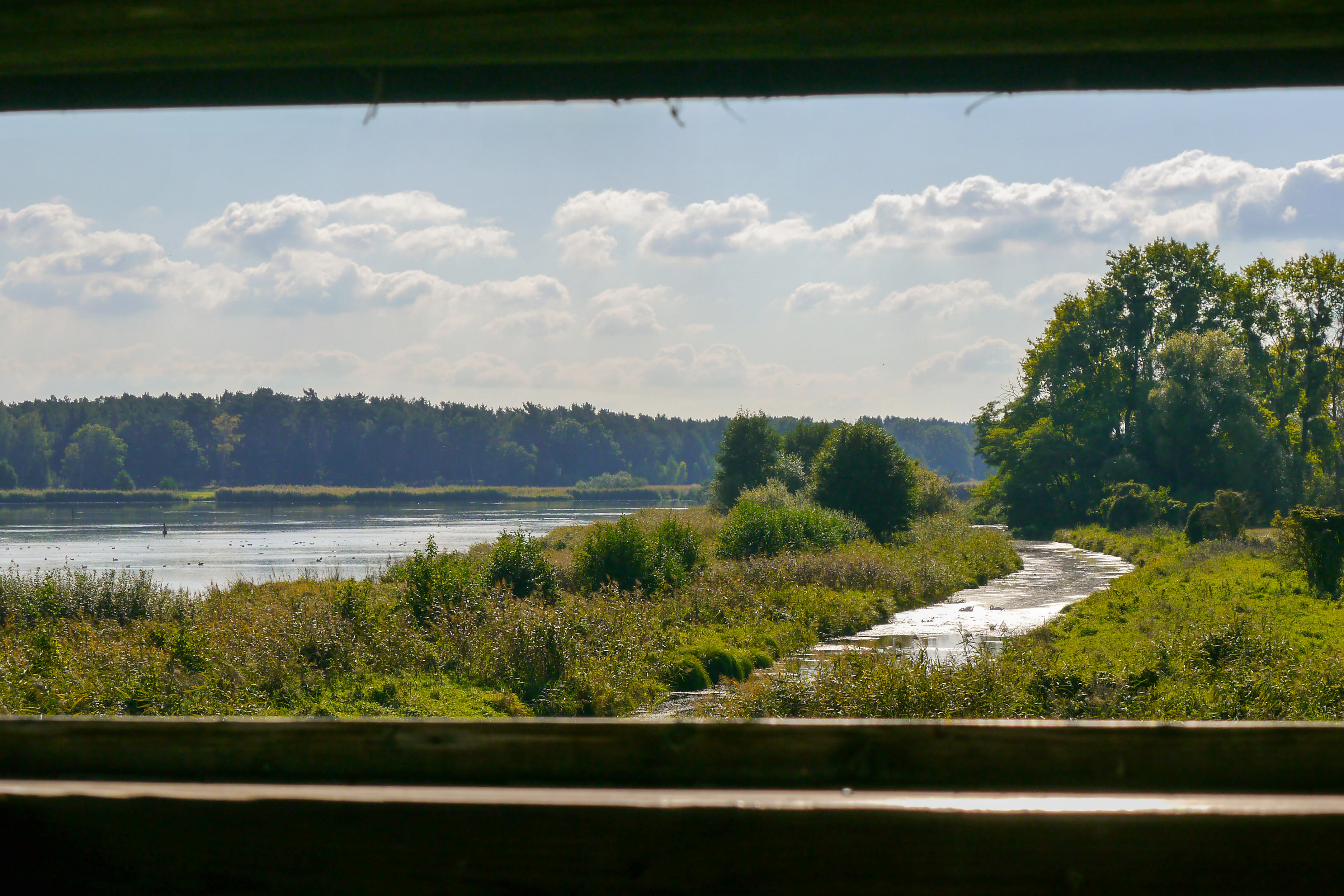
A view through a wooden window frame looking out over a lake and a winding wooden boardwalk through a marshy wetland with trees in the background under a partly cloudy sky.
View of Schwanensee and Pfefferfliess from an observation tower in Naturpark Nuthe-Nieplitz.

Naturpark Nuthe-Nieplitz history and protected-area timeline

The park's history is closely tied to the post-reunification conservation movement in eastern Germany. After 1989, the biologist and wildlife photographer Karl Decruppe and the regional chief forester Manfred Kroop began collaborating to protect the Nuthe-Nieplitz lowland against development pressures. In 1991 they and other supporters founded the Landschafts-Förderverein Nuthe-Nieplitz-Niederung, which over the following years acquired several thousand hectares of farmland, forest and water bodies, removed concrete from former livestock facilities, planted hedges and orchard meadows, and carried out the first biotope surveys of the region.

In 1995 the central Nuthe-Nieplitz-Niederung was formally designated as a nature reserve, initially covering around 5,500 hectares, and the first nature wardens began work on the ground. In 1998 the association purchased large parts of former military training grounds near Jüterbog and Glau, laying the foundation for the Stiftung Naturlandschaften Brandenburg and for the Wildgehege Glauer Tal, which would later become the park's main visitor centre. The nature park itself was officially opened in August 1999, with a launch event held in the park of Schloss Blankensee and on the Nieplitz meadow behind the local farm museum.

Through the 2000s and 2010s the regional association acquired additional lakes, restored the original outflow of the Riebener See, decommissioned pumping stations and rewetted mires including the Saarmunder Elsbruch and parts of the Pfefferfließ. New visitor facilities such as the Glauer Tal visitor centre, observation towers, walking apps and a network of themed trails strengthened public engagement. A reintroduction project for the little owl, which had been absent from the area for more than two decades, achieved lasting success and was recognized under the UN Decade on Biodiversity in 2019, symbolizing the long-term restoration work that defined the park.

Naturpark Nuthe-Nieplitz landscape and geographic character

The landscape of Naturpark Nuthe-Nieplitz is built on the legacy of the last ice age. The central Nuthe-Nieplitz lowland was carved as an intermediate outwash valley between two larger glacial channels, with the Baruther Urstromtal to the south and the Berliner Urstromtal to the north. On either side of this valley, the higher plateaus of Zauche on the west and Teltow on the east rise only gently, formed from glacial gravel, marl and sand deposits. Residues of older end moraines run through the valley as small hill ranges, including the pine-covered Glauer Berge, which stretch roughly four kilometers between the Blankensee and the Nuthe near Kleinbeuthen, and the Löwendorfer Berg, which at around 103 meters is the highest point in the park.

The water system defines the visual identity of the park. The Nuthe and Nieplitz rise in the northern Fläming, flow through the central lowland and join near the historic Gröbener Kietz. Their waters feed a chain of shallow lakes such as the Blankensee, the Riebener See, the Grössinsee, the Schiaßer See and the Gröbener See, most of them reed-fringed and slow-flowing. Smaller streams and brooks, including the meandering Pfefferfließ, thread through wet alder woodlands and reed beds. To the west, the Beelitzer Sander forms a wide, dry, fan-shaped sand plain, the largest pine forest area in the park, while smaller alder swamps known as Elsbrüche, including those at Siethen and Saarmund, fill the wet depressions between the ridges.
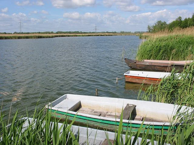
Several small rowboats moored among tall green reeds at the edge of a lake under a cloudy blue sky.
Small rowboats moored along the reedy bank of Schiaßer See.

Naturpark Nuthe-Nieplitz ecosystems, habitats, and plant life

Ecologically, the park is defined by the contrast between dry sandy uplands and wet lowland valleys. The pine forests of the Beelitzer Sander and the hill ridges grow on poor, acidic sand soils, while the central Nuthe-Nieplitz valley is dominated by wet meadows, fens, marshland, reed beds, alder swamp woodland and slow-moving brooks. Several distinct forest communities are present, including the rare pedunculate oak and hornbeam forests still surviving along the upper Pfefferfließ, the dense and almost primeval alder swamp forest in the Zarth reserve east of Treuenbrietzen, and the open pine woodland of the former military training grounds at Forst Zinna, where more than six hundred ferns and flowering plants have been recorded.

Mires and wet meadows are central to the park's ecological identity. Restoration has brought back swamp-sedge communities along the Pfefferfließ, fenland around the Rauhes Luch near Liebätz, and wet meadow gradients around Stücken, Körzin and Dobbrikow. Dry habitats also have an important place, including inland dune vegetation at the nine-hectare Wanderdüne within Forst Zinna, inland salt margins supported by an EU LIFE project, and orchid-rich wet woodland in the Zarth reserve, where five species of orchid have been documented alongside around 340 plant species overall.
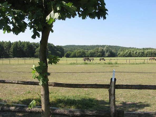
A landscape view featuring a tree and wooden fence in the foreground, a grassy pasture with grazing horses in the midground, and a forested hill in the background under a clear blue sky.
View of the eastern foothills of the Glauer Berge hills near Mietgendorf, with horses grazing in a pasture.

Naturpark Nuthe-Nieplitz wildlife and species highlights

The park is widely recognized as one of Brandenburg's most important bird areas. The Nuthe-Nieplitz valley, the central Rieselfelder around the reunited lakes and the wet meadows of the Pfefferfließ together host breeding and migrating populations of lapwing, ortolan bunting, red and black kite, marsh harrier, osprey, white-tailed eagle, common buzzard, northern goshawk, sparrowhawk, hobby and kestrel. White storks nest in nearly every village and a small number of rare black storks use the dense forest of the Zarth. Each spring and autumn, the meadows serve as a roosting and resting area for tens of thousands of migratory geese, particularly bean geese and the occasional white-fronted goose, and the park's observation towers, including those at Blankensee and Stangenhagen, are well known for crane and waterfowl viewing. The crane, with its characteristic silhouette, also gives the park its logo.

Larger mammals are present in smaller numbers typical of mixed-use rural landscapes. Roe deer and red deer are widespread across the forests and meadows, fallow deer are kept in the Wildgehege Glauer Tal, and small groups of European mouflon, descended from former military stocks, still live on the old training grounds. Wolves pass through the area regularly, and the park is notable for hosting the only individual moose that has settled in Germany, a notable exception that has drawn considerable attention. The park has also become an important site for the reintroduction of the little owl, which had disappeared from the region for over a quarter of a century before its return through a long-running conservation breeding and release programme.
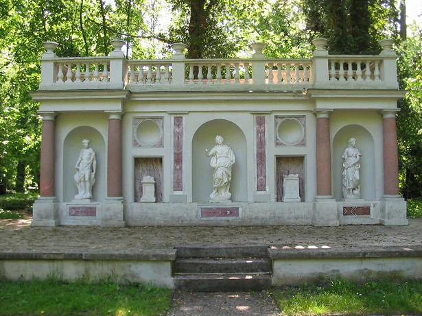
A classical style stone wall with three arched niches containing white statues, pink columns, and a top balustrade, situated in a green park with trees in the background and steps leading up to it.
Classical garden wall featuring three arched niches with white statues, topped by a balustrade, set within a wooded park.

Naturpark Nuthe-Nieplitz conservation status and protection priorities

Conservation is at the very heart of the park's identity. Around one fifth of its total area lies within six formal nature reserves, including the central Nuthe-Nieplitz-Niederung, the Pfefferfließ, the Zarth, Forst Zinna Jüterbog-Keilberg, Rauhes Luch and Bärluch. A further large share is covered by the Landschaftsschutzgebiet Nuthetal-Beelitzer Sander, while parts of the Nuthe-Nieplitz-Niederung are also protected as a European bird protection area under the EU Birds Directive. The Zarth reserve has been identified for inclusion in the Natura 2000 network, linking the park into the broader European ecological network.

The conservation approach is unusually active. Since the early 1990s, more than 3,500 hectares of land have been brought under nature-friendly management, around five hundred hectares of former farmland and mires have been rewetted, more than fifty thousand tons of concrete from old agricultural and military facilities have been removed, and kilometres of hedges and orchard meadows have been replanted. Former military training grounds at Glau and near Jüterbog, excluded from public use for decades, have been deliberately left to develop into rare biotopes of high botanical value. Restoration measures for inland salt habitats were supported by an EU LIFE project, and the long-term reintroduction of the little owl was recognized under the UN Decade on Biodiversity, reflecting an approach that combines habitat restoration, species recovery and public engagement.

Naturpark Nuthe-Nieplitz cultural meaning and human context

The cultural landscape of the park reflects the long rural and aristocratic history of the Mark Brandenburg. Many small villages preserve the typical Märkisches Mittelflurhaus, a half-timbered farmhouse whose barn is set against the gable of the residential wing, including the restored Spiekerhus in Kemnitz, which serves as a regional example of this building type. Manor houses and estates such as Schloss Blankensee, once owned by the dramatist Hermann Sudermann, retain landscaped parks with small classical temples, statues and ornamental bridges crossed by branches of the Nieplitz.

The region has a strong literary and historical resonance. Theodor Fontane travelled through the area and used local church and village records, including the unusually old parish register of Gröben dating from 1575, in his Wanderungen durch die Mark Brandenburg. Historic town centres at Jüterbog, Luckenwalde, Beelitz and Treuenbrietzen, the medieval monastic complex of Kloster Zinna and the early twentieth-century Beelitz-Heilstätten sanatorium all sit within easy reach of the park. Local festivals, including the asparagus festival in Beelitz, the Sabinchenfest in Treuenbrietzen, the museum festival in Blankensee and the annual NaturParkFest in Glau, reflect a strong regional cultural identity that has been carefully woven into the park's tourism offer.
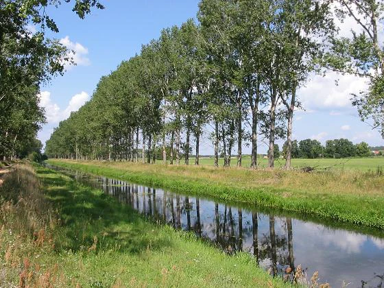
A narrow river reflecting a line of tall trees under a blue sky with grassy banks.
The Nieplitz river near Zauchwitz, featuring a row of trees reflecting in the calm water.

Top sights and standout views in Naturpark Nuthe-Nieplitz

Highlights of the park are spread across a rich mosaic of nature, history and small-scale village culture. The central Nuthe-Nieplitz lowland at the confluence of the rivers is the most characteristic landscape, with its wide wet meadows, reed-bordered lakes and observation towers. The forest reserves of the Zarth and Forst Zinna Jüterbog-Keilberg add ecological depth, the latter containing one of Germany's few inland wandering dunes and an undeveloped former military landscape of remarkable botanical diversity. The rewetted fens of the Pfefferfließ and the small, specialized Zwischenmoor at Rauhes Luch show how drainage and restoration can reverse over time.

Cultural anchors include Schloss Blankensee with its literary connection to Hermann Sudermann, the half-timbered Spiekerhus in Kemnitz, the historic villages of Stangenhagen, Gröben and Dobbrikow, and the visitor centres at Glauer Tal and Stücken. A well-developed network of walking, cycling and Nordic walking routes, supported by themed trails such as the Ortolan circular route and the Fläming-Walk, makes the park unusually accessible for slow exploration of the Brandenburg countryside.
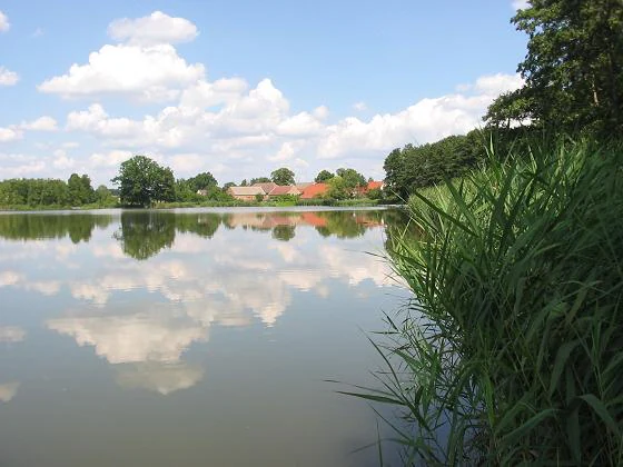
A calm lake with tall green reeds in the foreground on the right, reflecting white clouds and blue sky on its surface, with trees and red-roofed buildings visible on the far shore.
Bauernsee lake in Dobbrikow, Brandenburg, with tall reeds along the shore and village buildings reflected in the calm water under a blue sky.

Best time to visit Naturpark Nuthe-Nieplitz

The park is most atmospheric in spring, when rising water levels and returning warmth bring fresh colour to the meadows, woodland and orchards, and when migratory birds begin to arrive in numbers. Late summer and early autumn offer the richest wildlife moments, with cranes and large flocks of geese gathering and resting on the wet meadows, especially around the observation towers at Blankensee and Stangenhagen. Winter can bring a particular stillness, with frost on the meadows, druzy ice along the lake edges and a quieter atmosphere for walking and cycling, while the inland dunes and dry pine forests retain their character year-round. A visit at any of these seasons will show a different side of the same landscape, since the park shifts between wetland, woodland and rural village scenery as the year turns.

Monthly climate preview

Long-term representative temperature and precipitation patterns across the year

Naturpark Nuthe-Nieplitz Climate Normals and Annual Weather Rhythm

Naturpark Nuthe-Nieplitz tracks measured long-term temperature swings from sub-zero winter minimums to warm summer maximums alongside steady daily precipitation values. Reviewing the complete monthly climate dataset provides structured context on temperature normals and precipitation variation across the protected landscape.
Annual mean10 °C
-1 °C20 °C
Jan-1°
Feb
Mar
Apr
May14°
Jun18°
Jul20°
Aug20°
Sep15°
Oct
Nov
Dec
Warmest month
July

20.3 °C

Coolest month
January

-0.7 °C

Wettest month
July

2.4 mm/day

Driest month
April

1.1 mm/day

Park location guide

Geography guide, regional context, and park location map for Naturpark Nuthe-Nieplitz

Naturpark Nuthe-Nieplitz park geography, regions, and map view in Germany

Understand where Naturpark Nuthe-Nieplitz sits in Germany through a broader geographic reading of the surrounding landscape, nearby location context, and its mapped position within the national park landscape.

How Naturpark Nuthe-Nieplitz fits into Germany

Germany is a federal republic in Western and Central Europe with a population of over 83 million across sixteen constituent states. It is Europe's largest economy by nominal GDP and a major global exporter and importer. The capital is Berlin, and the country borders Denmark, Poland, Czech Republic, Austria, Switzerland, France, Luxembourg, Belgium, and the Netherlands.

Wider geography shaping Naturpark Nuthe-Nieplitz in Germany

Germany is located in Western and Central Europe, spanning 357,022 km². It borders Denmark to the north, Poland and the Czech Republic to the east, Austria and Switzerland to the south, and France, Luxembourg, Belgium, and the Netherlands to the west. The country has coastlines on the Baltic Sea and North Sea to the north, with the Alps located in the southern region.

Map view of Naturpark Nuthe-Nieplitz

Use this park location map to pinpoint Naturpark Nuthe-Nieplitz in Germany, understand its exact geographic position, and read its mapped placement within the surrounding landscape more clearly.

Pigeon | © OpenStreetMap contributors

Location context for Naturpark Nuthe-Nieplitz

Brandenburg

Explore protected area imagery highlighting glacial valleys, wetlands, and pine forests.

Naturpark Nuthe-Nieplitz Landscapes and Scenery: Visual Park Photography

Visual documentation captures the complex wetland mosaic, river confluence channels, and sandy hill ridges defining the terrain across Naturpark Nuthe-Nieplitz. Studying these protected-area habitats and glacial landforms reveals the distinctive character of Brandenburg conservation landscapes.

A view through a wooden window frame looking out over a lake and a winding wooden boardwalk through a marshy wetland with trees in the background under a partly cloudy sky.

A wide panoramic landscape view of a forested valley with green fields and a distant lake under a cloudy sky.

Several small rowboats moored among tall green reeds at the edge of a lake under a cloudy blue sky.

A landscape view featuring a tree and wooden fence in the foreground, a grassy pasture with grazing horses in the midground, and a forested hill in the background under a clear blue sky.

A classical style stone wall with three arched niches containing white statues, pink columns, and a top balustrade, situated in a green park with trees in the background and steps leading up to it.

Wide landscape view of white sand dunes surrounded by dark scrubby vegetation and scattered trees under an overcast sky.

A narrow river reflecting a line of tall trees under a blue sky with grassy banks.

A calm lake with tall green reeds in the foreground on the right, reflecting white clouds and blue sky on its surface, with trees and red-roofed buildings visible on the far shore.

A dense forest scene with several tree trunks and lush green undergrowth illuminated by dappled sunlight.

A traditional half-timbered house with yellow plaster walls and dark wooden beams, featuring a red tile roof, with a darker wooden structure attached behind it, a wooden picket fence and green vegetation in the foreground

A dirt track with two parallel tire paths runs through green and harvested agricultural fields, with a line of trees along the horizon and right side under a clear blue sky.

A gravel path lined with green horse chestnut trees bearing pink flower clusters leads toward a wooden fence in the distance, with a weathered white stone statue of a male figure standing among overgrown vegetation on the right side.

A person sitting on a stool painting on an easel by the side of a river, with a row of large trees to the left.

Park atlas

Compare surrounding glacial valleys, wetland lowlands, and regional nature parks

Parks Near Naturpark Nuthe-Nieplitz and Protected Areas in Brandenburg

Continue exploring regional protected landscapes by discovering other nature parks situated across the surrounding Brandenburg terrain. Comparing adjacent wetland valleys and pine forest reserves reveals broader ecological patterns extending outward from Naturpark Nuthe-Nieplitz.
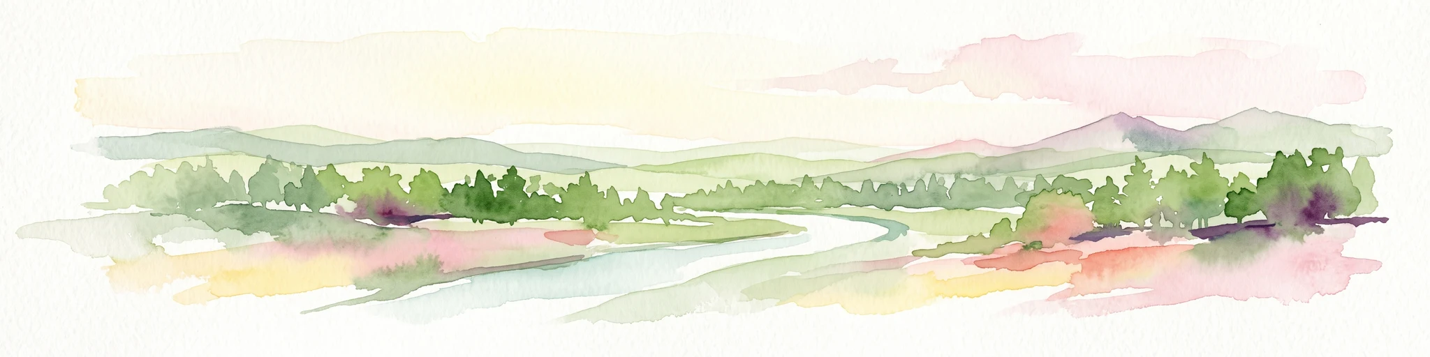
A soft watercolor illustration of a gentle river winding through green meadows and low hills under a hazy, warm sky.
Nature reserveBrandenburg
Mapped park locations coincide#1 closest

South

Europäisches Vogelschutzgebiet Nuthe-Nieplitz-Niederung Protected Area in Brandenburg

Glacial lake and river floodplain landscape context

This significant nature reserve forms a major ecological hub south of Berlin, characterized by its interplay of river floodplains, shallow glacial lakes, and open meadows. It is a critical site for breeding and migratory birds, offering a unique look at the hydrological systems and lowland geography that define the rural character of Brandenburg.

Area
61.44 km²
Established
2007
Relief
Lowland
Climate
Temperate
Nature reserveRhineland-Palatinate
About 5.7 km away#2 closest

East

Bärluch Nature Reserve: Protected Wetland Terrain and Regional Geography in Brandenburg

Post-glacial fens and swamp forest mosaic

Bärluch represents an essential protected nature reserve in Germany, defined by its bowl-shaped post-glacial depressions and diverse wetland habitats. The area preserves a rare ecological mosaic of oak-dominated forests, wet grasslands, and swampy lowland basins that provide vital breeding grounds for disturbance-sensitive bird populations and specialized regional wildlife.

Area
1.6 km²
Established
2000
Relief
Lowland
Climate
Temperate
A soft watercolor painting of a wetland landscape with rolling hills in the background, clusters of trees, and marshy foreground vegetation.
Nature reserveBrandenburg
About 18 km away#3 closest

Southeast

Stärtchen und Freibusch Nature Reserve: Protected Forest and Glacial Valley Geography

A critical habitat node within the Baruth glacial valley of Brandenburg

Stärtchen und Freibusch is a specialized nature reserve in Brandenburg that preserves a near-natural woodland mosaic. The area features a dense concentration of old-growth and deadwood habitats, fen communities, and glacial dune terrain. As a protected area, it provides essential shelter for rare flora, saproxylic beetles, and diverse avian species, contributing to the connectivity of forest corridors throughout the Teltow-Fläming district.

Area
1.787 km²
Established
2002
IUCN
IV
Watercolor painting of a peaceful wetland scene with cattails in the foreground, calm reflective water, a dense tree line on the right, and soft, rolling hills in the background.
Protected landscapeBrandenburg
About 19 km away#4 closest

Northeast

Pechpfuhl Protected Landscape: Glacial Terrain and Wetland Ecosystems in Brandenburg

A study of meltwater channels and post-glacial bog development

Pechpfuhl preserves a compact chain of wetlands created by subglacial erosion twenty thousand years ago. The landscape exhibits a transition from sandy pine-dominated dunes to a water-rich basin of alder swamps and floating bogs. As an established protected landscape, it provides critical insight into the hydrological and geological evolution of the Teltow plateau, serving as a distinct refuge for diverse bog-specific flora and fauna within the Brandenburg district.

Established
1958
Relief
Lowland
Climate
Temperate
Access
Easy access
A soft watercolor illustration showing rolling green hills, a small stream winding through the foreground, and distant purple-toned peaks against a white background.
Nature reserveBrandenburg
About 21 km away#5 closest

Northwest

Glindower Alpen: Protected Nature Reserve and Clay Mining Geography in Brandenburg

A striking post-industrial landscape and nature reserve

Glindower Alpen is a 120-hectare nature reserve near Werder, Germany, characterized by an atypical terrain of deep ravines and ridges resulting from historical clay mining. This protected area stands out as an island of mixed deciduous forests and dry grasslands amidst the broader flat geography of the Brandenburg region.

Area
1.19 km²
Established
1995
Relief
Upland
Climate
Temperate
A watercolor painting showing a horizontal landscape of green trees and reflected water against a light, misty background.
Nature reserveBrandenburg
About 23 km away#6 closest

Southeast

Schöbendorfer Busch Nature Reserve: Mapped Protected Geography in Brandenburg

Lowland deciduous forest and glacial valley landscape.

Schöbendorfer Busch provides a window into the natural heritage of the Baruther Urstromtal. This nature reserve protects over 800 hectares of forest and agricultural mosaic, serving as a primary habitat for rare saproxylic beetles and bats. Its terrain, defined by glacial meltwater deposits and wet alder swamp environments, offers a distinctive example of Brandenburg forest conservation.

Area
8.31 km²
Established
1978
IUCN
IV
A watercolor illustration showing a landscape with small clusters of trees and grassy ground under a soft, light-filled sky.
Nature reserveBrandenburg
About 24 km away#7 closest

Northwest

Lehniner Mittelheide und Quellgebiet der Emster: Nature Reserve and Protected Landscape Atlas

Mapping Brandenburg inland heath and spring valley terrain

Examine the geographic layout of Lehniner Mittelheide und Quellgebiet der Emster, a nature reserve in the Brandenburg district of Potsdam-Mittelmark. This protected area connects dry sandy heathland with the aquatic corridors of the Emster headwaters and Mühlenteich pond, offering a clear example of glacial lowland landscape integration.

Area
6.4 km²
Established
1996
IUCN
IV
Relief
Lowland
Watercolor painting of a green wetland area with soft, blurred rolling hills in the background.
Nature reserveBerlin
About 27 km away#8 closest

North

Großes Fenn Nature Reserve: Protected Peatland and Kettle Bog Geography in Berlin

A study of post-glacial landforms and mire environments.

Großes Fenn represents a rare urban kettle bog formed during the last glacial period, now protected within the Berlin region. This reserve showcases the historical peat-forming processes and the fragile ecological balance of small depressions in the Düppeler Forest, offering a compact site for understanding glacial landscape legacies.

Area
0.064 km²
Established
1986
IUCN
IV

Common questions about visiting, size, designation, and location context for Naturpark Nuthe-Nieplitz

Naturpark Nuthe-Nieplitz FAQs for park facts, access, geography, and protected area context

Find quick answers about Naturpark Nuthe-Nieplitz, including protected-area facts, park geography, trail and visitor context, and how the park fits into its surrounding country and regional landscape.
MoriAtlas Explorer

Continue Your Protected Areas Search Across the Global Atlas

Deepen your exploration by continuing the structured search for national parks and protected areas worldwide. Utilize the comprehensive filtering capabilities to compare different conservation landscapes and refine your understanding of global park geography. Discover more about the distribution and characteristics of protected natural areas.

Global natural geography