
Mori Atlas logo
Nature reserveNaturschutzgebiet Breiter Berg bei Haselstein

Mapping the forest mosaic and basalt terrain of this core biosphere reserve area

Naturschutzgebiet Breiter Berg bei Haselstein: A Protected Landscape in the Rhön Foreland

Naturschutzgebiet Breiter Berg bei Haselstein encompasses a varied 182-hectare protected area situated along the border of Hessen and Thuringia. This reserve features a dense mosaic of Central European beech forest communities, basalt blockfields, and marginal grassland habitats. As a core zone within the Rhön Biosphere Reserve and part of the Natura 2000 network, it serves as a critical node for regional biodiversity and landscape conservation.

beech forestRhön forelandbiosphere reserve core zoneNatura 2000EU birds protection areabasalt and keuper
A flat, vector-style illustration of a forest floor with fallen logs, leading toward a winding stream and a canyon with waterfalls in the background under a soft golden sky.

Naturschutzgebiet Breiter Berg bei Haselstein

Nature reserve

Park overview

Structured park overview, official facts, and landscape profile for Naturschutzgebiet Breiter Berg bei Haselstein

Naturschutzgebiet Breiter Berg bei Haselstein park facts, protected area profile, and essential visitor context

Review the core facts for Naturschutzgebiet Breiter Berg bei Haselstein, including designation, size, terrain, visitor scale, habitats, and operating context in one park-focused overview.

About Naturschutzgebiet Breiter Berg bei Haselstein

The Naturschutzgebiet Breiter Berg bei Haselstein is a forest-dominated protection area in the western Rhön foreland of northeastern Hesse. Although modest in size compared with many German national parks, it concentrates a remarkable range of Central European woodland types on a small set of hills nestled against the Thuringian border. Its protected status since 1997 layers multiple frameworks of conservation; it functions simultaneously as a small-scale nature reserve, a core zone of the Rhön UNESCO-associated Biosphere Reserve, and an integral component of the larger Hessische Rhön Special Protection Area under the EU Birds Directive.

Geographically, the reserve occupies hill country near Haselstein and Oberaschenbach, two villages of the municipality of Nüsttal. The terrain encompasses the Breiter Berg ridge, the Kielkuppe, the Schweins-Berg, and the paired Ganskuppen, all of which contribute to a landscape of gentle, partly forested ridges, small shaded stream valleys, and modest hillslopes. The bedrock variation between basalt and keuper supports a striking ecological patchwork, while the relatively undisturbed forest structure allows for the presence of old-wood features and decaying wood habitats.

Beyond its strictly forest character, the reserve includes scattered open habitats along its margins: species-rich hay meadows, fattweiden pastures, small Trollblumen-bearing wet meadows, sedge-dominated wetlands, tall-herb vegetation, and ruderal communities. These open elements act as important ecological contrasts to the dominant forest cover and create transition zones that benefit birds, insects, and amphibians associated with the Rhön uplands. The overall combination of biosphere core zone status, Natura 2000 coverage, and detailed national protection makes the Breiter Berg bei Haselstein a textbook example of layered conservation governance in a Central European low-mountain setting.

Quick facts and research context for Naturschutzgebiet Breiter Berg bei Haselstein

The Breiter Berg bei Haselstein nature reserve covers about 182 hectares in the Rhön region, sitting on the border between Hesse and Thuringia. Officially designated as a Naturschutzgebiet in 1997 under ID 1631033, it is classified as IUCN Category IV (Habitat/Species Management Area). Most of its area is registered as a core zone of the Rhön Biosphere Reserve, a status that expanded significantly in 2013.

The reserve is fully integrated into the EU Birds Directive Special Protection Area Hessische Rhön (site code DE-5425-401), placing it within the broader Natura 2000 network. Natural region classification places it in the Westliches Rhönvorland, and several named basalt and keuper hilltops such as the Breiter Berg, the Ganskuppen, and the Schweins-Berg fall within the protected boundaries.

Protection and recognition

Review documented protection status and official database identifiers for this protected area

Naturschutzgebiet Breiter Berg bei Haselstein Protection Status and Designation Records

Comprehensive protection records for Naturschutzgebiet Breiter Berg bei Haselstein outline official conservation status and administrative tracking details. Systematic database attributes compile registered boundaries and international identifiers for geographic verification.

Protection details

WDPA ID
318237
Park context

Deeper park guide and search-rich context for Naturschutzgebiet Breiter Berg bei Haselstein

Naturschutzgebiet Breiter Berg bei Haselstein history, landscape, wildlife, and travel context

Explore Naturschutzgebiet Breiter Berg bei Haselstein through its history, landscape character, ecosystems, wildlife, conservation priorities, cultural context, and seasonal travel timing in a structured park guide built for atlas discovery and search intent.

Why Naturschutzgebiet Breiter Berg bei Haselstein stands out

The reserve is best known for its exceptionally varied Central European beech forest communities on Rhön basalt and keuper substrates, including the Waldmeister-Buchenwald, Waldgersten-Buchenwald, Hainsimsen-Buchenwald, and Eichen-Hainbuchenwald. It is valued as a core zone of the Rhön Biosphere Reserve and as part of the EU Birds Protection Area Hessische Rhön, combining forest conservation with Natura 2000 obligations. A distinctive feature is the juxtaposition of mature beech-dominated forest with small-scale but ecologically important grassland and wetland elements such as Trollblumen-Feuchtwiesen, Seggenriede, Hochstaudenfluren, and Ruderalfluren. Decaying wood, old-growth relicts, and rare species like the Türkenbundlilie and Gemeine Akelei further raise the conservation value of this relatively compact Rhine-Main upland landscape.
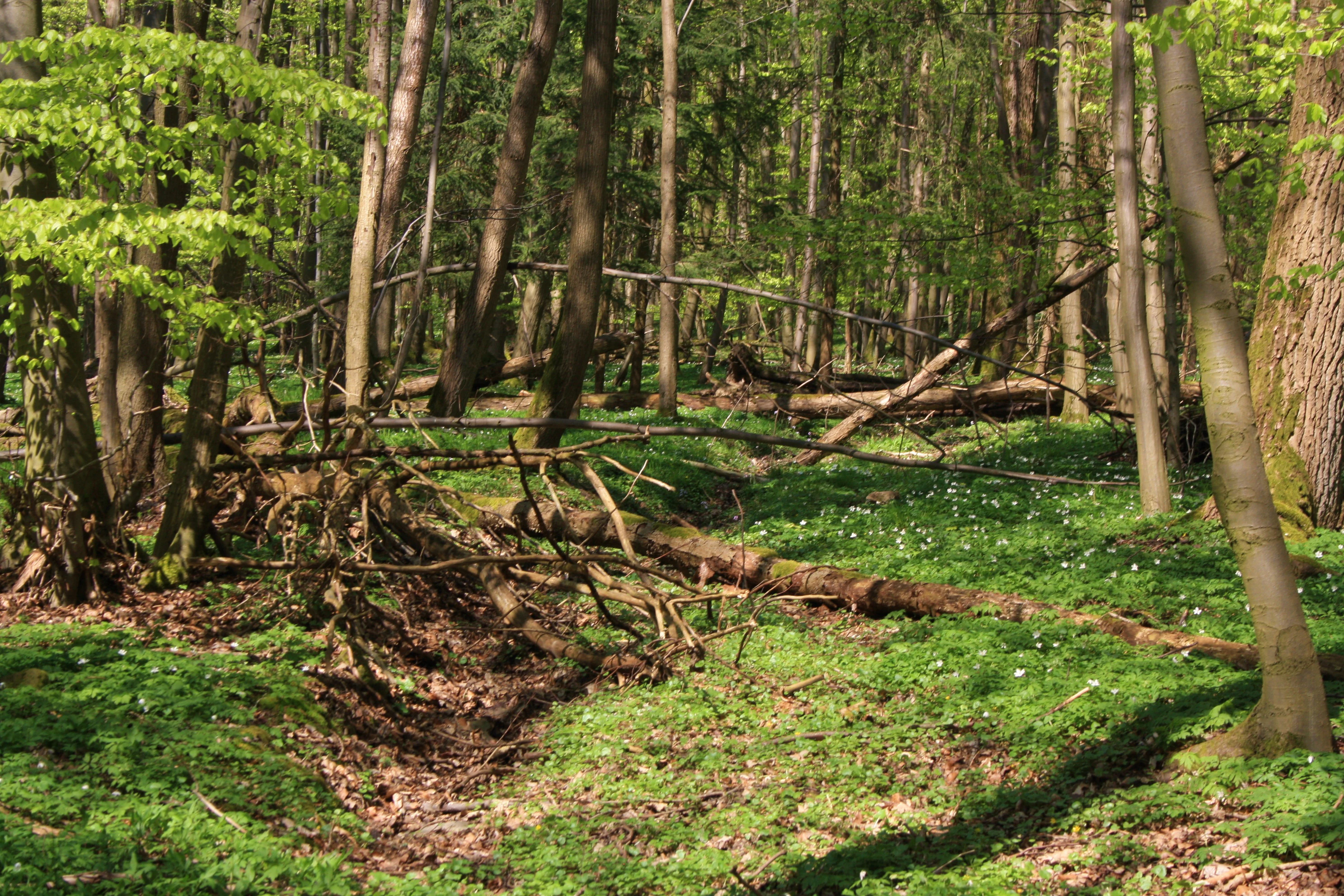
A view of a dense forest floor with fallen logs, leaf litter, and a covering of small white spring flowers under a canopy of light green leaves.
A deciduous forest floor in the Naturschutzgebiet Breiter Berg bei Haselstein during spring.

Naturschutzgebiet Breiter Berg bei Haselstein history and protected-area timeline

Even before its formal designation as a Naturschutzgebiet in 1997, the Breiter Berg area was already recognized for its conservation value. The responsible forestry office had identified a stand of old-growth forest, marking it as a long-term habitat preservation feature.

A particular historical note relates to a 14.5-hectare area where keuper bedrock reaches the surface. This site historically served as a seed-collection area for the native Winterlinde (small-leaved lime), reflecting traditional forestry practice in Hesse. With the 2013 revision of the nature reserve ordinance, however, the permit allowing this seed-harvesting activity was withdrawn, tightening the protection regime for the keuper outcrops and their associated woodland.

Designated under the Hesse nature reserve register as ID 1631033 and registered in the World Database on Protected Areas as WDPA 318237, the reserve joined the ranks of formal Hessian Naturschutzgebiete in 1997. By the early 2010s, the biosphere-related core zone within its boundaries had grown incrementally. An initial 74.8 hectares were classified as core zone even before 2011, and on 27 August 2013, the core zone was expanded by another 31.32 hectares, leaving the rest of the area under the less restrictive care zone designation of the Rhön Biosphere Reserve.

Naturschutzgebiet Breiter Berg bei Haselstein landscape and geographic character

The landscape of the Breiter Berg bei Haselstein reserve is shaped by a series of rounded hills and ridges at the northwestern edge of the Rhön highlands, where Hesse meets Thuringia. The named elevations inside the protected area, the Breiter Berg, the Kielkuppe, the Schweins-Berg, and the paired Große and Kleine Ganskuppe, collectively form a compact hill block with alternating slopes, shallow saddles, and small side valleys. Below the hill ridges, several minor brooks shape narrow valley incisions that support moisture-loving gallery forests.

Geologically, the reserve sits on a substrate mix typical of the western Rhön foreland. Basalt caps form harder, blocky terrain on some slopes, supporting steep north- and east-facing blockfields where the rare Blockschuttwald community survives. Elsewhere, keuper layers emerge, particularly on the 14.5-hectare keuper outcrop area, creating more acidic and structurally different soils that influence the vegetation patterns. The varied exposition and slope angles across the small area allow distinct microclimate zones, favoring shade-tolerant woodland on steep slopes and meadow or pasture communities on gentler or marginal land.

Visually, the landscape reads as a quietly rolling, predominantly forested upland. Small clearings and grassy strips intersect the woodland at the edges, while the higher hilltops remain cloaked in mature beech canopy. The continuous forest cover, interspersed with dead-wood features and old-growth relicts, gives the area a distinctive near-primeval woodland character despite its modest size.

Naturschutzgebiet Breiter Berg bei Haselstein ecosystems, habitats, and plant life

Ecologically, Breiter Berg bei Haselstein functions as a compact but unusually rich mosaic of Central European forest communities, a pattern driven by the convergence of basalt and keuper bedrock, slope aspect, and small-scale moisture variation. The most extensive community is the Waldmeister-Buchenwald, a sweet woodruff-type beech forest, with Waldmeister, Wald-Veilchen, Zahnwurz, and Goldnessel as common herb-layer species. On certain slopes, particularly near the Kleine Ganskuppe, the Waldgersten-Buchenwald (wood barley beechwood) is locally important, while acid-soil Hainsimsen-Buchenwald appears in small, species-poor patches.

Where the substrate shifts, the vegetation pattern shifts with it. Along streams and on slightly moist, gently sloping terrain, the Eichen-Hainbuchenwald is a key community, featuring Buche, Hainbuche, Stieleiche, and Winterlinde in approximately equal share. Adjacent fresh to moist slope areas support Eschen-Mischwald (ash-mixed forest) dominated by Berg-Ahorn and Esche, with Sharbockskraut, Ruprechtskraut, and Bärlauch prominent in the understory. In narrow bands along moist brook valleys, the Schwarzerlen-Eschen-Auwald gallery forest forms stands dominated by Schwarz-Erle, Traubenkirsche, and Esche.

A particularly distinctive and rare element is the Sommerlinden-Bergulmen-Blockschuttwald, found in only a few steep north- and east-facing basalt block-slope locations. In clearings and along forest edges, the reserve also holds grassland and wetland communities such as Goldhafer-Wiesen, Weidelgras-Fettweiden, small Trollblumen-Feuchtwiesen, Feuchtbrachen, Seggenriede, Hochstaudenfluren, and Ruderalfluren. Plant highlights include orchids as well as protected species such as the Türkenbundlilie (Lilium martagon) and Gemeine Akelei (Aquilegia vulgaris).

Naturschutzgebiet Breiter Berg bei Haselstein wildlife and species highlights

Although the German-language source emphasizes botanical composition, the reserve's status as part of the EU Birds Protection Area Hessische Rhön means it is formally managed for breeding, resting, and migratory bird species associated with the Rhön uplands. Its mosaic structure, with mature broadleaf forest, dead-wood features, open wet meadows, and tall-herb vegetation, supports a range of bird communities typical of Central European low-mountain regions.

Forest-interior features benefit woodland bird specialists, while the small scattered meadows, sedge beds, and reed-like vegetation along the wetter margins provide habitat for ground-nesting and wet-meadow species. The transitional character between forest and open land along the reserve borders creates edge zones that are particularly valuable for bird diversity. The combination of old-growth tree features, decaying wood, and undisturbed understory vegetation also supports saproxylic invertebrates and other non-avian forest fauna typical of well-structured beech woodland on basalt and keuper substrates.

Naturschutzgebiet Breiter Berg bei Haselstein conservation status and protection priorities

The Breiter Berg bei Haselstein represents a layered conservation case typical of modern German nature protection. At the base is its 1997 designation as a Hessian Naturschutzgebiet under register ID 1631033, which applies the standard national protection regime restricting damaging land-use activities. The reserve is also classified within IUCN Category IV, framing it as a Habitat/Species Management Area where active management toward specific habitat or species goals is expected.

On top of this national protection, large portions of the reserve assume stronger protection inside the Rhön Biosphere Reserve. Already before 2011, 74.8 hectares were defined as core zone, and on 27 August 2013 a further 31.32 hectares were added to the core zone, leaving only the remainder of the area in the less restrictive Pflegezone status of the biosphere framework. Combined, this means that a substantial majority of the reserve enjoys the highest level of biosphere protection.

The third conservation layer comes from European Union policy. The entire reserve lies within the Special Protection Area Hessische Rhön (Natura 2000 site code DE-5425-401), which is designated under the EU Birds Directive. This binds the area into the pan-European Natura 2000 ecological network and ensures that management addresses the habitat requirements of protected bird species. Active stewardship of old-wood islands, restriction of forest exploitation on keuper outcrops, and the 2013 cancellation of Winterlinde seed-harvesting rights illustrate the concrete management decisions that flow from this layered protection status.

Naturschutzgebiet Breiter Berg bei Haselstein cultural meaning and human context

The Breiter Berg bei Haselstein does not carry strong visible cultural landmarks in the German-language source, but it sits within a landscape shaped by centuries of Central European woodland use. Traditional forest management practices, particularly the harvesting of Winterlinde seed on keuper outcrops for forestry purposes, reflect a long-standing relationship between local communities and the beech–lime woodlands of the Rhön foreland. The cancellation of this practice in the 2013 ordinance marks a shift away from historic forestry uses toward stricter ecological protection.

The reserve is also embedded in the cultural identity of the Rhön region more broadly. As part of the Rhön Biosphere Reserve, it contributes to a landscape concept that emphasizes the interplay between traditional land use, biodiversity, and rural culture in the Rhön highlands. Villages such as Haselstein and Oberaschenbach, between which the reserve lies, represent the type of small rural communities whose historical land-use patterns still shape the open habitats along the reserve's edges.

Top sights and standout views in Naturschutzgebiet Breiter Berg bei Haselstein

The Breiter Berg bei Haselstein offers a compact but ecologically rich slice of the western Rhön foreland, with several layers of formal protection stacked onto a single 182-hectare area. Its core strengths include the rare Sommerlinden-Bergulmen-Blockschuttwald on basalt block fields, the diversity of beech forest associations on contrasting substrates, and the survival of old-wood islands first recognized long before the formal reserve designation.

Additional highlights include the reserve's biosphere core zone status, its full inclusion in the EU Birds Directive Hessische Rhön protection area, and its botanical diversity, which extends from protected wildflowers like the Türkenbundlilie and Gemeine Akelei to orchids within the herb layer. The combination of forest integrity, marginal grassland and wet-meadow habitats, and legally anchored Natura 2000 protection makes it a small but high-value node in the broader conservation network of the Rhön.

Best time to visit Naturschutzgebiet Breiter Berg bei Haselstein

The nature reserve is best experienced in late spring and early summer, when the herbaceous layer of the beech forests, including Waldmeister, Wald-Veilchen, Zahnwurz, and Goldnessel, is in full development. Late spring also offers the best chance to see the Trollblumen populations in the wet meadows at their flowering peak, while early summer brings lush green forest interiors and active breeding-bird presence.

Autumn brings a different appeal, when the beech canopy turns and the deciduous forest displays its strongest seasonal color, while mushroom and other fungal communities associated with the old-wood relicts become more visible. Winter visits are also valuable for observing the structural forest landscape, the exposed basalt block fields, and the contrast between forest and surrounding Rhön countryside under snow, although access conditions depend on weather and conservation rules.

Monthly climate preview

Long term monthly averages for temperature and precipitation at a representative elevation

Naturschutzgebiet Breiter Berg bei Haselstein Climate Normals and Temperature Rhythms

Representative coordinate measurements record annual temperature swings and monthly precipitation distributions across the protected landscape. Examining the full twelve month profile reveals detailed long term meteorological variations for research and analysis.
Annual mean8 °C
-2 °C18 °C
Jan-2°
Feb-1°
Mar
Apr
May12°
Jun16°
Jul18°
Aug18°
Sep13°
Oct
Nov
Dec-1°
Warmest month
July

18 °C

Coolest month
January

-1.6 °C

Wettest month
July

2.6 mm/day

Driest month
April

1.5 mm/day

Park location guide

Geography guide, regional context, and park location map for Naturschutzgebiet Breiter Berg bei Haselstein

Naturschutzgebiet Breiter Berg bei Haselstein park geography, regions, and map view in Germany

Understand where Naturschutzgebiet Breiter Berg bei Haselstein sits in Germany through a broader geographic reading of the surrounding landscape, nearby location context, and its mapped position within the national park landscape.

How Naturschutzgebiet Breiter Berg bei Haselstein fits into Germany

Germany is a federal republic in Western and Central Europe with a population of over 83 million across sixteen constituent states. It is Europe's largest economy by nominal GDP and a major global exporter and importer. The capital is Berlin, and the country borders Denmark, Poland, Czech Republic, Austria, Switzerland, France, Luxembourg, Belgium, and the Netherlands.

Wider geography shaping Naturschutzgebiet Breiter Berg bei Haselstein in Germany

Germany is located in Western and Central Europe, spanning 357,022 km². It borders Denmark to the north, Poland and the Czech Republic to the east, Austria and Switzerland to the south, and France, Luxembourg, Belgium, and the Netherlands to the west. The country has coastlines on the Baltic Sea and North Sea to the north, with the Alps located in the southern region.

Map view of Naturschutzgebiet Breiter Berg bei Haselstein

Use this park location map to pinpoint Naturschutzgebiet Breiter Berg bei Haselstein in Germany, understand its exact geographic position, and read its mapped placement within the surrounding landscape more clearly.

Pigeon | © OpenStreetMap contributors

Location context for Naturschutzgebiet Breiter Berg bei Haselstein

Hessen

Visualizing the beech woodlands, basalt terrain, and protected habitats of the western Rhön foreland

Naturschutzgebiet Breiter Berg bei Haselstein Landscape Photos and Scenery

Examine detailed imagery showcasing the forested slopes, basalt blockfields, and diverse habitats of Naturschutzgebiet Breiter Berg bei Haselstein. Visual records reveal the upland topography and ecological character defining this protected nature reserve.

A view of a dense forest floor with fallen logs, leaf litter, and a covering of small white spring flowers under a canopy of light green leaves.

A wooden information sign stands on a small dirt path inside a green, sunlit deciduous forest, with a second, smaller yellow sign visible further back among the trees.

Park atlas

Compare adjacent forest reserves, regional highlands, and connected conservation terrain

Parks Near Naturschutzgebiet Breiter Berg bei Haselstein and Surrounding Protected Landscapes

Browsing other protected areas near Naturschutzgebiet Breiter Berg bei Haselstein reveals the broader ecological spread of the western Rhön foreland. Evaluating adjacent woodland reserves provides essential regional context for understanding upland forest conservation networks.
Nature reserveHessen
About 11 km away#1 closest

North

Buchenberg, Grisselborner Wäldchen und Taftgrund bei Soisdorf Nature Reserve Geography

A protected habitat complex in the Hessian Kuppenrhön.

The Buchenberg, Grisselborner Wäldchen und Taftgrund bei Soisdorf reserve serves as a prime example of a balanced protected landscape. It spans deciduous woodlands, hedge-row mosaics, and valley stream habitats. This data set provides a clear view of its structured boundaries and its importance as a refuge within the northern Rhön foothills, illustrating the interplay between hilltop forest and stream-side meadow ecosystems.

Area
0.826 km²
Established
1994
Relief
Upland
Climate
Temperate
A horizontal watercolor painting showing a calm lake or pond with grassy banks and pine trees in the background, with soft mountain silhouettes under a pale sky.
Nature reserveHessen
About 14 km away#2 closest

West

Sandgrube am Mahlertshof Nature Reserve: Geography and Protected Area Context

A compact wetland sanctuary in the Hessen region of Germany.

Explore the structured landscape of Sandgrube am Mahlertshof, where former sand extraction pits have evolved into a complex of four ponds. This protected area in the municipality of Burghaun offers a prime example of ecological restoration, blending open water and marshy shorelines into a dense woodland environment that supports diverse amphibian and avian life.

Area
0.044 km²
Established
1992
Relief
Lowland
Climate
Temperate
Nature reserveHessen
About 16 km away#3 closest

Southeast

Naturschutzgebiet Westlicher Rhönwald: Protected Forest and Volcanic Geology in Hessen

Core biosphere zone and montane beech woodland reserve

Spanning 44 hectares of the Hessian Rhön, Naturschutzgebiet Westlicher Rhönwald functions as a strictly protected zone dedicated to natural forest succession. The reserve is characterized by a volcanic basalt cap over a shell limestone foundation, creating cool and moist soil conditions ideal for a diverse beech-rich canopy. It remains a focal point for understanding montane woodland development in the central European uplands.

Area
0.444 km²
Established
1997
IUCN
IV
Relief
Mountain
A watercolor illustration of a rolling natural landscape with soft green trees, light purple hills in the distance, and a pale stream or meadow in the foreground.
Nature reserveHessen
About 16 km away#4 closest

Southeast

Langenstüttig und Basaltblockmeer am Buchschirmküppel bei Batten: Protected Nature Reserve Atlas

Volcanic geology and diverse forest ecosystems in the Hessen Rhön highlands

Langenstüttig und Basaltblockmeer am Buchschirmküppel bei Batten is a significant nature reserve in the Rhön highlands of Hessen. The area is defined by its extensive basalt blockfields, locally known as Basaltblockmeer, and a mosaic of montane forests including beech, ash, and alder woodlands. This protected zone offers a clear look at how geological history and forest succession shape the natural terrain of this upland region.

Area
0.975 km²
Established
2013
IUCN
IV
A soft watercolor illustration showing rolling hills, sparse forest clusters, and rocky foreground elements, set against a light background.
Nature reserveThuringia
About 18 km away#5 closest

Northeast

Öchsenberg Nature Reserve: Basaltic Peaks and Ancient Landscapes in the Thuringian Rhön

Geographic overview of a volcanic protected area

Öchsenberg stands as a characteristic basalt dome, shaped by ancient volcanic activity and defined by its distinct scree slopes and beech woodlands. This nature reserve, located in the northern Rhön foothills, offers a concentrated landscape where geological history meets the remnants of extensive Celtic fortifications overlooking the Werra valley.

Area
2.67 km²
Established
1990
Relief
Mountain
Climate
Temperate
Nature reserveThuringia
About 19 km away#6 closest

East

Ibengarten Nature Reserve: Protected Yew Forest Landscape in the Thuringian Rhön

A historic protected area preserving rare ancient yew stands in central Germany.

Ibengarten encompasses a 56-hectare reserve in Thuringia, recognized for its dense concentration of wild European yew trees. This unique woodland environment, set against the basalt ridges of the Rhön, provides an essential look at historical conservation efforts and old-growth forest dynamics in the German low mountains.

Area
0.561 km²
Established
1938
IUCN
IV
A soft watercolor illustration of rolling green hills under a sparse, light sky.
Nature reserveHessen
About 19 km away#7 closest

North

Landecker Berg: A Detailed Look at the Nature Reserve and Mountain Geography in Hessen

Exploration of the Rhön table mountain and protected landscape.

Landecker Berg presents a classic example of a Triassic limestone massif in the northern Kuppenrhön. This nature reserve, located in the German state of Hessen, offers significant geographic interest due to its flat-topped plateau and dense forest mantle. Navigate the mapped boundaries of this protected area, which features unique geological formations, surrounding castle ruins, and an integral role in the local watershed systems.

Area
1.044 km²
Established
1992
Relief
Mountain
Climate
Temperate
Protected landscapeHesse
About 19 km away#8 closest

South

Naturpark Hessische Rhön: Geographic Profile and Protected Landscape Mapping

Mapping the Rhön low mountains and upland ecosystems in Hesse

Naturpark Hessische Rhön encompasses approximately 720 square kilometers of varied terrain north and west of Fulda. The area features a distinct mosaic of forests, streams, and protected biotope complexes. This overview provides insight into the regional geography and the conservation structure defining this prominent upland protected landscape.

Area
720 km²
Established
1962
Relief
Upland
Scope
Terrestrial

Common questions about visiting, size, designation, and location context for Naturschutzgebiet Breiter Berg bei Haselstein

Naturschutzgebiet Breiter Berg bei Haselstein FAQs for park facts, access, geography, and protected area context

Find quick answers about Naturschutzgebiet Breiter Berg bei Haselstein, including protected-area facts, park geography, trail and visitor context, and how the park fits into its surrounding country and regional landscape.
MoriAtlas Explorer

Continue Your Protected Areas Search Across the Global Atlas

Deepen your exploration by continuing the structured search for national parks and protected areas worldwide. Utilize the comprehensive filtering capabilities to compare different conservation landscapes and refine your understanding of global park geography. Discover more about the distribution and characteristics of protected natural areas.

Global natural geography