
Mori Atlas logo
Nature reserveNaturschutzgebiet Laacher See

A comprehensive geographic overview of the largest nature reserve in Rheinland-Pfalz, Germany.

Naturschutzgebiet Laacher See: Mapping the Volcanic Crater Landscape and Protected Wetland Sanctuary

Naturschutzgebiet Laacher See represents a unique geological and ecological protected area defined by its deep volcanic caldera and managed lake ecosystem. The reserve spans the crater rim in the eastern Eifel volcanic field, providing essential habitat for breeding and wintering waterbirds. This documentation explores the mapped boundaries, volcanic terrain, and seasonal water conditions that establish the area as a cornerstone of regional conservation in Germany.

volcanic lakecrater lakeEifelprotected lakewaterbird reserveNatura 2000
A stylized flat vector illustration of a lake surrounded by forested crater hills under a soft pastel sunset sky.

Naturschutzgebiet Laacher See

Nature reserve

Park overview

Structured park overview, official facts, and landscape profile for Naturschutzgebiet Laacher See

Naturschutzgebiet Laacher See park facts, protected area profile, and essential visitor context

Review the core facts for Naturschutzgebiet Laacher See, including designation, size, terrain, visitor scale, habitats, and operating context in one park-focused overview.

About Naturschutzgebiet Laacher See

Naturschutzgebiet Laacher See is the nature reserve surrounding the Laacher See, a volcanic lake in the eastern Eifel region of Rhineland-Palatinate, Germany. It lies within the Landkreis Ahrweiler and forms the largest Naturschutzgebiet in the state, with a total area of approximately 21 km². The lake itself covers about 3.59 km² and sits in a caldera that originated from a major volcanic eruption of the Eifel volcanic field centuries ago, while the surrounding crater-rim landscape, slopes, and adjacent habitats are folded into the protected boundary to ensure the wider ecological context is maintained.

The reserve belongs to the historical and ongoing system of formally designated German nature reserves, formally recognized on 31 March 1940 after an earlier unofficial protection effort in 1926. It is classified as an IUCN Category IV area, a Habitat/Species Management Area, meaning the primary management goal is to maintain specific habitats or species rather than full wilderness protection. Within European conservation frameworks, the area has overlapping designations under Natura 2000, with an FFH (Fauna-Flora-Habitat) site covering the full reserve and a separate Vogelschutzgebiet (Birds Directive site) of about 3.54 km² centered on the lake.

The core identity of the reserve, however, is ornithological. Because the Laacher See deep crater basin freezes only in extreme winters, the lake retains open water and aquatic vegetation through most cold seasons, allowing it to function as one of the more reliable lowland-style waterbird refuges in the region. This benefit is reflected in the seasonal protection schedule: when natural pressure from waterbirds is highest, between October and March, access rules are stricter; in summer, when bird need is lower, the lake is more accessible for recreation.

The wider setting also gives the reserve a strong scenic and geological dimension. The crater rim and the surrounding Eifel landscape of mixed woodland, pasture, and volcanic substrates create a transitional zone between aquatic, wetland, and terrestrial habitats. This combination of lake, crater edge, and adjoining land use is central to the reserve's identity and explains why it has been protected consistently for nearly a century.

Quick facts and research context for Naturschutzgebiet Laacher See

Naturschutzgebiet Laacher See covers about 21 km² in Landkreis Ahrweiler, Rhineland-Palatinate, and is identified as NSG-7131-006. It is classified as an IUCN Category IV Habitat/Species Management Area, with portions overlapping the Natura 2000 network as both a Fauna-Flora-Habitat (FFH) site and a Birds Directive (Vogelschutzgebiet) area. The reserve centers on the 3.59 km² Laacher See, a lake sitting in a volcanic caldera within the Eifel volcanic field.

The elevation range runs from roughly 270 m to 410 m above sea level. The reserve was first established in 1926, expanded in 1940, and reformed under a new ordinance on 1 April 1981, which was later extended on 14 December 1989. It is the largest Naturschutzgebiet in Rhineland-Palatinate and is recognized in international databases including the World Database on Protected Areas.

Protection and recognition

Review official protected area designation records and conservation registry entries for this protected landscape.

Naturschutzgebiet Laacher See Protection Status and Documented Conservation Data

Consolidated registry records outline the documented protection status and official designation history for Naturschutzgebiet Laacher See. Structured conservation data provides reliable reference metrics for researchers examining international protected area databases.

Protection details

WDPA ID
4398
Park context

Deeper park guide and search-rich context for Naturschutzgebiet Laacher See

Naturschutzgebiet Laacher See history, landscape, wildlife, and travel context

Explore Naturschutzgebiet Laacher See through its history, landscape character, ecosystems, wildlife, conservation priorities, cultural context, and seasonal travel timing in a structured park guide built for atlas discovery and search intent.

Why Naturschutzgebiet Laacher See stands out

The reserve is known above all for the Laacher See lake as a wintering and staging habitat for waterbirds in the Eifel. Its deep crater basin rarely freezes completely, which makes it a reliable refuge for waterfowl during the colder months and a breeding ground for species such as grebes, coots, moorhens, reed warblers and reed buntings in the warmer seasons. Beyond its ornithological value, the area is defined by its volcanic origin. The lake occupies a caldera in the Eifel volcanic field, and the surrounding crater rim and pumice-deposited landscape are integral to the protected area. The reserve thus pairs classic Eifel volcanic scenery with a focused wetland conservation identity centered on a single, relatively large lake.
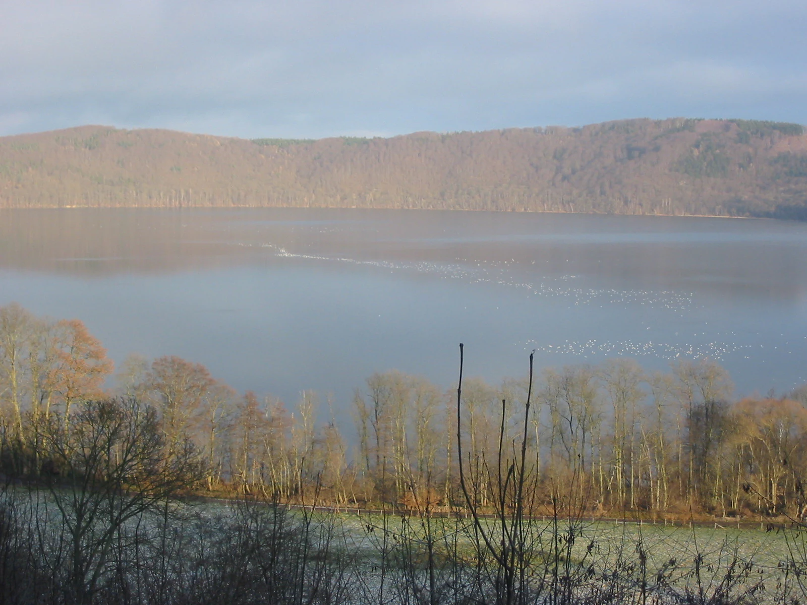
A wide view overlooking the Laacher See lake, featuring calm water, tree-lined shores, and forested crater rim hills under a hazy sky.
A view across the calm waters of Laacher See, the centerpiece of the nature reserve.

Naturschutzgebiet Laacher See history and protected-area timeline

Protection of the Laacher See area traces back to the early twentieth century, when growing awareness of the lake's ecological importance led to the founding of a precursor protection arrangement in 1926. As pumice mining (Bimsabbau) in the area expanded, the boundaries needed to be redrawn to protect the lake and its surroundings more comprehensively. The reserve was therefore formally re-established on 31 March 1940 in its modern extent.

Earlier centuries had left a different kind of mark: two drainage tunnels were cut in earlier times, lowering the natural water level of the Laacher See by roughly twelve meters compared to its original state. A planned use of the area under the 'Kraft durch Freude' program of the National Socialist regime was not realized. After the Second World War, public interest in the lake increased substantially, turning it into a recognized local tourism destination.

The tension between natural protection and recreational use became a recurring concern. To manage this more effectively, a new ordinance was put into force on 1 April 1981, replacing earlier arrangements, and on 14 December 1989 the regulations were once again extended. Since then, sports activities and camping have been permitted only between 15 April and 30 September, aligning human use with the seasons when waterbird pressure on the lake is lowest and aligning protection effort with the seasons when it is highest.

Naturschutzgebiet Laacher See landscape and geographic character

The defining landscape feature of the reserve is the Laacher See itself: a roughly 3.59 km² lake occupying a deep caldera within the eastern Eifel volcanic field. The lake basin is steep-sided, the result of its volcanic origin, and the higher ground of the crater rim forms the boundary of the protected area on several sides. Elevation across the reserve ranges from about 270 m to 410 m above sea level, giving the landscape a compact sense of vertical relief despite the relatively small geographic extent.

Around the lake, the terrain is shaped by Eifel volcanic geology. The surrounding slopes carry traces of volcanic deposits, including pumice (Bims), and historically supported pumice mining activity that influenced the reserve's boundaries. The wider Eifel landscape context includes mixed woodland, fields, pastures, and scattered volcanic landforms typical of this part of Rhineland-Palatinate. The reserve thus presents a sharp contrast between the open water of the lake and the more forested, undulating slopes of the crater rim.

Two historical drainage tunnels, cut to lower the lake's water level, have reshaped the shoreline. Today's waterline sits approximately twelve meters below the lake's natural historical level, exposing former lakebed zones along parts of the margin and altering the original shallow-water zones that would have existed. The reservoir remains, however, a large open body of water at this elevation and retains its character as the dominant landscape feature of the area.

Naturschutzgebiet Laacher See ecosystems, habitats, and plant life

Ecologically, Naturschutzgebiet Laacher See functions primarily as a lake and lake-fringe reserve. The lake itself forms the most important habitat unit, with open water, submerged vegetation, and fringing reed belts typical of a temperate eutrophic lake ecosystem. Around the lake, the crater-rim slopes provide a terrestrial complement: woodland, semi-open habitats, and Eifel volcanic substrates that together create a habitat mosaic at relatively small scale but high habitat density.

The reserve sits at the junction of aquatic, wetland, and terrestrial systems. Aquatic habitat dominates the lake center, while reed and shore vegetation line parts of the margin. The adjacent crater rim contributes forest and scrub habitat, while the surrounding Eifel landscape connects the reserve to broader woodland and agricultural mosaic ecosystems. This combination is what gives the area its value beyond a single habitat type, allowing multiple ecological communities to coexist within the protected boundary.

Within European conservation frameworks, the area's ecological significance is formally recognized. The reserve is designated as a Fauna-Flora-Habitat (FFH) site covering its full area, and a separate Vogelschutzgebiet (Birds Directive site) of roughly 3.54 km² protects the lake itself. The dual designation underlines the lake's importance both as a general habitat and, more specifically, as a bird protection area.

Naturschutzgebiet Laacher See wildlife and species highlights

Wildlife interest in Naturschutzgebiet Laacher See concentrates overwhelmingly on birds. The lake is recognized as an important breeding area for waterbirds, with species such as the great crested grebe (Haubentaucher), Eurasian coot (Blessralle), common moorhen (Teichralle), Eurasian reed warbler (Teichrohrsänger), and reed bunting (Rohrammer) breeding in the lake and its reed margins. These species depend on the open water and reed belt maintained through the reserve's management approach.

The lake's role extends into the cold half of the year. Because complete freezing is rare and limited to the harshest winters, the reservoir generally retains open water through autumn and winter, making it an important staging and wintering (Rast- und Überwinterungs) site for waterbirds otherwise excluded from frozen lake surfaces. Winter visitors regularly observed include common goldeneye (Schellente), common pochard (Tafelente), tufted duck (Reiherente), and Eurasian teal (Krickente).

This seasonal distinction between breeding and wintering use is built directly into the management of the reserve. Protection is intensified from October through March, when waterbird dependence is highest, while access for tourism is allowed more freely from April through September. The result is a single lake that, in ecological terms, functions differently across the year: a breeding ground in the warm months and a winter refuge in the cold ones.

Naturschutzgebiet Laacher See conservation status and protection priorities

Conservation significance at Naturschutzgebiet Laacher See rests on the lake's role as a refuge and breeding site for waterbirds, supported by its protected status under multiple tiers of European and national law. As an IUCN Category IV area, the management goal is targeted habitat and species protection rather than full wilderness designation, and the reserve is integrated into the Natura 2000 network as both an FFH site and a Birds Directive site.

The lake's value as a wintering site is the main conservation driver. Because most shallow or smaller water bodies in the region freeze regularly in winter, a deep volcanic lake that does so only in the most extreme conditions is unusually valuable. Protection regulations reflect this: stricter rules and limited access from October to March reduce disturbance to wintering and staging waterbirds, while summer access is more open to balance public recreation against the lower ecological pressure of the warm season.

Long-term management history reflects ongoing adjustment of boundaries and rules. Early protection in 1926 was rewritten and expanded in 1940 to address pumice mining pressure, then again reformed under a 1981 ordinance and further updated in 1989. The reserve is also referenced in the World Database on Protected Areas (WDPA), confirming its international profile and durable recognition.

Naturschutzgebiet Laacher See cultural meaning and human context

The Laacher See holds a distinct place in the cultural geography of the Eifel beyond its strictly ecological value. The lake is closely associated with the nearby Abtei Maria Laach, a well-known Benedictine abbey whose presence has long framed how visitors experience the area. The reserve thus sits within a landscape where religious, architectural, and natural heritage overlap, and the lake is part of an established regional identity rather than a remote wilderness.

Earlier human activity has also shaped the lake's physical form. Two historical drainage tunnels were cut in earlier centuries, lowering the water level by roughly twelve meters. Pumice mining (Bimsabbau) near the crater rim influenced later boundary changes, and the failed 'Kraft durch Freude' plan of the 1940s shows how the area was considered for organized mass tourism before the Second World War shifted those plans.

In the postwar period, tourism around the lake grew steadily, creating a modern tension between recreation and conservation that the reserve's ordnances continuously try to manage. Today the lake belongs both to residents of Landkreis Ahrweiler and to visitors from across the Rhineland and beyond, and its protected status reflects that dual identity.

Top sights and standout views in Naturschutzgebiet Laacher See

The standout features of Naturschutzgebiet Laacher See are the volcanic lake itself, the unusually reliable open-water conditions through most winters, and the careful seasonal balance between strict bird protection and summer recreation. The reserve's full Natura 2000 coverage and dual FFH plus Birds Directive status underline its formal ecological weight, while the surrounding crater-rim landscape gives the area a clear geological identity.

Internationally, the site is recorded in the World Database on Protected Areas under WDPA-ID 4398, and at the national scale it stands as the largest Naturschutzgebiet in Rhineland-Palatinate. Its long management history, from 1926 to successive post-war ordinances, reflects sustained institutional attention to a relatively small but ecologically important lake.

Best time to visit Naturschutzgebiet Laacher See

The character of a visit shifts meaningfully with the seasons because the reserve's regulations are tied directly to ecological need. From October through March, protection is at its strictest, and access to the lake margin and adjacent areas is more restricted; this is also the period when waterbird presence is at its peak and when the lake most clearly demonstrates its value as a winter refuge for waterfowl.

From April through September, the reserve's rules open up: sports and camping are permitted between 15 April and 30 September, and the lake becomes more accessible to general recreation. Warmer months are therefore better suited to visitors interested in the broader crater-rim scenery and landscape experience, while winter visits, where permitted, offer the most rewarding birdwatching context. Visitors should generally align their timing with the seasonal balance the reserve itself is designed around.

Monthly climate preview

Long-term representative monthly temperature and precipitation rhythms

Naturschutzgebiet Laacher See Climate Normals and Annual Temperature Range

Representative coordinates record measured multiyear temperature variation alongside consistent daily precipitation averages across twelve distinct cycles. Detailed monthly comparisons illustrate the full climatological rhythm established for this protected geography.
Annual mean9 °C
0 °C19 °C
Jan
Feb
Mar
Apr
May13°
Jun16°
Jul19°
Aug18°
Sep14°
Oct
Nov
Dec
Warmest month
July

18.7 °C

Coolest month
January

0 °C

Wettest month
December

2.5 mm/day

Driest month
April

1.6 mm/day

Park location guide

Geography guide, regional context, and park location map for Naturschutzgebiet Laacher See

Naturschutzgebiet Laacher See park geography, regions, and map view in Germany

Understand where Naturschutzgebiet Laacher See sits in Germany through a broader geographic reading of the surrounding landscape, nearby location context, and its mapped position within the national park landscape.

How Naturschutzgebiet Laacher See fits into Germany

Germany is a federal republic in Western and Central Europe with a population of over 83 million across sixteen constituent states. It is Europe's largest economy by nominal GDP and a major global exporter and importer. The capital is Berlin, and the country borders Denmark, Poland, Czech Republic, Austria, Switzerland, France, Luxembourg, Belgium, and the Netherlands.

Wider geography shaping Naturschutzgebiet Laacher See in Germany

Germany is located in Western and Central Europe, spanning 357,022 km². It borders Denmark to the north, Poland and the Czech Republic to the east, Austria and Switzerland to the south, and France, Luxembourg, Belgium, and the Netherlands to the west. The country has coastlines on the Baltic Sea and North Sea to the north, with the Alps located in the southern region.

Map view of Naturschutzgebiet Laacher See

Use this park location map to pinpoint Naturschutzgebiet Laacher See in Germany, understand its exact geographic position, and read its mapped placement within the surrounding landscape more clearly.

Pigeon | © OpenStreetMap contributors

Location context for Naturschutzgebiet Laacher See

Rheinland-Pfalz

Visual reference of caldera terrain, crater rims, and waterbird habitats

Naturschutzgebiet Laacher See Landscape Photos and Volcanic Scenery

Visual documentation of Naturschutzgebiet Laacher See reveals the dramatic topography of its volcanic caldera and surrounding crater slopes. Examining these protected area photographs provides clear insight into the diverse wetland environments and wintering waterbird habitats characterizing the region.

A wide view overlooking the Laacher See lake, featuring calm water, tree-lined shores, and forested crater rim hills under a hazy sky.

Park atlas

Compare adjacent volcanic landscapes and regional nature reserves

Other Parks Near Naturschutzgebiet Laacher See and Surrounding Protected Areas

Browse other parks near Naturschutzgebiet Laacher See to examine connected protected landscapes and regional volcanic terrain. Expanding the geographic comparison reveals broader ecological patterns across the wider Eifel conservation area.
A watercolor painting showing a reddish-brown layered geological formation, likely a quarry or volcanic cliff, topped with trees, with softer green hills in the distance.
Nature reserveRhineland-Palatinate
About 5.6 km away#1 closest

East

Nastberg Nature Reserve: Volcanic Geology and Protected Landscapes in Rhineland-Palatinate

Tracing volcanic fissures and scoria cone history in the Middle Rhine region

Nastberg represents a significant geological site within the Vulkanpark network. The nature reserve exposes complex layers of tuff and scoria, documenting a long history of explosive activity. With views extending across the Neuwied Basin toward the Westerwald and Hunsrück, this site offers deep insight into the regional volcanic geography of western Germany.

Relief
Mountain
Climate
Temperate
Access
Easy access
Scope
Terrestrial
A soft watercolor painting of a green, rolling hillside with trees, set against a pale, light-filled background.
Nature reserveRhineland-Palatinate
About 5.8 km away#2 closest

Southwest

Hochstein Nature Reserve: Geological Mapping and Protected Eifel Landscape Context

An extinct volcanic cone protected within Rhineland-Palatinate

Hochstein stands as a representative Vulkanberg in the Osteifel, offering a clear visual landmark of Germany's volcanic history. This protected nature reserve encompasses forested slopes, the storied Genoveva Cave, and the surrounding drainage basins of the Nette river system, providing a deep look into the regional geology and conservation boundaries of the Middle Rhine highland.

Area
3.511 km²
Established
1983
Relief
Mountain
Scope
Terrestrial
Nature reserveRheinland-Pfalz
About 7 km away#3 closest

Northwest

Bausenberg Nature Reserve: Geological Scoria Cone and Volcanic Landscape in Rhineland-Palatinate

Protected Eifel volcanic terrain and ancient earthwork geography.

Bausenberg serves as a protected window into eastern Eifel volcanism, showcasing a classic scoria cone and horseshoe-shaped crater profile. Located between Niederzissen and Waldorf, this 127-hectare reserve preserves critical lava-flow remnants and rare habitats, offering a deep look at the volcanic and human history shaped into the landscape of Rhineland-Palatinate.

Area
1.27 km²
Established
1981
Relief
Mountain
Climate
Temperate
Nature reserveRhineland-Palatinate
About 7.3 km away#4 closest

Southeast

Nettetal Nature Reserve: Geography and Protected Boundaries in Rhineland-Palatinate

Steep-sided valley landscapes and biodiversity corridors.

Nettetal Nature Reserve offers a deep look into the geomorphology of a classic Kerbtal in Rhineland-Palatinate. This protected area along the Nette tributary showcases a rare density of contrasting terrains, from sun-exposed rock formations to damp valley floors, providing a clear window into regional conservation mapping.

Area
7.05 km²
Established
1986
Scope
Terrestrial
Water
Major water bodies
A horizontal watercolor painting showing a soft, stylized landscape of green rolling hills and volcanic peaks behind a line of pine trees and a calm body of water in the foreground.
Nature reserveRheinland-Pfalz
About 7.7 km away#5 closest

Southwest

Hochsimmer Nature Reserve: Volcanic Topography and Forested Highlands of the Eastern Eifel

A study of basaltic twin cones and protected regional wilderness

Hochsimmer is a well-defined volcanic cinder cone near the Mayen-Koblenz district, characterized by its twin-peak profile and expansive woodland canopy. This protected nature reserve anchors the local topography where the volcanic Eifel meets the Middle Rhine basin, offering an essential reference for understanding the geological and ecological structure of the Rhineland-Palatinate high country.

Area
2.491 km²
Established
1973
Relief
Mountain
Climate
Temperate
Nature reserveRhineland-Palatinate
About 7.8 km away#6 closest

West

Lehrenkopf Nature Reserve: Mapped Volcanic Terrain and Regional Eifel Geography

Geological landscape and protected botanical site in Ahrweiler

Lehrenkopf stands as a compact nature reserve characterized by its 496-meter volcanic hill, which anchors the botanical and geological identity of the site. Spanning across the municipal territories of Kempenich and Brenk, this protected area serves as a focal point for regional conservation within the Eifel, emphasizing the preservation of rare wild plant species and the maintenance of distinct skyline features in the Ahrweiler district.

Area
0.35 km²
Established
1989
IUCN
IV
Relief
Mountain
A horizontal watercolor painting showing a soft, minimalist landscape of a winding river surrounded by low green hills and floodplain vegetation on a white background.
Nature reserveRhineland-Palatinate
About 8.5 km away#7 closest

Northeast

Namedyer Werth Nature Reserve: A Geographical Overview of the Middle Rhine Floodplain

Examining riparian habitat, river dynamics, and protected terrain.

Namedyer Werth stands as a significant nature reserve on the left bank of the Middle Rhine, showcasing restored floodplain forest and important bird habitats. This compact landscape, once a river island, provides a fascinating look at how transport infrastructure and natural conservation coexist. Examine the site as a key component of the Rhine river geography, famous for the Andernach cold-water geyser and its layered environmental history.

Established
1985
A watercolor painting showing a rocky, layered cliff face in the center, surrounded by green foliage, with rolling hills and a mountain range in the background against a white backdrop.
Protected areaRheinland-Pfalz
About 8.9 km away#8 closest

South

Mayener Grubenfeld: Protected Industrial Landscapes and Volcanic Terrain in Germany

A historic basalt mining district and vital bat hibernation hub

The Mayener Grubenfeld preserves deep traces of volcanic activity and industrial evolution, marked by porous basalt sheets and centuries of extraction. Today, the terrain consists of abandoned quarry pits, gallery systems, and dry grassland habitats that form a protected area of significant geological and ecological value within Rheinland-Pfalz.

Area
1.5 km²
Relief
Upland
Climate
Temperate
Access
Easy access

Common questions about visiting, size, designation, and location context for Naturschutzgebiet Laacher See

Naturschutzgebiet Laacher See FAQs for park facts, access, geography, and protected area context

Find quick answers about Naturschutzgebiet Laacher See, including protected-area facts, park geography, trail and visitor context, and how the park fits into its surrounding country and regional landscape.
MoriAtlas Explorer

Continue Your Protected Areas Search Across the Global Atlas

Deepen your exploration by continuing the structured search for national parks and protected areas worldwide. Utilize the comprehensive filtering capabilities to compare different conservation landscapes and refine your understanding of global park geography. Discover more about the distribution and characteristics of protected natural areas.

Global natural geography