
Mori Atlas logo
Nature reserveNaturschutzgebiet Scheffelberg / Kalberstert

Tracing the limestone outcrops, dry grasslands, and protected ecological terrain of the Hochsauerlandkreis region

Naturschutzgebiet Scheffelberg / Kalberstert: A Geographically Significant Limestone Hill Nature Reserve

(Naturschutzgebiet Scheffelberg / Kalberstert (HSK-541))

The Naturschutzgebiet Scheffelberg / Kalberstert encompasses four distinct limestone hilltops rising above the agricultural landscape near Brilon. This nature reserve serves as a prime example of Massenkalk geology, featuring exposed rock formations, scree slopes, and calcareous dry grasslands. Our mapping traces the structural diversity of these hill habitats, providing geographic context for the complex mosaic of beech groves, rough pastures, and protected slopes that define this upland area.

limestone hillsKalkkuppencalcareous dry grasslandKalkhalbtrockenrasenrock outcropsscree slopes
A stylized vector illustration of a landscape featuring green hills, trees, a river, and a waterfall flowing through a valley with cliffs in the background.

Naturschutzgebiet Scheffelberg / Kalberstert

Nature reserve

Park overview

Structured park overview, official facts, and landscape profile for Naturschutzgebiet Scheffelberg / Kalberstert

Naturschutzgebiet Scheffelberg / Kalberstert park facts, protected area profile, and essential visitor context

Review the core facts for Naturschutzgebiet Scheffelberg / Kalberstert, including designation, size, terrain, visitor scale, habitats, and operating context in one park-focused overview.

About Naturschutzgebiet Scheffelberg / Kalberstert

The Naturschutzgebiet Scheffelberg / Kalberstert lies east of Brilon, in the northern Sauerland region of North Rhine-Westphalia, and forms one of 31 protected limestone hill reserves belonging to the Brilon group of Kalkkuppen. The reserve is built around four named elevations, namely Kleiner Scheffelberg, Großer Scheffelberg, Gaus and Kalberstert, with exposed limestone cliffs at the summits of Großer Scheffelberg and Kalberstert giving the landscape its distinctive silhouette.

Geologically, the area belongs to the Massenkalk belt that runs through this part of the Sauerland, producing shallow soils, rock outcrops, scree slopes and small disused quarries. These calcareous substrates support a particularly rich flora, including flower-rich calcareous dry grasslands along the steeper rocky crests and a mosaic of lean pastures, hedges, shrub lines and tree groups across the gentler slopes. Small beech groves of the woodland-rye type (Waldmeister-Buchenwald) cling to the northern edges of the smaller hill.

In landscape terms, the site sits within an open agricultural setting, where the green hilltops break an otherwise continuous farmland mosaic. The unusual combination of open rock, scree, dry grassland, pasture and small beech woodland within a compact area gives the reserve strong ecological and scenic value. Because of its botanical richness and the presence of several nationally rare plant species, it has long been recognised as an important component of the regional network of calcareous grassland and limestone hill habitats extending across the Brilon plateau.

Quick facts and research context for Naturschutzgebiet Scheffelberg / Kalberstert

The reserve covers roughly 45.6 hectares near Brilon in the Hochsauerlandkreis and was designated as a nature reserve in 2008 through the Briloner Hochfläche landscape plan. It includes four named hilltops: Kleiner Scheffelberg, Großer Scheffelberg, Gaus and Kalberstert. Three sub-areas belong to the FFH site Kalkkuppen bei Brilon (DE 4617-303), and the reserve has also been part of the SPA Diemel- und Hoppecketal mit angrenzenden Wäldern since 2023. Geologically, the area is built on Massenkalk, a dense local limestone that produces exposed rock, scree and shallow soils supporting calcareous grassland flora.

Protection and recognition

Documented terrestrial conservation scope and official designation records

Naturschutzgebiet Scheffelberg / Kalberstert Protection Status and Recognition

Terrestrial protection status for Naturschutzgebiet Scheffelberg / Kalberstert outlines the documented conservation scope and management framework. Official records compile available designation data to provide a clear baseline for this protected area.

Protection details

Protection scope
Terrestrial
Transboundary protection
No
Park context

Deeper park guide and search-rich context for Naturschutzgebiet Scheffelberg / Kalberstert

Naturschutzgebiet Scheffelberg / Kalberstert history, landscape, wildlife, and travel context

Explore Naturschutzgebiet Scheffelberg / Kalberstert through its history, landscape character, ecosystems, wildlife, conservation priorities, cultural context, and seasonal travel timing in a structured park guide built for atlas discovery and search intent.

Why Naturschutzgebiet Scheffelberg / Kalberstert stands out

The reserve is especially known for the conical Kalberstert limestone rock outcrop, which rises openly above the surrounding farmland with exposed rock on its summit. Equally significant are its flower-rich Kalkhalbtrockenrasen, or calcareous dry grasslands, which cover the upper slopes of Großer Scheffelberg and the smaller Scheffelberg hill and pass into structurally diverse lean pastures further downslope. The combination of Massenkalk geology, open rocky outcrops, scree, beech groves and lightly grazed meadows makes the site a textbook example of the Brilon limestone hill landscape.
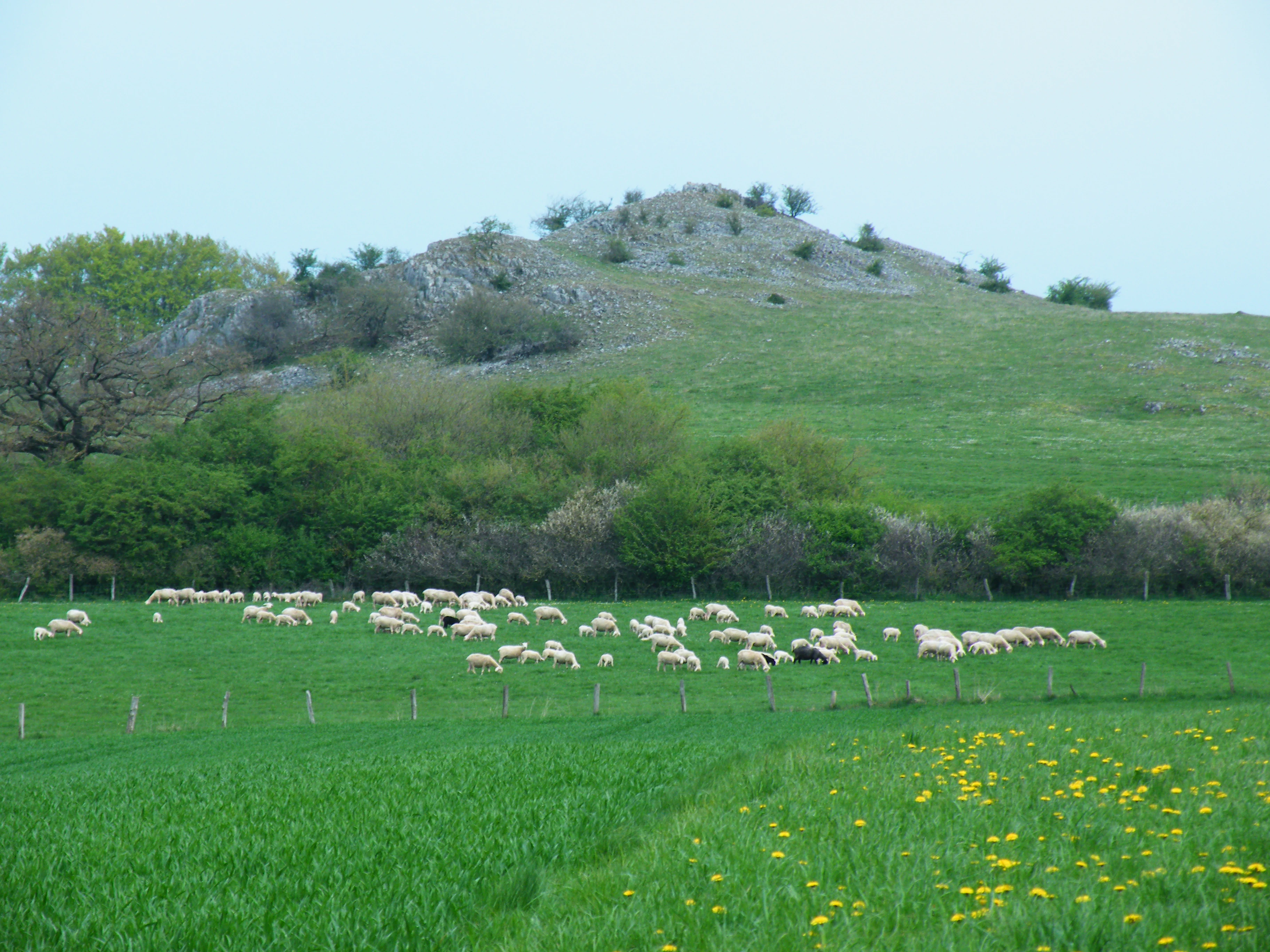
Wide landscape view of a green pasture with a large flock of sheep grazing, a line of trees, and a rocky hill in the background under an overcast sky.
A flock of sheep grazes in a lush green meadow at the foot of the rocky Kalberstert hill within the nature reserve.

Naturschutzgebiet Scheffelberg / Kalberstert history and protected-area timeline

The area's modern conservation history began with the 2008 landscape plan for the Briloner Hochfläche, through which the Hochsauerlandkreis formally designated the four hilltops as the Naturschutzgebiet Scheffelberg / Kalberstert. The designation explicitly recognised the rarity, special character and beauty of the area.

Its protected status was reinforced in 2023, when the nature reserve was incorporated into the larger Vogelschutzgebiet Diemel- und Hoppecketal mit angrenzenden Wäldern, giving it additional importance for the conservation of breeding and migrating birds in the region. Three of its sub-areas had already been included in the European FFH site Kalkkuppen bei Brilon (DE 4617-303) under the EU Habitats Directive, anchoring the reserve firmly within the Natura 2000 network.

Earlier evidence of human use is preserved in small landforms such as Pingen, shallow historic mining hollows that reflect the long-standing human interest in the local limestone. A small former quarry on the northern edge of Kleiner Scheffelberg has since been recolonised by shrubs, illustrating how past extraction has left subtle traces in today's mosaic of rock, scrub and meadow.

Naturschutzgebiet Scheffelberg / Kalberstert landscape and geographic character

The landscape of the reserve is defined by four closely grouped limestone hilltops that rise above the open farmland east of Brilon. The most prominent of these is the Kalberstert, a near-conical Massenkalk rock outcrop with almost no shrubs on its summit, so that bare limestone and scree dominate the skyline. Next to it stand Großer Scheffelberg, with its steep rocky eastern flank and broader terraced slopes, and Kleiner Scheffelberg, whose flatter summit carries a halo of dry grassland encircled by small beech groves and hedges.
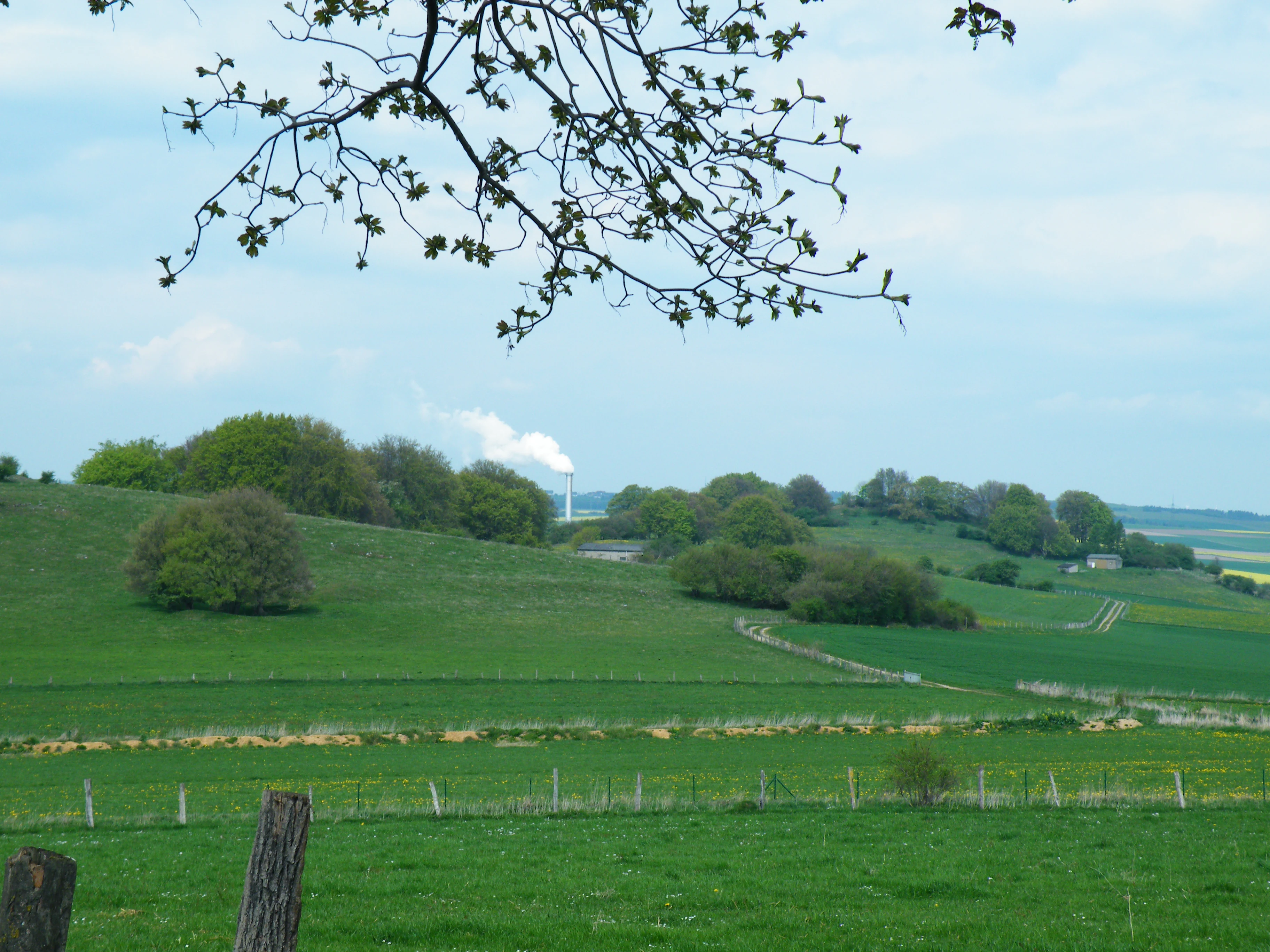
A landscape view of rolling green hills and fields with scattered trees, a wooden fence in the foreground, and a power plant chimney emitting white smoke in the background under a partly cloudy sky, framed by a tree branch at the top.
View of the Scheffelberg area with rolling green hills, scattered trees, and the Egger chimney in the distance.

Naturschutzgebiet Scheffelberg / Kalberstert ecosystems, habitats, and plant life

The reserve protects an unusually compact ecological mosaic, in which botanical diversity is closely tied to the underlying Massenkalk geology. The open rock of the Kalberstert supports a distinctive community of small ferns and cryptogams, surrounded by scree and flower-rich calcareous dry grasslands. On the broader slopes of Großer Scheffelberg and Kleiner Scheffelberg the same ecological pattern repeats: dry calcareous grasslands cap the stoniest and shallowest ground, lean pastures cover the somewhat deeper soils, and hedges, single trees and beech clumps add structural variety.

The botanical inventory recorded by the Landesamt für Natur, Umwelt und Verbraucherschutz Nordrhein-Westfalen includes a long list of characteristic species of these habitats, such as Spring-sedge, Ox-eye daisy of nutrient-poor meadows, Carthusian pink relatives, Globe-thistle, Large-flowered self-heal, and several orchids, notably the Early-purple orchid (Männliches Knabenkraut). The presence of heliophytes and stress-tolerant species together with woodland-edge plants in the beech fringes reflects the very fine-scale transition from rock and dry grassland into closed forest that is typical of the best Brilon limestone hills.
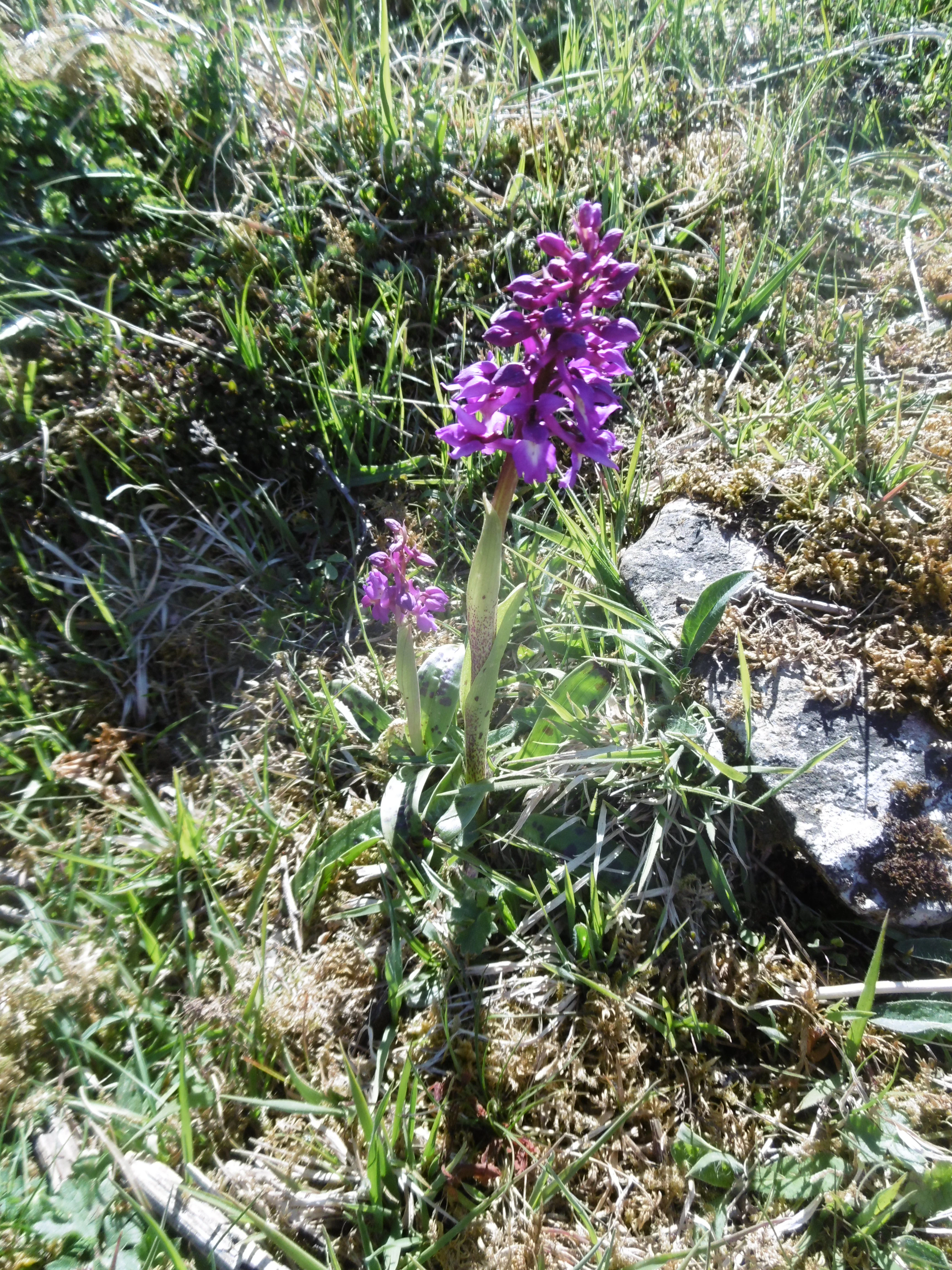
A purple orchid flower spike growing among grass and moss on rocky ground in a nature reserve
Manns Knabenkraut (Orchis mascula) blooming in the Scheffelberg and Kalberstert nature reserve

Naturschutzgebiet Scheffelberg / Kalberstert conservation status and protection priorities

The reserve's principal conservation value lies in its role as a refuge for calcareous grassland flora and associated fauna within the wider Brilon limestone hill network. The designation was issued to preserve and optimise a species-rich biotope mosaic of lean meadows, rock habitats and limestone beech groves, especially for species that are rare or threatened at regional or national level.

Its inclusion in the EU Habitats Directive site Kalkkuppen bei Brilon (DE 4617-303) and, from 2023, in the Vogelschutzgebiet Diemel- und Hoppecketal mit angrenzenden Wäldern, places the area firmly within the Natura 2000 network and underscores its contribution to European-scale habitat coherence. Special management rules apply to the Kalkkuppen core zones, including a ban on fertilising, rolling and harrowing the hilltops, a grazing cap of two livestock units per hectare, and a hay-cutting date no earlier than 1 July, helping to maintain the open, nutrient-poor conditions on which the grassland flora depends.

Naturschutzgebiet Scheffelberg / Kalberstert cultural meaning and human context

The reserve's cultural context is closely tied to the rural character of the Brilon Hochfläche and to the long human relationship with the local limestone. The landforms known as Pingen near the Kalberstert and a small former quarry on the northern edge of Kleiner Scheffelberg bear witness to historic limestone use and give the protected area a subtle cultural-historical dimension alongside its natural value. The wider network of Kalkkuppen reserves around Brilon has long been recognised by the regional landscape planning authority as part of the cultural-natural identity of the Sauerland uplands.

Best time to visit Naturschutzgebiet Scheffelberg / Kalberstert

Late spring and early summer are the most rewarding times to see the reserve's botanical richness, when the calcareous dry grasslands on the Kalberstert and the two Scheffelberg hills come into flower and wild orchids such as the Early-purple orchid are most easily observed. Summer continues to offer abundant insect activity on the warm rocky slopes, while late summer and early autumn provide a good view of the structural contrast between dry grassland, hedges and beech groves. In winter the open landforms of the four hilltops stand out sharply against the surrounding farmland, especially when a light snow cover emphasises the cone of the Kalberstert.

Monthly climate preview

Annual temperature ranges and monthly precipitation patterns derived from long-term coordinate sampling

Naturschutzgebiet Scheffelberg / Kalberstert Average Temperature and Precipitation Normals

Representative point measurements reveal the long-term annual temperature cycle and monthly precipitation rhythm recorded across Naturschutzgebiet Scheffelberg / Kalberstert from 1991 to 2020. Analyzing these twelve-month baseline averages provides a clearer meteorological profile of the local terrain before examining full monthly breakdowns.
Annual mean9 °C
0 °C18 °C
Jan
Feb
Mar
Apr
May12°
Jun15°
Jul18°
Aug18°
Sep14°
Oct
Nov
Dec
Warmest month
July

18 °C

Coolest month
January

-0.2 °C

Wettest month
July

2.6 mm/day

Driest month
April

1.7 mm/day

Park location guide

Geography guide, regional context, and park location map for Naturschutzgebiet Scheffelberg / Kalberstert

Naturschutzgebiet Scheffelberg / Kalberstert park geography, regions, and map view in Germany

Understand where Naturschutzgebiet Scheffelberg / Kalberstert sits in Germany through a broader geographic reading of the surrounding landscape, nearby location context, and its mapped position within the national park landscape.

How Naturschutzgebiet Scheffelberg / Kalberstert fits into Germany

Germany is a federal republic in Western and Central Europe with a population of over 83 million across sixteen constituent states. It is Europe's largest economy by nominal GDP and a major global exporter and importer. The capital is Berlin, and the country borders Denmark, Poland, Czech Republic, Austria, Switzerland, France, Luxembourg, Belgium, and the Netherlands.

Wider geography shaping Naturschutzgebiet Scheffelberg / Kalberstert in Germany

Germany is located in Western and Central Europe, spanning 357,022 km². It borders Denmark to the north, Poland and the Czech Republic to the east, Austria and Switzerland to the south, and France, Luxembourg, Belgium, and the Netherlands to the west. The country has coastlines on the Baltic Sea and North Sea to the north, with the Alps located in the southern region.

Map view of Naturschutzgebiet Scheffelberg / Kalberstert

Use this park location map to pinpoint Naturschutzgebiet Scheffelberg / Kalberstert in Germany, understand its exact geographic position, and read its mapped placement within the surrounding landscape more clearly.

Pigeon | © OpenStreetMap contributors

Location context for Naturschutzgebiet Scheffelberg / Kalberstert

Hochsauerlandkreis

Visualizing limestone hills, calcareous dry grasslands, and rocky terrain features

Naturschutzgebiet Scheffelberg / Kalberstert Landscapes and Scenery Photography

Photographic records capture the exposed limestone outcrops, steep scree slopes, and distinctive conical hilltops defining Naturschutzgebiet Scheffelberg / Kalberstert. Visual documentation reveals the mosaic of dry grasslands and beech groves shaping the protected regional landscape.

Wide landscape view of a green pasture with a large flock of sheep grazing, a line of trees, and a rocky hill in the background under an overcast sky.

A wide snow-covered field stretches toward a line of bare and snow-dusted trees under a partly cloudy blue sky.

A landscape view of rolling green hills and fields with scattered trees, a wooden fence in the foreground, and a power plant chimney emitting white smoke in the background under a partly cloudy sky, framed by a tree branch at the top.

A purple orchid flower spike growing among grass and moss on rocky ground in a nature reserve

A wide landscape view of rolling green hills and fields with scattered trees and a farm complex in the middle distance under a hazy sky.

Park atlas

Discover adjacent limestone hill reserves and regional conservation landscapes

Explore Protected Areas Near Naturschutzgebiet Scheffelberg / Kalberstert

Compare Naturschutzgebiet Scheffelberg / Kalberstert with other protected areas across the surrounding region. Examine adjacent limestone hill habitats and regional conservation networks to understand broader ecological patterns.
A watercolor painting showing a soft, peaceful landscape with a small body of water in the foreground, surrounded by grassy banks and low hills in the distance.
Nature reserveHochsauerlandkreis
About 3.1 km away#1 closest

East

Naturschutzgebiet Schwarzes Haupt: A Protected Limestone Landscape in Hochsauerlandkreis

Mapped calcareous grasslands and orchid-rich beech forests.

This nature reserve covers 9.8 hectares of the Schwarze Haupt hill, featuring a layered terrain of rocky outcrops, former quarry remnants, and rare grassland habitats. It serves as a critical site for regional biodiversity, linking calcareous ecosystems within the eastern Sauerland through its specialized beech forests and limestone cliff formations.

Area
0.098 km²
Established
2008
Relief
Upland
Scope
Terrestrial
Nature reserveNorth Rhine-Westphalia
About 3.6 km away#2 closest

Southwest

Naturschutzgebiet Poppenberg: A Detailed Geographic Overview of this Nature Reserve

Exploring Limestone Cliff Habitats and Regional Forest Ecosystems

Naturschutzgebiet Poppenberg represents an essential ecological link within the Brilon limestone hill network. This nature reserve offers a concentrated study in geology and ecology, showcasing exposed rock formations, historical mining traces, and a diverse range of woodland habitats compressed into a compact, protected area within North Rhine-Westphalia.

Area
0.007 km²
Established
2008
Relief
Upland
Climate
Temperate
A wide watercolor-style illustration of a soft landscape featuring rolling green hills, scattered forest patches, and pale pink mountains in the background with a light sky.
Nature reserveNorth Rhine-Westphalia
About 4.6 km away#3 closest

East

Hollenloch Nature Reserve: Karst Cave Systems and Protected Limestone Woodland Geography

Exploration of subterranean geology and regional karst habitats

Hollenloch stands as one of the longest and deepest cave systems within the Sauerland, developed inside dense Upper Devonian reef limestone. This protected site integrates surface karst features like the Schwalgloch with specialized forest ecosystems, providing a vital subterranean refuge for diverse bat species and a rich record of prehistoric human activity.

Area
0.032 km²
Established
2001
Relief
Upland
Climate
Temperate
A horizontal watercolor painting showing a green valley with a winding river, rolling hills in the background, and grassy foreground.
Nature reserveNordrhein-Westfalen
About 6 km away#4 closest

Northwest

Naturschutzgebiet Oberes Möhnetal: Protected Floodplain and River Corridor Geography

A restored riparian landscape in Nordrhein-Westfalen

Located in the Sauerland, Naturschutzgebiet Oberes Möhnetal preserves an 81-hectare floodplain characterized by its successful LIFE+ river restoration. The area features a complex transition from meandered stream channels to wet meadows and alluvial woodlands, illustrating process-based conservation within the regional Natura 2000 corridor.

Area
0.812 km²
Established
2008
A soft watercolor painting of a rolling rural landscape with distant hills, scattered trees, and pastoral fields in shades of green, yellow, and red.
Protected landscapeHochsauerlandkreis
About 6 km away#5 closest

West

Landschaftsschutzgebiet Briloner Kalkplateau und Randhöhen: Protected Area Geography

Limestone plateau and mining heritage in Hochsauerlandkreis

Discover the geographic character of Landschaftsschutzgebiet Briloner Kalkplateau und Randhöhen, a significant protected area covering upland forests and limestone terrain. Analyze its role as a buffer zone and the historical influence of regional mining on its mapped surface and natural landscape structure.

Area
16.578 km²
Established
2008
Relief
Upland
Climate
Temperate
A soft watercolor painting of a serene natural landscape with rolling hills, a central body of water, and green trees against a pale, warm-toned sky.
Nature reserveWaldeck-Frankenberg
About 6.7 km away#6 closest

Southeast

Naturschutzgebiet Diemelsee Nature Reserve: Geographic Atlas and Protected Landscape

Waldeck-Frankenberg Wetland and Reservoir Margin Analysis

Located in northern Hesse, Naturschutzgebiet Diemelsee serves as a crucial protected sanctuary where the Itter stream enters the reservoir. This reserve features a distinctive mosaic of mudflats, reed beds, and swamp-like woodland, shaped by annual water level changes that create a unique habitat for local birdlife and pioneer flora within the broader Sauerland foothills.

Area
0.187 km²
Established
1965
Relief
Lowland
Scope
Terrestrial
A watercolor landscape illustration showing a winding river flowing through a green meadow with a line of trees in the background.
Nature reserveNorth Rhine-Westphalia
About 7.8 km away#7 closest

South

Naturschutzgebiet Oberes Hoppecketal: Geography and Protected Valley Landscapes

A vital river floodplain reserve in eastern Sauerland

Naturschutzgebiet Oberes Hoppecketal protects 21.4 hectares of near-natural river channel and valley floor near Brilon. This reserve represents a crucial link in the regional mosaic of floodplain habitats, offering important data on aquatic connectivity and wet meadow ecosystems within the North Rhine-Westphalia conservation landscape.

Area
0.214 km²
Established
2001
Relief
Lowland
Climate
Temperate
A watercolor landscape illustration showing gentle green hills, clusters of trees, and soft pink and yellow clouds in the background.
Nature reserveNordrhein-Westfalen
About 7.9 km away#8 closest

North

Naturschutzgebiet Almetal: Landscape Geography and Protected Nature Reserve Mapping

A diverse river valley corridor in North Rhine-Westphalia

Naturschutzgebiet Almetal protects a narrow, structurally varied floodplain along the Alme river. The area is defined by its contrast between open wet meadows, alder woodland, and forested uplands, forming an essential ecological link within the Sauerland region of North Rhine-Westphalia.

Area
0.938 km²
Established
2008
IUCN
IV
Relief
Lowland

Common questions about visiting, size, designation, and location context for Naturschutzgebiet Scheffelberg / Kalberstert

Naturschutzgebiet Scheffelberg / Kalberstert FAQs for park facts, access, geography, and protected area context

Find quick answers about Naturschutzgebiet Scheffelberg / Kalberstert, including protected-area facts, park geography, trail and visitor context, and how the park fits into its surrounding country and regional landscape.
MoriAtlas Explorer

Continue Your Protected Areas Search Across the Global Atlas

Deepen your exploration by continuing the structured search for national parks and protected areas worldwide. Utilize the comprehensive filtering capabilities to compare different conservation landscapes and refine your understanding of global park geography. Discover more about the distribution and characteristics of protected natural areas.

Global natural geography