
Mori Atlas logo
Nature reserveOberes Dombachtal

A diverse mosaic of floodplain woodland, wet meadows, and headwater streams in Hessen

Oberes Dombachtal Nature Reserve: Mapping the Protected Valley Landscapes of Eastern Taunus

(Naturschutzgebiet Oberes Dombachtal)

Oberes Dombachtal represents a key protected valley landscape within the eastern Taunus region of Hessen, Germany. This 18-hectare nature reserve preserves a near-natural section of the upper Dombach stream, which acts as a vital refuge for floodplain woodland and marsh marigold wet meadow habitats. Beyond its immediate boundaries, the reserve functions as an essential part of the larger Natura 2000 Dombachtal site, maintaining ecological continuity across district lines through its rare, well-watered valley terrain.

nature reservevalleystreamwet meadowfloodplain woodlandmeadow restoration
A stylized digital illustration of a woodland stream flowing over smooth rocks, surrounded by ferns and thin-trunked trees at dawn or dusk.

Oberes Dombachtal

Nature reserve

Park overview

Structured park overview, official facts, and landscape profile for Oberes Dombachtal Nature Reserve

Oberes Dombachtal Nature Reserve park facts, protected area profile, and essential visitor context

Review the core facts for Oberes Dombachtal Nature Reserve, including designation, size, terrain, visitor scale, habitats, and operating context in one park-focused overview.

About Oberes Dombachtal Nature Reserve

Oberes Dombachtal is a small but ecologically rich nature reserve in the eastern Taunus u foothills of central Hesse. Located just east of the Sommerberg ridge within the municipality of Bad Camberg, the reserve follows the upper reaches of the Dombach stream, part of the Emsbach catchment that drains westward toward the Lahn river system. The valley setting, with its steep forested flanks and gently sloping valley floor, has created conditions for a layered mosaic of terrestrial and wetland habitats.

The protected area was formally designated under Hessian nature conservation law on 17 February 1995, covering approximately 18.71 hectares of valley landscape. It encompasses multiple named parcel boundaries in the Dombach area of Bad Camberg, including Sauerwiesen, Am Heppenborn, Unter dem Heppenborn, Nußheck, Unter dem Nußheck, Am Stolzenberg, Kirchheck, Om dem sauren Wiesen, Im Münstergrund, and Die dürren Wiesen. The diversity of place names reflects the long history of differentiated land use in the valley, with wet meadows, pastures, and woodland patches all represented.

Ecologically, the reserve is dominated by natural flowing watercourses that have been preserved in a near-natural state, along with relict patches of Hainsternmieren alder floodplain forest, a habitat type depending on regular spring flooding and saturated soils. The valley floor is also home to several rare grassland types, including purple moor-grass meadows (Pfeifengraswiesen), tall oat-grass meadows (Glatthaferwiesen), and marsh marigold meadows (Sumpfdotterblumenwiesen). These habitats together support a community of plants and animals considered rare or threatened within Hesse.

Beyond its intrinsic ecological value, Oberes Dombachtal is significant for its role within the broader European conservation framework. It forms part of the Natura 2000 FFH area Dombachtal (site code DE5716308), which spans around 122.85 hectares across three districts of the eastern Taunus, connecting the headwater streams in Limburg-Weilburg with the Dombachwiesen von Riedelbach reserve in the Hochtaunuskreis and additional headwater streams in the Rheingau-Taunus-Kreis.

Quick facts and research context for Oberes Dombachtal Nature Reserve

Oberes Dombachtal is a Hessian nature reserve (Naturschutzgebiet) designated on 17 February 1995. It spans roughly 18.71 hectares in the upper valley of the Dombach stream near Dombach, a district of Bad Camberg in the Limburg-Weilburg district. The reserve lies on the eastern side of the Sommerberg in the eastern Taunus foothills.

It forms part of the larger FFH (Habitats Directive) site Dombachtal, which covers about 122.85 hectares across three districts: Limburg-Weilburg, Hochtaunus, and Rheingau-Taunus. The reserve is classified under IUCN Category IV as a Habitat/Species Management Area. Its purpose is to restore abandoned wet meadows, manage species-rich meadows, and convert non-native conifer stands into native deciduous woodland.

Protection and recognition

Terrestrial conservation scope and official designation facts for Oberes Dombachtal

Oberes Dombachtal Protection Status and Documented Protected Area Records

Terrestrial protection status records outline the documented management scope and official designation framework established for Oberes Dombachtal. Verified administrative sources provide reliable baseline data regarding international recognition and conservation boundaries.

Protection details

Protection scope
Terrestrial
Transboundary protection
No
WDPA ID
164875
Park context

Deeper park guide and search-rich context for Oberes Dombachtal Nature Reserve

Oberes Dombachtal Nature Reserve history, landscape, wildlife, and travel context

Explore Oberes Dombachtal Nature Reserve through its history, landscape character, ecosystems, wildlife, conservation priorities, cultural context, and seasonal travel timing in a structured park guide built for atlas discovery and search intent.

Why Oberes Dombachtal Nature Reserve stands out

Oberes Dombachtal is best known for its compact concentration of relict valley habitats in the eastern Taunus. The reserve protects a natural section of the Dombach headwater stream, relict alder floodplain woodland on moist spring soils, and a sequence of wet meadow types ranging from tall oat-grass meadows to traditional marsh marigold (Sumpfdotterblumen) meadows and purple moor-grass stands. These habitats function together as a refuge for plant and animal species dependent on undisturbed, well-watered valley conditions, which are increasingly scarce across the region's agricultural and forestry landscape. Within the wider Taunus, the reserve stands out for its role in maintaining ecological continuity along the Dombach valley. Although it is one of the smaller nature reserves in the Limburg-Weilburg district, its connection to the adjacent Dombachwiesen von Riedelbach reserve and the broader Dombachtal FFH site gives it disproportionate value for the conservation of valley grassland and stream ecosystems across county boundaries.
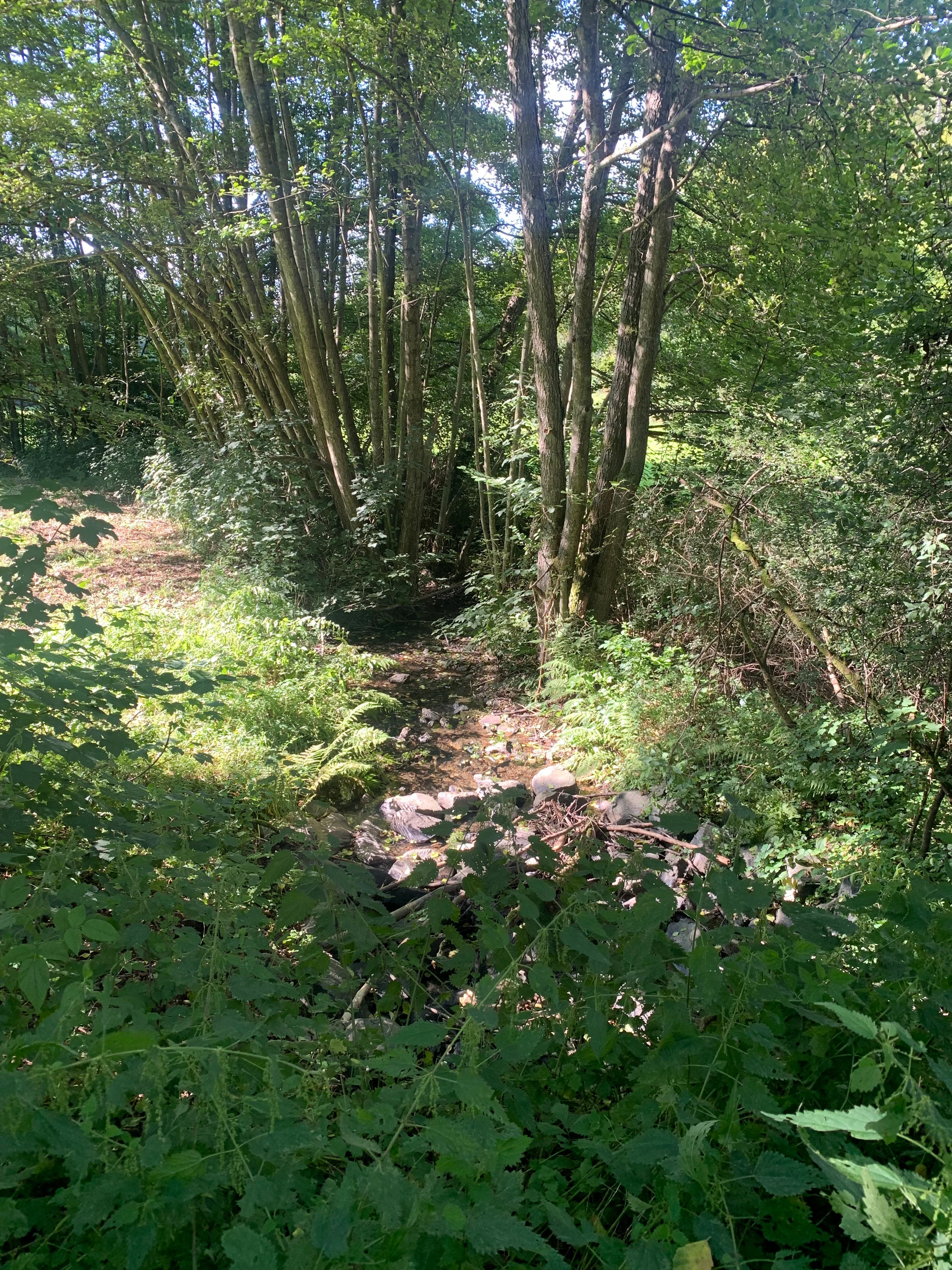
A small rocky stream bed surrounded by lush green trees, shrubs, and ferns in a wooded area.
A shaded stream winding through the dense vegetation of the Oberes Dombachtal nature reserve.

Oberes Dombachtal Nature Reserve history and protected-area timeline

The Oberes Dombachtal reserve has a relatively recent formal conservation history but a much longer landscape history shaped by traditional valley land use. Before protection, the valley supported a mixture of grazing, hay cutting, and small-scale forestry, including conifer plantations such as spruce that were established on parts of the slopes. Over time, the abandonment of hay cutting on the wetter parts of the valley led to degradation of species-rich moist meadows, a trend that became a central concern for local conservation planning.

The site was officially designated as a Hessian nature reserve (Naturschutzgebiet) on 17 February 1995, following decades during which valley grasslands and headwater streams across the Taunus suffered from agricultural intensification, drainage, and forestry conversion. The stated management goals at the time of designation were to regenerate abandoned moist meadows (Feuchtwiesen), reduce the intensity of mowing on species-rich oat-grass meadows, convert former wild food plots into permanent grassland, and gradually replace spruce stands with site-appropriate deciduous woodland.

In a broader European context, the reserve was later incorporated into the Natura 2000 network as part of the Dombachtal Fauna-Flora-Habitat area, linking it with neighboring valley reserves and headwater streams across the eastern Taunus. This integration reflected growing recognition of the Dombach valley as a coherent ecological corridor rather than a series of isolated parcels.

Oberes Dombachtal Nature Reserve landscape and geographic character

The landscape of Oberes Dombachtal is shaped by a narrow valley cut into the eastern slopes of the Sommerberg in the Taunus range. The reserve follows the upper Dombach as it flows through the valley, flanked by moderately steep forested hillslopes on one side and gently sloping meadow terraces on the other. The valley sits at the transition between the higher wooded ridges of the Taunus and the more open agricultural foothills to the east, creating a landscape pattern typical of the eastern Taunus valleys.

Topographically, the reserve is small but structurally diverse. Its lowest elevations follow the Dombach streambed, while the higher ground rises sharply along the adjacent slopes. This vertical range creates sharply differentiated habitat zones, from permanently moist streambanks to drier-wooded slopes. The result is a layered landscape where stream, floodplain woodland, wet meadows, and slope forest all lie within a short distance of one another.

Within the wider region, Oberes Dombachtal represents one of several smaller valleys that characterize the Taunus foothills. The Dombach itself continues westward beyond the reserve limits to the village of Schwickershausen, and the broader Dombachtal FFH area extends along the entire valley system. The combination of valley orientation, slope exposure, and stream hydrology gives the reserve its distinctive alternation of shaded woodland, open meadow, and exposed stream corridor.

Oberes Dombachtal Nature Reserve ecosystems, habitats, and plant life

The ecological character of Oberes Dombachtal is defined by the close interaction between flowing water, floodplain soils, and valley vegetation. The Dombach runs through the reserve in a largely natural state, with undisturbed banks and seasonal flow dynamics that create saturated soils along the valley floor. These conditions have allowed relict patches of Hainsternmieren-Erlenauwald, a specialized alder floodplain forest community, to persist along the stream margins, representing one of the more distinctive habitats within the site.

The valley floor grasslands are equally important to the reserve's ecological identity. Three main meadow types are present, each tuned to different moisture and soil conditions. Purple moor-grass meadows (Pfeifengraswiesen) occupy the more acidic and peat-influenced zones, while tall oat-grass meadows (Glatthaferwiesen) occur on better-drained sites, and marsh marigold meadows (Sumpfdotterblumenwiesen) flourish in the wettest flats where spring inundation is common. Together these meadows form a patchwork that supports a rich flora and provides breeding and feeding habitat for a wide range of invertebrates and birds.

The surrounding slopes are partly forested, with deciduous woodland communities replacing former spruce plantations. The intent of ongoing management is to shift the forest composition toward native broadleaved species suited to the local soils and microclimate. This gradual conversion connects the valley habitats with the surrounding woodland matrix and supports overall habitat continuity in the Taunus foothills.

Oberes Dombachtal Nature Reserve wildlife and species highlights

Wildlife significance at Oberes Dombachtal is closely tied to the integrity of its wet meadows, stream habitat, and floodplain woodland. The combination of standing water, saturated soils, and unmanaged vegetation creates conditions for species that are otherwise in decline across Hesse, particularly those associated with wet valley grasslands and small forest streams.

The alder floodplain woodland remnants, together with the dense moist meadows, provide breeding habitat for typical valley-adapted birds and conceal foraging opportunities for woodland species using the stream corridor. The stream itself supports the aquatic invertebrates and small fish populations typical of the upper stretches of Taunus brooks, including those that depend on shaded, oxygen-rich water and natural sediment structures.

Invertebrate diversity is a notable feature of the reserve, as the mosaic of moist meadows and semi-natural stream banks provides resources for butterflies, dragonflies, and other insects that respond strongly to habitat structure and water quality. The presence of multiple meadow types also supports varied botanical communities, which in turn sustain the herbivorous invertebrates that underpin the food chain within the valley.

Oberes Dombachtal Nature Reserve conservation status and protection priorities

Oberes Dombachtal is protected under Hessian nature conservation law as a Naturschutzgebiet and is integrated into the European Natura 2000 network through its inclusion in the Dombachtal FFH area. Its IUCN category is IV, classifying it as a Habitat/Species Management Area where active intervention is used to maintain or restore specific habitats and species rather than leaving the area untouched.

Conservation priorities for the reserve focus on reversing past degradation and reinforcing the ecological coherence of the Dombach valley. Specific objectives are the regeneration of abandoned wet meadows, the extensification of existing oat-grass meadows to restore their species richness, the conversion of former wild food plots (Wildäcker) into open grassland, and the gradual replacement of spruce stands with site-appropriate deciduous forest. These measures aim to restore ecological processes such as natural grazing pressure, seasonal flooding, and native forest succession.

The reserve's broader importance lies in its role within a cross-district conservation corridor. By linking headwater streams in the Limburg-Weilburg district with the Dombachwiesen von Riedelbach reserve in the Hochtaunuskreis and additional stream sections in the Rheingau-Taunus-Kreis, Oberes Dombachtal contributes to maintaining ecological connectivity across administrative boundaries in the eastern Taunus.

Oberes Dombachtal Nature Reserve cultural meaning and human context

The landscape of Oberes Dombachtal carries a strong imprint of historical rural land use. Many of the fields within the reserve carry names that reflect long-standing patterns of meadow, pasture, and forest use, including references to wet meadows (Sauerwiesen, dürre Wiesen), woodland parcels (Nußheck, Kirchheck), and slope locations (Am Stolzenberg, Am Heppenborn). These names reflect how local communities distinguished valley habitats in practical terms.

Traditional valley agriculture, particularly hay production and extensive grazing, played a central role in maintaining the open meadow character that gives the reserve much of its ecological value today. The pull-back of this traditional use during the twentieth century contributed directly to the abandonment and degradation of wet meadows, a problem that motivated the reserve's designation and continues to shape its management strategy.

The reserve also sits within the wider cultural landscape of Bad Camberg and the eastern Taunus, where valley villages such as Dombach and Schwickershausen have long been shaped by the relationship between settlement, watercourses, and surrounding forest. Conservation of the valley is thus both an ecological and a cultural effort, preserving a traditional landscape type whose survival is tied to active, regionally adapted land management.

Top sights and standout views in Oberes Dombachtal Nature Reserve

The reserve protects a near-natural section of the upper Dombach stream, an uncommon feature in the intensively used Taunus landscape. Along this stream corridor, fragments of Hainsternmieren alder floodplain woodland persist, representing a habitat type dependent on regular spring flooding and undisturbed soils.

The valley floor supports a striking sequence of three traditional meadow types: purple moor-grass meadows, tall oat-grass meadows, and marsh marigold meadows. Each occupies a different moisture zone, producing a fine-scale ecological mosaic within a very small area.

The reserve is also notable for its connection to the broader Dombachtal FFH area, which extends into two neighboring districts. This gives Oberes Dombachtal value as part of a continuous valley conservation corridor, linking it with the Dombachwiesen von Riedelbach reserve and additional headwater stream sites across the eastern Taunus.

Best time to visit Oberes Dombachtal Nature Reserve

Oberes Dombachtal is best experienced in late spring and early summer, when valley meadows in the Taunus foothills typically reach their richest flowering period. The marsh marigold meadows in particular are at their peak during this window, while the surrounding deciduous slopes are in fresh leaf.

Late spring also tends to coincide with elevated stream flow from snowmelt and seasonal rainfall, which supports more visible floodplain dynamics along the Dombach. Visiting during the cooler, wetter part of the year increases the chance of seeing the alder floodplain relics in their characteristic saturated state.

Summer visits remain worthwhile for general appreciation of the meadow mosaic and woodland canopy, though late summer can mark the beginning of hay cutting on the drier meadows, which temporarily reduces visible flowering. As in any small valley reserve, weather conditions strongly affect atmosphere, with overcast, mild days offering the most immersive experience of the reserve's wetland and forest character.

Monthly climate preview

Long-term representative monthly temperature and precipitation patterns in Hessen

Oberes Dombachtal Climate Normals and Annual Temperature Rhythm

Oberes Dombachtal records measured monthly temperature and precipitation normals based on historical coordinate data from 1991 to 2020. Examining the complete twelve-month sequence reveals detailed variations in average minimum and maximum thresholds across the protected landscape.
Annual mean9 °C
0 °C19 °C
Jan
Feb
Mar
Apr
May12°
Jun16°
Jul19°
Aug18°
Sep14°
Oct
Nov
Dec
Warmest month
July

18.5 °C

Coolest month
January

-0.4 °C

Wettest month
December

2.5 mm/day

Driest month
April

1.6 mm/day

Park location guide

Geography guide, regional context, and park location map for Oberes Dombachtal Nature Reserve

Oberes Dombachtal Nature Reserve park geography, regions, and map view in Germany

Understand where Oberes Dombachtal Nature Reserve sits in Germany through a broader geographic reading of the surrounding landscape, nearby location context, and its mapped position within the national park landscape.

How Oberes Dombachtal Nature Reserve fits into Germany

Germany is a federal republic in Western and Central Europe with a population of over 83 million across sixteen constituent states. It is Europe's largest economy by nominal GDP and a major global exporter and importer. The capital is Berlin, and the country borders Denmark, Poland, Czech Republic, Austria, Switzerland, France, Luxembourg, Belgium, and the Netherlands.

Wider geography shaping Oberes Dombachtal Nature Reserve in Germany

Germany is located in Western and Central Europe, spanning 357,022 km². It borders Denmark to the north, Poland and the Czech Republic to the east, Austria and Switzerland to the south, and France, Luxembourg, Belgium, and the Netherlands to the west. The country has coastlines on the Baltic Sea and North Sea to the north, with the Alps located in the southern region.

Map view of Oberes Dombachtal Nature Reserve

Use this park location map to pinpoint Oberes Dombachtal Nature Reserve in Germany, understand its exact geographic position, and read its mapped placement within the surrounding landscape more clearly.

Pigeon | © OpenStreetMap contributors

Location context for Oberes Dombachtal Nature Reserve

Hessen

Visual reference of protected valley habitats, headwater streams, and moist meadows.

Oberes Dombachtal Landscape and Scenery Photography

Visual documentation of Oberes Dombachtal reveals the distinctive terrain of the eastern Taunus foothills, including headwater streams, alder floodplain woodland, and traditional wet meadows. Examining these protected habitats clarifies the ecological structure of the valley corridor and its surrounding forested slopes.

A small rocky stream bed surrounded by lush green trees, shrubs, and ferns in a wooded area.

Park atlas

Compare adjacent Taunus nature reserves and connected valley ecosystems.

Explore Parks Near Oberes Dombachtal and Surrounding Protected Valley Landscapes

Browse protected areas situated near Oberes Dombachtal to examine similar headwater streams and wet meadows across the eastern foothills. Comparing adjacent valley reserves provides broader geographic context for the regional conservation network.
A watercolor painting of a rolling landscape featuring open fields in the foreground, distant hills, and a cluster of pine and deciduous trees on the right side.
Nature reserveHochtaunuskreis
About 2.5 km away#1 closest

East

Riedelbacher Heide Nature Reserve: Geographic Map and Landscape Analysis of the Taunus

A preserved open heathland within the forested Hintertaunus uplands

Riedelbacher Heide offers a focused look at an 8.4 hectare nature reserve located on the high plateau of the eastern Hintertaunus. This area provides valuable insight into the ecological and cultural history of the Taunus, where historical grazing practices shaped a distinctive mosaic of open, sun-exposed vegetation. The reserve serves as a critical example of traditional land management in a predominantly forested low-mountain geography.

Area
0.084 km²
Established
1969
Watercolor painting depicting a landscape with rolling hills in the background and trees in autumn colors in the midground.
Nature reserveHochtaunuskreis
About 6.1 km away#2 closest

Southeast

Saubach und Niedgesbach bei Schmitten Nature Reserve: High Taunus Landscape Geography

Mapped protected valleys in the Hochtaunuskreis region.

This nature reserve protects the parallel stream valleys of the Saubach and Niedgesbach near the village of Schmitten. The site is a significant example of High Taunus upland ecology, where abandoned pastoral land has fostered unique plant diversity. It remains a key focal point for understanding the transition of cultural landscapes into protected wild habitats within the Hochtaunuskreis.

Area
0.58 km²
Established
1995
A soft, impressionistic watercolor painting of a meadow with wildflowers in the foreground, rolling hills and trees in the midground, and a faint mountain range in the background.
Nature reserveHochtaunuskreis
About 9.9 km away#3 closest

Southeast

Reifenberger Wiesen Nature Reserve: Geographic Profile and Protected Meadow Boundaries

High Taunus mountain meadows within the Hochtaunuskreis region.

Located in the High Taunus mountains, Reifenberger Wiesen provides a concentrated example of mountain hillside meadows. This nature reserve features specialized nutrient-poor grasslands that host diverse botanical communities, supported by its distinct north-facing slope geography and proximity to the headwaters of the Weil river, forming a critical ecological link in the Hessian landscape.

Area
0.234 km²
Established
1983
A watercolor illustration of a serene valley landscape with a small winding stream running through grassy meadows, bordered by trees in the distance.
Nature reserveHesse
About 11 km away#4 closest

South

Dattenbachtal zwischen Kröftel und Vockenhausen Nature Reserve in Hesse, Germany

Stream valley and protected riparian landscape mapping

This nature reserve protects a vital section of the Dattenbach stream valley between the villages of Kröftel and Vockenhausen. Spanning cross-district boundaries in the Taunus foothills, the site is defined by its two-parcel structure and its role in preserving headwater stream habitats within the larger Hessian landscape.

Area
0.909 km²
Established
1993
A soft watercolor painting depicting rolling green hills and a forested landscape under a pale, sunrise-hued sky.
Nature reserveHessen
About 14 km away#5 closest

South

Rossert - Hainkopf - Dachsbau Nature Reserve: Geography and Protected Taunus Forest Landscapes

A preserved ridge system in the Hessen region of Germany

The Rossert - Hainkopf - Dachsbau nature reserve represents a compact but ecologically vital ridge system in the Taunus foothills. Spanning over 120 hectares of mixed forest, this protected area preserves the transition between woodland and open meadow while securing the headwaters of the Wellbach stream within its geographic boundaries.

Area
1.19 km²
Established
1977
IUCN
IV
Nature reserveHessen
About 14 km away#6 closest

South

Krebsbachtal bei Ruppertshain: Protected Stream Valley and Conservation Geography

Nature reserve and FFH site in the Hessian Taunus

Located in the western foothills of the Taunus, Krebsbachtal bei Ruppertshain is a protected nature reserve and Natura 2000 site. It features a linear valley landscape defined by the Fischbach stream corridor and dense mixed deciduous forest. The reserve plays a crucial role in maintaining regional ecological continuity within the Rhine-Main area, providing a distinct geographic boundary near the Rossert massif.

Area
0.845 km²
Established
1992
IUCN
IV
Relief
Upland
A horizontal watercolor painting showing a soft, impressionistic landscape with rolling green hills and patches of forest under a pale, muted sky.
Nature reserveHessen
About 15 km away#7 closest

Southeast

Burghain Falkenstein Nature Reserve: Protected Woodland Map and Regional Geography

A forest enclave in the Taunus uplands of Hessen, Germany

Burghain Falkenstein stands as a prominent nature reserve and Natura 2000 site located on the slopes of the Burgberg. This compact protected area features a mosaic of beech and ravine forests, providing a rare green massif amidst the urban sprawl of the Taunus foothills. The reserve documents a complex history where natural woodland succession intersects with medieval fortification remains, offering a concentrated study of regional forest geography near Frankfurt am Main.

Area
0.363 km²
Established
1966
IUCN
IV
Relief
Mountain
A watercolor illustration of a gentle valley landscape with rolling green hills, scattered trees, and a small stream meandering through the center.
Nature reserveHesse
About 16 km away#8 closest

East

Röllbachtal bei Usingen: A Protected Stream Valley and Nature Reserve in Hesse

Mapping riparian restoration and low mountain valley habitats

Röllbachtal bei Usingen represents a key protected landscape in the Eastern Hintertaunus of Germany. The nature reserve manages a narrow stream corridor characterized by alder and ash riparian forests, wet meadows, and tall herb floodplain vegetation. This area provides a clear view into the successful restoration of valley habitats and the broader network of protected natural spaces across the Hochtaunuskreis region.

Area
0.739 km²
Established
1999
Relief
Upland
Climate
Temperate

Common questions about visiting, size, designation, and location context for Oberes Dombachtal Nature Reserve

Oberes Dombachtal Nature Reserve FAQs for park facts, access, geography, and protected area context

Find quick answers about Oberes Dombachtal Nature Reserve, including protected-area facts, park geography, trail and visitor context, and how the park fits into its surrounding country and regional landscape.
MoriAtlas Explorer

Continue Your Protected Areas Search Across the Global Atlas

Deepen your exploration by continuing the structured search for national parks and protected areas worldwide. Utilize the comprehensive filtering capabilities to compare different conservation landscapes and refine your understanding of global park geography. Discover more about the distribution and characteristics of protected natural areas.

Global natural geography