
Mori Atlas logo
Nature reserveRöllbachtal bei Usingen

Examining the ecological restoration of streamside woodlands and wet meadow valley terrain

Röllbachtal bei Usingen: A Protected Nature Reserve within the Eastern Hintertaunus Landscape

The Röllbachtal bei Usingen nature reserve encompasses a compact valley system in the Hochtaunuskreis district of Hesse. This protected area preserves a diverse sequence of wet meadows and tall herb communities along a low mountain stream corridor. The site represents a significant example of active habitat management, where spruce plantations were converted into native alder and ash riparian woodlands to restore the natural hydrological character of the valley floor.

nature reserveNaturschutzgebietwet meadowtall-herb floodplainriparian woodlandalder-ash forest
A flat-style digital illustration showing a mountain valley with a river winding through the center, pine trees in the foreground, and a small waterfall on the right.

Röllbachtal bei Usingen

Nature reserve

Park overview

Structured park overview, official facts, and landscape profile for Röllbachtal bei Usingen

Röllbachtal bei Usingen park facts, protected area profile, and essential visitor context

Review the core facts for Röllbachtal bei Usingen, including designation, size, terrain, visitor scale, habitats, and operating context in one park-focused overview.

About Röllbachtal bei Usingen

Röllbachtal bei Usingen is a small but ecologically focused nature reserve in the eastern Taunus foothills, protecting the narrow valley carved by the Röllbach stream as it drops from the uplands near Wehrheim down toward the town of Usingen. Although the stream is only about 2.4 kilometers long, the protected area around its course covers roughly 73.93 hectares of valley bottom and adjacent slopes.

Geographically, the reserve lies within the Usinger Becken, a basin-like landscape within the broader Eastern Hintertaunus range of the Taunus. This part of the Taunus is characterized by gentle relief, mixed woodland, agricultural meadows, and a network of small brooks that feed into the Usa river system, which ultimately drains via the Wetter, Nidda, and Main rivers into the Rhine and the North Sea. The Röllbach is a right-bank tributary of the Usa, joining it just east of Usingen.

The ecological identity of the valley is defined by moisture. Wet meadows (Feuchtwiesen) and moist tall-herb floodplain communities (Hochstaudenfluren) line much of the stream, giving the reserve its characteristic herb-rich, moist appearance and supporting the insect, amphibian, and plant communities typical of such valley habitats. The valley runs from open meadow near its source north of Wehrheim, through a wedge of woodland on the western flank of the Binzelberg, and along the forest edge past the Röllbachhof before opening toward Usingen.

A key part of the reserve's modern identity is a habitat conversion effort. Until the summer of 2004, the upper course of the Röllbach flowed through a spruce-dominated forest, a condition historically common across the Taunus but ecologically at odds with the valley's wet, base-rich soils. The spruce stands were removed and replaced with locally appropriate alder and ash, re-establishing a more natural riparian woodland pattern that better reflects the site's hydrology and light conditions.

Formally designated on 11 August 1999, Röllbachtal bei Usingen is one of many small nature reserves in the Hochtaunuskreis that collectively safeguard the region's valley meadows, brook corridors, and species-rich grassland habitats in the densely populated Rhine-Main region.

Quick facts and research context for Röllbachtal bei Usingen

Röllbachtal bei Usingen is a designated nature reserve of roughly 74 hectares in the Hochtaunuskreis, Hesse, in central-western Germany. It sits within the Eastern Hintertaunus sub-range of the Taunus mountains, within the broader Usinger Becken landscape zone, and lies in the catchment of the Usa river, itself part of the Wetter, Nidda, Main, and ultimately Rhine system draining to the North Sea.

The protected area follows the course of the Röllbach, a roughly 2.4 kilometer right-bank tributary of the Usa that rises near Wehrheim at about 350 meters above sea level and enters the Usa near Usingen at around 266 meters. The valley is shaped by wet meadows and moist tall-herb vegetation, and its protected status dates to 11 August 1999.

Protection and recognition

Explore documented terrestrial conservation scope and official designation facts

Röllbachtal bei Usingen Protection Status and Recognition Data

Röllbachtal bei Usingen maintains a documented terrestrial protection scope without imported international recognition sources. Structured records assemble verified designation data and management parameters for geographic analysis.

Protection details

Protection scope
Terrestrial
Transboundary protection
No
Park context

Deeper park guide and search-rich context for Röllbachtal bei Usingen

Röllbachtal bei Usingen history, landscape, wildlife, and travel context

Explore Röllbachtal bei Usingen through its history, landscape character, ecosystems, wildlife, conservation priorities, cultural context, and seasonal travel timing in a structured park guide built for atlas discovery and search intent.

Why Röllbachtal bei Usingen stands out

Röllbachtal bei Usingen is best known as a compact example of a wet low-mountain valley reserve where wet meadows, tall-herb floodplain vegetation, and a small meandering brook define the landscape. Its most distinctive ecological story is the deliberate conversion, completed by summer 2004, of the upper valley's spruce plantation into a planted stand of alder and ash to better match the site's hydrological and ecological character. Because of its modest size and its position between Wehrheim and Usingen, the reserve also serves as a locally significant piece of the larger mosaic of protected valley habitats and species-rich meadows that characterize the Eastern Hintertaunus and the Hochtaunuskreis protected-area network.
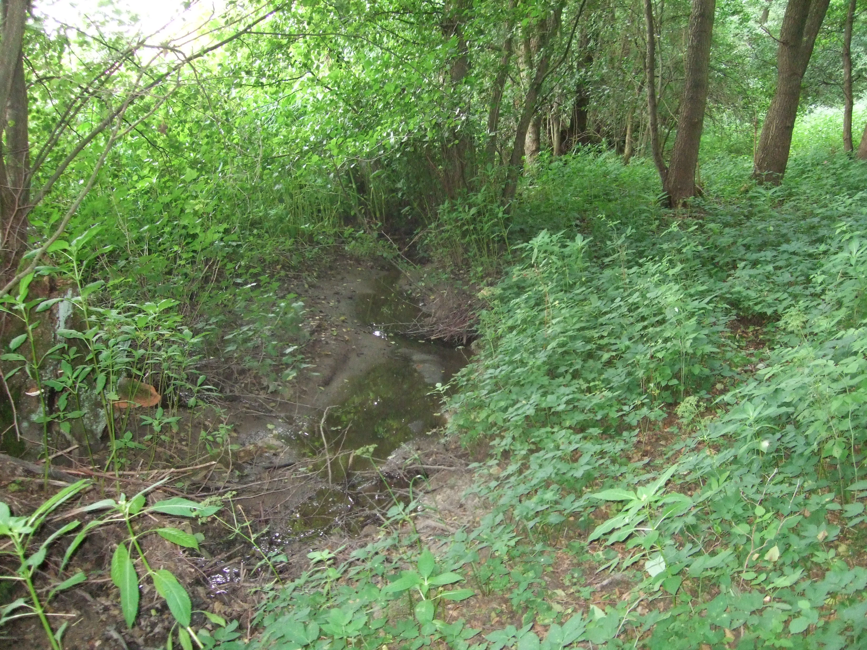
A narrow stream flowing through a dense, green forest with lush vegetation along the banks.
The Röllbach stream flowing through a shaded valley near Usingen.

Röllbachtal bei Usingen history and protected-area timeline

The protected status of Röllbachtal bei Usingen dates to 11 August 1999, when the approximately 73.93-hectare valley was formally placed under protection as a Naturschutzgebiet within the Hochtaunuskreis of Hesse. The designation recognized the valley's existing ecological value, particularly the presence of wet meadows and moist tall-herb floodplain vegetation along the Röllbach.

Subsequent management action reshaped the reserve itself. Until summer 2004, the upper section of the Röllbach flowed through an area dominated by spruce, a tree species widely planted across the Taunus during earlier forestry eras but poorly suited to the valley's moist, base-rich valley-bottom conditions. As part of active habitat restoration, the spruce was removed and replaced with alder and ash, species more typical of natural riparian woodland in this kind of wet low-mountain valley.

The reserve sits within a wider landscape context shaped by long-established settlement and land use. Wehrheim and Usingen, the two communities bracketing the valley, represent centuries of agricultural use of the surrounding Taunus slopes, and the wet meadows of the Röllbachtal reflect traditional grassland management in valley bottoms that would otherwise be easiest to drain or afforest. Its modern protected status reflects a shift toward valuing such valley habitats for the biodiversity, hydrology, and landscape character they sustain.

Röllbachtal bei Usingen landscape and geographic character

Röllbachtal bei Usingen occupies a narrow, north-south oriented valley in the Eastern Hintertaunus, with a relatively gentle relief typical of this part of the Taunus range. The Röllbach descends roughly 84 meters over its 2.4-kilometer course, from about 350 meters above sea level near Wehrheim to about 266 meters above sea level where it meets the Usa near Usingen.

The valley's shape is defined by several recognizable landscape elements. Near its source, the Röllbach begins in an open meadow north of Wehrheim. Within about 200 meters of its origin it enters a wooded area, where the hillside of the Binzelberg rises on its western side. The stream then travels northward along the forest edge, passing the Röllbachhof before opening again as it approaches Usingen. South of the Röllbachhof, the Röllbach receives a small additional tributary, the Kittelbach, on its right side.

This combination of open wet valley bottom, gentle wooded slopes, and a small forested middle section gives the protected area a clearly layered structure: open meadow upstream, a wooded narrowing around the Binzelberg, and a more open meadow-and-tall-herb character on the lower valley floor before the stream enters the Usa catchment. The valley reads visually as a green, herb-rich break in the surrounding agricultural and forest landscape of the Usinger Becken.

Röllbachtal bei Usingen ecosystems, habitats, and plant life

The ecological character of the nature reserve is dominated by moisture-adapted habitats. Wet meadows (Feuchtwiesen) and moist tall-herb floodplain communities (Hochstaudenfluren) form the backbone of the valley's vegetation, supporting the kinds of herbaceous diversity typical of well-watered low-mountain valley floors in the Taunus.

The riparian woodland component has been deliberately reshaped to align with the site's ecological potential. Where a spruce plantation once occupied the upper valley, a planted stand of alder and ash now occupies comparable ground, conforming better to the forest community expected on moist valley-bottom soils. This shift toward naturally appropriate tree species supports both the hydrological stability of the stream banks and the associated understory and invertebrate communities.

Within the broader landscape, the reserve functions as a refuge for valley-bottom species that depend on uninterrupted meadow-and-stream corridors. Its position within the Usinger Becken links it ecologically to the wider network of protected valley habitats across the Hochtaunuskreis, where similar small reserves protect comparable chains of brooks, wet meadows, and species-rich grasslands across the Eastern Hintertaunus.

Röllbachtal bei Usingen conservation status and protection priorities

The conservation significance of Röllbachtal bei Usingen lies in its role as a protected wet valley within an otherwise heavily used low-mountain landscape near the southern edge of the Taunus, close to the densely populated Rhine-Main region. By safeguarding roughly 73.93 hectares of wet meadow, tall-herb floodplain vegetation, and a small brook corridor, the reserve preserves habitat types that have become increasingly rare in central Germany due to drainage, agricultural intensification, and conifer afforestation.

The reserve's formal protection, in place since 11 August 1999, underpins a deliberate habitat restoration effort. The 2004 conversion of the upper valley from spruce to alder and ash is the reserve's most visible conservation action, addressing a long-standing mismatch between historical tree cover and the wet valley-bottom conditions of the site. This kind of correction is broadly representative of modern Taunus-nature-reserve practice, where restoring site-natural woodland composition is a key strategy for maintaining habitat quality.

More broadly, the reserve is one of a dense cluster of Naturschutzgebiete within the Hochtaunuskreis, contributing to a local network that maintains functional ecological connectivity for valley-bottom species in the Eastern Hintertaunus.

Röllbachtal bei Usingen cultural meaning and human context

The valley sits within a culturally well-rooted Taunus landscape, bracketed by the two communities of Wehrheim and Usingen. The presence of the Röllbachhof as a named feature along the valley's course reflects the long-standing agricultural character of the area, where small valley farms historically worked the wet meadows that the reserve now protects.

The wider Taunus region has a long tradition of low-intensity meadow use, transhumance, and small-scale valley farming, and the wet valley floors like the Röllbachtal historically functioned as important hay and pasture grounds. Their modern protection reflects both the ecological value of these habitats and an evolving regional identity that recognizes the cultural landscape significance of even small land parcels.

Top sights and standout views in Röllbachtal bei Usingen

The reserve's standout features are its compact but ecologically expressive combination of wet meadows, tall-herb floodplain vegetation, a meandering low-mountain brook, and a restored alder-ash riparian woodland. The deliberate reset from spruce to broadleaf woodland along the upper Röllbach is a clear, locally visible conservation success story.

Within the Hochtaunuskreis network of protected areas, the Röllbachtal represents the kind of small, function-focused valley reserve that defines the modern Eastern Hintertaunus protected-area mosaic: a narrow stream corridor delivering outsized biodiversity value in a densely populated region.

Best time to visit Röllbachtal bei Usingen

As a small low-mountain valley reserve dominated by meadows and tall-herb vegetation, Röllbachtal bei Usingen is most atmospherically appealing in late spring and summer, when the wet meadows and tall-herb floodplain communities are in full growth and the valley reads as a vivid ribbon of green against the surrounding woodland and fields. Late spring typically brings the most diverse herb flowering in such valley habitats, while high summer emphasizes the lush, moisture-rich character of the tall-herb vegetation.

Cooler seasons offers a quieter, more muted experience, with the restored alder-ash woodland along the upper valley becoming a more dominant visual element once the meadow vegetation has died back. Milder, drier conditions in early autumn are also workable for visitors who prefer a less verdant, more open landscape profile in a low-mountain valley setting.

Monthly climate preview

Long-term representative point measurements of monthly temperature and precipitation

Röllbachtal bei Usingen Climate Normals and Annual Temperature Rhythm

Historical climate data for Röllbachtal bei Usingen reveals a wide annual temperature spread alongside steady daily precipitation rates across all twelve recorded months. Analyzing these monthly baseline patterns provides deeper geographic context for the protected area without relying on live forecasts.
Annual mean9 °C
-1 °C19 °C
Jan-1°
Feb
Mar
Apr
May13°
Jun16°
Jul19°
Aug19°
Sep14°
Oct
Nov
Dec
Warmest month
July

18.8 °C

Coolest month
January

-0.6 °C

Wettest month
July

2.5 mm/day

Driest month
April

1.6 mm/day

Park location guide

Geography guide, regional context, and park location map for Röllbachtal bei Usingen

Röllbachtal bei Usingen park geography, regions, and map view in Germany

Understand where Röllbachtal bei Usingen sits in Germany through a broader geographic reading of the surrounding landscape, nearby location context, and its mapped position within the national park landscape.

How Röllbachtal bei Usingen fits into Germany

Germany is a federal republic in Western and Central Europe with a population of over 83 million across sixteen constituent states. It is Europe's largest economy by nominal GDP and a major global exporter and importer. The capital is Berlin, and the country borders Denmark, Poland, Czech Republic, Austria, Switzerland, France, Luxembourg, Belgium, and the Netherlands.

Wider geography shaping Röllbachtal bei Usingen in Germany

Germany is located in Western and Central Europe, spanning 357,022 km². It borders Denmark to the north, Poland and the Czech Republic to the east, Austria and Switzerland to the south, and France, Luxembourg, Belgium, and the Netherlands to the west. The country has coastlines on the Baltic Sea and North Sea to the north, with the Alps located in the southern region.

Map view of Röllbachtal bei Usingen

Use this park location map to pinpoint Röllbachtal bei Usingen in Germany, understand its exact geographic position, and read its mapped placement within the surrounding landscape more clearly.

Pigeon | © OpenStreetMap contributors

Location context for Röllbachtal bei Usingen

Hesse

Visual reference for wet meadows, riparian woodland, and low-mountain stream scenery

Röllbachtal bei Usingen Photos and Protected Valley Landscapes

Visual records capture the low-mountain valley topography, meandering stream channels, and restored broadleaf woodlands of Röllbachtal bei Usingen. Photographic documentation reveals the underlying terrain and wet meadow habitats that define the character of this protected stream corridor.

A narrow stream flowing through a dense, green forest with lush vegetation along the banks.

Park atlas

Compare nearby valley reserves and connected protected landscapes across the Taunus range.

Explore Other Parks Near Röllbachtal bei Usingen and Protected Areas in the Region

Continue browsing adjacent nature reserves and stream corridors to evaluate similar low mountain habitats in the Hochtaunuskreis network. Comparing these surrounding protected areas reveals broader ecological patterns across the Eastern Hintertaunus region.
A watercolor painting showing rolling green meadows, trees, and soft distant hills against a white background.
Nature reserveHessen
About 9.2 km away#1 closest

South

Kirdorfer Feld bei Bad Homburg: Protected Cultural Landscape and Meadow Reserve Map

Nature reserve and Natura 2000 protected land in Hessen

Kirdorfer Feld bei Bad Homburg serves as a prime example of an intact agricultural cultural landscape, defined by its traditional Streuobstwiesen orchards, damp meadow corridors, and spring-fed wetlands. This site acts as a key ecological anchor within the Taunus foothills, showcasing a unique interplay between managed farmland and protected botanical communities. Learn about the geographic composition of this designated Natura 2000 site.

Area
1.6 km²
Established
1996
Relief
Lowland
Scope
Terrestrial
Protected areaGermany
About 9.5 km away#2 closest

Northeast

Magertriften von Ober-Mörlen und Ostheim Protected Area Geography and Map

A vital nutrient-poor grassland refuge in Hesse, Germany

Located in the Wetteraukreis district, the Magertriften von Ober-Mörlen und Ostheim protected area preserves a rare, species-rich grassland habitat on base-rich soils. This 77-hectare reserve, integrated into the Natura 2000 network, offers a stark contrast between its preserved dry-grassland ecosystems and the surrounding agricultural and industrial transport landscape of central Germany.

Area
0.775 km²
Established
1990
Relief
Lowland
Scope
Terrestrial
Watercolor painting depicting a landscape with rolling hills in the background and trees in autumn colors in the midground.
Nature reserveHochtaunuskreis
About 11 km away#3 closest

Southwest

Saubach und Niedgesbach bei Schmitten Nature Reserve: High Taunus Landscape Geography

Mapped protected valleys in the Hochtaunuskreis region.

This nature reserve protects the parallel stream valleys of the Saubach and Niedgesbach near the village of Schmitten. The site is a significant example of High Taunus upland ecology, where abandoned pastoral land has fostered unique plant diversity. It remains a key focal point for understanding the transition of cultural landscapes into protected wild habitats within the Hochtaunuskreis.

Area
0.58 km²
Established
1995
A watercolor painting of a rolling landscape featuring open fields in the foreground, distant hills, and a cluster of pine and deciduous trees on the right side.
Nature reserveHochtaunuskreis
About 13 km away#4 closest

West

Riedelbacher Heide Nature Reserve: Geographic Map and Landscape Analysis of the Taunus

A preserved open heathland within the forested Hintertaunus uplands

Riedelbacher Heide offers a focused look at an 8.4 hectare nature reserve located on the high plateau of the eastern Hintertaunus. This area provides valuable insight into the ecological and cultural history of the Taunus, where historical grazing practices shaped a distinctive mosaic of open, sun-exposed vegetation. The reserve serves as a critical example of traditional land management in a predominantly forested low-mountain geography.

Area
0.084 km²
Established
1969
A soft, impressionistic watercolor painting of a meadow with wildflowers in the foreground, rolling hills and trees in the midground, and a faint mountain range in the background.
Nature reserveHochtaunuskreis
About 14 km away#5 closest

Southwest

Reifenberger Wiesen Nature Reserve: Geographic Profile and Protected Meadow Boundaries

High Taunus mountain meadows within the Hochtaunuskreis region.

Located in the High Taunus mountains, Reifenberger Wiesen provides a concentrated example of mountain hillside meadows. This nature reserve features specialized nutrient-poor grasslands that host diverse botanical communities, supported by its distinct north-facing slope geography and proximity to the headwaters of the Weil river, forming a critical ecological link in the Hessian landscape.

Area
0.234 km²
Established
1983
A watercolor painting showing a soft, peaceful landscape with green rolling hills, a small body of water in the foreground, and faint, distant mountains under a pale sky.
Nature reserveHesse
About 14 km away#6 closest

Northeast

Kiesgrube Laukertsberg bei Nieder-Mörlen Protected Area in Hesse, Germany

A reclaimed post-industrial nature reserve and habitat

Located in the Wetterau district of Hesse, Kiesgrube Laukertsberg bei Nieder-Mörlen represents a significant shift from industrial gravel extraction to protected ecological sanctuary. The terrain features open-ground habitats and seasonal wetlands that support sensitive species, illustrating how landscape management can prioritize biodiversity. Analyze the site boundaries and its role within the broader regional geography of central Germany.

Area
0.157 km²
Established
2019
IUCN
IV
Relief
Lowland
A wide watercolor painting showing a green river valley with marshy foreground, a line of trees, and rolling hills in purple and green in the background.
Nature reserveWetteraukreis
About 15 km away#7 closest

East

Salzwiesen von Wisselsheim Nature Reserve: Atlas and Regional Geography of Wetteraukreis

Protected inland salt meadows and floodplain geography in Hesse, Germany.

Salzwiesen von Wisselsheim stands as a significant protected area in the Wetteraukreis region, distinguished by rare inland salt meadows fed by natural saline springs. This reserve presents a compelling landscape defined by the River Wetter, offering deep insights into how unique hydrogeology and historical salt production have formed a specialized lowland habitat that is largely absent from other inland regions.

Area
0.23 km²
Established
1982
Relief
Lowland
Climate
Temperate
A wide watercolor illustration showing a purple mountain in the distance, a line of green trees, a body of water, and pinkish plants in the foreground on a white background.
Nature reserveWetteraukreis
About 16 km away#8 closest

Northeast

Breitwiese bei Steinfurth und Oppershofen: A Wetteraukreis Nature Reserve Profile

Examining floodplain ecology and protected wetland boundaries

This protected area in the Wetteraukreis highlights the importance of small-scale floodplain management for biodiversity. The site preserves essential wet meadow habitats, riparian edges, and river-adjacent ecosystems that provide sanctuary for specialized amphibian and bird species. It serves as an informative case study for understanding how conservation grazing and corridor protection interact within an intensive agricultural landscape.

Area
0.164 km²
Established
1990
IUCN
IV
Relief
Lowland

Common questions about visiting, size, designation, and location context for Röllbachtal bei Usingen

Röllbachtal bei Usingen FAQs for park facts, access, geography, and protected area context

Find quick answers about Röllbachtal bei Usingen, including protected-area facts, park geography, trail and visitor context, and how the park fits into its surrounding country and regional landscape.
MoriAtlas Explorer

Continue Your Protected Areas Search Across the Global Atlas

Deepen your exploration by continuing the structured search for national parks and protected areas worldwide. Utilize the comprehensive filtering capabilities to compare different conservation landscapes and refine your understanding of global park geography. Discover more about the distribution and characteristics of protected natural areas.

Global natural geography