
Mori Atlas logo
Nature reserveKirdorfer Feld bei Bad Homburg

Mapped meadows, orchard mosaics, and spring-fed corridors on the Taunus foothills

Kirdorfer Feld bei Bad Homburg: A Protected Cultural Landscape and Nature Reserve in Hessen

Kirdorfer Feld bei Bad Homburg represents a complex mosaic of species-rich meadows and traditional orchard lands situated on the transitional slopes of the Taunus mountains in Germany. This nature reserve and designated Fauna-Flora-Habitat site preserves a working agricultural landscape that has been carefully maintained over centuries. Discover the mapped boundaries of this protected area and analyze how the intersection of spring-fed streams and dry meadow soils creates a rare habitat diversity in the Hessen region.

cultural landscapewet meadowsorchard meadowsStreuobstwiesennature reservelandscape protection area
A flat-style digital illustration depicting a valley with a river, mountains, a waterfall, and surrounding forest vegetation.

Kirdorfer Feld bei Bad Homburg

Nature reserve

Park overview

Structured park overview, official facts, and landscape profile for Kirdorfer Feld bei Bad Homburg

Kirdorfer Feld bei Bad Homburg park facts, protected area profile, and essential visitor context

Review the core facts for Kirdorfer Feld bei Bad Homburg, including designation, size, terrain, visitor scale, habitats, and operating context in one park-focused overview.

About Kirdorfer Feld bei Bad Homburg

Kirdorfer Feld bei Bad Homburg is a protected cultural landscape in the Kirdorf district of Bad Homburg vor der Höhe, in the Hochtaunuskreis district of Hesse. It sits on the gently sloping terrain between the Taunus uplands and the broader Frankfurt/Rhine-Main lowlands, an area where traditional land use has produced a distinctive mix of meadows, orchards, fields, and small watercourses. The site's roughly 160 hectares combine open farmland with the structural variety of hedgerows, solitary trees, streamlets, and damp depressions that are characteristic of older central German farming landscapes.

Within this broader landscape, a core zone of about 55 hectares is formally designated as a nature reserve, focused on the wet meadow complexes and the orchard strips that border them. Around this core, a further roughly 78 hectares have been set aside as a landscape protection area, capturing additional orchard meadows, arable plots, and grassland that buffer the more strictly protected habitats. Both designations were enacted in the same 1996 decree, producing an integrated refuge that is managed less as a fenced enclosure and more as a protected working landscape.

What makes Kirdorfer Feld unusual in the region is the botanical richness of its meadows. The wet meadows, allied with the dry slopes of orchard pasture, support a wide range of plant communities that are considered of supraregional conservation importance. In recognition of this, the area has also been designated as a Fauna-Flora-Habitat site within the Natura 2000 network, integrating the site into Europe's wider framework for protecting threatened habitat types and species.

The agricultural heritage is not an incidental backdrop. Traditional practices of hay cutting, late-season grazing, and the maintenance of scattered fruit trees have been the very mechanisms that produced the habitat variation seen today. Understanding Kirdorfer Feld therefore means reading the landscape both ecologically and culturally: as a living remnant of preindustrial land use, but also as a contemporary refuge whose continued value depends on careful stewardship and continuity of traditional management.

Quick facts and research context for Kirdorfer Feld bei Bad Homburg

Kirdorfer Feld bei Bad Homburg lies in the city of Bad Homburg vor der Höhe in the Hochtaunuskreis of the German state of Hesse, on the northwestern edge of the Rhine-Main region and the eastern foothills of the Taunus. The total cultural landscape covers roughly 160 hectares, of which about 55 hectares are designated as a nature reserve and roughly 78 hectares as an adjoining landscape protection area, with the two designations together placing about 133 hectares under formal protection. The nature reserve was established by Hessian decree on 17 October 1996, applying to the wet meadows and adjacent orchard strips that form the ecological heart of the area. The wider site holds both nature reserve and Natura 2000 Fauna-Flora-Habitat status, and is regarded, in regional biodiversity assessments, as one of the more important meadow habitats in the Hochtaunuskreis.

Protection and recognition

Documented terrestrial protection history and international Natura 2000 records

Kirdorfer Feld bei Bad Homburg Protection Status and Designated Recognition

Kirdorfer Feld bei Bad Homburg holds documented terrestrial protection status established in 1996 alongside imported Natura 2000 recognition records. Structured data profiles trace the official designation history and conservation framework governing the protected landscape.

International recognition

Protection details

Protection scope
Terrestrial
Designated year
1996
Transboundary protection
No
Core area
0.55 km²
Park context

Deeper park guide and search-rich context for Kirdorfer Feld bei Bad Homburg

Kirdorfer Feld bei Bad Homburg history, landscape, wildlife, and travel context

Explore Kirdorfer Feld bei Bad Homburg through its history, landscape character, ecosystems, wildlife, conservation priorities, cultural context, and seasonal travel timing in a structured park guide built for atlas discovery and search intent.

Why Kirdorfer Feld bei Bad Homburg stands out

Kirdorfer Feld is best known for its combination of species-rich wet meadows, traditional Streuobst (orchard meadow) habitats, and small spring-fed streams on the southern edge of the Taunus. It is recognized in particular for the supraregional significance of its meadow plant communities, which are unusual in their diversity and continuity within the region. The area also stands out as a notably well-preserved historical cultural landscape. Rather than being a rewilded reserve, it has retained its character as a working agricultural mosaic, shaped by centuries of hay cutting, grazing, and orchard management, which in turn has produced the habitat structure that supports its current ecological value.
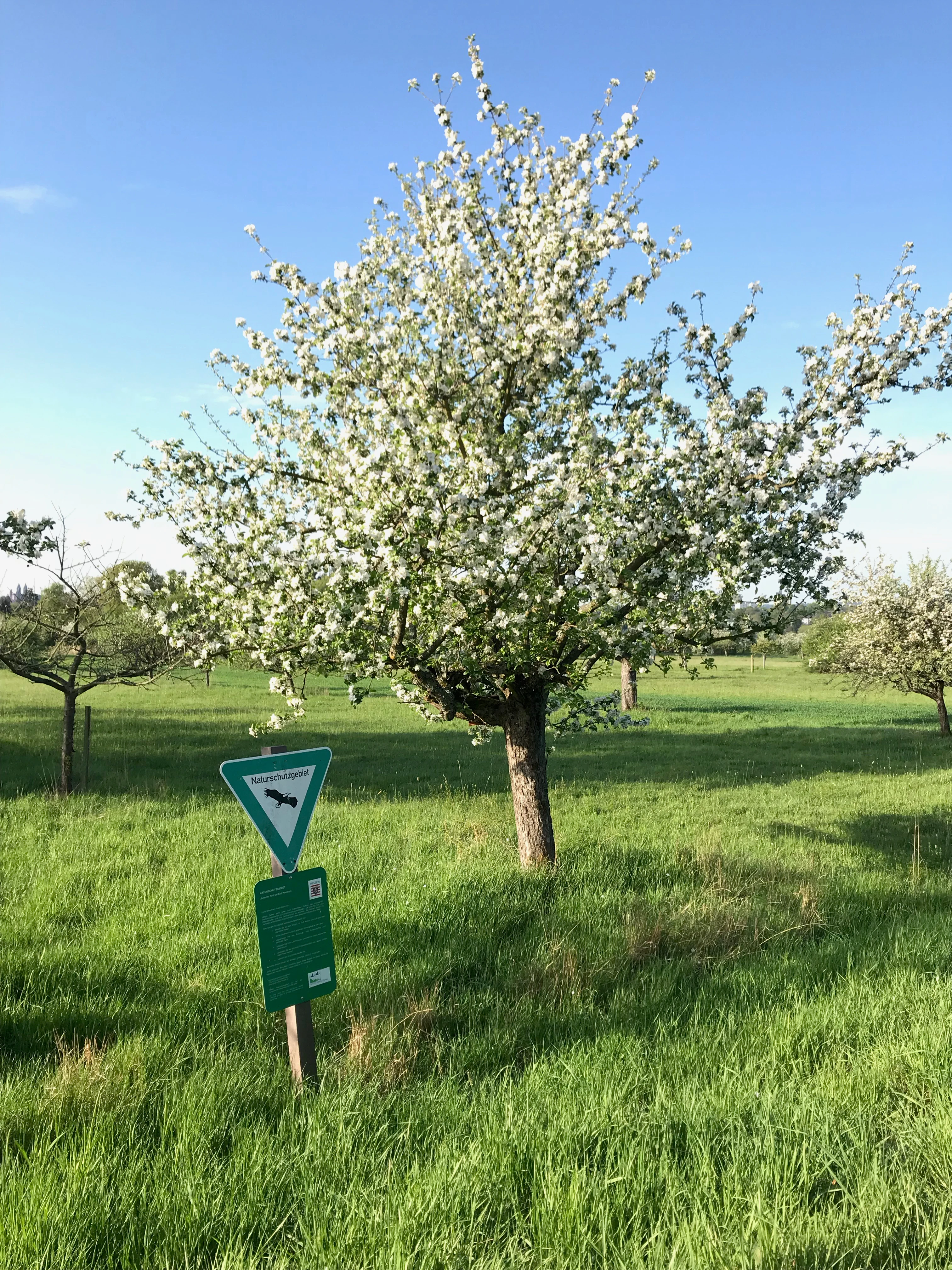
An apple tree in full white blossom stands in a lush green meadow, with a German nature reserve signage post in the foreground.
A blooming apple tree in the Kirdorfer Feld nature reserve.

Kirdorfer Feld bei Bad Homburg history and protected-area timeline

The protected status of Kirdorfer Feld bei Bad Homburg is recent, but the landscape itself is the product of long-standing agricultural use. The mosaic of wet meadows, orchard meadows, and small cultivated fields in the Kirdorf area reflects centuries of farming on the lower slopes of the Taunus, where soil conditions and water seepage favored a mixed pattern rather than large-scale arable intensification. Traditional practices such as hay-making, extensive grazing, and the planting of scattered fruit trees shaped both the visual character and the ecological structure of the area long before any formal protection was considered.

Formal recognition came in two coordinated steps in the mid-1990s. In 1995, a conservancy assessment report, prepared for the Darmstadt Regional Council by the Planungsgruppe Natur- und Umweltschutz, documented the area's ecological value and laid the groundwork for its designation. On 17 October 1996, the Hessian authorities formally declared roughly 55 hectares as a nature reserve and a further approximately 78 hectares as a landscape protection area, combining the more strictly protected core with a wider protective buffer in a single regulatory act.

By the early 2000s, the area's significance had been confirmed at the European level. A 2003 baseline survey for monitoring and management of the Fauna-Flora-Habitat site, also commissioned through the Planungsgruppe Natur- und Umweltschutz, established the data framework for ongoing protection under the EU Habitats Directive. A particularly noteworthy milestone in the site's modern history came in spring 2001, when a rare Speierling (true service tree) that had been registered as an individual natural monument had to be felled after reaching the end of its viable life at around 70 years of age.

In 2006, the Interessengemeinschaft Kirdorfer Feld was founded as a local citizens' association dedicated to the preservation of the area. The group's creation marked an important shift toward community-level stewardship, ensuring that the conservation interest mapped by ecologists in the preceding decade could be matched by sustained on-the-ground engagement from local inhabitants and visitors.

Kirdorfer Feld bei Bad Homburg landscape and geographic character

Kirdorfer Feld occupies a gently transitional zone on the eastern edge of the Taunus, where the wooded uplands give way to the more open, farmed terrain of the Rhine-Main foreland. The terrain is broadly sloping rather than dramatic, with subtle changes in elevation and aspect that determine where water collects, where meadows turn dry, and where orchard soils remain workable. This understated topography is central to the landscape's character; it is a soft, working countryside where variation is read in vegetation patterns rather than in cliff faces or ridges.

The landforms most visible in the area are shaped by water. Small streams and springs rise within the protected zone, feeding damp meadow corridors that run through the broader field system. Alongside them lie wet meadow hollows, sedge-rich patches, and spring mires, contrasted with the drier ground beneath the orchard strips where scattered fruit trees root into thinner soils. The interplay of these wet and dry zones, on what is otherwise a fairly uniform slope, gives the site much of its visual and ecological complexity.

Surrounding and interweaving with these wet features is a network of orchard meadows (Streuobstwiesen), field tracks, and small arable parcels. The result is a finely textured cultural landscape in which no single habitat dominates the view; instead, the eye moves between meadow, tree, hedge, and streamlet. From elevated vantage points within or near the area, the wider Taunus ridge can be seen in the distance, framing an otherwise lowland-feeling mosaic.

Kirdorfer Feld bei Bad Homburg ecosystems, habitats, and plant life

Ecologically, Kirdorfer Feld is defined by the richness and persistence of its meadow plant communities. The wet meadows and their drier margins support a wide range of grasses, sedges, and herbaceous flowering plants that have declined sharply in many parts of central Germany under modern intensive agriculture. Several management and assessment reports specifically emphasize that the meadow associations here are of supraregional importance, meaning that they are considered botanically valuable beyond the immediate Hochtaunuskreis area.

The habitat mosaic extends well beyond the meadows themselves. Traditional Streuobstwiesen, in which scattered fruit trees of varying age and species stand over species-rich grassland, form a second major habitat type within the protected zone. They combine the structural complexity of old trees and dead wood with the open ground flora of the meadows below, creating conditions favorable to a wide spectrum of insects, birds, and small mammals.

Running through this mosaic are small streams, springs, and seepage zones, which maintain the hydrological conditions on which the wet meadow communities depend. These water features are minor in scale but disproportionately important ecologically, supporting distinctive damp-loving vegetation along their banks and serving as dispersal corridors and watering points for wildlife. Even though Kirdorfer Feld is a relatively compact area, the close coexistence of wet, mesic, and dry habitat types gives it an unusually broad ecological footprint for its size.

Kirdorfer Feld bei Bad Homburg wildlife and species highlights

Because Kirdorfer Feld remains primarily an open meadow and orchard landscape rather than a forested reserve, its wildlife is dominated by species that depend on structured grassland, scattered trees, and small watercourses rather than closed woodland. The combination of meadow, hedge, and orchard produces important habitat for typical central European farmland species, including meadow-breeding birds, pollinators, and small mammals that thrive at the interface of open ground and woody vegetation.

The traditional orchard strips are particularly significant for wildlife. Old fruit trees, including those in the Streuobstwiesen, provide nesting cavities, perches, and foraging opportunities for a range of bird and insect species, while the dead wood and microhabitats within them support saproxylic invertebrates. Combined with the existing meadow flora, this creates resilient conditions for pollinators such as wild bees, hoverflies, and butterflies, which in turn underpin the broader food web of the site.

Along the small streams and in the wet meadow areas, amphibians and invertebrates typical of spring-fed habitats can persist, particularly where grazed or mown management keeps vegetation from becoming too rank. Although the inventory of species recorded at the site is best read in the underlying survey literature, the everyday wildlife experience of the area is characterized by the steady presence of meadow and orchard fauna rather than by any single charismatic species; it is a quiet, varied landscape in which the abundance and continuity of common species is itself the conservation achievement.

Kirdorfer Feld bei Bad Homburg conservation status and protection priorities

Kirdorfer Feld is locally, regionally, and internationally significant from a conservation standpoint. At the local Hessian level, it carries a nature reserve designation for its wet meadows and orchard meadows, complemented by an adjoining landscape protection area that secures a broader buffer of cultural land use. Together, these two designations place roughly 133 hectares under a coherent protection framework, established through a single 1996 regulatory act.

More broadly, the meadow communities within the site have been assessed to be of supraregional botanical significance. This assessment, rather than any single species count, is the core reason for its higher-level recognition, and it explains why the area was added to the European Natura 2000 network as a Fauna-Flora-Habitat site, listed under the code 5717-301. This places the conservation of the site within the framework of the EU Habitats Directive, with corresponding obligations for monitoring, management planning, and reporting.

Conservation here is also explicitly a question of cultural practice. The site's ecological value is inseparable from the maintenance of traditional land uses such as late hay-making, extensive grazing, and the continuing management of scattered fruit trees. The Interessengemeinschaft Kirdorfer Feld, founded in 2006, reflects an awareness that the long-term survival of the site depends not only on legal protection but also on sustained local stewardship and active management of its semi-natural habitats.

Kirdorfer Feld bei Bad Homburg cultural meaning and human context

Kirdorfer Feld sits in the Kirdorf district of Bad Homburg vor der Höhe and is part of the wider historical landscape of the eastern Taunus foreland, where farming patterns established over centuries still visibly shape the land. The combination of orchard meadows (Streuobstwiesen), hay meadows, small cultivated fields, and spring-fed areas is typical of the older mixed agricultural systems that once characterized much of Hesse; their survival here, in an unusually intact form near a growing urban center, gives the area a particular cultural resonance.

Local engagement with the site has been part of its identity since the 1990s conservation planning process and was reinforced by the founding of the Interessengemeinschaft Kirdorfer Feld in 2006. The association represents the local community's recognition that the landscape is not only an ecological asset but also a cultural one, and that its preservation depends on sustaining the bond between the area and the people of Kirdorf and Bad Homburg.

Top sights and standout views in Kirdorfer Feld bei Bad Homburg

An integrated nature reserve and landscape protection area in a single working agricultural setting; meadow communities of supraregional botanical importance; recognition within the European Natura 2000 network as a Fauna-Flora-Habitat site; a rich mosaic of wet meadows, orchard meadows (Streuobstwiesen), small streams, and spring habitats; and a long-running local stewardship effort through the Interessengemeinschaft Kirdorfer Feld.

Best time to visit Kirdorfer Feld bei Bad Homburg

Because Kirdorfer Feld is best appreciated as a flowering meadow and orchard landscape, late spring through mid-summer is generally the most rewarding period for a visit, when the wet meadows are at their richest and the surrounding orchards are in full leaf. Earlier in spring, the orchard blossom offers a different visual emphasis, while autumn draws attention to the fruit harvest and the structural color of the mature trees. Winter visits tend to be quieter and more skeletal, but allow a clearer reading of the underlying field, hedge, and stream pattern. As a continually worked agricultural area, the site does not have a formal high or low season in the way a remote national park might; visitors tend to come most for ecological interest and quiet walking rather than for dramatic seasonal events.

Monthly climate preview

Long-term temperature ranges and precipitation patterns across representative coordinates

Kirdorfer Feld bei Bad Homburg Climate Normals and Monthly Weather Records

Historical data records mean temperatures spanning from negative values to over eighteen degrees Celsius alongside consistent monthly precipitation rates across the representative coordinate. Reviewing the complete twelve-month profile provides deeper insight into long-term meteorological trends and seasonal variations.
Annual mean9 °C
-1 °C19 °C
Jan-1°
Feb
Mar
Apr
May13°
Jun16°
Jul19°
Aug19°
Sep14°
Oct
Nov
Dec
Warmest month
July

18.8 °C

Coolest month
January

-0.6 °C

Wettest month
July

2.5 mm/day

Driest month
April

1.6 mm/day

Park location guide

Geography guide, regional context, and park location map for Kirdorfer Feld bei Bad Homburg

Kirdorfer Feld bei Bad Homburg park geography, regions, and map view in Germany

Understand where Kirdorfer Feld bei Bad Homburg sits in Germany through a broader geographic reading of the surrounding landscape, nearby location context, and its mapped position within the national park landscape.

How Kirdorfer Feld bei Bad Homburg fits into Germany

Germany is a federal republic in Western and Central Europe with a population of over 83 million across sixteen constituent states. It is Europe's largest economy by nominal GDP and a major global exporter and importer. The capital is Berlin, and the country borders Denmark, Poland, Czech Republic, Austria, Switzerland, France, Luxembourg, Belgium, and the Netherlands.

Wider geography shaping Kirdorfer Feld bei Bad Homburg in Germany

Germany is located in Western and Central Europe, spanning 357,022 km². It borders Denmark to the north, Poland and the Czech Republic to the east, Austria and Switzerland to the south, and France, Luxembourg, Belgium, and the Netherlands to the west. The country has coastlines on the Baltic Sea and North Sea to the north, with the Alps located in the southern region.

Map view of Kirdorfer Feld bei Bad Homburg

Use this park location map to pinpoint Kirdorfer Feld bei Bad Homburg in Germany, understand its exact geographic position, and read its mapped placement within the surrounding landscape more clearly.

Pigeon | © OpenStreetMap contributors

Location context for Kirdorfer Feld bei Bad Homburg

Hessen
Recorded earthquake history

Review Recorded Earthquake History near Kirdorfer Feld bei Bad Homburg

Consult the MoriAtlas collection of historical seismic records associated with the Kirdorfer Feld bei Bad Homburg nature reserve. View event details such as magnitudes and proximity to better understand the seismic history of this unique agricultural landscape.

Kirdorfer Feld Earthquake History

Catalogued events

21 events

Strongest magnitude

Magnitude 4.3

Most recent event

Dec 23, 2010

This history includes earthquakes recorded inside the park or within 50 km of its borders

Explore photographic records of traditional orchards, damp meadow corridors, and Taunus foothills terrain.

Visualizing Kirdorfer Feld bei Bad Homburg Photos, Scenery, and Protected Landscapes

Examine detailed visual documentation of Kirdorfer Feld bei Bad Homburg to understand its working agricultural mosaic, orchard strips, and spring-fed wetland habitats. Photographic records reveal the subtle topography, meadow communities, and protected landscape character defining the southern Taunus edge.

An apple tree in full white blossom stands in a lush green meadow, with a German nature reserve signage post in the foreground.

A wide view of a grassy meadow with large fruit trees in the foreground, looking toward the distant town buildings and church towers under a cloudy sky.

Park atlas

Compare surrounding regional nature reserves and connected cultural landscapes

Parks Near Kirdorfer Feld bei Bad Homburg and Protected Areas in the Region

Visitors exploring Kirdorfer Feld bei Bad Homburg can examine adjacent protected areas, regional nature reserves, and managed agricultural landscapes across the surrounding hills. Extending the survey into neighboring habitats reveals how lowland meadow networks and protected valley corridors connect throughout the wider Taunus foothills.
A soft, horizontal watercolor painting depicting green rolling hills and wetland vegetation.
Nature reserveHessen
About 8.4 km away#1 closest

South

Riedwiesen Nature Reserve: Mapped Protected Wet Meadow Landscapes in Hessen, Germany

A critical fragment of floodplain ecology within the Frankfurt Grüngürtel

Riedwiesen serves as a protected nature reserve, preserving 20 hectares of wet meadow habitat along the Nidda river. This site highlights the intersection of urban infrastructure and resilient floodplain geography, providing a refuge for characteristic amphibians and wetland vegetation within the Hessen landscape.

Area
0.205 km²
Established
1983
IUCN
IV
A watercolor illustration of a gentle valley landscape with rolling green hills, scattered trees, and a small stream meandering through the center.
Nature reserveHesse
About 9.2 km away#2 closest

North

Röllbachtal bei Usingen: A Protected Stream Valley and Nature Reserve in Hesse

Mapping riparian restoration and low mountain valley habitats

Röllbachtal bei Usingen represents a key protected landscape in the Eastern Hintertaunus of Germany. The nature reserve manages a narrow stream corridor characterized by alder and ash riparian forests, wet meadows, and tall herb floodplain vegetation. This area provides a clear view into the successful restoration of valley habitats and the broader network of protected natural spaces across the Hochtaunuskreis region.

Area
0.739 km²
Established
1999
Relief
Upland
Climate
Temperate
A horizontal watercolor painting showing a soft, impressionistic landscape with rolling green hills and patches of forest under a pale, muted sky.
Nature reserveHessen
10 km away#3 closest

Southwest

Burghain Falkenstein Nature Reserve: Protected Woodland Map and Regional Geography

A forest enclave in the Taunus uplands of Hessen, Germany

Burghain Falkenstein stands as a prominent nature reserve and Natura 2000 site located on the slopes of the Burgberg. This compact protected area features a mosaic of beech and ravine forests, providing a rare green massif amidst the urban sprawl of the Taunus foothills. The reserve documents a complex history where natural woodland succession intersects with medieval fortification remains, offering a concentrated study of regional forest geography near Frankfurt am Main.

Area
0.363 km²
Established
1966
IUCN
IV
Relief
Mountain
A soft, impressionistic watercolor painting of a meadow with wildflowers in the foreground, rolling hills and trees in the midground, and a faint mountain range in the background.
Nature reserveHochtaunuskreis
About 11 km away#4 closest

West

Reifenberger Wiesen Nature Reserve: Geographic Profile and Protected Meadow Boundaries

High Taunus mountain meadows within the Hochtaunuskreis region.

Located in the High Taunus mountains, Reifenberger Wiesen provides a concentrated example of mountain hillside meadows. This nature reserve features specialized nutrient-poor grasslands that host diverse botanical communities, supported by its distinct north-facing slope geography and proximity to the headwaters of the Weil river, forming a critical ecological link in the Hessian landscape.

Area
0.234 km²
Established
1983
Watercolor painting depicting a landscape with rolling hills in the background and trees in autumn colors in the midground.
Nature reserveHochtaunuskreis
About 12 km away#5 closest

West

Saubach und Niedgesbach bei Schmitten Nature Reserve: High Taunus Landscape Geography

Mapped protected valleys in the Hochtaunuskreis region.

This nature reserve protects the parallel stream valleys of the Saubach and Niedgesbach near the village of Schmitten. The site is a significant example of High Taunus upland ecology, where abandoned pastoral land has fostered unique plant diversity. It remains a key focal point for understanding the transition of cultural landscapes into protected wild habitats within the Hochtaunuskreis.

Area
0.58 km²
Established
1995
Protected areaGermany
14 km away#6 closest

North

Magertriften von Ober-Mörlen und Ostheim Protected Area Geography and Map

A vital nutrient-poor grassland refuge in Hesse, Germany

Located in the Wetteraukreis district, the Magertriften von Ober-Mörlen und Ostheim protected area preserves a rare, species-rich grassland habitat on base-rich soils. This 77-hectare reserve, integrated into the Natura 2000 network, offers a stark contrast between its preserved dry-grassland ecosystems and the surrounding agricultural and industrial transport landscape of central Germany.

Area
0.775 km²
Established
1990
Relief
Lowland
Scope
Terrestrial
A horizontal watercolor illustration showing soft, abstract layers of hills, valleys, and forest greenery in pastel tones of green, yellow, and muted pink against a white background.
Nature reserveHessen
About 14 km away#7 closest

Southeast

Mühlbachtal von Bergen-Enkheim Nature Reserve: Geographic and Landscape Discovery

A protected valley refuge within the Hessen regional landscape

Mühlbachtal von Bergen-Enkheim is a nature reserve in Hessen, Germany, distinguished by its compact size and high botanical diversity. The valley, carved into the Berger Rücken ridge, maintains unique habitat types including wet meadows and traditional orchards. It provides a rare look at the floodplain forest relics that once defined the surrounding region, offering a clear study in urban-edge conservation geography.

Area
0.033 km²
Established
1986
IUCN
IV
Nature reserveHessen
15 km away#8 closest

Southwest

Krebsbachtal bei Ruppertshain: Protected Stream Valley and Conservation Geography

Nature reserve and FFH site in the Hessian Taunus

Located in the western foothills of the Taunus, Krebsbachtal bei Ruppertshain is a protected nature reserve and Natura 2000 site. It features a linear valley landscape defined by the Fischbach stream corridor and dense mixed deciduous forest. The reserve plays a crucial role in maintaining regional ecological continuity within the Rhine-Main area, providing a distinct geographic boundary near the Rossert massif.

Area
0.845 km²
Established
1992
IUCN
IV
Relief
Upland

Common questions about visiting, size, designation, and location context for Kirdorfer Feld bei Bad Homburg

Kirdorfer Feld bei Bad Homburg FAQs for park facts, access, geography, and protected area context

Find quick answers about Kirdorfer Feld bei Bad Homburg, including protected-area facts, park geography, trail and visitor context, and how the park fits into its surrounding country and regional landscape.
MoriAtlas Explorer

Continue Your Protected Areas Search Across the Global Atlas

Deepen your exploration by continuing the structured search for national parks and protected areas worldwide. Utilize the comprehensive filtering capabilities to compare different conservation landscapes and refine your understanding of global park geography. Discover more about the distribution and characteristics of protected natural areas.

Global natural geography