Mori Atlas logo
Protected areaMagertriften von Ober-Mörlen und Ostheim

Examining the ecological boundaries and terrain of this significant Wetterau protected area

Magertriften von Ober-Mörlen und Ostheim: A Protected Grassland Landscape in Germany

(Naturschutzgebiet Magertriften von Ober-Mörlen und Ostheim)

The Magertriften von Ober-Mörlen und Ostheim nature reserve encompasses 77 hectares of rolling terrain and nutrient-poor grassland, serving as a critical biodiversity refuge within the fragmented Wetterau landscape. Situated near the Taunus foothills, this protected area features a unique mosaic of base-rich soils and dry-grassland habitats bordered by the Usa river and Fauerbach stream. Map analysis reveals the site's distinct position framed by major transport infrastructure, highlighting the importance of this protected corridor in the central German region.

nature reservegrasslanddry grasslandnutrient-poor grasslandMagertriftenWetterau

Magertriften von Ober-Mörlen und Ostheim

Protected area

Park overview

Structured park overview, official facts, and landscape profile for Magertriften von Ober-Mörlen und Ostheim

Magertriften von Ober-Mörlen und Ostheim park facts, protected area profile, and essential visitor context

Review the core facts for Magertriften von Ober-Mörlen und Ostheim, including designation, size, terrain, visitor scale, habitats, and operating context in one park-focused overview.

About Magertriften von Ober-Mörlen und Ostheim

Magertriften von Ober-Mörlen und Ostheim is a compact nature reserve in the southern Wetterau region of Hesse, dedicated to conserving nutrient-poor grassland habitats that have become scarce across central Germany. Established in 1990 under Hessian nature protection law, the roughly 77-hectare site occupies a transitional zone between the lowlands of the Wetterau and the higher ground of the Taunus foothills, an area where natural soil conditions historically supported a mosaic of dry grasslands, scattered shrubs, and open woodland edges.

The reserve's character is defined by its Magertriften, or "lean grasslands", which are plant communities adapted to low-nutrient, often shallow soils where traditional grazing or mowing prevented woodland encroachment. In a region dominated today by intensive agriculture and road infrastructure, this habitat type has retreated into small, protected patches such as this one. The site's inclusion in the Natura 2000 network as FFH area 5618-302 reflects the broader European importance of conserving such calcareous and semi-natural grassland habitats.

Geographically, the area stretches between the village of Ober-Mörlen to the south-east and the Butzbach district of Ostheim to the north, with the Usa river marking the southern boundary and the smaller Fauerbach stream flowing along parts of the south-western edge. The highest point within the reserve is the Galgenberg at around 233 metres, providing gentle elevation differences that influence soil depth, exposure, and consequently the distribution of grassland communities within the site.

Although small in absolute terms, the reserve is regionally significant because it preserves habitat continuity and species diversity in a landscape otherwise fragmented by settlements, roads, and farmland. The Garbenberg and similar low hilltops within and around the reserve offer slightly drier, more exposed conditions, while margin areas near the streams introduce transitional zones where wetter influences interact with the prevailing dry-grassland character.

Quick facts and research context for Magertriften von Ober-Mörlen und Ostheim

Magertriften von Ober-Mörlen und Ostheim is a designated nature reserve (Naturschutzgebiet) covering roughly 77 hectares in the Wetteraukreis district of Hesse. It was placed under protection in 1990 under the official identifier 1440023 and also forms part of the Natura 2000 network as FFH site 5618-302.

Administratively, the reserve spans parts of the town of Butzbach and the municipality of Ober-Mörlen, situated north-west of Ober-Mörlen's core village and south of Ostheim. The lowest areas lie along the Usa and Fauerbach streams, while the highest point is the Galgenberg at about 233 metres, giving the reserve a subtle but ecologically meaningful topographic range.

Protection and recognition

Documented terrestrial protected area status, designation records, and Natura 2000 listings.

Magertriften von Ober-Mörlen und Ostheim Protection Status and International Recognition

Magertriften von Ober-Mörlen und Ostheim maintains recorded terrestrial protection status alongside verified Natura 2000 recognition entries. Review official designation details and administrative database identifiers for this conservation landscape.
Park context

Deeper park guide and search-rich context for Magertriften von Ober-Mörlen und Ostheim

Magertriften von Ober-Mörlen und Ostheim history, landscape, wildlife, and travel context

Explore Magertriften von Ober-Mörlen und Ostheim through its history, landscape character, ecosystems, wildlife, conservation priorities, cultural context, and seasonal travel timing in a structured park guide built for atlas discovery and search intent.

Why Magertriften von Ober-Mörlen und Ostheim stands out

The reserve is best known for protecting a representative example of Magertriften, the species-rich, low-nutrient dry and semi-dry grasslands that once formed a widespread element of the central German countryside but have largely been lost to agricultural intensification. Within the reserve, these grasslands retain the open, herb-rich character that supports a specialised flora adapted to shallow, base-rich soils and a corresponding community of pollinators and other invertebrates. It is also notable as one of the documented FFH areas in the Wetteraukreis, recognising its contribution to the European network of protected habitat sites. The juxtaposition of heavy transport infrastructure (the A5 motorway and the B275) with a small but ecologically valuable grassland fragment gives the site a particular significance as a biodiversity refuge in a fragmented agricultural landscape.
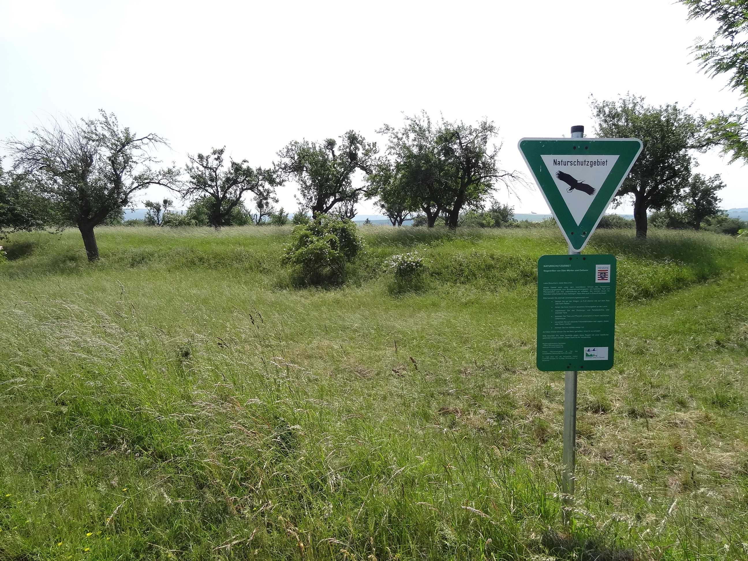
A green nature reserve sign on a metal post standing in a grassy meadow with fruit trees in the background.
Information sign at the Magertriften von Ober-Mörlen und Ostheim nature reserve.

Magertriften von Ober-Mörlen und Ostheim history and protected-area timeline

The site was formally designated as a nature reserve (Naturschutzgebiet) in 1990 under the official identifier 1440023, marking the start of active legal protection for its grassland habitats. The decision to place this relatively small area under protection can be read as part of a broader Hessian effort during the late twentieth century to safeguard remaining fragments of species-rich Magertriften and associated dry grassland communities that traditional land use had once maintained.

Following its designation, the area was recognised within the European Natura 2000 network as the Flora-Fauna-Habitat site 5618-302, embedding it in a continental framework for the conservation of threatened habitats and species. A management plan (Massnahmenplan) was later developed for the FFH area, addressing how the grassland communities should be maintained in the long term through appropriate mowing, grazing, or other habitat-management measures.

Continuous protection since 1990 has allowed the reserve to function as a stable refugium for its characteristic grassland flora and associated fauna, even as surrounding land use has intensified. The site's history therefore reflects a transition from a piece of traditional countryside embedded in everyday agricultural practice to a formally protected conservation area, with management decisions now guiding how the open grassland character is preserved.

Magertriften von Ober-Mörlen und Ostheim landscape and geographic character

The landscape of Magertriften von Ober-Mörlen und Ostheim is shaped by the gentle topography of the southern Wetterau, where low hilltops and shallow valleys transition toward the edge of the Taunus foothills. The Galgenberg, at around 233 metres, is the highest point in the reserve and provides slightly drier, more exposed conditions compared with the lower-lying margins, creating a subtle mosaic of microhabitats across the site.

The Usa river runs along the southern edge of the reserve, while the smaller Fauerbach stream borders parts of the south-western and southern perimeter, carving gentle valleys that interrupt the otherwise open terrain. These watercourses are flanked by narrow riparian zones that introduce more mesic conditions into an otherwise dry-grassland dominated landscape.

Beyond the reserve itself, the surroundings are strongly shaped by infrastructure: the A5 motorway passes to the east, and the B275 federal road runs along the south, together framing the grassland patch within a network of traffic corridors. This contrast between the protected open landscape and the busy transport arteries around it is one of the most visible characteristics of the site's setting in the modern Wetterau.

Magertriften von Ober-Mörlen und Ostheim ecosystems, habitats, and plant life

Ecologically, the reserve is dominated by Magertriften, nutrient-poor dry and semi-dry grasslands typically developed on shallow, base-rich soils. These communities are characterised by a diverse mix of low-growing herbs and grasses, many of which are adapted to low fertility and periodic drought stress, and they tend to support a rich associated fauna of pollinators, grasshoppers, and other invertebrates.

The transition from the higher, drier slopes around the Galgenberg to the lower areas near the Usa and Fauerbach creates a gradient from xeric grassland conditions to more mesic communities, allowing different plant and insect assemblages to coexist within the relatively small area. Scattered shrubs and small woodland elements along the margins add structural diversity and provide habitat edges that benefit both flora and fauna.

Because such Magertriften depend on traditional, low-intensity land use to remain open, the site's ecological value is closely tied to ongoing habitat management. Without regular mowing, grazing, or equivalent interventions, the open grassland would gradually revert to scrub and forest, losing the characteristic species composition that makes the reserve ecologically distinctive.

Magertriften von Ober-Mörlen und Ostheim wildlife and species highlights

The wildlife significance of Magertriften von Ober-Mörlen und Ostheim lies primarily in its invertebrate fauna, which is typical of calcareous and semi-dry grasslands in central Hesse. Dry, herb-rich turf supports a wide range of bees, butterflies, moths, beetles, grasshoppers, and other insects that depend on the particular mix of flowering plants found in Magertriften communities.

These invertebrates in turn provide a food base for a variety of small vertebrates, and the mosaic of open grassland, scattered shrubs, and marginal woodland edges offers nesting, shelter, and foraging opportunities for common bird species of the Wetterau countryside. The reserve's inclusion in the Natura 2000 network reflects the broader importance of such sites for maintaining insect diversity and the ecological linkages that depend on it.

Magertriften von Ober-Mörlen und Ostheim conservation status and protection priorities

Conservation significance at Magertriften von Ober-Mörlen und Ostheim centres on the protection of Magertriften habitat, a category of nutrient-poor grassland that has become rare in Hesse and across much of central Germany due to agricultural intensification, fertilisation, and conversion to cropland. As a designated Naturschutzgebiet since 1990 and an FFH site under the EU Habitats Directive, the reserve forms part of both national and European conservation frameworks.

Management focuses on maintaining the open, species-rich character of the grasslands through measures such as appropriate mowing or grazing regimes, removal of encroaching scrub, and avoidance of nutrient inputs that would favour more competitive, less diverse vegetation. A formal management plan has been developed for the FFH area to guide these activities.

In the broader landscape context, the reserve functions as a refuge and, where conditions allow, a potential source for species associated with dry grassland. Its importance is heightened by the surrounding matrix of roads, including the A5 and the B275, and intensively used farmland, which together limit opportunities for similar habitat elsewhere in the immediate area.

Magertriften von Ober-Mörlen und Ostheim cultural meaning and human context

The reserve lies within a landscape of long-standing agricultural use in the Wetterau, one of the historic breadbaskets of Hesse where small-scale farming, grazing, and hay-making once shaped the rural environment. The very term Magertriften refers to the lean, low-yielding grasslands that were once a typical by-product of this traditional land use, marginal areas that were never ploughed or heavily fertilised.

The hills and ridges within and around the reserve, including the Galgenberg, carry the imprint of older local geographies, where place names such as Galgenberg traditionally referred to historical features of the surrounding countryside. Today, while direct cultural practices are no longer the primary force shaping the land, the reserve preserves a piece of the cultural-natural landscape mosaic that defined the Wetterau for centuries.

Top sights and standout views in Magertriften von Ober-Mörlen und Ostheim

The reserve's key highlights include its strong representation of classic Magertriften dry grassland on base-rich soils, its formal protection as a Naturschutzgebiet since 1990, and its integration into the Natura 2000 network through FFH site 5618-302. The varied topography provided by the Galgenberg and the riparian margins of the Usa and Fauerbach adds ecological depth that exceeds what the modest 77-hectare size might suggest.

A further distinctive feature is its position within a heavily used transport and agricultural landscape, where the contrast between the protected grassland and surrounding motorway, federal road, and farmland highlights the value of securing such habitat fragments in modern central Germany.

Best time to visit Magertriften von Ober-Mörlen und Ostheim

Magertriften von Ober-Mörlen und Ostheim is most rewarding to visit in late spring and early summer, when the dry grassland communities typically reach their peak flowering period and the highest diversity of insects can be observed across the herb-rich turf. Early morning or calm, warm days tend to be best for experiencing butterfly, bee, and grasshopper activity.

In summer, the dry character of the grasslands becomes most visible, with shallow soils and exposed slopes creating the open, herb-rich sward that is characteristic of Magertriften. Autumn visits can still be pleasant for walking and observing the broader landscape, while winter tends to be quiet ecologically, although the open terrain remains accessible for short walks in mild weather.


Monthly climate preview

Annual temperature ranges and precipitation normals from representative point data

Magertriften von Ober-Mörlen und Ostheim Climate Normals and Temperature Patterns

Representative coordinate measurements reveal long-term average monthly temperatures spanning sub-zero winter minimums to warm summer maximums alongside steady precipitation rates. Detailed month-by-month records provide complete climatological normals for tracking annual weather patterns across the protected terrain.
Annual mean9 °C
-1 °C19 °C
Jan-1°
Feb
Mar
Apr
May13°
Jun16°
Jul19°
Aug19°
Sep14°
Oct
Nov
Dec
Warmest month
July

18.8 °C

Coolest month
January

-0.6 °C

Wettest month
July

2.5 mm/day

Driest month
April

1.6 mm/day

Park location guide

Geography guide, regional context, and park location map for Magertriften von Ober-Mörlen und Ostheim

Magertriften von Ober-Mörlen und Ostheim park geography, regions, and map view in Germany

Understand where Magertriften von Ober-Mörlen und Ostheim sits in Germany through a broader geographic reading of the surrounding landscape, nearby location context, and its mapped position within the national park landscape.

How Magertriften von Ober-Mörlen und Ostheim fits into Germany

Germany is a federal republic in Western and Central Europe with a population of over 83 million across sixteen constituent states. It is Europe's largest economy by nominal GDP and a major global exporter and importer. The capital is Berlin, and the country borders Denmark, Poland, Czech Republic, Austria, Switzerland, France, Luxembourg, Belgium, and the Netherlands.

Wider geography shaping Magertriften von Ober-Mörlen und Ostheim in Germany

Germany is located in Western and Central Europe, spanning 357,022 km². It borders Denmark to the north, Poland and the Czech Republic to the east, Austria and Switzerland to the south, and France, Luxembourg, Belgium, and the Netherlands to the west. The country has coastlines on the Baltic Sea and North Sea to the north, with the Alps located in the southern region.

Map view of Magertriften von Ober-Mörlen und Ostheim

Use this park location map to pinpoint Magertriften von Ober-Mörlen und Ostheim in Germany, understand its exact geographic position, and read its mapped placement within the surrounding landscape more clearly.

Pigeon | © OpenStreetMap contributors

Location context for Magertriften von Ober-Mörlen und Ostheim

Hesse
Recorded earthquake history

Review Recorded Seismic Events Near Magertriften von Ober-Mörlen und Ostheim

Access a structured collection of historical earthquake records associated with the area surrounding Magertriften von Ober-Mörlen und Ostheim. MoriAtlas provides this catalogue to support geographic understanding of recorded seismic events through clear, distance-based event mapping.

Magertriften von Ober-Mörlen und Ostheim Earthquake History

Catalogued events

13 events

Strongest magnitude

Magnitude 4.3

Most recent event

Jun 29, 2010

This history includes earthquakes recorded inside the park or within 50 km of its borders

Visual reference collection showcasing dry grassland habitats, rolling terrain, and protected reserve character

Magertriften von Ober-Mörlen und Ostheim Photos, Scenery, and Protected Landscape Views

Examine detailed photographs of Magertriften von Ober-Mörlen und Ostheim to understand its protected dry grassland habitats and gentle valley topography. Visual documentation reveals the distinct ecological character of this central German nature reserve within its surrounding agricultural and transport landscape.

A green nature reserve sign on a metal post standing in a grassy meadow with fruit trees in the background.

Park atlas

Compare nearby nature reserves and protected grassland habitats across the surrounding region

Parks near Magertriften von Ober-Mörlen und Ostheim and Regional Protected Landscapes

Browsing other parks near Magertriften von Ober-Mörlen und Ostheim reveals connected habitat fragments and regional biodiversity refuges across the Wetterau landscape. Comparing these protected areas provides broader geographic context for central German lowland reserves and grassland conservation networks.
A watercolor painting showing a soft, peaceful landscape with green rolling hills, a small body of water in the foreground, and faint, distant mountains under a pale sky.
Nature reserveHesse
About 4.1 km away#1 closest

East

Kiesgrube Laukertsberg bei Nieder-Mörlen Protected Area in Hesse, Germany

A reclaimed post-industrial nature reserve and habitat

Located in the Wetterau district of Hesse, Kiesgrube Laukertsberg bei Nieder-Mörlen represents a significant shift from industrial gravel extraction to protected ecological sanctuary. The terrain features open-ground habitats and seasonal wetlands that support sensitive species, illustrating how landscape management can prioritize biodiversity. Analyze the site boundaries and its role within the broader regional geography of central Germany.

Area
0.157 km²
Established
2019
IUCN
IV
Relief
Lowland
A wide watercolor painting showing a green river valley with marshy foreground, a line of trees, and rolling hills in purple and green in the background.
Nature reserveWetteraukreis
5 km away#2 closest

East

Salzwiesen von Wisselsheim Nature Reserve: Atlas and Regional Geography of Wetteraukreis

Protected inland salt meadows and floodplain geography in Hesse, Germany.

Salzwiesen von Wisselsheim stands as a significant protected area in the Wetteraukreis region, distinguished by rare inland salt meadows fed by natural saline springs. This reserve presents a compelling landscape defined by the River Wetter, offering deep insights into how unique hydrogeology and historical salt production have formed a specialized lowland habitat that is largely absent from other inland regions.

Area
0.23 km²
Established
1982
Relief
Lowland
Climate
Temperate
A wide watercolor illustration showing a purple mountain in the distance, a line of green trees, a body of water, and pinkish plants in the foreground on a white background.
Nature reserveWetteraukreis
About 5.1 km away#3 closest

Northeast

Breitwiese bei Steinfurth und Oppershofen: A Wetteraukreis Nature Reserve Profile

Examining floodplain ecology and protected wetland boundaries

This protected area in the Wetteraukreis highlights the importance of small-scale floodplain management for biodiversity. The site preserves essential wet meadow habitats, riparian edges, and river-adjacent ecosystems that provide sanctuary for specialized amphibian and bird species. It serves as an informative case study for understanding how conservation grazing and corridor protection interact within an intensive agricultural landscape.

Area
0.164 km²
Established
1990
IUCN
IV
Relief
Lowland
A watercolor illustration of a gentle valley landscape with rolling green hills, scattered trees, and a small stream meandering through the center.
Nature reserveHesse
About 9.5 km away#4 closest

Southwest

Röllbachtal bei Usingen: A Protected Stream Valley and Nature Reserve in Hesse

Mapping riparian restoration and low mountain valley habitats

Röllbachtal bei Usingen represents a key protected landscape in the Eastern Hintertaunus of Germany. The nature reserve manages a narrow stream corridor characterized by alder and ash riparian forests, wet meadows, and tall herb floodplain vegetation. This area provides a clear view into the successful restoration of valley habitats and the broader network of protected natural spaces across the Hochtaunuskreis region.

Area
0.739 km²
Established
1999
Relief
Upland
Climate
Temperate
A watercolor painting showing rolling green meadows, trees, and soft distant hills against a white background.
Nature reserveHessen
14 km away#5 closest

South

Kirdorfer Feld bei Bad Homburg: Protected Cultural Landscape and Meadow Reserve Map

Nature reserve and Natura 2000 protected land in Hessen

Kirdorfer Feld bei Bad Homburg serves as a prime example of an intact agricultural cultural landscape, defined by its traditional Streuobstwiesen orchards, damp meadow corridors, and spring-fed wetlands. This site acts as a key ecological anchor within the Taunus foothills, showcasing a unique interplay between managed farmland and protected botanical communities. Learn about the geographic composition of this designated Natura 2000 site.

Area
1.6 km²
Established
1996
Relief
Lowland
Scope
Terrestrial
A horizontal watercolor painting showing a wetland landscape with gentle rolling hills, marshy vegetation, and scattered trees under a light sky.
Nature reserveHesse
About 14 km away#6 closest

East

Bingenheimer Ried Nature Reserve: Mapped Floodplain Geography in Hesse

A critical lowland mire and wetland conservation network

Located in the Horloff valley, Bingenheimer Ried represents an essential protected landscape characterized by seasonal flooding and shallow mire habitats. This nature reserve supports significant bird populations and diverse aquatic life, functioning as a primary reference point for floodplain management and conservation geography within the state of Hesse.

Area
0.85 km²
Established
1985
A watercolor painting showing a soft, pastoral landscape with green trees, rolling hills, and purple-toned wetland areas against a white background.
Nature reserveHessen
About 15 km away#7 closest

Northwest

Egelpfuhl bei Oberwetz Nature Reserve: A Protected Wetland Sanctuary in Hessen, Germany

Geographic overview of a protected wet meadow valley in the Lahn-Dill district.

Egelpfuhl bei Oberwetz occupies a 10.75-hectare valley hollow defined by its moist soils and near-natural brook course. This nature reserve supports a structured habitat for endangered meadow butterflies and birds, acting as an essential ecological bridge within the intensively farmed landscape of central Germany.

Area
0.108 km²
Established
1990
IUCN
IV
Watercolor painting of a green landscape with rolling hills, small clusters of trees, and soft pinkish tones in the background.
Nature reserveHesse
About 19 km away#8 closest

Southeast

Krebsbachtal bei Kaichen: Protected Stream Valley Geography and Landscape Map in Hesse

Nature reserve featuring diverse meadow and forest habitat mosaics

Spanning 34 hectares in the Main-Kinzig-Kreis, the Krebsbachtal bei Kaichen reserve protects a unique concentration of riparian stream life, dry grasslands, and traditional orchard meadows. This valley landscape, framed by the Hainwald forest, provides a protected corridor that remains a significant representative of the historic natural terrain found in central Hesse.

Area
0.34 km²
Established
1988
Relief
Lowland
Climate
Temperate

Common questions about visiting, size, designation, and location context for Magertriften von Ober-Mörlen und Ostheim

Magertriften von Ober-Mörlen und Ostheim FAQs for park facts, access, geography, and protected area context

Find quick answers about Magertriften von Ober-Mörlen und Ostheim, including protected-area facts, park geography, trail and visitor context, and how the park fits into its surrounding country and regional landscape.
MoriAtlas Explorer

Continue Your Protected Areas Search Across the Global Atlas

Deepen your exploration by continuing the structured search for national parks and protected areas worldwide. Utilize the comprehensive filtering capabilities to compare different conservation landscapes and refine your understanding of global park geography. Discover more about the distribution and characteristics of protected natural areas.

Global natural geography