
Mori Atlas logo
Nature reserveSalzwiesen von Wisselsheim

Understanding the geography of inland salt meadows, saline springs, and riverine habitats along the River Wetter.

Salzwiesen von Wisselsheim Nature Reserve and the Wetteraukreis Protected Floodplain Landscape

Salzwiesen von Wisselsheim encompasses a rare inland salt meadow ecosystem sustained by natural saline springs in the Wetterau lowlands of Germany. This nature reserve provides a critical study of floodplain geography, where saline groundwater and the River Wetter shape a distinct terrain characterized by salt-tolerant plant communities and remnant historical salt production infrastructure. Situated within the Auenverbund Wetterau, the site serves as a vital component of local conservation efforts for protected wetlands and alluvial forests.

inland salt meadowssalt springsfloodplainriver habitatalluvial forestnature reserve
A stylized vector illustration showing a winding river flowing through a green valley with patchwork fields, trees in the foreground, and distant hills under a bright sun.

Salzwiesen von Wisselsheim

Nature reserve

Park overview

Structured park overview, official facts, and landscape profile for Salzwiesen von Wisselsheim

Salzwiesen von Wisselsheim park facts, protected area profile, and essential visitor context

Review the core facts for Salzwiesen von Wisselsheim, including designation, size, terrain, visitor scale, habitats, and operating context in one park-focused overview.

About Salzwiesen von Wisselsheim

Salzwiesen von Wisselsheim is a compact but ecologically distinctive nature reserve in the Wetteraukreis district of Hesse, Germany. It lies between the Bad Nauheim districts of Wisselsheim and Steinfurth, extending roughly 1,300 meters along the River Wetter, which forms much of the western boundary of the protected area. At the Eichberg, the river crosses through the reserve, after which the Selzerbrunnen salt spring forms part of the eastern edge.

The reserve's identity is rooted in a rare geological and hydrological anomaly: the presence of naturally saline groundwater. Salt has been documented at the site since 1266, when the Wisselsheimer Salzsode, or Wisselsheim salt well, was recorded in historical documents. From the sixteenth century onward, large graduation towers (Gradierbauten) totaling about 500 meters in length were used to concentrate the brine, though these structures were abandoned around 1830 and the salt operations were eventually sold to the town of Bad Salzhausen.

The historical administrative building of the salt works was relocated to Steinfurth, where it now houses the Rosenmuseum. The remaining parts of the former complex include the Hofgut Löwenthal, which occupies the old administrative site. Geographically, although the reserve carries Wisselsheim's name, most of its area lies within Steinfurth's municipal territory, while the Selzerbrunnen and the lands of the former saline works belong to Nieder-Mörlen.

Ecologically, the site is significant for protecting inland salt meadows, a habitat type that has almost disappeared from central European landscapes following centuries of agricultural drainage. The combination of saline soils and floodplain conditions produces a specialized meadow community that supports halophytic plant species. The reserve has been formally protected as a Naturschutzgebiet since 1982 and is also designated as an FFH area, confirming its importance under European Union habitat conservation frameworks. The three FFH habitat types recognized within its boundaries include inland salt meadows, lowland river vegetation, and alluvial forests dominated by alder and ash.

Quick facts and research context for Salzwiesen von Wisselsheim

Salzwiesen von Wisselsheim is a nature reserve of approximately 23 hectares situated along about 1,300 meters of the River Wetter in Hesse. It was designated as a protected area on 1 February 1982 and is additionally classified as an FFH area (site number 5618-301). The reserve falls within the Wetterau bird protection area and the Auenverbund Wetterau landscape protection area. Salt springs, including the Selzerbrunnen, are a defining hydrological feature of the site and have historically supported salt production dating back to at least 1266.

Protection and recognition

Examine documented terrestrial conservation frameworks and Natura 2000 records.

Salzwiesen von Wisselsheim Protection Status and International Recognition Data

Salzwiesen von Wisselsheim holds documented terrestrial protection status alongside verified Natura 2000 recognition sources in the global database. Conservation analysts review these official records to understand the protected area designation and management scope without relying on external assumptions.

International recognition

Protection details

Protection scope
Terrestrial
Transboundary protection
No
WDPA ID
82481
Park context

Deeper park guide and search-rich context for Salzwiesen von Wisselsheim

Salzwiesen von Wisselsheim history, landscape, wildlife, and travel context

Explore Salzwiesen von Wisselsheim through its history, landscape character, ecosystems, wildlife, conservation priorities, cultural context, and seasonal travel timing in a structured park guide built for atlas discovery and search intent.

Why Salzwiesen von Wisselsheim stands out

The reserve is best known for its inland salt meadows, one of the rarest habitat types in central Europe, sustained by natural saline springs in the Wetterau. These conditions have produced a unique plant community adapted to salty soils that is almost nonexistent elsewhere in inland Germany. The site also preserves fragments of the historic Wisselsheim salt works, including references to Gradierwerke, or graduation towers, that were used for centuries to evaporate brine.
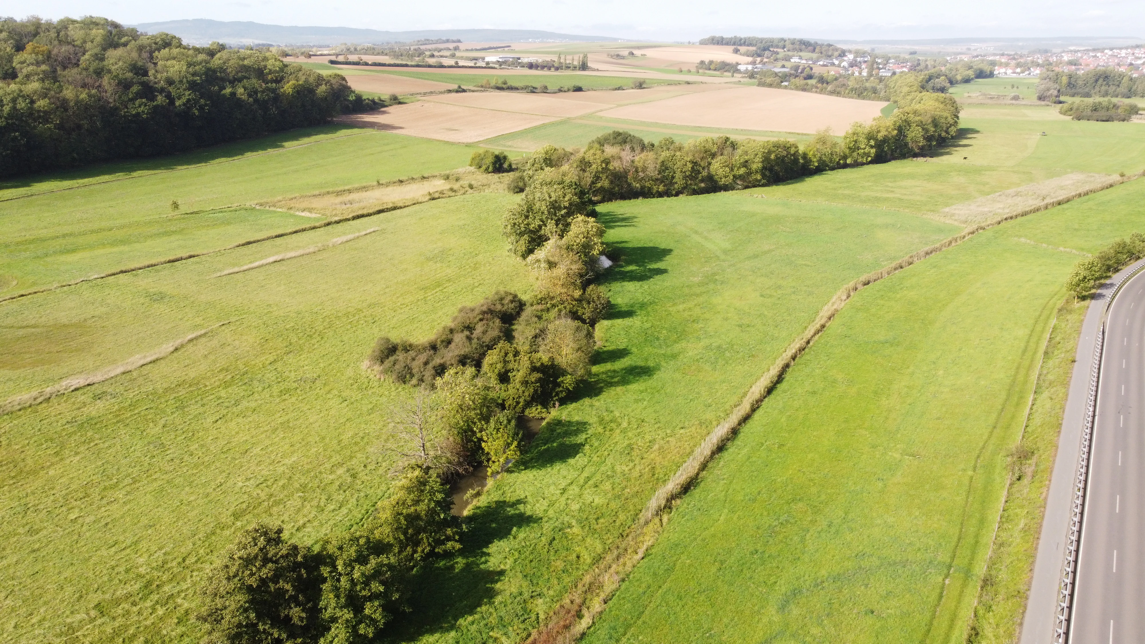
An aerial photograph showing a wide expanse of green meadows and fields, with a line of trees running through the center and a highway visible on the right edge.
Aerial view of the Salzwiesen von Wisselsheim nature reserve showing green meadows and the tree-lined course of the Wetter river.

Salzwiesen von Wisselsheim history and protected-area timeline

The history of Wisselsheim's salt meadows extends back more than seven centuries. The first documented reference to salt production at the site appears in 1266, when the Wisselsheimer Salzsode is mentioned in historical records. For several hundred years afterward, the natural saline springs supported an active salt extraction industry.

From the sixteenth century, large graduation towers with a combined length of around 500 meters were used to accelerate the evaporation of brine and concentrate the salt. These structures formed an important local industry until approximately 1830, when the salt works were abandoned and the entire operation was sold to the town of Bad Salzhausen.

The administrative building of the former complex was rebuilt in Steinfurth, where it now serves as the Rosenmuseum, or Rose Museum. The remaining structures on the original site now house the Hofgut Löwenthal. Although Wisselsheim lends its name to the reserve, the majority of the protected area lies administratively within Steinfurth, and the Selzerbrunnen and former saline lands remain part of Nieder-Mörlen.

Modern conservation history began with the formal designation of the area as a Naturschutzgebiet, or nature reserve, on 1 February 1982. It was later incorporated into the European Union's FFH network of protected habitat sites under site number 5618-301.

Salzwiesen von Wisselsheim landscape and geographic character

The landscape of Salzwiesen von Wisselsheim is defined by the floodplain of the River Wetter and the influence of saline groundwater that emerges in springs such as the Selzerbrunnen. The terrain is flat and low-lying, characteristic of the Wetterau lowlands, and the protected area extends about 1,300 meters in a generally linear pattern along the river.

The River Wetter plays a central role in shaping the scenery. It runs primarily along the western edge of the reserve but crosses through the area at the Eichberg, after which it forms the eastern boundary together with the Selzerbrunnen spring. The Riedgraben stream joins the Wetter at the northern border, adding to the mosaic of small watercourses that define the floodplain environment.

The most visually distinctive aspect of the landscape is its unusual salinity, a reminder of the area's long association with salt production. Although the nineteenth-century graduation towers no longer dominate the scene, the saline soils and historic infrastructure remnants remain visible traces of this heritage. The combination of wet meadows, alluvial forests, riverine vegetation, and salt-influenced ground gives the area a layered character that contrasts sharply with surrounding agricultural land.

Salzwiesen von Wisselsheim ecosystems, habitats, and plant life

Salzwiesen von Wisselsheim protects an unusually diverse set of habitats for such a small site, anchored by the rare presence of inland salt meadows. Saline seeps and springs, including the Selzerbrunnen, create chemically unusual soil conditions that support plant species adapted to high salt concentrations. These inland salt meadows are considered one of the rarest habitat types in central Europe, having been lost from most other parts of the region through drainage and conversion to farmland.

The reserve also includes stretches of the River Wetter classified as a lowland to montane river with floating vegetation of the Ranunculion fluitantis and Callitricho-Batrachion types. This habitat supports submerged and floating aquatic plants that thrive in the relatively clean, slow-moving stretches of the river within the reserve's boundaries.

Along the floodplain, the third major habitat type is alluvial forest dominated by black alder (Alnus glutinosa) and ash (Fraxinus excelsior), representing the Alno-Padion, Alnion incanae, and Salicion albae communities. These moist, periodically flooded woodlands form a transitional edge between the open meadows and the river channel, contributing to a habitat mosaic that has been prioritized for protection under the European Union's Habitats Directive.

Salzwiesen von Wisselsheim wildlife and species highlights

The reserve's position within the Wetterau bird protection area supports its importance for birdlife, especially species associated with meadow, wetland, and floodplain environments. The mosaic of saline meadows, river vegetation, and alluvial forest provides nesting and feeding habitat for a range of Wetterau lowland bird communities.

The presence of slow-moving stretches of the River Wetter with characteristic aquatic vegetation also creates habitat for aquatic invertebrates, fish, and amphibians adapted to lowland river conditions. The wet meadows and saline soils support specialized insect communities tied to halophytic plants.

While the source material does not enumerate specific species, the combination of protected habitat types, the FFH designation, and inclusion in the broader Wetterau bird protection network indicates that the site serves as a refuge for wetland and grassland fauna typical of the Wetterau region's surviving floodplain ecosystems.

Salzwiesen von Wisselsheim conservation status and protection priorities

Salzwiesen von Wisselsheim holds conservation significance at multiple scales, from local nature protection to European habitat networks. Its formal designation as a Naturschutzgebiet in 1982 marked the beginning of legal protection for one of the few remaining inland salt meadows in Germany, a habitat type that has suffered severe losses across central Europe.

The site's inclusion in the European Union's FFH network under site number 5618-301 reflects its importance for protecting habitat types listed under the EU Habitats Directive. Three formally recognized FFH habitat types occur within the reserve: inland salt meadows, lowland river communities, and alluvial alder-ash forests. Each of these habitat types is considered of conservation concern across Europe.

The reserve is also embedded in two overlapping landscape-scale designations: the Wetterau bird protection area (Vogelschutzgebiet) and the Auenverbund Wetterau landscape protection area (Landschaftsschutzgebiet). This stacking of protections emphasizes the role of the Wisselsheim meadows within a broader floodplain conservation network in the Wetterau, linking local saline meadow protection to regional wetland and bird conservation strategies.

Salzwiesen von Wisselsheim cultural meaning and human context

The cultural identity of the Wisselsheim area is deeply tied to its long history of salt production. Salt-making is documented here from 1266 onward, and the site was an important regional source of brine for centuries, with large graduation towers operating from the sixteenth century until about 1830.

Although the salt industry itself ended in the nineteenth century, its physical and institutional legacy survives. The administrative building of the former salt works, the Rentamt, was relocated to Steinfurth and now houses the Rosenmuseum, a museum dedicated to roses that ties the area's heritage to broader regional identity.

The remaining parts of the former complex include the Hofgut Löwentral, located in the old administrative structure. Together with the Selzerbrunnen and the surviving meadows, these cultural elements connect the protected landscape to centuries of human interaction with a rare and economically valuable natural resource.

Top sights and standout views in Salzwiesen von Wisselsheim

Among the most distinctive features of Salzwiesen von Wisselsheim are its inland salt meadows, sustained by natural saline springs in an otherwise non-saline region of Hesse; its integration into a layered system of nature, FFH, bird protection, and landscape protection designations; and its historical association with centuries of documented salt production, including sixteenth-century graduation towers.

The reserve's position along the River Wetter adds a complementary freshwater habitat dimension, supporting lowland river and alluvial forest communities alongside the saline meadows. The combination of historical depth, ecological rarity, and multi-level legal protection makes the site a compact but unusually rich example of Wetterau floodplain conservation.

Best time to visit Salzwiesen von Wisselsheim

The meadows and floodplain landscapes of the Wetterau are most visually expressive in late spring and summer, when grassland vegetation reaches its full growth and the riverine habitats are most active. Spring and early summer tend to highlight wildflower displays in meadow habitats, while summer offers the most diverse insect and bird activity. Autumn can bring quieter atmospheric conditions and clearer views of the floodplain structure, though the saline meadow character remains evident across seasons. Visitors interested in birdlife may find late spring and early summer particularly rewarding for observing meadow and wetland species within the broader Wetterau bird protection area.

Monthly climate preview

Long term monthly temperature averages and precipitation patterns measured at representative coordinates

Salzwiesen von Wisselsheim Annual Climate Normals and Temperature Rhythms

Salzwiesen von Wisselsheim records long term monthly temperature ranges and steady daily precipitation rates across a representative elevation of 299 meters. Examining the complete twelve month climate profile reveals detailed shifts in average minimum and maximum temperatures throughout the year.
Annual mean9 °C
-1 °C19 °C
Jan-1°
Feb
Mar
Apr
May13°
Jun16°
Jul19°
Aug19°
Sep14°
Oct
Nov
Dec
Warmest month
July

18.8 °C

Coolest month
January

-0.6 °C

Wettest month
July

2.5 mm/day

Driest month
April

1.6 mm/day

Park location guide

Geography guide, regional context, and park location map for Salzwiesen von Wisselsheim

Salzwiesen von Wisselsheim park geography, regions, and map view in Germany

Understand where Salzwiesen von Wisselsheim sits in Germany through a broader geographic reading of the surrounding landscape, nearby location context, and its mapped position within the national park landscape.

How Salzwiesen von Wisselsheim fits into Germany

Germany is a federal republic in Western and Central Europe with a population of over 83 million across sixteen constituent states. It is Europe's largest economy by nominal GDP and a major global exporter and importer. The capital is Berlin, and the country borders Denmark, Poland, Czech Republic, Austria, Switzerland, France, Luxembourg, Belgium, and the Netherlands.

Wider geography shaping Salzwiesen von Wisselsheim in Germany

Germany is located in Western and Central Europe, spanning 357,022 km². It borders Denmark to the north, Poland and the Czech Republic to the east, Austria and Switzerland to the south, and France, Luxembourg, Belgium, and the Netherlands to the west. The country has coastlines on the Baltic Sea and North Sea to the north, with the Alps located in the southern region.

Map view of Salzwiesen von Wisselsheim

Use this park location map to pinpoint Salzwiesen von Wisselsheim in Germany, understand its exact geographic position, and read its mapped placement within the surrounding landscape more clearly.

Pigeon | © OpenStreetMap contributors

Location context for Salzwiesen von Wisselsheim

Wetteraukreis
Recorded earthquake history

Explore the Historical Earthquake Catalogue for Salzwiesen von Wisselsheim

Review the recorded seismic history associated with this nature reserve through a detailed, location-based database. MoriAtlas provides a clear archive of events to help you trace documented earthquake activity in the surrounding Wetteraukreis landscape.

Salzwiesen von Wisselsheim Earthquake Records

Catalogued events

13 events

Strongest magnitude

Magnitude 4.3

Most recent event

Jun 29, 2010

This history includes earthquakes recorded inside the park or within 50 km of its borders

Visual reference collection highlighting inland salt meadows and floodplain terrain

Salzwiesen von Wisselsheim Landscape Photos and Protected Area Scenery

Photographic records reveal the distinct salt meadows, riverine floodplains, and saline spring environments that define Salzwiesen von Wisselsheim. Visual documentation provides deep insight into rare central European wetland habitats and protected terrain.

An aerial photograph showing a wide expanse of green meadows and fields, with a line of trees running through the center and a highway visible on the right edge.

Park atlas

Compare regional river floodplains, salt meadows, and protected habitats across Hesse.

Other Parks Near Salzwiesen von Wisselsheim and Surrounding Protected Landscapes

Browse nearby protected areas and connected floodplain habitats located around Salzwiesen von Wisselsheim to compare regional ecological zones. Discovering adjacent nature reserves provides broader geographic context for rare inland saline ecosystems.
A watercolor painting showing a soft, peaceful landscape with green rolling hills, a small body of water in the foreground, and faint, distant mountains under a pale sky.
Nature reserveHesse
About 0.9 km away#1 closest

West

Kiesgrube Laukertsberg bei Nieder-Mörlen Protected Area in Hesse, Germany

A reclaimed post-industrial nature reserve and habitat

Located in the Wetterau district of Hesse, Kiesgrube Laukertsberg bei Nieder-Mörlen represents a significant shift from industrial gravel extraction to protected ecological sanctuary. The terrain features open-ground habitats and seasonal wetlands that support sensitive species, illustrating how landscape management can prioritize biodiversity. Analyze the site boundaries and its role within the broader regional geography of central Germany.

Area
0.157 km²
Established
2019
IUCN
IV
Relief
Lowland
A wide watercolor illustration showing a purple mountain in the distance, a line of green trees, a body of water, and pinkish plants in the foreground on a white background.
Nature reserveWetteraukreis
About 2.2 km away#2 closest

North

Breitwiese bei Steinfurth und Oppershofen: A Wetteraukreis Nature Reserve Profile

Examining floodplain ecology and protected wetland boundaries

This protected area in the Wetteraukreis highlights the importance of small-scale floodplain management for biodiversity. The site preserves essential wet meadow habitats, riparian edges, and river-adjacent ecosystems that provide sanctuary for specialized amphibian and bird species. It serves as an informative case study for understanding how conservation grazing and corridor protection interact within an intensive agricultural landscape.

Area
0.164 km²
Established
1990
IUCN
IV
Relief
Lowland
Protected areaGermany
5 km away#3 closest

West

Magertriften von Ober-Mörlen und Ostheim Protected Area Geography and Map

A vital nutrient-poor grassland refuge in Hesse, Germany

Located in the Wetteraukreis district, the Magertriften von Ober-Mörlen und Ostheim protected area preserves a rare, species-rich grassland habitat on base-rich soils. This 77-hectare reserve, integrated into the Natura 2000 network, offers a stark contrast between its preserved dry-grassland ecosystems and the surrounding agricultural and industrial transport landscape of central Germany.

Area
0.775 km²
Established
1990
Relief
Lowland
Scope
Terrestrial
A horizontal watercolor painting showing a wetland landscape with gentle rolling hills, marshy vegetation, and scattered trees under a light sky.
Nature reserveHesse
About 8.8 km away#4 closest

East

Bingenheimer Ried Nature Reserve: Mapped Floodplain Geography in Hesse

A critical lowland mire and wetland conservation network

Located in the Horloff valley, Bingenheimer Ried represents an essential protected landscape characterized by seasonal flooding and shallow mire habitats. This nature reserve supports significant bird populations and diverse aquatic life, functioning as a primary reference point for floodplain management and conservation geography within the state of Hesse.

Area
0.85 km²
Established
1985
A horizontal watercolor illustration showing a meandering stream flowing through open green grasslands with scattered trees and low hills in the background.
Nature reserveHessen
About 13 km away#5 closest

East

Nachtweid von Dauernheim Nature Reserve: Geographic Overview and Wetland Conservation

Saline meadows and floodplain habitats in Hessen

Nachtweid von Dauernheim is a specialized nature reserve in the Wetterau district, defined by its rare saline-influenced grassland flora and extensive sedge marshes. As a core rail bird biotope, the site anchors a wider wetland network alongside the Nidda river floodplain. This protected area offers a deep look into central Germany's unique hydrologic conditions and sensitive open-terrain conservation.

Area
0.789 km²
Established
1978
A watercolor illustration of a gentle valley landscape with rolling green hills, scattered trees, and a small stream meandering through the center.
Nature reserveHesse
About 15 km away#6 closest

West

Röllbachtal bei Usingen: A Protected Stream Valley and Nature Reserve in Hesse

Mapping riparian restoration and low mountain valley habitats

Röllbachtal bei Usingen represents a key protected landscape in the Eastern Hintertaunus of Germany. The nature reserve manages a narrow stream corridor characterized by alder and ash riparian forests, wet meadows, and tall herb floodplain vegetation. This area provides a clear view into the successful restoration of valley habitats and the broader network of protected natural spaces across the Hochtaunuskreis region.

Area
0.739 km²
Established
1999
Relief
Upland
Climate
Temperate
Watercolor painting of a green landscape with rolling hills, small clusters of trees, and soft pinkish tones in the background.
Nature reserveHesse
About 16 km away#7 closest

Southeast

Krebsbachtal bei Kaichen: Protected Stream Valley Geography and Landscape Map in Hesse

Nature reserve featuring diverse meadow and forest habitat mosaics

Spanning 34 hectares in the Main-Kinzig-Kreis, the Krebsbachtal bei Kaichen reserve protects a unique concentration of riparian stream life, dry grasslands, and traditional orchard meadows. This valley landscape, framed by the Hainwald forest, provides a protected corridor that remains a significant representative of the historic natural terrain found in central Hesse.

Area
0.34 km²
Established
1988
Relief
Lowland
Climate
Temperate
A watercolor painting showing rolling green meadows, trees, and soft distant hills against a white background.
Nature reserveHessen
17 km away#8 closest

Southwest

Kirdorfer Feld bei Bad Homburg: Protected Cultural Landscape and Meadow Reserve Map

Nature reserve and Natura 2000 protected land in Hessen

Kirdorfer Feld bei Bad Homburg serves as a prime example of an intact agricultural cultural landscape, defined by its traditional Streuobstwiesen orchards, damp meadow corridors, and spring-fed wetlands. This site acts as a key ecological anchor within the Taunus foothills, showcasing a unique interplay between managed farmland and protected botanical communities. Learn about the geographic composition of this designated Natura 2000 site.

Area
1.6 km²
Established
1996
Relief
Lowland
Scope
Terrestrial

Common questions about visiting, size, designation, and location context for Salzwiesen von Wisselsheim

Salzwiesen von Wisselsheim FAQs for park facts, access, geography, and protected area context

Find quick answers about Salzwiesen von Wisselsheim, including protected-area facts, park geography, trail and visitor context, and how the park fits into its surrounding country and regional landscape.
MoriAtlas Explorer

Continue Your Protected Areas Search Across the Global Atlas

Deepen your exploration by continuing the structured search for national parks and protected areas worldwide. Utilize the comprehensive filtering capabilities to compare different conservation landscapes and refine your understanding of global park geography. Discover more about the distribution and characteristics of protected natural areas.

Global natural geography