Mori Atlas logo
Nature reserveOxford Island

Understanding the geography of this lowland lakeshore habitat in Northern Ireland

Oxford Island Nature Reserve: A Mapped Exploration of Lough Neagh Freshwater Wetland Landscapes

(Oxford Island National Nature Reserve)

Oxford Island represents a key protected landscape along the southern shores of Lough Neagh. The reserve preserves a distinct mosaic of mixed woodland, species rich wildflower meadows, and reed beds that define the local freshwater wetland terrain. This area offers a unique view into lowland lakeshore ecology and provides essential shelter for significant winter wildfowl populations within the broader geography of Northern Ireland.

national nature reservewetlandlough shoremixed woodlandwildflower meadowreed beds

Oxford Island

Nature reserve

Park overview

Structured park overview, official facts, and landscape profile for Oxford Island

Oxford Island park facts, protected area profile, and essential visitor context

Review the core facts for Oxford Island, including designation, size, terrain, visitor scale, habitats, and operating context in one park-focused overview.

About Oxford Island

Oxford Island occupies a distinctive position where the cultural landscape of Northern Ireland meets one of the most ecologically significant freshwater systems in Europe. The reserve lies on the southeastern edge of Lough Neagh, Britain's largest inland lake by area, and combines woodland, grassland, wetland, and shoreline into a compact and varied protected site.

Although commonly called an island, the area has not been truly insular since 1846, when the water level of Lough Neagh was artificially lowered for the first time, turning it into a peninsula connected to the surrounding shore. The site's later identity as a nature reserve dates to the late 1960s, when it was acquired under the Craigavon New City Plans as a place for public recreation. At that stage, most of the land had been cultivated or grazed, and natural vegetation cover had largely disappeared. Decades of mixed woodland planting, natural shoreline regeneration, and the recovery of species-rich grassland have since reshaped the reserve into a functioning biodiversity refuge.

The site is owned and managed by Armagh City, Banbridge and Craigavon Borough Council, and the dual objectives of biodiversity maintenance and public enjoyment are central to its identity. Mixed woodland paths, open meadows, lakeshore reed beds, and viewing points along the lough coexist with active visitor infrastructure including the Lough Neagh Discovery Centre, walking trails spanning several miles, and an artist's studio. The result is a reserve that pairs genuine ecological recovery with a welcoming public experience.

Ecologically, Oxford Island sits within a much larger wetland context. Lough Neagh as a whole has been designated a Special Protection Area under European Union legislation because of the sheer volume of wintering wildfowl it attracts, and Oxford Island functions as an integral part of that network. Its own biodiversity includes rare and common wildflowers, more than a dozen butterfly species, dozens of moth species, a wide range of freshwater fish, and seasonally changing bird populations that connect the site to migratory flyways stretching across the North Atlantic.

Quick facts and research context for Oxford Island

Oxford Island sits on the southern shore of Lough Neagh, the largest freshwater lake in the British Isles, close to the town of Lurgan in County Armagh, Northern Ireland. The site covers 282 acres and operates as both a National Nature Reserve and a public recreation area, owned and managed by Armagh City, Banbridge and Craigavon Borough Council.

The reserve embraces mixed woodland, meadows, reed beds, and shoreline, supporting a wide range of plants, butterflies, freshwater fish, and birds. Its status as part of the Lough Neagh Special Protection Area links it to one of the most important wetland systems in the United Kingdom.

Protection and recognition

Examine the official protection framework and terrestrial designation data.

Oxford Island Protection Status and Documented Conservation Scope

Oxford Island maintains a documented terrestrial protection scope within the regional conservation inventory. Structured records compile the known designation history and management parameters for geographic analysis.

Protection details

Protection scope
Terrestrial
Transboundary protection
No
Park context

Deeper park guide and search-rich context for Oxford Island

Oxford Island history, landscape, wildlife, and travel context

Explore Oxford Island through its history, landscape character, ecosystems, wildlife, conservation priorities, cultural context, and seasonal travel timing in a structured park guide built for atlas discovery and search intent.

Why Oxford Island stands out

Oxford Island is best known for its combination of reclaimed lakeshore habitat and accessible wildlife on the edge of Lough Neagh. The reserve showcases how former agricultural land along a major freshwater lake can be restored into a mosaic of woodland, wildflower meadows, and reed beds that shelter an unusually varied range of species. Particular recognition comes from the site's contribution to Lough Neagh's status as a Special Protection Area, especially for wintering wildfowl that travel from Iceland, Scandinavia, and Siberia. The reserve is also notable as a public-facing nature reserve, hosting the Lough Neagh Discovery Centre alongside walking trails, a marina, and educational facilities that bring wetland ecology to a broad audience.

Oxford Island history and protected-area timeline

Oxford Island's modern history begins in the mid-nineteenth century. In 1846, the water level of Lough Neagh was artificially lowered for the first time, a change that turned the former island into a peninsula and fundamentally altered its relationship with the surrounding land. For more than a century afterward, much of the area continued in agricultural use, and natural vegetation cover across the site was largely eradicated by cultivation and grazing.

A significant shift came with the Craigavon New City Plans, under which Oxford Island was identified as a site for public recreation and acquired by what was then Craigavon Borough Council in the late 1960s. The site's transition from working farmland to a managed green space marks the beginning of its modern nature reserve identity. Thousands of mixed woodland trees were planted over subsequent decades, the lough shoreline was allowed to develop naturally, and former meadows gradually reverted to species-rich grassland rather than being maintained as improved pasture.

In 1993, the Lough Neagh Discovery Centre was built on the site, anchoring Oxford Island's role as both a conservation area and a public education hub. Conservation management has continued to evolve, including hay cutting in selected grassland areas, conservation grazing with rare breeds such as Irish Moiled and Dexter cattle, and ongoing efforts to control invasive species such as Himalayan Balsam while protecting sensitive reed bed habitat along the shoreline.

Oxford Island landscape and geographic character

The landscape of Oxford Island is defined by its position on the shoreline of Lough Neagh, the largest freshwater lake in the British Isles. Rather than a dramatic upland or mountainous terrain, the reserve exemplifies a lowland lakeshore environment where water, woodland, and grassland meet in close succession. The muted, flat-to-gently-undulating character of the surrounding drumlin-influenced countryside is part of the area's subtle appeal.

Inside the reserve, woodland forms a major structural element. Mixed woodland plantations, established during and after the council's acquisition of the site, give the landscape a layered feel, with paths winding between native and introduced tree species. These wooded areas transition into open meadows that have reverted to species-rich grassland, providing seasonal colour and contrasting open spaces against the dense canopy.

Along the lough edge, the shoreline is one of the most important landscape features of the reserve. Reed beds have been actively encouraged by removing encroaching scrub, creating a buffer zone between open water and terrestrial habitats. Views across the broad surface of Lough Neagh from the Discovery Centre, trails, and marina are a defining scenic element, and the gentle, expansive waterscape gives the reserve its quiet, contemplative atmosphere.

Oxford Island ecosystems, habitats, and plant life

Oxford Island showcases a compact but ecologically rich mosaic of habitats. Mixed woodland, species-rich wildflower meadows, freshwater reed beds, and open shoreline of Lough Neagh all coexist within a relatively small footprint, illustrating how diverse wetland-edge systems can be supported when agricultural pressure is relaxed and habitats are actively managed.

The reserve's woodland absorbs and softens the surrounding agricultural landscape, while the meadows echo the kind of unimproved grassland that has become increasingly rare in lowland Northern Ireland. Reed beds along the lough shore host distinctive wetland flora and provide crucial cover and feeding grounds for birds and insects. The shoreline habitat is managed to reduce scrub encroachment, allowing reeds to expand and helping sustain the structural diversity that wetland wildlife depends on.

Vegetation within the reserve is characterised by both rare and common wild plants, including common bluebell, red campion, several orchid species, yellow rattle, ragged robin, and flowering rush. The presence of native bluebell-rich woodland alongside traditional meadow wildflowers gives the site a strong seasonal rhythm, with spring woodland flowers followed by summer meadow blooms and autumn seed heads that feed overwintering birds.

Oxford Island wildlife and species highlights

Wildlife is at the heart of Oxford Island's identity, with the reserve's fauna reflecting both its habitat diversity and its location beside one of Europe's most important freshwater wetlands.

The site supports a rich butterfly community, with species such as large white, small white, green-veined white, wood white, orange tip, small tortoiseshell, meadow brown, ringlet, speckled wood, common blue, small heath, small copper, red admiral, and European peacock all recorded. Around sixty species of moth have also been documented, reinforcing the reserve's value for invertebrate conservation alongside its better-known birdlife.

Freshwater fish associated with the wider Lough Neagh system are part of the reserve's ecological story. Northern pike, perch, roach, common bream, brown trout, eel, gudgeon, lamprey, pollan, rainbow trout, dollaghan, and migratory salmon all inhabit the surrounding waters, with the Lough's traditional reputation for eels and pollan lending cultural as well as ecological significance.

Birdlife is particularly striking. In winter, the lough shore and surrounding fields attract large flocks of goldeneye, common pochard, tufted duck, greater scaup, Eurasian teal, wigeon, whooper swan, Bewick's swan, lapwing, and curlew, many arriving from Iceland, Scandinavia, and Siberia. In summer, species such as common tern, sedge warbler, willow warbler, common house martin, and swallow bring a different seasonal character. The reserve also hosts the famous Lough Neagh Chironomid midge fly, whose enormous swarms form a vital food source linking the lake's ecology to its fish and bird populations.

Oxford Island conservation status and protection priorities

Conservation is the guiding principle of Oxford Island, with all site management oriented around maintaining and enhancing biodiversity alongside providing public access. The reserve's protected status at multiple levels, including its own National Nature Reserve designation and its role within the Lough Neagh Special Protection Area, places it within both national and European conservation frameworks.

Active management is central to how the reserve functions ecologically. Grassland areas are managed through a combination of traditional hay cutting and conservation grazing by rare breeds such as Irish Moiled and Dexter cattle, which help maintain the open structure of meadow habitats. The lough shoreline is managed to allow reed beds to flourish, including targeted scrub removal to prevent woody species from crowding out wetland vegetation.

The reserve also plays an ongoing role in invasive species control, with efforts to manage plants such as Himalayan Balsam that can otherwise suppress native flora. Together, these interventions reflect a conservation approach that combines habitat restoration, low-intensity traditional land management, and modern ecological monitoring, all within an area that remains open and welcoming to visitors.

Oxford Island cultural meaning and human context

Oxford Island's cultural context is intimately tied to Lough Neagh, a lake long embedded in the folklore, fishing traditions, and identity of Northern Ireland. The reserve sits within a landscape that has shaped local livelihoods for centuries, particularly through fishing for species such as eel and pollan, which remain distinctive cultural and ecological markers for the region.

The site's acquisition and transformation under the Craigavon New City Plans reflects a deliberate post-war planning choice to integrate green space and public recreation into the design of a new city. That heritage, combined with ongoing partnerships such as the Lagan Canal Trust's presence at the Discovery Centre and the restored Enterprize Barge, an inland waterways lighter, connects Oxford Island to broader narratives of industrial heritage, waterway restoration, and community-led conservation in Northern Ireland.

Top sights and standout views in Oxford Island

Oxford Island's most distinctive qualities lie at the intersection of accessible recreation and meaningful wetland conservation. The reserve offers a rare opportunity to experience mixed woodland, wildflower meadows, reed beds, and open lough shore all within a short walk of one another.

Its contribution to the internationally recognised winter wildfowl populations of Lough Neagh, combined with a strong butterfly and moth community, ranges of freshwater fish, and seasonal breeding birds, makes the reserve ecologically far richer than its compact size might suggest. The presence of the Lough Neagh Discovery Centre, an artist's studio, marina, and restored inland waterways barge reinforces the site's identity as a place where nature, culture, and public enjoyment intersect.

Best time to visit Oxford Island

Seasonal character matters as much as calendar dates on Oxford Island. Spring brings bluebells and other woodland wildflowers into bloom, while summer fills the meadows with a wider range of flowering plants and supports the reserve's butterfly community and breeding birds such as common tern and warblers. Late spring and early summer arguably offer the richest combination of flower, insect, and bird activity.

Winter transforms the reserve into a destination for waterfowl enthusiasts. The reed beds, lough shore, and surrounding fields host large numbers of goldeneye, pochard, tufted duck, swans, waders, and other wintering birds connected to broader migratory routes. For visitors interested in these flocks, the colder months are particularly rewarding, though weather conditions can be challenging. Autumn offers transitional landscapes, with seed heads in the meadows and the arrival of early winter visitors, while indoor interpretation at the Discovery Centre provides year-round context for the site's ecology.
Monthly climate preview

Track monthly temperature ranges and precipitation averages across the year

Oxford Island Climate Normals and Long-Term Weather Patterns

Representative coordinate records show measured long-term averages for monthly temperature and daily precipitation at Oxford Island from 1991 to 2020. Detailed month-by-month breakdowns provide deeper analytical insight into annual temperature swings and precipitation distribution across the protected area.
Annual mean9 °C
4 °C15 °C
Jan
Feb
Mar
Apr
May10°
Jun13°
Jul15°
Aug14°
Sep13°
Oct10°
Nov
Dec
Warmest month
July

14.6 °C

Coolest month
January

4.4 °C

Wettest month
November

3.5 mm/day

Driest month
May

2.3 mm/day

Park location guide

Geography guide, regional context, and park location map for Oxford Island

Oxford Island park geography, regions, and map view in United Kingdom

Understand where Oxford Island sits in United Kingdom through a broader geographic reading of the surrounding landscape, nearby location context, and its mapped position within the national park landscape.

How Oxford Island fits into United Kingdom

The United Kingdom is a parliamentary constitutional monarchy located in northwestern Europe, consisting of four constituent countries: England, Scotland, Wales, and Northern Ireland. As a major global power with over 69 million residents, it maintains significant international influence in politics, economics, and culture.

Wider geography shaping Oxford Island in United Kingdom

The United Kingdom is an island nation located in northwestern Europe, surrounded by the Atlantic Ocean, North Sea, English Channel, Celtic Sea, and Irish Sea. It shares a land border with the Republic of Ireland to the west. The territory includes the island of Great Britain, the northeastern portion of Ireland, and most of the smaller British Isles islands.

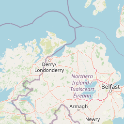
Map view of Oxford Island

Use this park location map to pinpoint Oxford Island in United Kingdom, understand its exact geographic position, and read its mapped placement within the surrounding landscape more clearly.

Pigeon | © OpenStreetMap contributors

Location context for Oxford Island

Northern Ireland
Park atlas

Compare nearby regional reserves and connected wetland habitats

Exploring Parks Near Oxford Island and Surrounding Protected Areas

Browse protected areas and wetland reserves located near Oxford Island to compare regional lowland landscapes and freshwater habitats. Examining adjacent conservation sites provides deeper geographic context for understanding the broader ecosystem surrounding Lough Neagh.
Nature reserveNorthern Ireland
About 35 km away#1 closest

North

Lough Beg Nature Reserve: Mapping the Wetlands and Floodplains of Northern Ireland

An essential protected landscape within the Lough Neagh basin.

Lough Beg provides a distinct geographic study of freshwater ecosystems and alluvial landscapes. As a designated nature reserve, it forms a crucial link in the Lower Bann catchment, characterized by its shallow waters and seasonal pasture flooding. The area serves as a primary hub for migratory bird species, while the historic Church Island offers a unique convergence of early Christian heritage and natural wetland terrain.

Relief
Lowland
Climate
Temperate
Access
Easy access
Scope
Terrestrial
Nature reserveNorthern Ireland
About 40 km away#2 closest

Northwest

Ballynahone Bog: Northern Ireland Lowland Raised Peatland and Wetland Geography

Intact active bog dome and protected wetland landscape

Examine the geography of Ballynahone Bog, one of the largest remaining lowland raised bogs in Northern Ireland. This protected landscape preserves an active peat-forming surface, intricate hummock and pool complexes, and marginal fen habitats, offering insight into the ecological history and hydrological patterns of the Lough Neagh lowland region.

Area
2.432 km²
Established
1995
Relief
Lowland
Climate
Temperate
Watercolor painting of soft, rolling green hills and dunes with purple mountain peaks in the distance against a white background.
Nature reserveCounty Down
About 44 km away#3 closest

Southeast

Murlough Nature Reserve: Coastal Dune and Heathland Atlas of County Down

A historic protected peninsula along the shores of Dundrum Bay.

Located in County Down, Murlough Nature Reserve stands as the largest dune heathland in Ireland. This protected landscape encompasses a complex system of sand dunes and open heath, set against the backdrop of the Mourne Mountains. The reserve provides a unique vantage point for understanding coastal geomorphology, invertebrate-rich habitats, and the long-term interaction between shoreline dunes and upland mountainous geography.

Area
2.82 km²
Established
1967
Relief
Lowland
Climate
Temperate
Protected areaCounty Antrim
About 62 km away#4 closest

North

Slieveanorra Forest Protected Area: Geography, Maps, and Upland Landscape Context

A comprehensive look at the Antrim forest and glacial landscape.

Slieveanorra Forest serves as a prominent protected area within the County Antrim uplands. Featuring expansive conifer woodlands, the site includes rugged terrain, reservoir edges, and scenic summit views. Understand the geological and environmental composition of this working forest landscape through its mapped boundaries and regional context.

Relief
Upland
Water
Minor water
Nature reserveCounty Fermanagh
About 78 km away#5 closest

Southwest

Crom Estate Nature Reserve and Upper Lough Erne Geographic Landscape Overview

Riparian forest and island geography in County Fermanagh

Deeply connected to the shores of Upper Lough Erne, Crom Estate is a sprawling nature reserve defined by its ancient riparian woodlands and intricate maze of bays and islands. The terrain preserves a distinct mix of old-growth forest, open grassland, and historic castle ruins, providing a valuable case study in the regional geography of County Fermanagh and the conservation of water-influenced ecosystems.

Area
5.5 km²
Established
1987
Relief
Lowland
Climate
Temperate
Nature reserveCounty Londonderry
About 79 km away#6 closest

Northwest

Roe Estuary Nature Reserve: Coastal Geography and Protected Estuarine Landscapes

Lough Foyle coastal terrain in County Londonderry

Explore the structured geography of Roe Estuary Nature Reserve, a primary coastal protected area in County Londonderry. This atlas entry details the reserve's intertidal mudflats, salt marshes, and riverine channels. Understand its unique position between the Binevenagh escarpment and the waters of Lough Foyle, highlighting its role as a vital corridor for migratory species and aquatic life within the Northern Ireland coastal landscape.

Relief
Lowland
Climate
Temperate
Access
Access unknown
Scope
Mixed
Protected areaCounty Antrim
About 85 km away#7 closest

North

Benbane Head Protected Area: Geographic Profile and Regional Landscape Mapping

Coastal terrain and protected boundaries in County Antrim

Examine the geographic characteristics of Benbane Head, a significant protected area located in County Antrim. This profile highlights the site's physical boundaries and its place within the regional landscape, providing essential mapping context for understanding Northern Ireland's diverse natural terrain and conservation geography.

Area
0.052 km²
Established
1953
Relief
Lowland
Climate
Temperate
An illustration of a green meadow in the foreground with forest, steep cliffs, and a narrow waterfall in the background under a pale sky with soft pink clouds.
National parkCounty Meath
About 87 km away#8 closest

South

Boyne Valley National Park: Protected River Floodplains and Neolithic Landscapes

Geographic atlas overview for County Meath, Ireland

Boyne Valley National Park encompasses a significant riparian corridor along the River Boyne, serving as a sanctuary for diverse freshwater species and a guardian of major megalithic monuments. This protected area offers insight into the confluence of Irish ecological preservation and prehistoric archaeological heritage within a managed, low-lying floodplain setting.

Area
2.23 km²
Established
2023
IUCN
II
Relief
Lowland

Common questions about visiting, size, designation, and location context for Oxford Island

Oxford Island FAQs for park facts, access, geography, and protected area context

Find quick answers about Oxford Island, including protected-area facts, park geography, trail and visitor context, and how the park fits into its surrounding country and regional landscape.
MoriAtlas Explorer

Continue Your Protected Areas Search Across the Global Atlas

Deepen your exploration by continuing the structured search for national parks and protected areas worldwide. Utilize the comprehensive filtering capabilities to compare different conservation landscapes and refine your understanding of global park geography. Discover more about the distribution and characteristics of protected natural areas.

Global natural geography