Mori Atlas logo
Nature reserveLough Beg

Understanding the hydrological significance and floodplain terrain of this essential Northern Ireland wetland.

Lough Beg National Nature Reserve: Geographic Context and Protected Wetland Landscape Mapping

Lough Beg sits as a critical freshwater basin within the Lough Neagh wetland system in Northern Ireland. This protected landscape is defined by its low lying alluvial floodplains and the seasonal movement of water through the Lower Bann river. The reserve represents a mosaic of wet meadows and marshy terrain, acting as a vital corridor for migratory waterbirds and preserving unique archaeological sites like Church Island within its shifting shoreline boundaries.

freshwater lakewetlandRamsar siteNational Nature Reservemigratory waterbirdsbirdwatching

Lough Beg

Nature reserve

Park overview

Structured park overview, official facts, and landscape profile for Lough Beg

Lough Beg park facts, protected area profile, and essential visitor context

Review the core facts for Lough Beg, including designation, size, terrain, visitor scale, habitats, and operating context in one park-focused overview.

About Lough Beg

Lough Beg is a compact freshwater lake set amid flat, low-lying country in the heart of Northern Ireland, immediately north of the much larger Lough Neagh. Its position, on the boundary between County Londonderry and County Antrim, places it within one of the most important wetland landscapes in the British Isles. Although small in comparison with its neighbour, Lough Beg is not an isolated waterbody: it is integral to the hydrology of the Lower Bann system, receiving the outflow of Lough Neagh at its southern end and passing it northwards on the river's journey to the Atlantic.

The lake is shallow, and its margins blend gradually into surrounding wet grassland, marsh, and seasonally flooded fields. These fringing habitats give the site a much broader ecological footprint than the open water alone would suggest, creating a mosaic of shallow water, reedbed, fen, and damp pasture that supports a wide range of plants and animals. Because the water levels in the lake fell measurably following major dredging of the Bann in the 1930s, parts of what were once true islands, including Church Island, are now usually accessible on foot, reshaping how visitors and pilgrims experience the place.

Lough Beg's identity rests on two reinforcing pillars. The first is its ecological value as a wetland of international stature, reflected in its inclusion within the Lough Neagh and Lough Beg Ramsar site and its designation as a National Nature Reserve. The second is its cultural and historical depth, anchored by Church Island and its early monastic remains, and by a continuing pattern of seasonal pilgrimage and traditional land use such as cattle grazing on the wetland margins.

Quick facts and research context for Lough Beg

Lough Beg is a small freshwater lake in central Northern Ireland, separated geographically but hydrologically connected to the much larger Lough Neagh to the south. It lies on the border between County Londonderry and County Antrim and is drained by the Lower Bann, which links Lough Neagh's outflow to the north coast.

The lake and its fringing wetlands are internationally recognised: Lough Neagh and Lough Beg were jointly designated as a Ramsar wetland site in January 1976. The area is managed as a National Nature Reserve because of its combination of floodplain, marsh, and seasonal grazing habitats, and because it regularly supports large numbers of migratory and breeding waterbirds.

Protection and recognition

Documented terrestrial conservation scope and recognition records

Lough Beg Protection Status and Official Designation History

Lough Beg maintains a documented terrestrial protection status established in 1976. Conservation records outline the official designation history and management framework associated with the landscape.

Protection details

Protection scope
Terrestrial
Designated year
1976
Transboundary protection
No
Park context

Deeper park guide and search-rich context for Lough Beg

Lough Beg history, landscape, wildlife, and travel context

Explore Lough Beg through its history, landscape character, ecosystems, wildlife, conservation priorities, cultural context, and seasonal travel timing in a structured park guide built for atlas discovery and search intent.

Why Lough Beg stands out

Lough Beg is best known internationally as part of the Lough Neagh and Lough Beg Ramsar wetland, valued for its importance to migratory swans, geese, and ducks. It is also notable as one of the principal breeding areas in Ireland for the scarce Garganey, a small dabbling duck that is a localised summer visitor. Locally and culturally, Lough Beg is associated with Church Island, an almost-island site linked to early monastic tradition and to the landscape of the Bellaghy area. The combination of significant bird and plant interest with a striking early Christian heritage site distinguishes it from purely ecological wetlands elsewhere in Ireland.
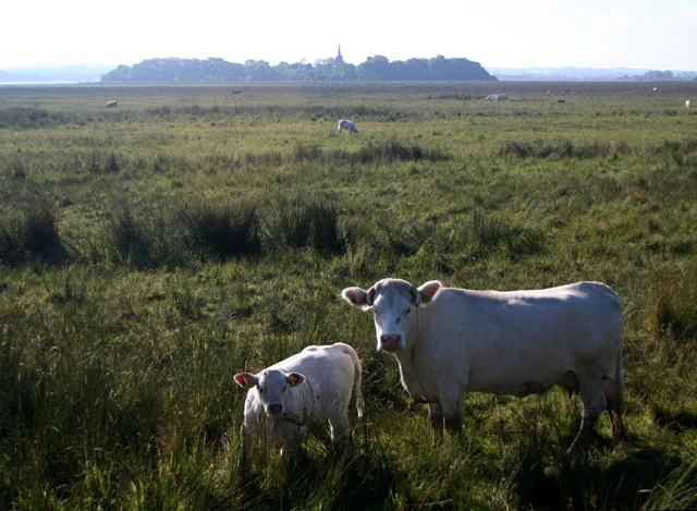
Two light-colored cattle standing in a grassy meadow, with a low-lying island featuring a small church spire visible on the horizon.
Cattle grazing in the Lough Beg nature reserve, with the landmark Church Island visible in the distance.

Lough Beg history and protected-area timeline

The earliest layer of Lough Beg's history is bound up with the early Christian period. Church Island, set within the lake, is traditionally associated with Saint Patrick and the time when Christianity was being established across Ulster through riverine travel; a monastic settlement is said to have been founded here, and the site has long been linked to Saint Thaddeus, whose feast is still marked by an annual pilgrimage on the first Sunday in September. The surviving church on the island is reputed to date back to this era, although it was later modified in the eighteenth century when a separate freestanding spire was erected beside it so that Bishop Harvey could see it from his home at Bellaghy.

A second, more recent chapter in the lake's history is environmental and infrastructural. The dredging of the River Bann in the 1930s lowered water levels across the wider Lough Neagh system, reducing the lake's depth and effectively turning Church Island from a true island into one that is normally reached on foot. The hollowed Bullaun Stone on the island, attributed by tradition to the prayers of Saint Patrick, remains a focus of interest for visitors.

The modern protected status of Lough Beg was formalised in the second half of the twentieth century. Lough Neagh and Lough Beg were jointly designated as a Ramsar wetland site on 5 January 1976, recognising the area's international importance for waterbirds and its wetland habitats. This international recognition complemented national-level protection through the establishment of the Lough Beg National Nature Reserve, securing the future of a landscape shaped by both natural processes and centuries of human presence.

Lough Beg landscape and geographic character

Lough Beg occupies a low-lying basin landscape characteristic of the Lough Neagh lowlands. The terrain around the lake is gentle and flat, dominated by alluvial floodplain rather than hills or rocky shores, and the lake itself is shallow rather than deep. The visual impression is of a calm, open sheet of water fringed by soft edges of marsh, wet meadow, and grazing land rather than cliffs or headlands.

The single most distinctive feature of the lake's setting is Church Island, sitting low in the water near the shore. Because the lake's level dropped after the River Bann was dredged in the 1930s, Church Island now rises only marginally above the surrounding ground and is usually reached on foot across damp ground rather than by boat. A short distance away on the shore is the village of Bellaghy, which gives the site its local landmark and historical reference point.

Hydrologically, the landscape is defined by the Lower Bann, which links Lough Beg to both Lough Neagh upstream and the northern coast downstream. This through-flowing water, combined with seasonal flooding of the surrounding pasture, creates a shifting mosaic of wet and drier ground across the year, with the lake acting as both a reservoir and a passage for water moving through central Ulster.

Lough Beg ecosystems, habitats, and plant life

The ecological character of Lough Beg is defined by its position within the Lough Neagh wetland complex. The lake itself is freshwater and relatively shallow, and its margins grade into a network of wetlands that includes open water, reedbed, marsh, and seasonally flooded grassland. Because water levels fluctuate with the seasons and with management of the Bann, the boundary between lake and land is not fixed, and habitats shift in extent from year to year.

A significant part of the area's natural value lies in its plant life, particularly in the wet meadows and fen vegetation along the lake margins. The Lough Neagh basin is one of the very few parts of Ireland in which the hooded lady's tresses orchid occurs, giving the area a botanical importance that goes beyond the more obvious waterbird interest. The mix of wet pasture, marsh, and open water also supports a wide range of aquatic and semi-aquatic plant communities.

Beyond plants, the habitats support a rich invertebrate fauna typical of nutrient-rich lowland wetlands, which in turn underpins the area's importance for birds and other wildlife. Traditional land uses, notably low-intensity cattle grazing on the surrounding wet grassland, continue to play a role in maintaining the open, herb-rich character of the wetland margins.

Lough Beg wildlife and species highlights

Lough Beg's wildlife profile is overwhelmingly shaped by its value to birds, especially waterbirds that use the lake and its associated marshes and floodplains. The site regularly hosts large numbers of swans, geese, and ducks, drawn by the combination of open water, shallow feeding areas, and surrounding wet pasture. Its role as a staging point on migration routes gives it significance well beyond its local context, and underpins its joint designation with Lough Neagh as a Ramsar wetland.

The lake is particularly notable for its breeding birds. It is one of the main breeding areas in Ireland for the Garganey, a small dabbling duck that is a scarce and localised summer visitor to these islands. The presence of regular Garganey breeding, alongside more widespread species, gives the site an ornithological profile that is distinctive within the Irish context.

Mammals and other groups are less prominent in the site's recorded profile, but the richness of the wetland habitats, with their mosaic of water, marsh, and grazed pasture, supports a typical range of wetland-associated fauna for a lowland lake of this kind.

Lough Beg conservation status and protection priorities

Conservation at Lough Beg operates at several overlapping levels. On the international stage, Lough Neagh and Lough Beg were together designated as a Ramsar site in 1976, recognising the area as a wetland of international importance, particularly for its waterbirds and its ecological character. This designation commits the site to long-term wise-use principles and places it within a global network of significant wetlands.

At the national level, the area is protected as the Lough Beg National Nature Reserve, with management focused on maintaining the habitats that give the site its value: open water, reedbed, marsh, and grazed wet grassland. The retention of low-intensity grazing on surrounding pasture is itself part of the conservation strategy, because it helps to keep the wetland margins open and botanically rich.

Beyond formal designations, the conservation significance of Lough Beg lies in its function as a refuge and waypoint for migratory waterbirds within the wider Lough Neagh catchment. In a landscape where wetlands have been extensively altered, the persistence here of a contiguous mosaic of lake, marsh, and floodplain gives the area continuing ecological importance for both resident and migratory species.

Lough Beg cultural meaning and human context

Lough Beg's cultural identity is closely woven into that of the surrounding countryside in south County Londonderry, particularly around the village of Bellaghy. The lake has long been part of the everyday life of this rural community, both as a working landscape of grazing and fishing and as a setting for traditional gatherings.

The most visible cultural landmark is Church Island, with its reputed early Christian monastery linked to Saint Patrick and Saint Thaddeus. The island's church, its eighteenth-century freestanding spire (built so that Bishop Harvey could see it from Bellaghy), and the Bullaun Stone, said to have been hollowed by the saint's prayers, together form a heritage focus that draws a regular pilgrimage on the first Sunday in September each year.

The lowering of the lake after the 1930s dredging of the Bann changed the practical relationship between people and the lake: Church Island is no longer crossed by boat in summer, but walked to across damp ground. This shift has, if anything, deepened the integration of the monastic site into the everyday rounds of the surrounding farmland and village life.

Top sights and standout views in Lough Beg

Lough Beg's strongest features are the international importance of its wetland, embodied in its Ramsar designation alongside Lough Neagh; its status as one of Ireland's principal breeding sites for the scarce Garganey; and the presence of Church Island, with its reputed Saint Patrick-era monastery, freestanding spire, and the Bullaun Stone that still draws an annual pilgrimage. The combination of a nationally protected wetland with an early Christian heritage island, set in a low-lying pastoral landscape drained by the Lower Bann, gives the lake a layered character unusual for a waterbody of its size.

Best time to visit Lough Beg

The character of a visit to Lough Beg shifts with the seasons in ways that reflect the lake's dual natural and cultural rhythms. Spring and autumn are typically the most productive periods for birdwatching, as the lake acts as a staging point for migratory swans, geese, and ducks passing through the Lough Neagh system, while the surrounding marshes fill with movement.

Summer brings calmer water, fuller wetland vegetation, and the best chance to walk out to Church Island on foot, as well as the breeding season during which the area's Garganey are present. The annual pilgrimage to Church Island on the first Sunday in September offers a distinctive cultural focal point at the transition into autumn, when migrant birds are again on the move and the surrounding pastures carry the marks of low-intensity grazing that helps maintain the wetland habitats.
Monthly climate preview

Long-term representative averages tracking weather by month across the protected landscape

Lough Beg Climate Normals, Annual Temperature and Precipitation Rhythm

Representative coordinates record measured annual temperature fluctuations alongside monthly precipitation totals from NASA climatology data. Examining the complete twelve-month record reveals broader climatic patterns across the protected landscape.
Annual mean9 °C
5 °C14 °C
Jan
Feb
Mar
Apr
May10°
Jun13°
Jul14°
Aug14°
Sep13°
Oct10°
Nov
Dec
Warmest month
August

14.3 °C

Coolest month
January

5.1 °C

Wettest month
November

3.9 mm/day

Driest month
May

2.4 mm/day

Park location guide

Geography guide, regional context, and park location map for Lough Beg

Lough Beg park geography, regions, and map view in United Kingdom

Understand where Lough Beg sits in United Kingdom through a broader geographic reading of the surrounding landscape, nearby location context, and its mapped position within the national park landscape.

How Lough Beg fits into United Kingdom

The United Kingdom is a parliamentary constitutional monarchy located in northwestern Europe, consisting of four constituent countries: England, Scotland, Wales, and Northern Ireland. As a major global power with over 69 million residents, it maintains significant international influence in politics, economics, and culture.

Wider geography shaping Lough Beg in United Kingdom

The United Kingdom is an island nation located in northwestern Europe, surrounded by the Atlantic Ocean, North Sea, English Channel, Celtic Sea, and Irish Sea. It shares a land border with the Republic of Ireland to the west. The territory includes the island of Great Britain, the northeastern portion of Ireland, and most of the smaller British Isles islands.

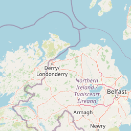
Map view of Lough Beg

Use this park location map to pinpoint Lough Beg in United Kingdom, understand its exact geographic position, and read its mapped placement within the surrounding landscape more clearly.

Pigeon | © OpenStreetMap contributors

Location context for Lough Beg

Northern Ireland

Explore detailed imagery of floodplain habitats, seasonal marshes, and Church Island heritage.

Lough Beg Photos and Protected Wetland Scenery: Visualizing the Lowland Basin

Visual documentation captures the flat alluvial basin, shallow freshwater lake, and wet meadows defining the protected reserve. Examining these photographic records reveals the distinct ecological character and open wetland terrain of the Northern Ireland landscape.

Two light-colored cattle standing in a grassy meadow, with a low-lying island featuring a small church spire visible on the horizon.

Park atlas

Compare adjacent wetland reserves, basin terrain, and regional floodplain habitats

Explore Protected Areas and Parks Near Lough Beg in Northern Ireland

Browsing other protected areas near Lough Beg reveals connected wetland ecosystems and lowland river basins across the surrounding region. Comparing these complementary habitats provides broader geographic context for the freshwater reserves and regional bird migration routes of central Ulster.
Nature reserveNorthern Ireland
About 11 km away#1 closest

West

Ballynahone Bog: Northern Ireland Lowland Raised Peatland and Wetland Geography

Intact active bog dome and protected wetland landscape

Examine the geography of Ballynahone Bog, one of the largest remaining lowland raised bogs in Northern Ireland. This protected landscape preserves an active peat-forming surface, intricate hummock and pool complexes, and marginal fen habitats, offering insight into the ecological history and hydrological patterns of the Lough Neagh lowland region.

Area
2.432 km²
Established
1995
Relief
Lowland
Climate
Temperate
Protected areaCounty Antrim
About 32 km away#2 closest

Northeast

Slieveanorra Forest Protected Area: Geography, Maps, and Upland Landscape Context

A comprehensive look at the Antrim forest and glacial landscape.

Slieveanorra Forest serves as a prominent protected area within the County Antrim uplands. Featuring expansive conifer woodlands, the site includes rugged terrain, reservoir edges, and scenic summit views. Understand the geological and environmental composition of this working forest landscape through its mapped boundaries and regional context.

Relief
Upland
Water
Minor water
Nature reserveNorthern Ireland
About 35 km away#3 closest

South

Oxford Island National Nature Reserve: Protected Wetland Landscapes of Northern Ireland

Lakeshore habitats and woodland geography at Lough Neagh

Oxford Island is a prominent nature reserve where terrestrial woodland meets the expansive waters of Lough Neagh. The site showcases a transition of reed beds and meadows that serve as vital ecological assets within the regional geography of Northern Ireland, offering a dense, accessible look at lowland wetland environments.

Area
1.14 km²
Relief
Lowland
Climate
Temperate
Access
Easy access
Nature reserveCounty Londonderry
About 48 km away#4 closest

Northwest

Roe Estuary Nature Reserve: Coastal Geography and Protected Estuarine Landscapes

Lough Foyle coastal terrain in County Londonderry

Explore the structured geography of Roe Estuary Nature Reserve, a primary coastal protected area in County Londonderry. This atlas entry details the reserve's intertidal mudflats, salt marshes, and riverine channels. Understand its unique position between the Binevenagh escarpment and the waters of Lough Foyle, highlighting its role as a vital corridor for migratory species and aquatic life within the Northern Ireland coastal landscape.

Relief
Lowland
Climate
Temperate
Access
Access unknown
Scope
Mixed
Protected areaCounty Antrim
About 50 km away#5 closest

North

Benbane Head Protected Area: Geographic Profile and Regional Landscape Mapping

Coastal terrain and protected boundaries in County Antrim

Examine the geographic characteristics of Benbane Head, a significant protected area located in County Antrim. This profile highlights the site's physical boundaries and its place within the regional landscape, providing essential mapping context for understanding Northern Ireland's diverse natural terrain and conservation geography.

Area
0.052 km²
Established
1953
Relief
Lowland
Climate
Temperate
Watercolor painting of soft, rolling green hills and dunes with purple mountain peaks in the distance against a white background.
Nature reserveCounty Down
About 75 km away#6 closest

Southeast

Murlough Nature Reserve: Coastal Dune and Heathland Atlas of County Down

A historic protected peninsula along the shores of Dundrum Bay.

Located in County Down, Murlough Nature Reserve stands as the largest dune heathland in Ireland. This protected landscape encompasses a complex system of sand dunes and open heath, set against the backdrop of the Mourne Mountains. The reserve provides a unique vantage point for understanding coastal geomorphology, invertebrate-rich habitats, and the long-term interaction between shoreline dunes and upland mountainous geography.

Area
2.82 km²
Established
1967
Relief
Lowland
Climate
Temperate
Protected landscapeCounty Fermanagh
About 89 km away#7 closest

Southwest

Castle Archdale Protected Landscape in County Fermanagh: Geography and Map Overview

Lakeside woodland and historic terrain on Lower Lough Erne

Located on the shores of Lower Lough Erne, Castle Archdale represents a unique protected landscape in County Fermanagh. The area features a complex mosaic of sheltered inlets, mature woodland, and open parkland that characterises the Fermanagh lakelands. Beyond its physical terrain, the site is defined by its historical significance, from seventeenth century estate remnants to its role as a pivotal wartime flying boat base, providing a rich context for geographic and environmental exploration.

Relief
Lowland
Climate
Temperate
Access
Easy access
Scope
Terrestrial
Watercolor illustration of a mountainous landscape with a lake and forests
National parkCounty Donegal
About 94 km away#8 closest

West

Glenveagh National Park: A Protected Landscape in the Heart of County Donegal

Mapped geography and natural terrain for Ireland's national park.

Delve into the geographic specifics of Glenveagh National Park, a protected area situated in County Donegal. This section provides detailed information on its mapped boundaries and regional landscape context. Understand how this national park fits within the natural geography of Ulster, offering a structured atlas view for detailed exploration of its unique terrain and protected status.

Area
169.58 km²
Established
1986
IUCN
II
Relief
Mixed relief

Common questions about visiting, size, designation, and location context for Lough Beg

Lough Beg FAQs for park facts, access, geography, and protected area context

Find quick answers about Lough Beg, including protected-area facts, park geography, trail and visitor context, and how the park fits into its surrounding country and regional landscape.
MoriAtlas Explorer

Continue Your Protected Areas Search Across the Global Atlas

Deepen your exploration by continuing the structured search for national parks and protected areas worldwide. Utilize the comprehensive filtering capabilities to compare different conservation landscapes and refine your understanding of global park geography. Discover more about the distribution and characteristics of protected natural areas.

Global natural geography