Mori Atlas logo
Nature reserveBallynahone Bog

A rare intact raised bog dome featuring distinct hummock and pool micro-topography

Ballynahone Bog: Examining the Geography and Protected Landscapes of Northern Ireland

Ballynahone Bog represents a critical lowland raised peatland in Northern Ireland, distinguished by its active peat-forming surface and intact domed structure. Located on low-lying ground north of the Moyola River, this protected wetland provides a vital record of undisturbed bog hydrology. The landscape integrates complex surface patterns with marginal birch woodland and fen areas, offering a clear view into the regional ecology of the Lough Neagh basin.

raised bogpeatlandwetlandlowland bogRamsar siteArea of Special Scientific Interest

Ballynahone Bog

Nature reserve

Park overview

Structured park overview, official facts, and landscape profile for Ballynahone Bog

Ballynahone Bog park facts, protected area profile, and essential visitor context

Review the core facts for Ballynahone Bog, including designation, size, terrain, visitor scale, habitats, and operating context in one park-focused overview.

About Ballynahone Bog

Ballynahone Bog is a lowland raised bog in County Londonderry, Northern Ireland, located on flat ground immediately north of the Moyola River, around three kilometres south of Maghera. It is part of the wider Lough Neagh lowlands, where peatland formation has shaped the countryside for thousands of years, producing a mosaic of raised bogs, fens, woodland margins, and former cut-over areas. Of these landscapes, Ballynahone represents one of the most intact examples still remaining, with much of its domed peat surface still undamaged and ecologically functional.

The defining feature of Ballynahone is its raised bog dome, a gently domed mass of peat that has accumulated over centuries and continues to support peat-forming vegetation. The surface displays the classic micro-topography of healthy raised bog, including bog pools and elevated peat hummocks, surrounded by an outer fringe of cut-over bog, areas of poor fen, and birch woodland. This combination of intact core habitat and environmental gradients gives the site substantial ecological value beyond the bog itself.

The site is particularly significant at the national and international levels because it is one of two large active raised bogs still surviving in Northern Ireland. Following decades of peat extraction across the region, surviving raised bogs have become increasingly rare, and Ballynahone is regarded as a representative example of the habitat type on a UK-wide scale. Its recognition under the Ramsar Convention reflects not just its size but its ecological quality, with characteristic vegetation structure and species composition still largely intact.

Beyond its ecological value, Ballynahone also represents an important moment in the modern history of wetland conservation in Northern Ireland. The protection of the site was the result of a prolonged campaign by local volunteers who opposed large-scale commercial peat extraction and helped secure permanent legal safeguards for the bog. Today, the site functions both as a refuge for bog-specialist flora and fauna and as a reference point for understanding the conservation of lowland peatlands across these islands.

Quick facts and research context for Ballynahone Bog

Ballynahone Bog is a lowland raised bog in County Londonderry, Northern Ireland, covering an area of roughly 243 hectares. It lies near the Moyola River on the western side of the Lough Neagh lowlands, in a region historically dominated by peatland landscapes that have been heavily modified by drainage and turf cutting.

The site is internationally recognised as a Ramsar wetland and is also designated as an Area of Special Scientific Interest, reflecting its exceptional representation of intact raised bog within the United Kingdom. It is regarded as one of the two largest intact active bogs remaining in Northern Ireland, with characteristic hummock and pool topography and surrounding birch woodland and poor fen vegetation.

Protection and recognition

Terrestrial protected area designation history and official recognition records

Ballynahone Bog Protection Status and International Recognition Data

Ballynahone Bog maintains documented terrestrial protection status established in 1998 alongside official Natura 2000 and Ramsar designations. Structured conservation records outline the baseline international recognition framework associated with this protected landscape.

International recognition

Protection details

Protection scope
Terrestrial
Designated year
1998
Transboundary protection
No
Park context

Deeper park guide and search-rich context for Ballynahone Bog

Ballynahone Bog history, landscape, wildlife, and travel context

Explore Ballynahone Bog through its history, landscape character, ecosystems, wildlife, conservation priorities, cultural context, and seasonal travel timing in a structured park guide built for atlas discovery and search intent.

Why Ballynahone Bog stands out

Ballynahone Bog is best known for being one of the best-preserved lowland raised bogs in the United Kingdom, with an active domed peat surface, well-developed hummock and pool patterns, and a high proportion of bog-specialist plant communities. Its importance is widely recognised through its designation as both a Ramsar site and an Area of Special Scientific Interest, partly because so few large raised bogs in this region remain intact after decades of peat extraction. The site also stands out as a landmark case in Northern Irish conservation, representing a successful community-driven effort to halt commercial peat extraction and secure long-term legal protection for a vulnerable wetland habitat.

Ballynahone Bog history and protected-area timeline

The modern conservation history of Ballynahone Bog is closely tied to the conflict between commercial peat extraction and community-led protection efforts that unfolded across several decades. The site first drew industrial attention in 1979, when a horticultural peat producer established a factory with government assistance and began leasing bogs in the surrounding townlands. By the late 1980s, planning applications had expanded to include extensive peat milling operations across Ballynahone, Mullagh, and Knocnakielt, raising serious concerns about the future of the intact bog.

In 1988, despite local objections, planning permission for peat extraction was granted by the Department of the Environment in Northern Ireland. The decision triggered an organised public response. In 1990, the Ulster Wildlife Trust issued a widely circulated press release inviting members to take what was framed as a final walk on an Ulster bog, assuming the fight to protect ancient bog flora and fauna had already been lost. The response drew significant public interest, leading to public meetings and the formal founding of the Friends of the Ballynahone Bog (FBB) as a grassroots conservation group.

By 1991, the peat company had dug approximately 13 miles of drainage channels across the southern half of Ballynahone Bog, threatening the hydrology that maintained the raised dome. In 1993, FBB began the formal process of pursuing National Nature Reserve designation, and after pressure from environmental figures including Professor David Bellamy and Friends of the Earth, planning permission was revoked and the government signalled its intent to designate the site as an Area of Special Scientific Interest.

In December 1993, the peat company dammed much of the drainage network with around 1,700 small dams, helping to restore water levels in the bog. In January 1995, Ballynahone Bog was officially declared an ASSI, marking the legal recognition of its scientific and conservation value. The site subsequently gained international recognition, with Ramsar designation granted on 31 December 1998. Today, FBB continues to work in partnership with the Ulster Wildlife Trust on habitat restoration, particularly focused on hydrological recovery and the revival of bog-specialist plants and the wildlife that depends on them.

Ballynahone Bog landscape and geographic character

Ballynahone Bog occupies a flat, low-lying stretch of terrain in County Londonderry, part of the broader lowland basin that surrounds Lough Neagh, the largest lake in the British Isles. The site lies directly north of the Moyola River, which drains into Lough Neagh roughly 14 kilometres downstream, and the surrounding topography is shaped by long-standing peatland processes rather than dramatic relief.

The central feature of the landscape is the raised bog dome itself: a gently convex mass of accumulated peat, rising slightly above the surrounding land. This dome supports the classic micro-topography of a healthy raised bog, including shallow bog pools and raised peat hummocks that form intricate patterns across the surface. Around the active dome lies a fringe of cut-over bog, where peat has historically been removed, alongside patches of poor fen vegetation and birch woodland at the bog margins.

Together, the raised dome, the surrounding cut-over areas, and the birch and fen fringes create a layered wetland landscape in which hydrology controls nearly every feature. Even small changes in water table depth can alter the balance between active bog, transitional fen, and marginal woodland, making the broader landscape of Ballynahone both visually subtle and ecologically dynamic.

Ballynahone Bog ecosystems, habitats, and plant life

The habitat character of Ballynahone is defined by the ecology of a lowland raised bog, a type of peatland built up over millennia through the slow accumulation of partially decayed plant matter under waterlogged conditions. The central dome remains active, with peat formation still occurring, while the surrounding areas reflect different stages of influence, recovery, and historic disturbance.

Sphagnum mosses dominate the bog surface, forming the principal peat-forming vegetation and giving the site its characteristic water-holding sponge-like structure. Among the sphagnum cover, ericoid dwarf-shrubs such as cross-leaved heath and heather form a key layer of the vegetation, accompanied by specialist bog plants including hare's-tail cottongrass, common cottongrass, deergrass, and sundews. The site also supports bog asphodel, white beak-sedge, and localised patches of bog-myrtle, all of which are strongly associated with healthy, hydrologically intact peatland.

Around the active bog, the vegetation transitions into poor fen and birch woodland along the margins, where mineral enrichment increases and peat accumulation slows. These transitional zones add habitat diversity and help buffer the core bog from surrounding land use. The combination of intact active bog, recovering cut-over areas, fringing fen, and marginal woodland gives Ballynahone rich ecological structure relative to many other peatland sites in the region.

Ballynahone Bog wildlife and species highlights

Ballynahone's wildlife profile is shaped by the specialised conditions of an active raised bog, where low nutrient availability, acidic peat, and consistently high moisture levels create a distinctive environment for plants and animals. Although the site's faunal communities are less frequently catalogued than its flora, conservation efforts at Ballynahone have emphasised the importance of the bog habitat for invertebrates and birdlife that depend on bog-specific plants and hydrological conditions.

The presence of insect-dependent plants such as sundews reflects the abundance of small invertebrate life that thrives on the bog surface. Restoration work by the Friends of Ballynahone Bog and the Ulster Wildlife Trust has aimed in part at supporting the recovery of these invertebrate communities, recognising their foundational role in the wider bog food web. Birds associated with open bog, bog pools, and adjacent birch woodland also benefit from the site's intact condition and the mosaic of habitats across the dome, the cut-over areas, and the fringing woodland.

The wildlife significance of Ballynahone is therefore closely tied to its plants: protecting the hydrology and the bog-specialist flora is treated as the central conservation goal, with the understanding that doing so also supports the broader community of invertebrates, birds, and other fauna that depend on these delicate peatland conditions.

Ballynahone Bog conservation status and protection priorities

Ballynahone Bog holds substantial conservation importance at regional, national, and international scales. As a Ramsar-designated wetland of international importance since 31 December 1998, it qualifies under the convention's criterion for being a particularly good representative example of lowland raised bog, a habitat type that has declined severely across much of Europe.

At the United Kingdom level, Ballynahone is recognised as one of the best examples of its habitat type remaining, and is regarded as one of the two largest intact active bogs still found in Northern Ireland. Its designation as an Area of Special Scientific Interest adds a further layer of legal protection, requiring management that maintains the ecological character of the site.

Beyond formal designations, Ballynahone is significant because it illustrates the recovery potential of degraded raised bogs when extraction pressure is removed and hydrological conditions are restored. The site's continued protection depends on active management of water levels, control of drainage, and ongoing collaboration between statutory bodies and the local conservation group that played a defining role in securing the bog's future.

Ballynahone Bog cultural meaning and human context

The cultural significance of Ballynahone Bog is closely tied to the long-standing rural relationship between local communities and peatland landscapes in Northern Ireland, where small-scale turf cutting and, in the modern era, industrial peat extraction have both shaped and threatened these habitats. The bog lies near Maghera in County Londonderry, an area with deep rural and agricultural traditions connected to the surrounding lowlands.

The name Ballynahone itself derives from the Irish Baile na hAbhann, meaning 'townland of the river', reflecting the long-standing connection of the area to the Moyola River and its floodplain. The site's more recent history is also culturally important: the Friends of the Ballynahone Bog emerged from local community action in the early 1990s and helped define a more contemporary culture of grassroots wetland conservation in Northern Ireland, marking Ballynahone as a landmark site in the region's environmental heritage.

Top sights and standout views in Ballynahone Bog

Ballynahone Bog stands out for the exceptional condition of its raised bog dome, which retains an active peat-forming surface, well-developed hummock and pool patterns, and a high cover of sphagnum mosses alongside classic bog-specialist plants. It is one of the two largest intact active raised bogs still surviving in Northern Ireland and is recognised internationally as one of the best UK examples of its habitat type.

Equally notable is the site's role as a conservation milestone: a place where persistent community campaigning, scientific advocacy, and statutory protection came together to halt commercial peat extraction and secure long-term safeguards for a wetland of significant ecological value.

Best time to visit Ballynahone Bog

Ballynahone Bog is a working peatland conservation site rather than a developed visitor destination, and seasonal conditions are best understood in terms of how they affect the bog itself. Late spring and summer generally offer the most active period for observing the bog's characteristic vegetation, when sphagnum mosses, cottongrasses, heathers, and sundews are most visible and the wetland is in its most biologically expressive state.

Autumn brings warmer tones across the ericoid vegetation and quieter conditions, while winter can expose the subtle topography of the bog dome more clearly, with frost and pooled water highlighting the hummock and pool structure. Access is shaped by conservation sensitivities rather than conventional tourism infrastructure, so any visit is best treated as a careful exploration of an ecologically sensitive peatland landscape.
Monthly climate preview

Long-term representative measurements illustrating monthly weather patterns and temperature ranges

Ballynahone Bog Climate Normals: Annual Temperature and Precipitation Rhythm

Ballynahone Bog exhibits measured long-term temperature and precipitation cycles across a representative coordinate spanning monthly averages from negative to moderate values. Reviewing the complete twelve-month climatological profile provides detailed insight into annual environmental rhythms and thermal variations.
Annual mean9 °C
5 °C14 °C
Jan
Feb
Mar
Apr
May10°
Jun13°
Jul14°
Aug14°
Sep12°
Oct10°
Nov
Dec
Warmest month
July

14.2 °C

Coolest month
January

4.7 °C

Wettest month
November

3.9 mm/day

Driest month
May

2.5 mm/day

Park location guide

Geography guide, regional context, and park location map for Ballynahone Bog

Ballynahone Bog park geography, regions, and map view in United Kingdom

Understand where Ballynahone Bog sits in United Kingdom through a broader geographic reading of the surrounding landscape, nearby location context, and its mapped position within the national park landscape.

How Ballynahone Bog fits into United Kingdom

The United Kingdom is a parliamentary constitutional monarchy located in northwestern Europe, consisting of four constituent countries: England, Scotland, Wales, and Northern Ireland. As a major global power with over 69 million residents, it maintains significant international influence in politics, economics, and culture.

Wider geography shaping Ballynahone Bog in United Kingdom

The United Kingdom is an island nation located in northwestern Europe, surrounded by the Atlantic Ocean, North Sea, English Channel, Celtic Sea, and Irish Sea. It shares a land border with the Republic of Ireland to the west. The territory includes the island of Great Britain, the northeastern portion of Ireland, and most of the smaller British Isles islands.

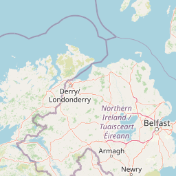
Map view of Ballynahone Bog

Use this park location map to pinpoint Ballynahone Bog in United Kingdom, understand its exact geographic position, and read its mapped placement within the surrounding landscape more clearly.

Pigeon | © OpenStreetMap contributors

Location context for Ballynahone Bog

County LondonderryNorthern Ireland
Park atlas

Compare regional wetlands, peatlands, and protected areas across the surrounding territory.

Explore Parks Near Ballynahone Bog and Connected Protected Landscapes

Browsing parks near Ballynahone Bog reveals adjacent wetland habitats and lowland protected areas across the surrounding region. Extending the geographic comparison helps trace regional peatland preservation and broader conservation patterns.
Nature reserveNorthern Ireland
About 11 km away#1 closest

East

Lough Beg Nature Reserve: Mapping the Wetlands and Floodplains of Northern Ireland

An essential protected landscape within the Lough Neagh basin.

Lough Beg provides a distinct geographic study of freshwater ecosystems and alluvial landscapes. As a designated nature reserve, it forms a crucial link in the Lower Bann catchment, characterized by its shallow waters and seasonal pasture flooding. The area serves as a primary hub for migratory bird species, while the historic Church Island offers a unique convergence of early Christian heritage and natural wetland terrain.

Relief
Lowland
Climate
Temperate
Access
Easy access
Scope
Terrestrial
Nature reserveCounty Londonderry
About 36 km away#2 closest

Northwest

Roe Estuary Nature Reserve: Coastal Geography and Protected Estuarine Landscapes

Lough Foyle coastal terrain in County Londonderry

Explore the structured geography of Roe Estuary Nature Reserve, a primary coastal protected area in County Londonderry. This atlas entry details the reserve's intertidal mudflats, salt marshes, and riverine channels. Understand its unique position between the Binevenagh escarpment and the waters of Lough Foyle, highlighting its role as a vital corridor for migratory species and aquatic life within the Northern Ireland coastal landscape.

Relief
Lowland
Climate
Temperate
Access
Access unknown
Scope
Mixed
Protected areaCounty Antrim
About 37 km away#3 closest

Northeast

Slieveanorra Forest Protected Area: Geography, Maps, and Upland Landscape Context

A comprehensive look at the Antrim forest and glacial landscape.

Slieveanorra Forest serves as a prominent protected area within the County Antrim uplands. Featuring expansive conifer woodlands, the site includes rugged terrain, reservoir edges, and scenic summit views. Understand the geological and environmental composition of this working forest landscape through its mapped boundaries and regional context.

Relief
Upland
Water
Minor water
Nature reserveNorthern Ireland
About 40 km away#4 closest

Southeast

Oxford Island National Nature Reserve: Protected Wetland Landscapes of Northern Ireland

Lakeshore habitats and woodland geography at Lough Neagh

Oxford Island is a prominent nature reserve where terrestrial woodland meets the expansive waters of Lough Neagh. The site showcases a transition of reed beds and meadows that serve as vital ecological assets within the regional geography of Northern Ireland, offering a dense, accessible look at lowland wetland environments.

Area
1.14 km²
Relief
Lowland
Climate
Temperate
Access
Easy access
Protected areaCounty Antrim
About 48 km away#5 closest

North

Benbane Head Protected Area: Geographic Profile and Regional Landscape Mapping

Coastal terrain and protected boundaries in County Antrim

Examine the geographic characteristics of Benbane Head, a significant protected area located in County Antrim. This profile highlights the site's physical boundaries and its place within the regional landscape, providing essential mapping context for understanding Northern Ireland's diverse natural terrain and conservation geography.

Area
0.052 km²
Established
1953
Relief
Lowland
Climate
Temperate
Protected landscapeCounty Fermanagh
About 78 km away#6 closest

Southwest

Castle Archdale Protected Landscape in County Fermanagh: Geography and Map Overview

Lakeside woodland and historic terrain on Lower Lough Erne

Located on the shores of Lower Lough Erne, Castle Archdale represents a unique protected landscape in County Fermanagh. The area features a complex mosaic of sheltered inlets, mature woodland, and open parkland that characterises the Fermanagh lakelands. Beyond its physical terrain, the site is defined by its historical significance, from seventeenth century estate remnants to its role as a pivotal wartime flying boat base, providing a rich context for geographic and environmental exploration.

Relief
Lowland
Climate
Temperate
Access
Easy access
Scope
Terrestrial
Watercolor illustration of a mountainous landscape with a lake and forests
National parkCounty Donegal
79 km away#7 closest

West

Glenveagh National Park: A Protected Landscape in the Heart of County Donegal

Mapped geography and natural terrain for Ireland's national park.

Delve into the geographic specifics of Glenveagh National Park, a protected area situated in County Donegal. This section provides detailed information on its mapped boundaries and regional landscape context. Understand how this national park fits within the natural geography of Ulster, offering a structured atlas view for detailed exploration of its unique terrain and protected status.

Area
169.58 km²
Established
1986
IUCN
II
Relief
Mixed relief
Watercolor painting of soft, rolling green hills and dunes with purple mountain peaks in the distance against a white background.
Nature reserveCounty Down
About 83 km away#8 closest

Southeast

Murlough Nature Reserve: Coastal Dune and Heathland Atlas of County Down

A historic protected peninsula along the shores of Dundrum Bay.

Located in County Down, Murlough Nature Reserve stands as the largest dune heathland in Ireland. This protected landscape encompasses a complex system of sand dunes and open heath, set against the backdrop of the Mourne Mountains. The reserve provides a unique vantage point for understanding coastal geomorphology, invertebrate-rich habitats, and the long-term interaction between shoreline dunes and upland mountainous geography.

Area
2.82 km²
Established
1967
Relief
Lowland
Climate
Temperate

Common questions about visiting, size, designation, and location context for Ballynahone Bog

Ballynahone Bog FAQs for park facts, access, geography, and protected area context

Find quick answers about Ballynahone Bog, including protected-area facts, park geography, trail and visitor context, and how the park fits into its surrounding country and regional landscape.
MoriAtlas Explorer

Continue Your Protected Areas Search Across the Global Atlas

Deepen your exploration by continuing the structured search for national parks and protected areas worldwide. Utilize the comprehensive filtering capabilities to compare different conservation landscapes and refine your understanding of global park geography. Discover more about the distribution and characteristics of protected natural areas.

Global natural geography