Mori Atlas logo
Protected landscapeCastle Archdale

Mapping the shoreline terrain, woodland trails, and wartime heritage of the Lough Erne basin

Castle Archdale Protected Landscape and the Lakeland Geography of County Fermanagh

Castle Archdale occupies a significant position on the banks of Lower Lough Erne in County Fermanagh, serving as a protected landscape defined by its intersection of water, woodland, and history. The terrain transitions from sheltered lake shoreline to mature parkland, offering a distinct vantage point into the broader Fermanagh lakelands. This destination integrates natural landscape features with remnants of its seventeenth century estate and a notable legacy as a twentieth century flying boat base, creating a unique geographic study of Northern Ireland's waterway environments.

country parklake shorelineLower Lough Ernewoodlandparklandferry to White Island

Castle Archdale

Protected landscape

Park overview

Structured park overview, official facts, and landscape profile for Castle Archdale Country Park

Castle Archdale Country Park park facts, protected area profile, and essential visitor context

Review the core facts for Castle Archdale Country Park, including designation, size, terrain, visitor scale, habitats, and operating context in one park-focused overview.

About Castle Archdale Country Park

Castle Archdale Country Park occupies a stretch of shoreline along Lower Lough Erne, in the heart of the Fermanagh lakelands in Northern Ireland. The park takes its name from the Archdale family, English settlers who arrived during the Plantation of Ulster in the early seventeenth century and built a castle and estate on the site. The ruined castle, the surrounding parkland, and the adjacent lough together define the park's present-day character, blending natural beauty with a centuries-long human story.

The terrain of the park shifts between wooded areas, open meadows, and the waterside edge of Lough Erne. These features give it an unusually varied landscape for a country park of its size, ranging from shaded woodland paths to wide-open views across one of the largest lake systems in the British Isles. Because Lough Erne itself threads through much of County Fermanagh, the park also functions as a gateway to a much larger lake-based landscape experience.

Castle Archdale is also notable for being far more than a scenic destination. Its wartime role turned a quiet rural estate into a busy military hub, and the surviving buildings, cobbled courtyard and on-site museum preserve that story. Visitors today encounter an unusual pairing: the calm atmosphere of an inland lake environment alongside the deep historical resonance of a base that helped protect the North Atlantic during the Second World War.

For outdoor recreation, the park supports walking, cycling, water sports, and family-oriented activities through a marina and commercial activity centre. The ferry to White Island adds an additional cultural layer, connecting the park with monastic heritage sites on the lake. All of this is held within a single managed site run by the Northern Ireland Environment Agency, making Castle Archdale one of Fermanagh's most concentrated outdoor, heritage, and recreation destinations.

Quick facts and research context for Castle Archdale Country Park

Castle Archdale Country Park is located in County Fermanagh, Northern Ireland, on the shores of Lower Lough Erne, near the villages of Lisnarick and Irvinestown and within the wider hinterland of Enniskillen. It is owned and operated by the Northern Ireland Environment Agency and is built around a former private estate whose origins trace back to 1614 and the Plantation of Ulster. The park combines landscape, heritage, and recreation, with attractions that include old castle ruins, woodland and lakeside trails, a marina with ferry access to White Island, and a museum dedicated to the area's World War II flying-boat operations.

Protection and recognition

Documented conservation parameters and official recognition records

Castle Archdale Protection Status, Terrestrial Scope, and Recognition Data

Castle Archdale maintains a classified terrestrial protection scope within its designated boundary records. Official documentation outlines administrative management parameters and international recognition frameworks without presumption of active conservation outcomes.

Protection details

Protection scope
Terrestrial
Transboundary protection
No
Park context

Deeper park guide and search-rich context for Castle Archdale Country Park

Castle Archdale Country Park history, landscape, wildlife, and travel context

Explore Castle Archdale Country Park through its history, landscape character, ecosystems, wildlife, conservation priorities, cultural context, and seasonal travel timing in a structured park guide built for atlas discovery and search intent.

Why Castle Archdale Country Park stands out

Castle Archdale is best known for its position on Lower Lough Erne and its unusual blend of a peaceful lakeside country park with a powerful World War II legacy. The shoreline setting gives the park a contemplative, water-based atmosphere that contrasts strongly with the intensity of its wartime past. The park is particularly associated with RAF Castle Archdale, a flying-boat base from which PBY Catalinas and Short Sunderlands were dispatched to protect Atlantic convoys from German U-boats. Aircraft from the base played a direct role in locating the German battleship Bismarck in 1941. This combination of tranquil lake scenery and dramatic military history gives Castle Archdale a character distinct from many other Irish countryside parks.
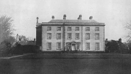
A front view of a large, three-story stone manor house with multiple chimneys and a symmetrical facade, set against a plain background.
A black and white photograph of the historic Castle Archdale manor house.

Castle Archdale Country Park history and protected-area timeline

The history of Castle Archdale begins in 1614, when the Archdale family arrived in Ulster as part of the Plantation of Ulster, the organized settlement of English and Scottish families in Ireland during the early seventeenth century. John Archdale, a Plantation undertaker from Norfolk, built the original castle the following year, in 1615. The castle was constructed on a T-plan and was protected by a defensive bawn roughly sixty-six feet by sixty-four feet and around fifteen feet high, with flankers at each corner. His son Edward later inherited and continued the estate.

The castle was destroyed twice in the seventeenth century: first in 1641, during the Irish Rebellion of 1641, when it was attacked by Rory Maguire, and then again in 1689, during the Williamite War in Ireland. After these turbulent decades, the estate eventually stabilized, and in 1773 a new mansion was constructed roughly a mile southwest of the original castle ruins. This mansion became the principal residence of the Archdale estate in its later centuries.

The estate then entered its most dramatic historical chapter during the Second World War. The mansion and surrounding grounds were requisitioned as the wartime headquarters for RAF Castle Archdale, which became a major base for flying boats. The base supported as many as 2,500 personnel and housed aircraft such as PBY Catalinas and Short Sunderlands tasked with protecting Atlantic shipping from German U-boat attacks. Ireland's neutrality in the war was quietly navigated through a secret agreement involving a narrow corridor of Irish airspace known as the Donegal Corridor, which allowed Castle Archdale aircraft to fly directly toward the Atlantic without a long detour north. In May 1941, two Catalinas from Castle Archdale were instrumental in locating the damaged German battleship Bismarck in the Atlantic, helping to set up its eventual sinking at the hands of Royal Navy torpedo bombers.

After the war, the mansion fell out of use and was eventually demolished in 1970. The cobbled courtyard and outbuildings survived, and today they house the park's information centre and tearooms. The former wartime layout still shapes the park, with the modern caravan site occupying the concrete maintenance area where aircraft were once serviced. A museum within the park preserves and interprets the wartime history, ensuring that the significance of RAF Castle Archdale remains visible within the present-day country park landscape.

Castle Archdale Country Park landscape and geographic character

Castle Archdale's landscape is shaped by its direct relationship with Lower Lough Erne, one of the two large lakes that together form the Lough Erne system in County Fermanagh. The park occupies a shoreline position, and water views and waterside terrain are central to its character. The lake offers a calm, often sheltered environment, with a finely broken shoreline typical of inland lake districts, where small bays, inlets, and reed-fringed edges create a varied scenic experience.

Inland from the shore, the park transitions into mixed woodland and open parkland. These wooded sections provide shaded walking routes and a sense of enclosure, while the more open spaces open up broad vistas across the lough. The park's planting, including ornamental and amenity trees established during its estate era, contributes to the parkland character that distinguishes Castle Archdale from wilder, unmanaged countryside.

The wider landscape around Castle Archdale is dominated by the Fermanagh lakelands. Lower Lough Erne is studded with islands, several of which, such as White Island, carry additional heritage significance. The neighbouring shoreline, including areas around Lisnarick and Irvinestown, is defined by gently rolling farmland interwoven with further stretches of water, giving the park a strongly lake-dominated setting rather than a mountain or coastal one. The result is a landscape defined primarily by water, woodland, and parkland rather than dramatic relief or rugged terrain.

Castle Archdale Country Park ecosystems, habitats, and plant life

The natural environment of Castle Archdale is anchored in its lake-edge and woodland ecosystems, typical of the Fermanagh lakeland zone. The shoreline of Lower Lough Erne creates a transitional habitat where freshwater, wet vegetation, and dry land meet, supporting rich birdlife and a wide range of plant communities rooted in the lakeside conditions. The wooded areas within the park, many of them planted or managed over centuries, add an additional ecological layer and contribute to habitat diversity.

As part of a broader lake district, the park sits within a landscape known for wetland habitats, mixed broadleaf woodland, and seasonal waterfowl activity. The shaded paths and varied tree cover create favourable conditions for woodland birds and small mammal populations, while the open shoreline is suited to species more commonly associated with freshwater habitats. Woodland, meadow, and wetland edges combine to give the park a layered ecological identity rather than a single dominant habitat type.

Castle Archdale Country Park wildlife and species highlights

Wildlife at Castle Archdale reflects the meeting of woodland and freshwater environments that defines the park. The wooded sections support typical songbird communities found in mature broadleaf stands, while the shoreline and open water of Lower Lough Erne attract waterfowl and other birdlife associated with large Irish lake systems. These overlapping habitats give visitors the chance to observe both woodland and water-associated species within a relatively compact area.

The lough itself is the most significant wildlife feature in the wider area, and Castle Archdale provides convenient access to that freshwater ecosystem. Reedy fringes, small inlets, and sheltered bays nearby offer habitat for nesting and feeding birds, particularly during seasonal movements when waterfowl activity increases. The park's role as a lakeside access point means it is commonly used as a starting point for broader wildlife observation across the Fermanagh lakelands.

Castle Archdale Country Park conservation status and protection priorities

As a publicly owned country park managed by the Northern Ireland Environment Agency, Castle Archdale has formal status as a protected and managed outdoor space. Its conservation value lies not only in its current use as a recreation site but also in the habitats it preserves along the Lower Lough Erne shoreline, including woodland, parkland, and waterside transitions. The presence of mature and semi-mature trees, as well as continuity of land use going back to the Plantation era, gives the park additional historic landscape significance alongside its ecological role.

The wider conservation context is shaped by Lough Erne itself, which is internationally recognized for its freshwater biodiversity and importance for waterfowl. Castle Archdale contributes to that broader conservation framework by managing a stretch of shoreline in a way that balances public access, habitat preservation, and heritage interpretation. The site's dual function as a recreation hub and a place of natural and historical importance gives it ongoing conservation relevance within the Northern Ireland countryside estate.

Castle Archdale Country Park cultural meaning and human context

Castle Archdale sits within a cultural landscape shaped by centuries of layered history. Its origins as a Plantation-era estate mark it as a tangible expression of the early seventeenth-century settlement of Ulster by English and Scottish families, while its later role as an RAF base during the Second World War adds a modern layer to that story. The fact that Irish neutrality and the Donegal Corridor allowed British aircraft to operate directly from this inland shore gives the park an unusual place in both Irish and British wartime memory.

The presence of a ferry connection to White Island adds another cultural dimension. White Island is associated with early Christian heritage, and the accessibility it gains through Castle Archdale ties the park into a wider cultural geography of monastic and early medieval sites scattered across the Fermanagh lakelands. Together, the Plantation ruins, the wartime museum, and the island ferry make Castle Archdale a meeting point of plantation history, wartime memory, and older Irish Christian heritage.

Top sights and standout views in Castle Archdale Country Park

Castle Archdale combines a wide range of attractions within a single lakeside setting. The shoreline of Lower Lough Erne provides scenic walking and water-based recreation, while woodland and parkland trails add variety to the on-site experience. A marina hosts a ferry to White Island, opening up further heritage exploration on the lake.

The park's strong identity comes from the pairing of peaceful natural scenery with intense historical resonance. Plantation-era castle ruins, a cobbled courtyard from a later demolished mansion, and a museum dedicated to RAF Castle Archdale all anchor the park in the broader stories of Ulster and the Second World War. The result is a destination where landscape, leisure, and layered history coexist in one compact setting.

Best time to visit Castle Archdale Country Park

Castle Archdale can be visited throughout the year, but its character shifts meaningfully with the seasons. In late spring and summer, the woodland is in full leaf, the lough is calm, and conditions are particularly favourable for walking, water sports, and outdoor recreation. Longer daylight and warmer weather also make the ferry to White Island and other lakeside activities more accessible.

In autumn, the park's mature trees become a focal point as foliage turns, and the still waters of Lough Erne often reflect seasonal colours at their most striking. Winter visits bring a quieter, more contemplative atmosphere, with reduced crowds and a different quality of light over the lake. Wildlife observation across the park and the wider lough tends to be especially rewarding during cooler months, when waterfowl activity increases around the Fermanagh lakes.
Monthly climate preview

Long term representative measurements tracking twelve month weather patterns

Castle Archdale Climate Normals, Annual Temperature and Precipitation Rhythm

Castle Archdale records tracked across twelve months show steady variations in average temperature and monthly precipitation at the monitored coordinate. Reviewing the complete climate profile provides deeper monthly averages for analyzing long term meteorological conditions.
Annual mean9 °C
4 °C14 °C
Jan
Feb
Mar
Apr
May10°
Jun13°
Jul14°
Aug14°
Sep12°
Oct
Nov
Dec
Warmest month
July

14.2 °C

Coolest month
January

4 °C

Wettest month
November

3.8 mm/day

Driest month
April

2.6 mm/day

Park location guide

Geography guide, regional context, and park location map for Castle Archdale Country Park

Castle Archdale Country Park park geography, regions, and map view in United Kingdom

Understand where Castle Archdale Country Park sits in United Kingdom through a broader geographic reading of the surrounding landscape, nearby location context, and its mapped position within the national park landscape.

How Castle Archdale Country Park fits into United Kingdom

The United Kingdom is a parliamentary constitutional monarchy located in northwestern Europe, consisting of four constituent countries: England, Scotland, Wales, and Northern Ireland. As a major global power with over 69 million residents, it maintains significant international influence in politics, economics, and culture.

Wider geography shaping Castle Archdale Country Park in United Kingdom

The United Kingdom is an island nation located in northwestern Europe, surrounded by the Atlantic Ocean, North Sea, English Channel, Celtic Sea, and Irish Sea. It shares a land border with the Republic of Ireland to the west. The territory includes the island of Great Britain, the northeastern portion of Ireland, and most of the smaller British Isles islands.

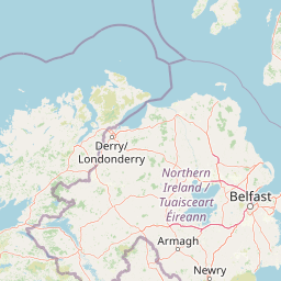
Map view of Castle Archdale Country Park

Use this park location map to pinpoint Castle Archdale Country Park in United Kingdom, understand its exact geographic position, and read its mapped placement within the surrounding landscape more clearly.

Pigeon | © OpenStreetMap contributors

Location context for Castle Archdale Country Park

County FermanaghNorthern Ireland

Examine the lakeside terrain, woodland canopy, and protected park environment through detailed imagery.

Castle Archdale Photos and Landscape Scenery Visual Exploration

Visual documentation reveals the diverse habitats, sheltered shoreline terrain, and woodland character defining Castle Archdale. Photographic records offer direct insight into the protected landscape surrounding Lower Lough Erne and its historic grounds.

A front view of a large, three-story stone manor house with multiple chimneys and a symmetrical facade, set against a plain background.

Park atlas

Compare nearby shorelines, regional woodlands, and connected protected areas

Parks Near Castle Archdale and Protected Landscapes in the Fermanagh Lakelands

Browsing nearby parks allows travelers to compare the distinct lake shorelines and woodland terrain surrounding Castle Archdale. Expanding the geographic view reveals how regional protected areas share similar waterways and natural habitats.
Nature reserveCounty Fermanagh
About 39 km away#1 closest

Southeast

Crom Estate Nature Reserve and Upper Lough Erne Geographic Landscape Overview

Riparian forest and island geography in County Fermanagh

Deeply connected to the shores of Upper Lough Erne, Crom Estate is a sprawling nature reserve defined by its ancient riparian woodlands and intricate maze of bays and islands. The terrain preserves a distinct mix of old-growth forest, open grassland, and historic castle ruins, providing a valuable case study in the regional geography of County Fermanagh and the conservation of water-influenced ecosystems.

Area
5.5 km²
Established
1987
Relief
Lowland
Climate
Temperate
Watercolor illustration of a mountainous landscape with a lake and forests
National parkCounty Donegal
About 53 km away#2 closest

North

Glenveagh National Park: A Protected Landscape in the Heart of County Donegal

Mapped geography and natural terrain for Ireland's national park.

Delve into the geographic specifics of Glenveagh National Park, a protected area situated in County Donegal. This section provides detailed information on its mapped boundaries and regional landscape context. Understand how this national park fits within the natural geography of Ulster, offering a structured atlas view for detailed exploration of its unique terrain and protected status.

Area
169.58 km²
Established
1986
IUCN
II
Relief
Mixed relief
Nature reserveNorthern Ireland
About 78 km away#3 closest

Northeast

Ballynahone Bog: Northern Ireland Lowland Raised Peatland and Wetland Geography

Intact active bog dome and protected wetland landscape

Examine the geography of Ballynahone Bog, one of the largest remaining lowland raised bogs in Northern Ireland. This protected landscape preserves an active peat-forming surface, intricate hummock and pool complexes, and marginal fen habitats, offering insight into the ecological history and hydrological patterns of the Lough Neagh lowland region.

Area
2.432 km²
Established
1995
Relief
Lowland
Climate
Temperate
Nature reserveCounty Londonderry
About 85 km away#4 closest

Northeast

Roe Estuary Nature Reserve: Coastal Geography and Protected Estuarine Landscapes

Lough Foyle coastal terrain in County Londonderry

Explore the structured geography of Roe Estuary Nature Reserve, a primary coastal protected area in County Londonderry. This atlas entry details the reserve's intertidal mudflats, salt marshes, and riverine channels. Understand its unique position between the Binevenagh escarpment and the waters of Lough Foyle, highlighting its role as a vital corridor for migratory species and aquatic life within the Northern Ireland coastal landscape.

Relief
Lowland
Climate
Temperate
Access
Access unknown
Scope
Mixed
Nature reserveNorthern Ireland
About 88 km away#5 closest

East

Oxford Island National Nature Reserve: Protected Wetland Landscapes of Northern Ireland

Lakeshore habitats and woodland geography at Lough Neagh

Oxford Island is a prominent nature reserve where terrestrial woodland meets the expansive waters of Lough Neagh. The site showcases a transition of reed beds and meadows that serve as vital ecological assets within the regional geography of Northern Ireland, offering a dense, accessible look at lowland wetland environments.

Area
1.14 km²
Relief
Lowland
Climate
Temperate
Access
Easy access
Nature reserveNorthern Ireland
About 89 km away#6 closest

Northeast

Lough Beg Nature Reserve: Mapping the Wetlands and Floodplains of Northern Ireland

An essential protected landscape within the Lough Neagh basin.

Lough Beg provides a distinct geographic study of freshwater ecosystems and alluvial landscapes. As a designated nature reserve, it forms a crucial link in the Lower Bann catchment, characterized by its shallow waters and seasonal pasture flooding. The area serves as a primary hub for migratory bird species, while the historic Church Island offers a unique convergence of early Christian heritage and natural wetland terrain.

Relief
Lowland
Climate
Temperate
Access
Easy access
Scope
Terrestrial
Watercolor illustration of a mountainous landscape with green fields in the foreground and distant mountains under a pale sky
National parkCounty Mayo
About 116 km away#7 closest

West

Wild Nephin National Park: Ireland's Protected Landscape in County Mayo

National Park with regional geographic context.

Explore Wild Nephin National Park, a significant protected area situated in County Mayo, Ireland. This entry focuses on the park's mapped boundaries and its unique natural terrain, offering a clear geographic perspective. Understand how this national park contributes to the diverse landscapes of western Ireland and serves as a key point for atlas-based discovery of protected lands.

Area
150 km²
Established
1998
IUCN
II
Climate
Temperate
Protected areaCounty Antrim
About 116 km away#8 closest

Northeast

Slieveanorra Forest Protected Area: Geography, Maps, and Upland Landscape Context

A comprehensive look at the Antrim forest and glacial landscape.

Slieveanorra Forest serves as a prominent protected area within the County Antrim uplands. Featuring expansive conifer woodlands, the site includes rugged terrain, reservoir edges, and scenic summit views. Understand the geological and environmental composition of this working forest landscape through its mapped boundaries and regional context.

Relief
Upland
Water
Minor water

Common questions about visiting, size, designation, and location context for Castle Archdale Country Park

Castle Archdale Country Park FAQs for park facts, access, geography, and protected area context

Find quick answers about Castle Archdale Country Park, including protected-area facts, park geography, trail and visitor context, and how the park fits into its surrounding country and regional landscape.
MoriAtlas Explorer

Continue Your Protected Areas Search Across the Global Atlas

Deepen your exploration by continuing the structured search for national parks and protected areas worldwide. Utilize the comprehensive filtering capabilities to compare different conservation landscapes and refine your understanding of global park geography. Discover more about the distribution and characteristics of protected natural areas.

Global natural geography