
Mori Atlas logo
National parkParque Nacional Aarón de Anchorena

Mapping the arboretum collections, riverbank habitats, and historic estate architecture

Parque Nacional Aarón de Anchorena: A Protected Riverine Landscape in Colonia Department

Located along the confluence of the Río San Juan and the Río de la Plata, Parque Nacional Aarón de Anchorena features a distinctive geography of ornamental woodlands and open grasslands. This protected area serves as a significant botanical site with over two hundred tree species and supports herds of free roaming axis deer. The landscape is marked by the historic presidential retreat and the prominent stone Torre Gaboto which overlooks the expansive estuary.

arboretumriverine landscapeestuaryintroduced wildlifeaxis deerhistoric estate
A colorful vector illustration showing a mountainous valley landscape with two waterfalls, pine trees in the foreground, and a sun in the sky.

Parque Nacional Aarón de Anchorena

National park

Park overview

Structured park overview, official facts, and landscape profile for Parque Nacional Aarón de Anchorena

Parque Nacional Aarón de Anchorena park facts, protected area profile, and essential visitor context

Review the core facts for Parque Nacional Aarón de Anchorena, including designation, size, terrain, visitor scale, habitats, and operating context in one park-focused overview.

About Parque Nacional Aarón de Anchorena

Parque Nacional Aarón de Anchorena occupies a privileged position at the meeting of two rivers, the San Juan and the broad Río de la Plata, in a region historically tied to the earliest European voyages along the South American coast. Its 1,369 hectares were part of a much larger estancia acquired early in the twentieth century by Aarón de Anchorena, an Argentine aristocrat of refined tastes and wide travels who saw in this land a canvas for his passions for botany, landscape design, and exotic wildlife.

Anchorena transformed the property into a richly planted estate, introducing trees, shrubs, and animals from across the world and commissioning the German landscape designer Hermann Botrich to lay out the grounds. The result is a landscape that mixes cultivated ornamental plantings, large open areas of lawn, groves of non-native trees, and natural riverbank vegetation, all framed by the wide estuary of the Río de la Plata.

When Anchorena died in 1965, his will left a portion of the estate to the Uruguayan state, with conditions that it be conserved, opened for public enjoyment and education, used as a place of rest for the president, and remain accessible from the river for visiting friends and dignitaries. The state formally accepted the bequest in 1968, and the park has since operated as one of Uruguay's most distinctive protected sites, combining its roles as a natural area, historic estate, arboretum, and ceremonial retreat.

The park's identity is unusually layered. Beyond its ecological and scenic qualities, it carries strong historical weight through its connection to the early Spanish exploration of the Río de la Plata, including the legendary site of the San Lázaro fortín established by Sebastián Gaboto in 1527 and the later San Juan fort founded in 1552. These layers of natural, personal, colonial, and political history give the park an unusually rich cultural texture.

Quick facts and research context for Parque Nacional Aarón de Anchorena

Parque Nacional Aarón de Anchorena lies in the department of Colonia, about 208 kilometers from Montevideo, and covers roughly 1,369 hectares donated by Aarón de Anchorena to the Uruguayan state. The park is also a designated National Historic Monument, reflecting its significance as both a natural and cultural site.

The territory sits on the left bank of the Río San Juan at its meeting with the Río de la Plata, giving the park extensive river and estuary frontage. Anchorena shaped the grounds by importing more than two hundred tree and shrub species from many continents, creating an arboretum of regional importance, and by introducing animals from abroad, most notably the Indian axis deer, which now thrives in the area as a signature presence.

Protection and recognition

Examining the established protection timeline and international recognition records for this conservation area

Parque Nacional Aarón de Anchorena Protection Status and Designation History

Documented protection records outline the official designation history and established conservation framework for Parque Nacional Aarón de Anchorena since 1968. Structured records compile available management context and international recognition details for comprehensive geographical analysis.

Protection details

Designated year
1968
Transboundary protection
No
Park context

Deeper park guide and search-rich context for Parque Nacional Aarón de Anchorena

Parque Nacional Aarón de Anchorena history, landscape, wildlife, and travel context

Explore Parque Nacional Aarón de Anchorena through its history, landscape character, ecosystems, wildlife, conservation priorities, cultural context, and seasonal travel timing in a structured park guide built for atlas discovery and search intent.

Why Parque Nacional Aarón de Anchorena stands out

The park is especially known for its arboretum collections and for its free-roaming herds of axis deer, both descended from species introduced by Aarón de Anchorena at the beginning of the twentieth century. These two features, the extraordinary botanical range and the visible exotic wildlife, give the park a character that blends ornamental landscape, woodland, and open plains. It is also known for housing the president's country residence and the tall Torre Gaboto, an unusual stone tower-lighthouse that dominates the park's skyline and frames views across the Río de la Plata toward Buenos Aires and the Argentine coast. This combination of natural setting, horticultural heritage, and historic architecture makes the park stand out among Uruguay's protected areas.
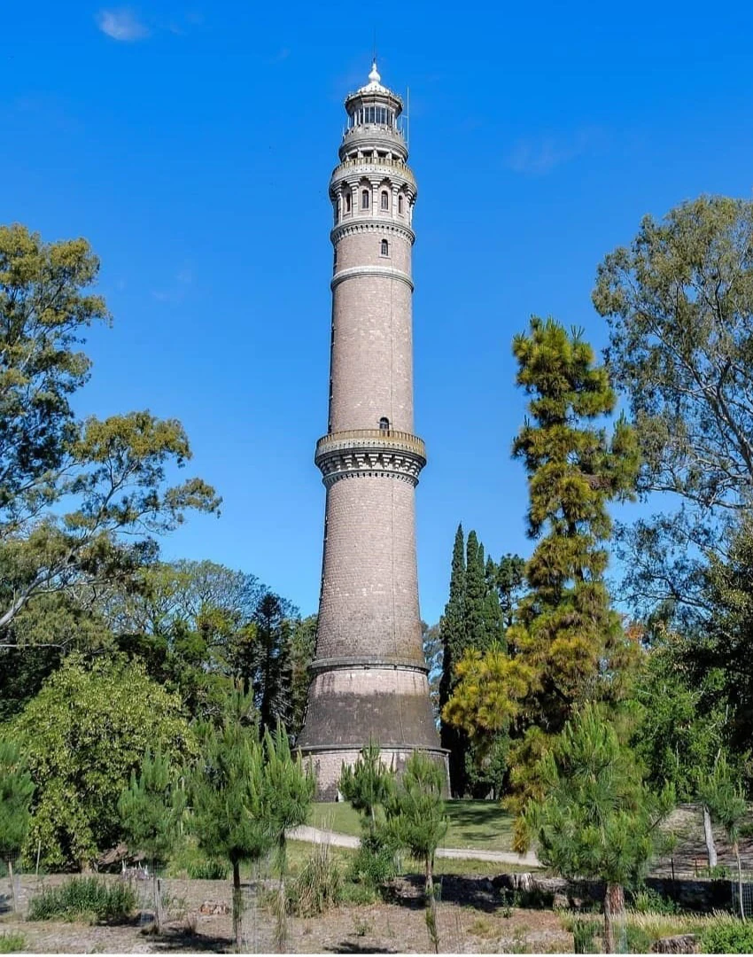
A tall, historic brick tower, Torre Gaboto, stands centered amidst lush green trees under a clear blue sky.
The historic Gaboto Tower rising above the forest canopy in Parque Nacional Aarón de Anchorena.

Parque Nacional Aarón de Anchorena history and protected-area timeline

The territory where the park now stands has a long human history. In 1527, on orders from the Venetian explorer Sebastián Gaboto, a small Spanish fortín named San Lázaro was erected in this region of the Río de la Plata, marking one of the earliest European outposts in the area. Although the fort was abandoned within a few years, the episode connects the landscape to the first chapter of European presence in the Río de la Plata. In 1552, a second fort, the fuerte de San Juan, was founded nearby by Juan Romero under Domingo Martínez de Irala, but it too was abandoned after repeated Charrúa attacks.

The modern history of the park begins with Aarón de Anchorena, whose vision shaped the land. In 1907, while crossing the Río de la Plata by balloon alongside his friend Jorge Newbery, Anchorena became fascinated by the north of the department of Colonia. His mother purchased around 11,000 hectares at the mouth of the Río San Juan, and over the following years Anchorena transformed the property into a grand estancia. He traveled the world on his ship "El Pampa," importing more than two hundred tree and shrub species from many continents and introducing animals such as axis deer from India, wild boar, kangaroos, buffaloes, and pheasants. The German landscape designer Hermann Botrich was commissioned to plan the grounds, while the original country house, a chapel, a dovecote, a nursery, and the striking Torre Gaboto were built to Anchorena's taste.

By the late 1930s, Anchorena's debts threatened the estate, and his wife Zelmira Paz sold her famous Buenos Aires residence, the Palacio Paz, to lift the mortgage and preserve the property. After Anchorena's death on 24 February 1965, around 1,370 hectares surrounding the original house were left to the Uruguayan state, subject to detailed conditions on conservation, public access, presidential use, and river access. The state accepted the bequest in 1968, and the park was opened to organized public visits in November 1990. Since then, the historic Anchorena house has functioned as Uruguay's presidential country retreat, hosting dignitaries from around the world while also serving as a site for guided interpretation of the park's natural and cultural values.

Parque Nacional Aarón de Anchorena landscape and geographic character

The park stretches along the left bank of the Río San Juan where it empties into the broad estuary of the Río de la Plata, giving the territory extensive river and shoreline frontage. This setting combines wide, flat country with the soft, reflective horizons typical of the Plata basin, where the waters open into one of the widest estuaries in the world and views reach across to the Argentine coast.

Within the park, the landscape shifts between open grassy areas, ornamental lawns, groves of exotic trees, native riverbank vegetation, and access points to the rivers. The original Anchorena house sits among planted gardens, while the surrounding estate preserves traces of the early designs of Hermann Botrich. The highest visible landmark in the park is the Torre Gaboto, a tall stone tower-lighthouse that rises above the tree line and serves as both a visual anchor for the park and a lookout over the Río de la Plata and, on clear days, the city of Buenos Aires.

The proximity of two rivers gives the park varied micro-settings, from sheltered inland gardens to breezy coastal stretches along the Plata. Combined with the planted woodlands and the open plains where herds of introduced animals graze, this produces a landscape that feels both cultivated and expansive.
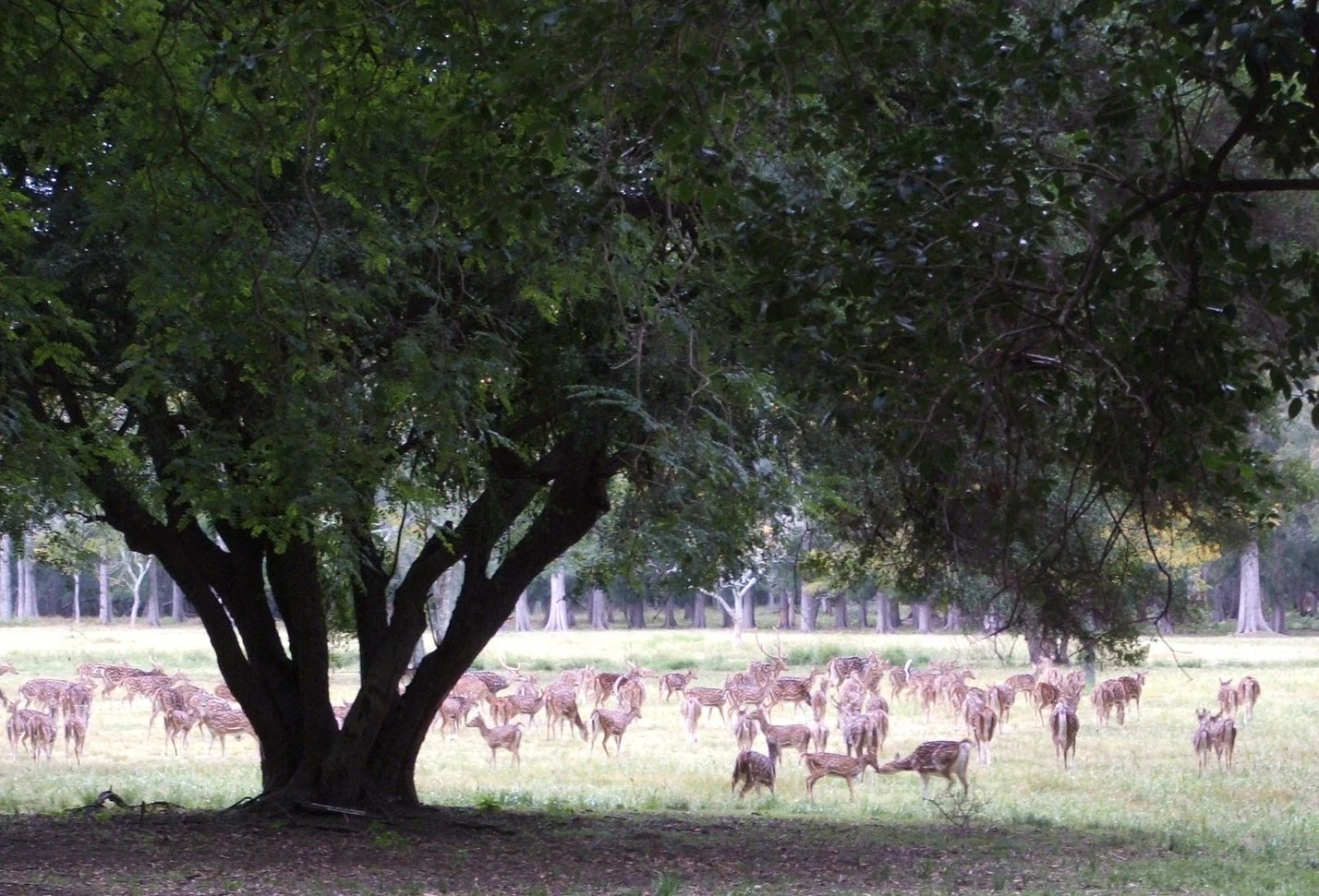
A large herd of spotted axis deer grazing in an open grassy area beneath the canopy of a large, mature tree.
A herd of axis deer grazing in the shade of a large tree at Parque Nacional Aarón de Anchorena.

Parque Nacional Aarón de Anchorena ecosystems, habitats, and plant life

Ecologically, the park is unusual in Uruguay because so much of its vegetation was deliberately assembled rather than naturally formed. The Anchorena estate functions as the country's second important arboretum, after the Arboretum Lussich, with broad collections of trees and shrubs from temperate, subtropical, and even distant regions. Notable plantings include white poplar, cork oak, araucarias, maples, bald cypress, more than fifty varieties of eucalyptus, liquidambar, native willows such as the sauce criollo, and the South American tipa.

Alongside these introduced species, the park preserves native riverbank vegetation and local woodland typical of the Río de la Plata region. The blend of exotic and native plants, set against a backdrop of open plains and estuary waters, gives the park a strongly hybrid ecological character that is rare in Uruguay's protected areas.

The rivers that border the park enrich this ecological profile. The Río San Juan and the Río de la Plata bring riparian habitats, transitional waters, and the influence of one of South America's largest estuarine systems into the protected area's natural setting.

Parque Nacional Aarón de Anchorena wildlife and species highlights

The park's most recognizable wildlife presence is its herd of axis deer, originally introduced from India by Aarón de Anchorena. These elegant spotted deer adapted readily to the Uruguayan countryside and are now a familiar sight in the park, moving in visible groups across the lawns and open areas. They have also spread beyond the park into surrounding regions.

Other animals introduced by Anchorena have had very different fates. Wild boar, possibly brought in for hunting, escaped and spread across Uruguay, becoming a national pest. Kangaroos, buffaloes, and pheasants, once kept on the estate, no longer survive in the country. Together, these stories of introduction and spread make the park a striking example of how introduced species can transform a landscape, both visually and ecologically.

The river and estuary setting of the park also supports native birdlife and other local fauna typical of the Río de la Plata basin, contributing a regional ecological backdrop to the more famous introduced mammals.

Parque Nacional Aarón de Anchorena conservation status and protection priorities

The park is doubly recognized for conservation. As a parque nacional, it is part of Uruguay's national system of protected areas, and separately it has been declared a Monumento Histórico Nacional, acknowledging its importance as a cultural and natural heritage site.

Its conservation value lies in the combined protection of a remarkable arboretum, an unusual set of introduced but adapted species (most notably the axis deer), and the river and estuary environments of the Río San Juan and Río de la Plata. The bequest terms imposed by Aarón de Anchorena also gave the park an unusually long-term conservation mandate, requiring that the land be preserved for public enjoyment, ecological protection, and educational use, rather than being converted to other purposes.

The park therefore serves multiple conservation functions at once: protecting rare and diverse plant collections, maintaining a green corridor along the rivers, preserving historic structures, and offering a controlled setting where introduced species can be observed and studied in a managed landscape.

Parque Nacional Aarón de Anchorena cultural meaning and human context

The park carries a layered cultural identity. Its earliest historical ties reach back to the first Spanish expeditions on the Río de la Plata, including the short-lived San Lázaro fortín erected under Sebastián Gaboto in 1527 and the later fuerte de San Juan founded in 1552, both of which connect the landscape to the opening chapter of European presence in the region.

In the twentieth century, the estate became a symbol of the cosmopolitan life of the Río de la Plata aristocracy. The original Anchorena house, built in 1911 in a blend of Norman and Tudor styles, reflects European architectural influences transplanted into the Uruguayan countryside. Its transfer to the state as a presidential country residence added another layer of identity, making the park a venue for diplomatic meetings and state ceremonies alongside its natural functions.

The Torre Gaboto, with its commemorative role honoring the early explorer Sebastián Gaboto, anchors the historical memory of the park, while preserved rural buildings, the chapel, the dovecote, and the nursery preserve the atmosphere of a traditional criollo estancia refreshed by Anchorena's worldwide travels.

Top sights and standout views in Parque Nacional Aarón de Anchorena

The Torre Gaboto, the long-established herds of axis deer grazing the open grounds, and the extensive arboretum of more than two hundred introduced tree species together give the park a distinctive and memorable profile. Its dual character as Uruguay's second important arboretum and a working presidential retreat adds a rare combination of natural and political heritage.

The park's river setting, where the Río San Juan meets the broad Río de la Plata, adds further distinction. Wide estuary views, riverbank habitats, and the calm of large open spaces give visitors a clear sense of the South American river coast that is hard to find elsewhere in Uruguay's protected-area network.

Best time to visit Parque Nacional Aarón de Anchorena

The Río de la Plata region has a temperate climate with mild winters and warm summers, and the park can be rewarding across much of the year. Spring and early summer tend to highlight the arboretum plantings, when many introduced trees and shrubs are in active growth or bloom, while autumn brings softer light and changing foliage across the groves.

Wildlife observation, especially of axis deer and birdlife along the riverbanks, is generally easier in the cooler and drier months, when animals are more visible in open areas and insects are less active. Summer visits bring warmer conditions for touring the grounds but should be balanced with attention to heat and river breeze. The park's setting on the estuary means that weather over the Río de la Plata can shift views and atmosphere quickly throughout the year.
Monthly climate preview

Long term temperature ranges and monthly precipitation distributions across representative coordinates

Parque Nacional Aarón de Anchorena Climate Normals and Annual Weather Patterns

Representative coordinate measurements document the recorded monthly temperature progression and precipitation averages for Parque Nacional Aarón de Anchorena from 1991 to 2020. Reviewing the comprehensive twelve month climate profile provides complete statistical context for this protected natural area.
Annual mean18 °C
11 °C24 °C
Jan24°
Feb24°
Mar22°
Apr19°
May15°
Jun12°
Jul11°
Aug12°
Sep14°
Oct17°
Nov20°
Dec23°
Warmest month
January

24.4 °C

Coolest month
July

10.9 °C

Wettest month
February

4 mm/day

Driest month
June

2 mm/day

Park location guide

Geography guide, regional context, and park location map for Parque Nacional Aarón de Anchorena

Parque Nacional Aarón de Anchorena park geography, regions, and map view in Uruguay

Understand where Parque Nacional Aarón de Anchorena sits in Uruguay through a broader geographic reading of the surrounding landscape, nearby location context, and its mapped position within the national park landscape.

How Parque Nacional Aarón de Anchorena fits into Uruguay

Uruguay is a unitary presidential republic located in southeastern South America. It covers approximately 176,215 km² and has a population of nearly 3.5 million people. The capital and largest city is Montevideo, where roughly 2 million people live in the metropolitan area. Uruguay gained independence between 1825 and 1828 following territorial disputes involving Portugal, Spain, Brazil, and the United Provinces of the Río de la Plata.

Wider geography shaping Parque Nacional Aarón de Anchorena in Uruguay

Uruguay is situated in the southeastern part of South America, bordering Argentina to its west and southwest, Brazil to its north and northeast, the Río de la Plata estuary to the south, and the Atlantic Ocean to the southeast. The terrain consists primarily of rolling plains and low hills, with the highest point being Cerro Catedral at approximately 514 meters. The country has several rivers including the Uruguay River, Paraná River, and Negro River.

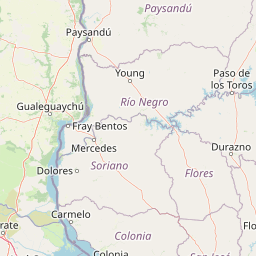
Map view of Parque Nacional Aarón de Anchorena

Use this park location map to pinpoint Parque Nacional Aarón de Anchorena in Uruguay, understand its exact geographic position, and read its mapped placement within the surrounding landscape more clearly.

Pigeon | © OpenStreetMap contributors

Location context for Parque Nacional Aarón de Anchorena

Colonia Department

Visual reference of arboretum collections, riverine habitats, and historic estuarine terrain.

Parque Nacional Aarón de Anchorena Photos and Protected Area Landscape Scenery

Visual documentation captures the diverse terrain, riverbank habitats, and planted woodlands that define the protected landscape of Parque Nacional Aarón de Anchorena. Examining detailed photography provides clear insight into the estuarine shoreline, arboretum collections, and open grounds characteristic of the region.

A tall, historic brick tower, Torre Gaboto, stands centered amidst lush green trees under a clear blue sky.

A large, multi-story Tudor-style residence with white stucco and timber frame details, situated in a wide, open grassy field surrounded by dense mature trees.

A large herd of spotted axis deer grazing in an open grassy area beneath the canopy of a large, mature tree.

Park atlas

Compare regional park geography, riverine terrain, and protected landscapes across Uruguay

Other Parks Near Parque Nacional Aarón de Anchorena and Surrounding Protected Areas

Browsing other parks near Parque Nacional Aarón de Anchorena reveals distinct regional geography and river basin terrain across southwestern Uruguay. Extending the protected area comparison helps map wider conservation landscapes, contrasting arboretum settings with neighboring reserves.
Natural monumentFlores
About 136 km away#1 closest

Northeast

Grutas del Palacio Natural Monument: Geological Landscape Map and Protected Area Context

Protected sandstone formations within the Flores region of central Uruguay

Grutas del Palacio represents a critical protected landscape in Flores, Uruguay, famous for its vaulted sandstone architecture and column-supported cavern structure. As an established natural monument, the site provides essential insights into Cretaceous sedimentary history and geoconservation. This record maps the natural features and territorial boundaries of this inland landmark, offering a structured look at its role in regional geography and geological heritage preservation.

Area
0.45 km²
Established
2013
Relief
Lowland
Climate
Subtropical
A soft, light-toned watercolor illustration of a river landscape with low green islands and marshy vegetation under a pale, minimalist sky.
National parkRío Negro Department
About 139 km away#2 closest

North

Parque nacional Esteros de Farrapos e Islas del Río Uruguay: Protected Wetland Geography

Exploring the fluvial island and riverine terrain of Río Negro

This protected area represents an essential riverine ecosystem along the western frontier of Uruguay. The landscape comprises a complex layering of flood-prone plains, riparian forest edges, and silty soil formations that characterize the regional geography of the Río Uruguay basin.

Area
215.65 km²
Established
2008
Relief
Lowland
Scope
Terrestrial
Protected landscapeFlores Department
About 153 km away#3 closest

Northeast

Localidad Rupestre de Chamangá: An Archaeological Protected Landscape in Flores Department

Explorations into the prehistoric rock art of rural Uruguay.

Located in central Uruguay, Localidad Rupestre de Chamangá protects a sprawling 12,000-hectare rural landscape notable for its dense cluster of rare open-air pictographs. The site offers profound insights into how prehistoric art interacts with granite topography and pastoral terrain, bridging cultural heritage and natural landscape conservation in the department of Flores.

Area
120 km²
Established
2010
Relief
Upland
Climate
Subtropical
Wildlife reserveRío Negro Department
About 154 km away#4 closest

North

Área de manejo de hábitats y/o especies Esteros y Algarrobales del Río Uruguay Protected Area Geography

Wildlife reserve in the Río Negro department with unique riparian corridors.

This wildlife reserve protects a unique transition zone where dry-forest Prosopis woodlands thrive alongside wetland esteros. Its mapped terrain reflects the intersection of two distinct ecoregions, creating a fragile landscape characterized by blanqueales soils, gallery forests, and river-fed floodplains within a larger protected conservation mosaic.

Area
15.5 km²
Relief
Lowland
Scope
Terrestrial
Water
Major water bodies
A watercolor painting of a wetland scene showing green, marshy areas and gentle, rolling hills in the background with soft brushwork.
Protected landscapeMontevideo
About 161 km away#5 closest

East

Humedales de Santa Lucía Protected Landscape: Geography and Mapped Wetland Boundaries in Uruguay

A dynamic tidal freshwater system located near the Montevideo riverfront

Humedales de Santa Lucía is a significant protected landscape spanning the departments of San José, Canelones, and Montevideo. This managed wetland ecosystem is defined by the interaction between freshwater river discharge and the brackish tidal influence of the Río de la Plata estuary, creating a unique riparian mosaic of channels, islands, and marshlands important to local waterbird populations.

Area
865.17 km²
Established
2015
Relief
Lowland
Access
Easy access
A watercolor painting showing stylized, rolling hills in shades of purple, green, yellow, and soft pink against a white background.
National parkCanelones Department
About 202 km away#6 closest

East

Isla de Flores National Park: Geographic Map and Protected Landscape Overview

Tidal island geography within the Río de la Plata estuary.

Located in the Canelones Department, Isla de Flores National Park represents a significant protected maritime area. Its landscape consists of a low-lying island reaching only two meters above sea level, featuring a protected maritime buffer that supports the integrity of this historic Río de la Plata site. Examine the mapped boundaries and the unique interplay between the estuary currents and this shifting coastal terrain.

Area
0.31 km²
Established
2018
Relief
Lowland
Climate
Temperate
A horizontal watercolor painting depicting a meandering river flowing through a green, hilly landscape with trees and soft, pastel lighting.
Protected areaPaysandú
About 241 km away#7 closest

North

Área protegida con recursos manejados Montes del Queguay: Geography and Protected Boundaries

Managed-resource landscape in the Paysandú river network

This protected area centers on a distinct floodplain basin in Paysandú, where silty soils and river confluence dynamics support a unique mosaic of riparian forest and wetland terrain. Explore the structural geography of this significant native woodland complex and its role within Uruguay's protected land system.

Area
434.1 km²
Established
1994
Relief
Lowland
Climate
Subtropical
National parkBuenos Aires Province
About 248 km away#8 closest

Southeast

Campos del Tuyú National Park: National Park Protected Area and Landscape Context

Mapped boundaries and regional geography for this Buenos Aires Province natural reserve.

Campos del Tuyú National Park represents a protected landscape within Argentina's Buenos Aires Province, offering a focused point for atlas-driven exploration. This entry details the park's designation as a national park, providing insights into its mapped geographic scope and its contribution to the regional natural landscape. Understand the foundational elements of this protected area for comparative geography and a structured understanding of conservation lands.

Area
30.4 km²
Established
2009
IUCN
II
Relief
Lowland

Common questions about visiting, size, designation, and location context for Parque Nacional Aarón de Anchorena

Parque Nacional Aarón de Anchorena FAQs for park facts, access, geography, and protected area context

Find quick answers about Parque Nacional Aarón de Anchorena, including protected-area facts, park geography, trail and visitor context, and how the park fits into its surrounding country and regional landscape.
MoriAtlas Explorer

Continue Your Protected Areas Search Across the Global Atlas

Deepen your exploration by continuing the structured search for national parks and protected areas worldwide. Utilize the comprehensive filtering capabilities to compare different conservation landscapes and refine your understanding of global park geography. Discover more about the distribution and characteristics of protected natural areas.

Global natural geography