Mori Atlas logo
National parkCampos del Tuyú National Park

Discover the mapped boundaries and regional context of this national park in Buenos Aires Province.

Campos del Tuyú National Park: Protected Landscape and Geographic Atlas Entry

(Parque Nacional Campos del Tuyú)

Campos del Tuyú National Park stands as a significant protected natural area within Argentina, specifically located in the Buenos Aires Province. This page serves as an atlas entry for understanding the park's protected landscape identity and its precise geographic setting. Delve into the mapped boundaries and the natural terrain that defines this important conservation area, providing essential context for geographic exploration and regional landscape study.

national parkArgentinaPampas grasslandcoastal wetlandpampas deerendangered species

Campos del Tuyú National Park

National park

Park overview

Structured park overview, official facts, and landscape profile for Campos del Tuyú National Park

Campos del Tuyú National Park park facts, protected area profile, and essential visitor context

Review the core facts for Campos del Tuyú National Park, including designation, size, terrain, visitor scale, habitats, and operating context in one park-focused overview.

About Campos del Tuyú National Park

Campos del Tuyú National Park was established on May 13, 2009, making it one of the newer additions to Argentina's national park system. The park was created specifically to protect the remaining populations of pampas deer in their native habitat, addressing a critical conservation need for one of the most threatened large mammal species in South America. The Pampas region, once a vast grassland ecosystem stretching across central Argentina, has been extensively transformed by agriculture, leaving only fragmented remnants of the original landscape. Campos del Tuyú represents one of these precious remaining fragments, preserving not only the pampas deer but also the broader ecological community that depends on the native grassland and coastal wetland habitats. The park's location on Samborombón Bay places it at the intersection of terrestrial and marine ecosystems, adding coastal and estuarine environments to the protected landscape. This ecological diversity, combined with the presence of multiple threatened species, makes Campos del Tuyú an important model for conservation in heavily modified agricultural landscapes.

Quick facts and research context for Campos del Tuyú National Park

Campos del Tuyú National Park is located in the southern part of Buenos Aires Province, Argentina, on the shores of Samborombón Bay. The park was established in 2009 and covers 3,040 hectares of pampas grassland and coastal wetland habitat. It is recognized as one of the last refuges for the pampas deer, a species that has been pushed to the brink of extinction across most of its former range in the Argentine Pampas. The protected area also supports populations of Geoffroy's cat, capybara, and more than one hundred bird species.

Protection and recognition

Tracking official terrestrial frameworks and conservation management records

Campos del Tuyú National Park Protection Status and Terrestrial Designation

Geographic datasets establish the terrestrial protection status and administrative boundaries of Campos del Tuyú National Park. Analyzing official designation records helps researchers and geographers map the spatial parameters of protected Argentine ecosystems.

Protection details

Protection scope
Terrestrial
Transboundary protection
No
Park context

Deeper park guide and search-rich context for Campos del Tuyú National Park

Campos del Tuyú National Park history, landscape, wildlife, and travel context

Explore Campos del Tuyú National Park through its history, landscape character, ecosystems, wildlife, conservation priorities, cultural context, and seasonal travel timing in a structured park guide built for atlas discovery and search intent.

Why Campos del Tuyú National Park stands out

Campos del Tuyú is best known as a refuge for the pampas deer, one of the rarest large mammals in South America. The park represents one of the few places where this endangered species survives in viable populations, making it a critical conservation site for pampas deer protection. Beyond this flagship species, the park protects a remnant tract of the once-vast Pampas grassland that has been largely converted to agriculture across its historic range. The combination of coastal marshland, native grassland, and the presence of multiple threatened species gives this relatively small park outsized ecological significance for the Pampas region.

Campos del Tuyú National Park history and protected-area timeline

Campos del Tuyú National Park was established in 2009 through the Argentine national park system, representing a relatively recent addition to the country's protected area network. The creation of the park responded to the urgent need to protect remaining populations of pampas deer, which had suffered catastrophic population declines throughout the 20th century as their grassland habitat was converted to agriculture. The park was designated as an IUCN Category II protected area, reflecting its national park status and primary focus on ecosystem conservation and species protection. Prior to formal protection, the area served as an informal refuge for wildlife, but formal establishment provided the legal framework and management resources necessary for effective long-term conservation. The relatively recent establishment of the park means that it represents a contemporary conservation response to the ongoing challenges facing the Pampas ecosystem.

Campos del Tuyú National Park landscape and geographic character

The landscape of Campos del Tuyú is characterized by the flat to gently rolling terrain typical of the Pampas grassland, interspersed with coastal marshland and wetland areas along Samborombón Bay. The native grassland of the Pampas once covered vast expanses of central Argentina, and while much of this habitat has been transformed by agriculture, the park preserves a more intact example of this ecosystem. The proximity to Samborombón Bay creates a diverse landscape that includes both inland grassland and coastal wetland environments, providing a transition zone between the terrestrial pampas and the estuarine waters of the bay. This topographic and ecological diversity gives the park a varied character despite its relatively small size, with different habitats supporting different assemblages of plant and animal species.

Campos del Tuyú National Park ecosystems, habitats, and plant life

The ecological character of Campos del Tuyú is defined by the Pampas grassland ecosystem, one of South America's most modified and threatened biomes. The native grasslands within the park represent some of the best-preserved examples of this habitat type remaining in the Pampas region. The coastal position also brings wetland and estuarine environments into the park's ecological portfolio, adding to the diversity of habitats protected. These grassland and wetland habitats together support a rich community of species, including several that are threatened or endangered. The park's role in preserving native grassland in a region that has been heavily transformed by agriculture gives it particular ecological significance beyond its size, as it protects functional ecosystems that have been largely lost from the surrounding landscape.

Campos del Tuyú National Park wildlife and species highlights

The wildlife of Campos del Tuyú is highlighted by the presence of the pampas deer, a species that has been driven to the edge of extinction across most of its historic range. The park is one of the few remaining places where this species survives, making it critically important for pampas deer conservation. Beyond the pampas deer, the park supports populations of Geoffroy's cat, a small wild cat species native to the South American grasslands, as well as capybara, the world's largest rodent, which thrives in the wetland and grassland habitats. The bird diversity of the park is particularly notable, with over one hundred bird species recorded within the protected area. This assembly of wildlife, combining rare large mammals, small predators, and diverse birdlife, represents a relatively intact ecological community for the Pampas region, where most native wildlife has been lost or drastically reduced.

Campos del Tuyú National Park conservation status and protection priorities

Campos del Tuyú serves as a critical conservation refuge for the pampas deer, a species that has suffered catastrophic population declines due to habitat loss, hunting, and competition with livestock across its historic range in the Argentine Pampas. The establishment of the park created formal protection for one of the last viable populations of this endangered species, providing a protected environment where pampas deer can persist without the immediate pressures that have eliminated them from most of their former habitat. Beyond pampas deer conservation, the park protects a broader suite of species including Geoffroy's cat and over one hundred bird species, representing a conservation umbrella for multiple components of the Pampas ecosystem. The protection of native grassland habitat within an otherwise heavily agricultural landscape also provides broader ecological benefits, including watershed protection, soil conservation, and the preservation of ecosystem services that benefit the surrounding region.

Campos del Tuyú National Park cultural meaning and human context

The Pampas region has deep cultural significance in Argentine history, associated with the gaucho traditions and the iconic cowboy culture that emerged from the grassland landscape. While the source material does not provide specific cultural details about the Campos del Tuyú area, the park exists within this broader cultural context of the Argentine pampean grassland. The region has been central to Argentine rural life and identity, though the extensive agricultural transformation of the Pampas has dramatically changed the cultural landscape. The preservation of native grassland in Campos del Tuyú maintains a connection to this heritage even as the surrounding lands have been converted to agriculture.

Top sights and standout views in Campos del Tuyú National Park

The primary highlight of Campos del Tuyú is its role as a refuge for the endangered pampas deer, one of the rarest large mammals in South America and a species on the brink of extinction in the wild. The park protects one of the last remaining populations of this iconic species, making it a critical site for pampas deer conservation. Supporting this flagship species is a diverse community of wildlife including Geoffroy's cat, capybara, and more than one hundred bird species. The park's location on Samborombón Bay adds coastal and wetland habitats to the protected landscape, creating ecological diversity within a relatively compact protected area. The preservation of native Pampas grassland in an otherwise heavily agricultural landscape gives the park additional significance as a living remnant of an ecosystem that has been largely lost.

Best time to visit Campos del Tuyú National Park

The park can be visited throughout the year, with each season offering different experiences of the pampas landscape. The spring and summer months typically offer warmer conditions and active wildlife viewing, while autumn and winter provide a different character to the grassland environment. The coastal location means that weather conditions can vary with the seasons, and visitors should plan accordingly for the pampean climate. Given the park's focus on wildlife conservation, visitors interested in observing pampas deer and other species should consider how seasonal patterns might affect wildlife activity and visibility.

Monthly climate preview

Long-term temperature profiles and daily precipitation averages from a low-elevation coordinate.

Campos del Tuyú National Park Climate and Monthly Weather Patterns

Representative climate data from 1991 to 2020 show mean temperatures at Campos del Tuyú National Park reaching up to 22.3 degrees Celsius alongside moderate daily precipitation patterns. Opening the full climate-normal dataset reveals deeper variations in historical monthly minimums, maximums, and long-term trends.
Annual mean15 °C
8 °C22 °C
Jan22°
Feb22°
Mar20°
Apr16°
May13°
Jun10°
Jul
Aug10°
Sep11°
Oct14°
Nov18°
Dec21°
Warmest month
January

22.3 °C

Coolest month
July

8.5 °C

Wettest month
April

3.5 mm/day

Driest month
May

2.1 mm/day

Park location guide

Geography guide, regional context, and park location map for Campos del Tuyú National Park

Campos del Tuyú National Park park geography, regions, and map view in Argentina

Understand where Campos del Tuyú National Park sits in Argentina through a broader geographic reading of the surrounding landscape, nearby location context, and its mapped position within the national park landscape.

How Campos del Tuyú National Park fits into Argentina

Argentina is a federal republic located in the southern cone of South America, bordering Chile, Bolivia, Paraguay, Brazil, Uruguay, and the Atlantic Ocean. With an area of 2,780,085 km², it is the second-largest country in South America and the eighth-largest globally. The capital and largest city is Buenos Aires, and the official language is Spanish. The country claims sovereignty over the Falkland Islands, South Georgia and the South Sandwich Islands, and a portion of Antarctica.

Wider geography shaping Campos del Tuyú National Park in Argentina

Argentina occupies the southern portion of South America, sharing the Southern Cone region with Chile to the west. The country borders Bolivia and Paraguay to the north, Brazil to the northeast, Uruguay and the South Atlantic Ocean to the east, and the Drake Passage to the south. The Andes mountain range runs along the western border, while the Pampas plains dominate the central region. Argentina also claims territories in Antarctica.

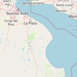
Map view of Campos del Tuyú National Park

Use this park location map to pinpoint Campos del Tuyú National Park in Argentina, understand its exact geographic position, and read its mapped placement within the surrounding landscape more clearly.

Pigeon | © OpenStreetMap contributors

Location context for Campos del Tuyú National Park

Buenos Aires Province
Park atlas

Compare Protected Landscapes and Trace Regional Conservation Efforts Across Argentina's Pampas

Discover More National Parks and Protected Areas Near Campos del Tuyú National Park

Discover other national parks and protected areas near Campos del Tuyú National Park, offering insight into adjacent conservation landscapes and diverse ecosystems. Compare these parks to understand the geographic spread of protected territories and broader conservation priorities across Argentina's varied environmental zones.
National parkCanelones Department
About 175 km away#1 closest

Northeast

Isla de Flores National Park: Geographic Map and Protected Landscape Overview

Tidal island geography within the Río de la Plata estuary.

Located in the Canelones Department, Isla de Flores National Park represents a significant protected maritime area. Its landscape consists of a low-lying island reaching only two meters above sea level, featuring a protected maritime buffer that supports the integrity of this historic Río de la Plata site. Examine the mapped boundaries and the unique interplay between the estuary currents and this shifting coastal terrain.

Area
0.31 km²
Established
2018
Relief
Lowland
Climate
Temperate
Protected landscapeMontevideo
About 180 km away#2 closest

North

Humedales de Santa Lucía Protected Landscape: Geography and Mapped Wetland Boundaries in Uruguay

A dynamic tidal freshwater system located near the Montevideo riverfront

Humedales de Santa Lucía is a significant protected landscape spanning the departments of San José, Canelones, and Montevideo. This managed wetland ecosystem is defined by the interaction between freshwater river discharge and the brackish tidal influence of the Río de la Plata estuary, creating a unique riparian mosaic of channels, islands, and marshlands important to local waterbird populations.

Area
865.17 km²
Established
2015
Relief
Lowland
Access
Easy access
National parkMaldonado
About 230 km away#3 closest

Northeast

Parque nacional Isla e islote de Lobos y su entorno sumergido: Protected Area Atlas

Mapping the oceanic terrain and rocky coastal landscapes of Uruguay

This resource provides a detailed geographic overview of Parque nacional Isla e islote de Lobos y su entorno sumergido. Explore the composition of this protected marine environment, which spans both rugged island terrain and extensive submerged rocky formations within the Atlantic waters of Maldonado.

Area
40 km²
Established
2024
Relief
Lowland
Climate
Temperate
National parkColonia Department
About 248 km away#4 closest

Northwest

Parque Nacional Aarón de Anchorena: Protected Geography and Riverine Landscape

An expansive arboretum and presidential estate in Colonia

Parque Nacional Aarón de Anchorena is a protected territory in southwestern Uruguay, defined by its position on the Río de la Plata estuary. The area encompasses an extensive arboretum, ornamental gardens, and riparian habitats that house unique animal populations. The site serves as a vital geographic anchor for the region, combining historic architecture with the broad, reflective horizons of the river coast.

Area
13.69 km²
Established
1908
Relief
Lowland
Climate
Temperate
Watercolor painting showing a hill with green landscape and distant mountains
National parkUruguay
About 268 km away#5 closest

Northeast

Arequita National Park: Uruguay's National Park Protected Landscape and Geography

Mapped boundaries and regional natural terrain context for a key protected area.

Delve into Arequita National Park, a designated national park contributing to Uruguay's protected land inventory. This resource explores the park's unique geographic setting, its mapped boundaries, and its significance within the natural landscape of the Southern Cone. Gain structured insight into its role as a protected area and its contribution to the regional geography of South America.

Scope
Terrestrial
Water
No major water
National parkLavalleja Department
About 268 km away#6 closest

Northeast

Parque nacional Arequita: Protected Landscape and Volcanic Geography in Lavalleja

Mapped natural terrain and protected ecosystems of southeastern Uruguay.

Parque nacional Arequita preserves a unique volcanic landscape in the Lavalleja Department, centered on the ancient basalt hill of Cerro Arequita. The area protects diverse environments ranging from rocky cave systems and native forests to critical freshwater watersheds. This record offers a deep look into the geographical character, internal boundaries, and ecological importance of one of Uruguay's most prominent natural sites.

Area
5.6 km²
Established
2024
Relief
Upland
Climate
Temperate
Wildlife reserveMaldonado
About 271 km away#7 closest

Northeast

Area de manejo de habitats y/o especies Laguna Garzon: Wildlife Reserve and Coastal Atlas

Mapped wetlands and Atlantic coastal landscapes in Maldonado, Uruguay.

The Area de manejo de habitats y/o especies Laguna Garzon protected area features a unique mosaic of interconnected lagoons and dune-backed shorelines. This coastal wildlife reserve offers a significant geographic study of wetland habitats and their interaction with the Atlantic maritime zone, providing essential context for understanding Uruguay's southeastern coastal terrain.

Established
2014
Water
Water-dominated
Protected landscapeRocha Department
291 km away#8 closest

Northeast

Laguna de Rocha Protected Landscape: Mapping Coastal Uruguay and its Dynamic Wetland Geography

Explore the unique barrier lagoon system and diverse coastal habitats of Rocha Department.

Laguna de Rocha functions as a vital coastal lagoon and wetland complex in southeastern Uruguay. Characterized by its shallow water and temporary sandbar breaches, the area supports a distinct mosaic of habitats, including dunes, reedbeds, and mudflats. Its status as a biosphere reserve and Important Bird Area underscores the ecological importance of this regional geography in providing a sanctuary for migratory waterbirds along the Atlantic coast.

Area
220 km²
Established
2010
Relief
Lowland
Climate
Temperate

Common questions about visiting, size, designation, and location context for Campos del Tuyú National Park

Campos del Tuyú National Park FAQs for park facts, access, geography, and protected area context

Find quick answers about Campos del Tuyú National Park, including protected-area facts, park geography, trail and visitor context, and how the park fits into its surrounding country and regional landscape.
MoriAtlas Explorer

Continue Your Protected Areas Search Across the Global Atlas

Deepen your exploration by continuing the structured search for national parks and protected areas worldwide. Utilize the comprehensive filtering capabilities to compare different conservation landscapes and refine your understanding of global park geography. Discover more about the distribution and characteristics of protected natural areas.

Global natural geography