

Mori Atlas logo
National parkIberá National Park

Discover the mapped boundaries and regional context of Iberá National Park.

Iberá National Park: National Park Atlas and Protected Landscape Geography in Corrientes Province

(Parque Nacional Iberá)

Iberá National Park stands as a significant national park within Corrientes Province, Argentina, contributing to the region's protected landscapes. This entry provides an atlas-focused view of Iberá National Park, detailing its geographic scope and role as a mapped conservation area. Understand its position within the natural geography of the Mesopotamia region and explore its protected boundaries.

wetlandsrewildingRamsar sitebirdwatchingcaimancapybara

Iberá National Park

National park

Park overview

Structured park overview, official facts, and landscape profile for Iberá National Park

Iberá National Park park facts, protected area profile, and essential visitor context
Review the core facts for Iberá National Park, including designation, size, terrain, visitor scale, habitats, and operating context in one park-focused overview.

About Iberá National Park

Iberá National Park represents one of Argentina's most significant recent conservation achievements, established in December 2018 to protect a portion of the Iberá Wetlands, one of the world's largest freshwater wetland systems. Located in the heart of Corrientes Province in northeastern Argentina, the national park forms part of an integrated conservation complex that includes the adjoining Iberá Provincial Park and the broader Iberá Provincial Nature Reserve, together comprising the largest protected area in Argentina at over 13,000 square kilometers. The park's creation was the culmination of more than two decades of conservation effort, beginning with land acquisitions by the Conservation Land Trust Argentina in 1999 and culminating with the donation of these lands to the Argentine state in 2015. The national park encompasses approximately 195,000 hectares distributed across four non-contiguous nuclei: Cambyretá, Rincón del Socorro, San Nicolás, and Carambola, each representing different habitat types within the Iberá ecosystem that were not previously protected within the provincial park system. The park's establishment was mandated by provincial law that required the national government to create the protected area within four years of the land cession, a deadline that was met with the passage of National Law 27481 on December 5, 2018. Beyond its ecological significance, the park is intended to support sustainable eco-tourism that can provide economic benefits to local communities while building broader support for conservation in the region.

Quick facts and research context for Iberá National Park

Iberá National Park occupies approximately 195,000 hectares in Corrientes Province, Argentina, within the Iberá Wetlands ecosystem. The park was officially established in December 2018 following more than a decade of land acquisition by the Conservation Land Trust Argentina, founded by Douglas and Kristine Tompkins. The protected area comprises four distinct nuclei without spatial continuity, adjacent to the provincial park and contained within the larger provincial nature reserve created in 1982. The park protects more than 4,000 species of flora and fauna, including over 360 bird species, and serves as a stronghold for vulnerable species such as the marsh deer and strange-tailed tyrant. A significant rewilding program has reintroduced multiple extirpated species since 2007, with jaguars being the most recent addition beginning in 2022.

Park context

Deeper park guide and search-rich context for Iberá National Park

Iberá National Park history, landscape, wildlife, and travel context
Explore Iberá National Park through its history, landscape character, ecosystems, wildlife, conservation priorities, cultural context, and seasonal travel timing in a structured park guide built for atlas discovery and search intent.

Why Iberá National Park stands out

Iberá National Park is best known for its position as Argentina's flagship rewilding initiative and its protection of the vast Iberá Wetlands, a Ramsar-designated wetland of international importance. The park has become a model for large-scale ecological restoration in South America, with successful reintroduction programs for jaguars, giant anteaters, pampas deer, South American tapirs, and red-and-green macaws. The wetlands support exceptional biodiversity including large populations of capybara, yacare caiman, and broad-snouted caiman, alongside hundreds of bird species. The park's creation represents a landmark achievement in Argentine conservation, combining private foundation efforts with government partnership to protect one of South America's most significant wetland ecosystems.

Iberá National Park history and protected-area timeline

The creation of Iberá National Park represents the culmination of a decades-long conservation journey that began with growing recognition of the Iberá Wetlands' ecological importance. The provincial nature reserve was established in 1982, followed by the creation of Iberá Provincial Park in 1993 as the reserve's core protection zone. The pivotal transformation began in 1999 when the Conservation Land Trust, established by conservationists Douglas and Kristine Tompkins, began acquiring former cattle ranch properties adjacent to the existing protected areas. These lands contained critical habitats that were not represented within the provincial park system, including espinal forests, marshland, and woodland areas. Over the following years, the organization systematically purchased approximately 180,000 hectares of land across four distinct nuclei, systematically removing cattle, ceasing the practice of burning land for cattle fodder, and removing interior fences to allow wildlife movement. In 2015, the Conservation Land Trust donated these lands to the Argentine state with the condition that they be declared a national park within one year. The provincial legislature ceded jurisdiction over 180,000 hectares to the national government in 2016 through Law 6384, which mandated the creation of a national park of approximately 157,000 hectares and a national reserve of approximately 23,000 hectares. After a four-year implementation period, National Law 27481 was passed on December 5, 2018, formally establishing Iberá National Park. The park's creation represented the largest addition to Argentina's national park system in decades and demonstrated the potential for public-private conservation partnerships.

Iberá National Park landscape and geographic character

The Iberá National Park protects a representative portion of the Iberá Wetlands, an extensive freshwater wetland system characterized by a complex mosaic of marshes, lagoons, channels, forests, and grasslands. The landscape is dominated by vast reed beds and floating vegetation that create the characteristic flooded environment of the wetlands, interspersed with islands of forest and elevated grassland areas known as islets. The wetland system sits within a depression that collects water from numerous streams and rivers, creating an intricate hydrological network that varies dramatically with seasonal rainfall patterns. Beyond the wetland cores, the park includes transitional areas of espinal woodland characterized by thorny scrub and semi-deciduous forests, as well as grassland plains that have historically been used for cattle ranching. The four nuclei that comprise the national park span different habitat types, with the San Nicolás nucleus being the largest at approximately 111,000 hectares and containing significant forest coverage, while the Carambola and Cambyretá nuclei include important grassland and wetland habitats. The landscape reflects a dynamic system where fire, flooding, and drought have shaped vegetation patterns over millennia, creating an ecosystem that depends on natural disturbances for its ecological health.

Iberá National Park ecosystems, habitats, and plant life

The Iberá Wetlands support exceptional biodiversity, with the combined protected area home to more than 4,000 species of flora and fauna, including over 360 species of birds. The wetland ecosystem provides critical habitat for waterfowl, wading birds, and marsh-dependent species, with the Ramsar-designated portion covering 24,500 hectares recognized as a Wetland of International Importance since 2002. The region's vertebrate diversity is remarkable for Argentina, with 641 species recorded including 125 fish, 40 amphibians, 63 reptiles, 347 birds, and 66 mammals. The wetlands function as a vital water reservoir and filtration system, providing flood regulation, drought mitigation, and climate stabilization services across the broader region. Vegetation communities range from submerged aquatic plants and emergent reeds in the wetlands to semi-deciduous forests, espinal thorn woodland, and native grasslands on higher ground. The ecosystem supports populations of marsh deer, the largest deer species in South America, which is classified as vulnerable and finds an important stronghold in the Iberá wetlands. The landscape also provides crucial habitat for the strange-tailed tyrant, another vulnerable bird species that depends on the wetland grasslands for breeding.

Iberá National Park wildlife and species highlights

Iberá National Park supports remarkable wildlife populations, with the wetlands providing habitat for some of the largest concentrations of megafauna in southern South America. The park contains substantial populations of capybara, the world's largest rodent, which congregate in enormous numbers along waterways and marsh edges. Both yacare caiman and broad-snouted caiman are common throughout the wetland system, with the park supporting significant populations of these apex predators. The wetlands host over 360 bird species, making it one of the most important bird areas in Argentina, with diverse assemblages of waterfowl, raptors, tinamous, and parrots. The park serves as a critical stronghold for the vulnerable marsh deer and the strange-tailed tyrant, both of which are species of conservation concern that depend on the wetland habitats. The park has also become a showcase for large-scale wildlife reintroductions as part of the ambitious rewilding program initiated in 2007, which has successfully established populations of giant anteater, collared peccary, South American tapir, pampas deer, bare-faced curassow, red-and-green macaw, and red-legged seriema. The jaguar reintroduction program, begun with a captive breeding facility, reached a milestone in January 2022 with the first wild release of a male jaguar, bringing the total introduced to eight individuals. Additional reintroductions include the giant river otter and ocelot.

Iberá National Park conservation status and protection priorities

Iberá National Park represents a landmark achievement in Argentine conservation, forming the core of what is now the largest protected area in Argentina and one of the most significant wetland conservation initiatives in South America. The park's creation addressed a critical gap in the protected area network by incorporating habitat types not represented within the existing provincial park, particularly espinal woodland and forest habitats. The Ramsar designation in 2002 recognized the wetlands' international importance, while the national park status provides the highest level of legal protection under Argentine law. The rewilding program has positioned the park as a global model for restoring extirpated species and reconstructing damaged ecosystems, with particular focus on returning apex predators like the jaguar to restore ecological processes. The Conservation Land Trust's approach of acquiring degraded cattle ranches, removing livestock, ceasing anthropogenic fire regimes, and restoring natural processes has demonstrated a pathway for ecological recovery in modified landscapes. The 2022 wildfires that burned nearly 60 percent of the park highlighted both the vulnerability of the ecosystem to extreme drought conditions and the resilience of fire-adapted grassland communities, while also underscoring the ongoing challenges of managing fire in a landscape where climate change is increasing fire frequency and intensity.

Iberá National Park cultural meaning and human context

The Iberá wetlands have been shaped by human activity for centuries, with the landscape historically influenced by indigenous Guarani peoples and later by European settlement patterns that established the cattle ranching economy that dominated the region. The provincial nature reserve created in 1982 reflected growing recognition that the wetlands required formal protection, while the subsequent establishment of the provincial park in 1993 provided core conservation zones. The creation of the national park built upon this provincial framework, with the 2016 provincial law mandating the transfer of lands to the national government representing a new level of governmental cooperation in conservation. Local communities have been integral to the conservation narrative, with the park's future linked to sustainable development strategies that can provide economic alternatives to the historical cattle ranching economy. The Committee Iberá, established in 2016, coordinates the involvement of various government agencies in implementing the master plan for the region's sustainable development. The park's creation has also drawn attention to the broader Mesopotamian grasslands region, which has been identified by BirdLife International as a priority Bird Endemism Area requiring urgent conservation attention.

Top sights and standout views in Iberá National Park

Iberá National Park stands as a demonstration of large-scale conservation vision, combining wetland protection with ambitious rewilding to restore ecological processes across a vast landscape. The wetland system itself is one of the largest in the world, providing critical habitat for waterfowl, caiman, capybara, and the vulnerable marsh deer. The jaguar reintroduction program represents a landmark achievement in restoring apex predators to an ecosystem from which they had been eliminated, with the first wild release occurring in 2022. The park protects over 4,000 species and provides Ramsar-protected wetland habitat of international importance. The four-nucleus structure of the park allows protection of diverse habitats including wetlands, forests, and grasslands that together form a comprehensive conservation mosaic within the larger provincial reserve.

Best time to visit Iberá National Park

The Iberá wetlands can be visited throughout the year, with each season offering distinct experiences and viewing opportunities. The wet season from October to March brings higher water levels that create expansive flooded landscapes, making boat tours through the wetlands particularly rewarding for observing waterfowl, wading birds, and caiman sunning on floating vegetation. The dry season from April to September concentrates wildlife around remaining water sources, making animal sightings more predictable and providing excellent opportunities for birdwatching and mammal observation. The shoulder seasons of spring and autumn offer moderate temperatures and balanced conditions, though the park's subtropical climate means that visitors should be prepared for heat and humidity throughout the year. The rewilding program has created opportunities for wildlife observation experiences that emphasize the park's conservation significance, though visitors should note that the park remains a relatively new protected area with tourism infrastructure still developing.
Park location guide

Geography guide, regional context, and park location map for Iberá National Park

Iberá National Park park geography, regions, and map view in Argentina
Understand where Iberá National Park sits in Argentina through a broader geographic reading of the surrounding landscape, nearby location context, and its mapped position within the national park landscape.

How Iberá National Park fits into Argentina

Argentina is a federal republic located in the southern cone of South America, bordering Chile, Bolivia, Paraguay, Brazil, Uruguay, and the Atlantic Ocean. With an area of 2,780,085 km², it is the second-largest country in South America and the eighth-largest globally. The capital and largest city is Buenos Aires, and the official language is Spanish. The country claims sovereignty over the Falkland Islands, South Georgia and the South Sandwich Islands, and a portion of Antarctica.

Wider geography shaping Iberá National Park in Argentina

Argentina occupies the southern portion of South America, sharing the Southern Cone region with Chile to the west. The country borders Bolivia and Paraguay to the north, Brazil to the northeast, Uruguay and the South Atlantic Ocean to the east, and the Drake Passage to the south. The Andes mountain range runs along the western border, while the Pampas plains dominate the central region. Argentina also claims territories in Antarctica.

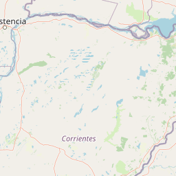
Map view of Iberá National Park

Use this park location map to pinpoint Iberá National Park in Argentina, understand its exact geographic position, and read its mapped placement within the surrounding landscape more clearly.

Pigeon | © OpenStreetMap contributors

Location context for Iberá National Park

Corrientes Province
Park atlas

Explore the regional geography, trace connected protected landscapes, and compare wetland conservation efforts.

Discover Other National Parks and Protected Areas Near Iberá National Park
Browse national parks and protected areas geographically close to Iberá National Park, encompassing wetland conservation complexes and adjacent terrestrial landscapes. Explore these related protected areas to understand the broader regional context of Argentine conservation efforts and compare diverse ecological systems.
National parkCorrientes Province

Mburucuyá National Park: National Park in Corrientes Province, Argentina

Iconic yatay palm savannas and diverse wetland ecosystems.

As a key national park within Argentina's Corrientes Province, Mburucuyá National Park offers a unique atlas-scale view of ecological convergence. It preserves expansive yatay palm savannas, critical wetland habitats within the Iberá Wetlands, and lush subtropical forests. The park's boundaries define an area where the Humid Chaco, Espinal, and Selva Paranaense biomes meet, creating a landscape of exceptional biodiversity and geographic significance for regional conservation and mapped exploration.

Area
176.82 km²
Established
2001
IUCN
II
Relief
Lowland
National parkItapúa Department

San Rafael National Park: National Park Protected Landscape & Geographic Overview

Discover the mapped boundaries and regional setting in Itapúa.

San Rafael National Park is a significant protected area designated as a national park in Paraguay's Itapúa Department. This page serves as an atlas-centric entry point, offering a detailed view of its geographic scope, mapped park boundaries, and its role as a conservation landscape. Users can explore the park's terrain and its place within the regional geography for a structured understanding of its protected status.

Area
693.04 km²
Established
1992
IUCN
II
Relief
Upland
National parkParaguay

Ypoá National Park: Paraguay's Protected Wetland Landscape and Lake Ecosystem

Explore mapped boundaries and significant bird habitats in the Ñeembucú region.

Ypoá National Park is a critical protected area in Paraguay, renowned for its extensive wetland ecosystems dominated by Lake Ypoá. This national park encompasses a rich mosaic of marshlands, riparian forests, and aquatic vegetation, making it a significant habitat for numerous bird species, including several rare and endemic types. Its designation as a Ramsar Wetland underscores its ecological importance, offering a unique lens for understanding landscape context and protected-area geography within South America.

Area
1,000 km²
Established
1992
IUCN
II
Relief
Lowland
National parkChaco Province

Chaco National Park: Protected Landscape and Regional Geography Atlas

Explore mapped boundaries within the Eastern Chaco's unique ecosystem.

Chaco National Park is an important protected area in Chaco Province, Argentina, dedicated to preserving the unique Eastern Chaco ecosystem. Covering 150 square kilometers, its landscape comprises warm lowland terrain with scrubland, savanna, swamp areas, and scattered lakes. This national park is recognized for its efforts to conserve the distinctive quebracho forests and supports a rich array of wildlife, making it a key site for understanding regional protected-area geography and landscape context.

Area
150 km²
Established
1954
IUCN
II
Relief
Lowland
National parkParaguay

Ñacunday National Park National Park: Paraguay's Protected Landscape and Mapped Boundaries

Explore its unique geography and protected terrain.

Gain a precise understanding of Ñacunday National Park, a designated national park in Paraguay. This entry focuses on its role as a protected landscape, detailing its geographic attributes and mapped boundaries. It serves as a vital resource for users seeking specific information on the park's natural terrain and its contribution to Paraguay's conservation geography, facilitating structured discovery within the atlas.

Area
20 km²
Established
1993
Relief
Mixed relief
Climate
Subtropical
National parkFormosa Province

Río Pilcomayo National Park: Protected Humid Chaco Wetland Landscape & Geography

Explore mapped boundaries and unique floodplain terrain in Formosa Province.

Río Pilcomayo National Park represents a significant protected natural area within Argentina's Formosa Province, characterized by the unique ecosystems of the Humid Chaco. The park's landscape is defined by extensive floodplains, marshes, lakes, and forests, all influenced by the Pilcomayo River's dynamic hydrological cycle. As a Ramsar site, it safeguards crucial habitats, including those for the endangered jaguar, and showcases iconic Caranday palm savannas. This detailed atlas entry provides insights into its mapped geography and the vital protected landscape it preserves.

Area
518.89 km²
Established
1951
IUCN
II
Relief
Lowland
National parkMisiones Province

Iguazú National Park: Argentina's Misiones Province Protected Landscape Atlas

Explore mapped boundaries and regional geography.

Iguazú National Park serves as a key protected natural area situated within Misiones Province. This MoriAtlas entry details its mapped geographic boundaries, contributing essential context for understanding its landscape identity. Users can explore how this national park fits into the regional geography, providing a factual basis for detailed atlas-based study of protected lands and their unique terrain.

Area
677 km²
Established
1934
IUCN
II
Relief
Lowland
National parkEntre Ríos Province

El Palmar National Park: Protected Area Atlas and Geographic Exploration in Entre Ríos

Discover mapped park boundaries and regional landscape context.

El Palmar National Park offers a dedicated space for understanding protected landscapes within Argentina. As a designated national park situated in Entre Ríos Province, it serves as a crucial point for exploring mapped natural terrain and regional geography. This entry provides specific details on its protected area status and its contribution to the broader atlas of conservation lands in the Mesopotamia region.

Area
85 km²
Established
1966
IUCN
II
Access
Easy access

Common questions about visiting, size, designation, and location context for Iberá National Park

Iberá National Park FAQs for park facts, access, geography, and protected area context
Find quick answers about Iberá National Park, including protected-area facts, park geography, trail and visitor context, and how the park fits into its surrounding country and regional landscape.
MoriAtlas Explorer

Continue Your Protected Areas Search Across the Global Atlas

Deepen your exploration by continuing the structured search for national parks and protected areas worldwide. Utilize the comprehensive filtering capabilities to compare different conservation landscapes and refine your understanding of global park geography. Discover more about the distribution and characteristics of protected natural areas.

Global natural geography

