Mori Atlas logo
Wildlife reserveÁrea de protección de flora y fauna Pico de Tancítaro

Examining the ecological boundaries and mountainous terrain of this federal wildlife reserve

Área de protección de flora y fauna Pico de Tancítaro: A Volcanic Protected Landscape in Michoacán

Located in the heart of the Trans-Mexican Volcanic Belt, Área de protección de flora y fauna Pico de Tancítaro encompasses the rugged volcanic massif of its namesake peak. This wildlife reserve serves as a vital ecological corridor, protecting expansive mixed pine and oak forests that sustain regional biodiversity and Purépecha cultural traditions. The landscape demonstrates the transition between ancient mountain slopes and recent volcanic features, providing essential insights into the complex geography of central Mexico.

pico de tancítaroflora and fauna protection areamichoacántrans-mexican volcanic beltpine-oak forestmixed conifer forest

Área de protección de flora y fauna Pico de Tancítaro

Wildlife reserve

Park overview

Structured park overview, official facts, and landscape profile for Pico de Tancítaro Flora and Fauna Protection Area

Pico de Tancítaro Flora and Fauna Protection Area park facts, protected area profile, and essential visitor context

Review the core facts for Pico de Tancítaro Flora and Fauna Protection Area, including designation, size, terrain, visitor scale, habitats, and operating context in one park-focused overview.

About Pico de Tancítaro Flora and Fauna Protection Area

The Pico de Tancítaro Flora and Fauna Protection Area is a federally recognized Mexican protected natural area situated in the state of Michoacán in west-central Mexico. It encompasses the rugged volcanic terrain surrounding the Pico de Tancítaro peak and extends across parts of four municipalities: Tancítaro, Uruapan, Nuevo Parangaricutiro, and Peribán. This highland region forms part of the Trans-Mexican Volcanic Belt, a major geological and ecological corridor that runs across central Mexico and supports a remarkable diversity of forest types.

From an ecological perspective, the reserve is dominated by extensive mixed pine and pine-oak forests. Several pine species characterize the canopy, including Pinus pseudostrobus, Pinus leiophylla, Pinus douglasiana, Pinus maximinoi, Pinus devoniana, Pinus hartwegii, and Pinus montezumae. These conifers form a structural mosaic with numerous oak species such as Quercus laurina, Quercus crassifolia, Quercus obtusata, and Quercus candicans, producing the classic montane pine-oak forest assemblages of central Mexico. The flora is further enriched by firs (Abies), madrones (Arbutus xalapensis), American hornbeams (Carpinus caroliniana), Mexican cedars (Cupressus lusitanica), native dahlias such as Dahlia scapigera, and Mexican linden (Tilia americana var. mexicana), underlining the botanical richness that the reserve is designed to safeguard.

The protected area is also home to a wide array of fauna. Mammals include the white-nosed coati, the Tancítaro endemic rodent Nelsonia goldmani, the Michoacán pocket gopher Zygogeomys trichopus, the red-bellied squirrel, the Virginia opossum, the white-sided jackrabbit, the nine-banded armadillo, and the southern flying squirrel. The avifauna includes raptors such as Cooper's hawk, and the reserve also supports notable amphibians and reptiles including the Mexican axolotl (Ambystoma amblycephalum), the Pátzcuaro peeping frog, the Montezuma frog, the black iguana (Ctenosaura pectinata), and pollinating bats such as the Curaçaoan long-nosed bat (Leptonycteris curasoae). The presence of multiple restricted-range and NOM-059-listed species underscores the reserve's role in conserving Mexico's highland biodiversity.

Beyond ecology, the area is deeply intertwined with the cultural and economic life of the local population. The four municipalities that fall partially within the reserve are among Michoacán's most important timber-producing regions, collectively contributing a significant share of the state's net timber output. Their inhabitants, many of whom belong to the Purépecha indigenous community, maintain communal property rights and continue to draw their livelihoods from agriculture and forest use. This relationship between people and landscape gives the reserve an identity rooted not only in conservation but also in sustainable land stewardship and regional cultural continuity. The proximity of the reserve to the Paricutín volcano further amplifies its appeal, offering a landscape where centuries-old pine communities meet the geological dynamics of one of Mexico's youngest volcanoes.

Quick facts and research context for Pico de Tancítaro Flora and Fauna Protection Area

The Pico de Tancítaro Flora and Fauna Protection Area is a federally designated natural reserve in Michoacán, Mexico, encompassing a territory that spans the municipalities of Tancítaro, Uruapan, Nuevo Parangaricutiro, and Peribán. It covers a total protected surface of roughly 23,400 hectares and is organized into a smaller core zone of about 2,790 hectares surrounded by an extensive buffer zone of around 20,700 hectares. The reserve lies about 29 kilometers west of the city of Uruapan and borders the iconic Paricutín volcano landscape, one of the youngest volcanic formations in the Americas.

The area is dominated by mixed pine and pine-oak forests typical of Mexico's highland volcanic terrain and supports a recorded biodiversity of more than 935 species of plants and animals. Of these, 41 fall within some category of risk under Mexico's NOM-059 ecological protection standard, and 22 are non-native species. The region's municipalities are collectively responsible for a substantial share of Michoacán's timber production, giving the protected area important ecological as well as economic relevance for the surrounding communities.

Protection and recognition

Review documented terrestrial protection scope and recognized management records

Área de protección de flora y fauna Pico de Tancítaro Protection Status

Terrestrial protection status for Área de protección de flora y fauna Pico de Tancítaro encompasses verified conservation boundaries and administrative records. Systematic database tracking details official protected area designations without speculative assumptions.

Protection details

Protection scope
Terrestrial
WDPA ID
6063020
Core area
27.9 km²
Park context

Deeper park guide and search-rich context for Pico de Tancítaro Flora and Fauna Protection Area

Pico de Tancítaro Flora and Fauna Protection Area history, landscape, wildlife, and travel context

Explore Pico de Tancítaro Flora and Fauna Protection Area through its history, landscape character, ecosystems, wildlife, conservation priorities, cultural context, and seasonal travel timing in a structured park guide built for atlas discovery and search intent.

Why Pico de Tancítaro Flora and Fauna Protection Area stands out

Pico de Tancítaro is known above all for its extensive mixed pine and pine-oak forests, which dominate the volcanic highlands of Michoacán and contribute significantly to the state's timber production. The reserve protects one of the most ecologically diverse highland forest blocks of the Trans-Mexican Volcanic Belt, harboring numerous native and endemic species of plants, mammals, birds, reptiles, and amphibians, many of which are listed under Mexican conservation risk categories. The area is also distinguished by its proximity to the Paricutín volcano, allowing visitors and researchers to observe a striking landscape where mature pine forests coexist with young volcanic terrain. The reserve's combination of ecological richness, productive forests, and close integration with Purépecha communal land traditions gives it a uniquely layered identity among Mexico's federal protected natural areas.
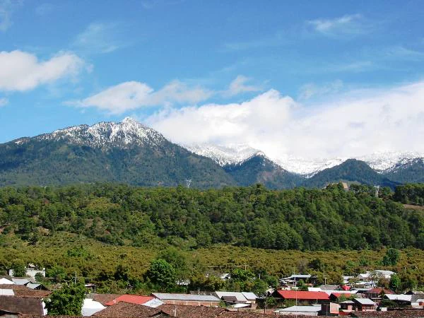
A wide shot showing a mountain range with snow-covered peaks, densely forested slopes, and a small town with red-tiled roofs in the foreground under a blue sky with light clouds.
The snow-capped Pico de Tancítaro mountain rising above the surrounding forests and local dwellings in Michoacán, Mexico.

Pico de Tancítaro Flora and Fauna Protection Area history and protected-area timeline

The protected area's origins lie in a presidential decree issued on July 27, 1940, by President Lázaro Cárdenas, which established the original Parque Nacional Pico de Tancítaro as a national park focused on the conservation of the highland forests and the surrounding volcanic landscape.

For decades, the area operated under this national park designation, but evolving Mexican conservation policy, along with the need to better integrate productive forestry and community land use, led to a reassessment of its protection category. On August 19, 2009, a new presidential decree published in the Diario Oficial de la Federación reclassified the territory as an Área de Protección de Flora y Fauna (APFF), or Flora and Fauna Protection Area. This new designation introduced a more flexible management framework, organizing the territory into a clearly delimited core zone of roughly 2,790 hectares, primarily within the municipality of Tancítaro, and a buffer zone of approximately 20,700 hectares that encompasses the surrounding landscape.

This change reflected an updated approach to conservation in Mexico, one that recognizes not only the ecological value of forest ecosystems but also the economic importance of the timber resources for the surrounding communities. Today, the reserve stands as part of the country's broader network of federal natural protected areas, administered under the framework of the National Commission of Natural Protected Areas (CONANP).

Pico de Tancítaro Flora and Fauna Protection Area landscape and geographic character

The landscape of the Pico de Tancítaro reserve is shaped by the volcanic geography of the Trans-Mexican Volcanic Belt. The dominant feature is the Pico de Tancítaro volcano itself, a stratovolcanic peak whose slopes and surrounding ridges form the core of the protected territory. Elevations across the area place it firmly within the montane and high-montane zones of central Mexico, with terrain that ranges from steep slopes and forested ridges to gentler highland valleys.

A particularly notable aspect of the regional landscape is its proximity to the Paricutín volcano just 29 kilometers west of Uruapan, one of the most famous young volcanoes in the world. The adjoining volcanic terrains produce a striking contrast between mature pine-oak forests on the older slopes of Tancítaro and the comparatively barren, recent lava fields surrounding Paricutín. This juxtaposition gives the broader region its distinctive geological character and underscores the continued volcanic activity that has shaped local ecosystems.

The reserve's topography is further defined by a network of forested ridges, deep drainages, and forested valleys that connect the Tancítaro massif with adjacent landscapes. These physiographic features create varied microhabitats and ecological transitions, which in turn support the diverse vegetation and wildlife communities found within the protected area.

Pico de Tancítaro Flora and Fauna Protection Area ecosystems, habitats, and plant life

Ecologically, the Pico de Tancítaro reserve belongs to the montane and high-montane forest biomes of central Mexico, with a strong dominance of mixed pine and pine-oak vegetation. The pine canopy is notable for its diversity, including species typical of both mesic mid-elevation forests and higher altitude coniferous assemblages. These pines integrate with a rich community of oaks, producing structurally complex forests that are highly productive in terms of timber while also providing essential habitat for a wide range of native species.

Alongside the dominant pine-oak matrix, the reserve features stands of fir, madrone, American hornbeam, Mexican cypress, Mexican linden, and native dahlias, contributing to a varied understory and mid-canopy. This botanical diversity supports healthy populations of pollinators, including the long-tongued Curaçaoan bat, which is among the key species documented in the area. The mosaic of forest types, altitudinal gradients, and microclimates within the reserve creates favorable conditions for species that depend on specific habitat conditions, including several endemic rodent taxa and amphibians tied to particular highland environments.

As a consequence, the protected area serves as a critical refuge within a wider landscape heavily impacted by forestry and agriculture. Its core zone provides strict protection for the most ecologically sensitive habitats, while the buffer zone accommodates compatible land uses that support the regional economy and local livelihoods.

Pico de Tancítaro Flora and Fauna Protection Area wildlife and species highlights

Wildlife within the Pico de Tancítaro reserve reflects the biological richness typical of Mexico's highland volcanic forests. The reserve is documented to harbor more than 935 species of plants and animals combined, of which 41 are considered to be under some level of conservation risk according to the NOM-059 ecological standard. The mammal community includes notable species such as the white-nosed coati, the endemic Tancítaro woodrat (Nelsonia goldmani), the Michoacán pocket gopher (Zygogeomys trichopus), the red-bellied squirrel, the Virginia opossum, the white-sided jackrabbit, the nine-banded armadillo, and the southern flying squirrel. These mammals together represent both widespread Neotropical species and locally restricted taxa of high conservation interest.

The birdlife of the reserve includes raptors such as Cooper's hawk, which occupies the forested slopes as a breeding and hunting species. Reptiles are represented by species such as the black iguana (Ctenosaura pectinata), which thrives in the warmer forest edges and rocky clearings of the protected area. Amphibians are another important component of the fauna, including the endemic Mexican axolotl (Ambystoma amblycephalum), the Pátzcuaro peeping frog (Eleutherodactylus angustidigitorum), and the Montezuma frog (Lithobates montezumae), all of which are associated with the sometimes humid microhabitats found within the broader pine-oak forest mosaic.

The presence of the Curaçaoan long-nosed bat (Leptonycteris curasoae), a key pollinator of several columnar cacti and other native plants, highlights the reserve's ecological role beyond simple species inventories. Together, these varied faunal groups illustrate the wildlife significance of a protected area that, despite its relatively modest extent, harbors a substantial portion of Michoacán's montane biodiversity.

Pico de Tancítaro Flora and Fauna Protection Area conservation status and protection priorities

The ecological importance of the Pico de Tancítaro Flora and Fauna Protection Area extends well beyond its boundaries. Its forests help regulate the hydrological systems of a large portion of western Michoacán, sustain essential habitat connectivity across the Trans-Mexican Volcanic Belt, and support species migration and dispersal between the Tancítaro massif and the neighboring Paricutín volcanic landscape. The reserve's consolidation as a flora and fauna protection area in 2009 marked an important shift in Mexican conservation strategy toward more flexible management models that integrate strict habitat protection with the sustainable economic use of surrounding landscapes.

Its core zone, primarily located within the municipality of Tancítaro, is intended to provide the highest level of habitat protection for the most ecologically sensitive areas, including key biodiversity hotspots and populations of NOM-059-protected species. The buffer zone, by contrast, allows for regulated forestry and other compatible productive activities, recognizing the importance of the timber economy for local communities. This dual structure aims to balance biodiversity preservation with the socio-economic needs of residents who depend on forest resources.

By protecting a substantial block of highland pine-oak forest, safeguarding rare and endemic species, and preserving the ecological connectivity of the regional volcanic landscape, the reserve contributes meaningfully to the broader conservation network of Mexico's central highlands.

Pico de Tancítaro Flora and Fauna Protection Area cultural meaning and human context

The territory protected by the Pico de Tancítaro reserve is closely linked to Purépecha communities whose presence and traditions have shaped the region for centuries. Many of the inhabitants of the nearby Paricutín area, as well as residents within the reserve's municipalities, identify as Purépecha and maintain strong cultural ties to the land. Communal land ownership, known as propiedad comunal, continues to play a central role in how local communities organize their relationship with the surrounding forests and agricultural fields.

These communities sustain themselves through a combination of subsistence agriculture, seasonal crops, and the careful exploitation of forest products, particularly timber. The four municipalities that share territory with the reserve collectively represent a significant share of Michoacán's timber-producing capacity, underscoring the deep economic dependence of the region on the forests that the reserve now helps to protect. Far from being purely a backdrop for conservation, the cultural identity, land tenure systems, and traditional ecological knowledge of the Purépecha people form an integral part of the protected area's broader significance.

Top sights and standout views in Pico de Tancítaro Flora and Fauna Protection Area

The Pico de Tancítaro reserve stands out as one of Michoacán's most ecologically significant federal protected areas, anchored by the volcanic massif of Pico de Tancítaro and surrounded by the iconic Paricutín volcanic landscape. Its mixed pine and pine-oak forests are recognized as among the most productive timber forests in the state, while simultaneously harboring exceptional biodiversity, including endemic rodents, restricted-range amphibians, and pollinating bats. The protected area's management model, with a clearly defined core zone and a broader buffer zone, reflects a modern approach that integrates biodiversity protection with the economic and cultural needs of the surrounding Purépecha communities. Together, these attributes make the reserve a benchmark example of integrated conservation in Mexico's volcanic highlands.

Best time to visit Pico de Tancítaro Flora and Fauna Protection Area

Seasonal conditions across the Michoacán highlands shape both the atmosphere and the ecological character of a visit to the Pico de Tancítaro reserve. The dry season, generally spanning the cooler months from late autumn through early spring, tends to offer clearer skies, more accessible forest trails, and stronger panoramic views of the surrounding volcanic terrain, including the Paricutín landscape. The wet season, which coincides with the warmer summer months, brings greener forest conditions, increased humidity, and more active wildlife behavior, including elevated amphibian activity and an increased presence of pollinating bats and insects. Travelers interested in observing the pine-oak canopy at its most lush or in maximizing chances of seeing amphibians and seasonal bird activity may favor the wetter months, while those seeking clearer vistas and generally drier hiking conditions may prefer the dry season. The region's highland microclimates mean that temperatures remain relatively mild year-round, with cooler conditions at higher elevations of the Tancítaro massif.

Monthly climate preview

Long term monthly temperature averages and precipitation patterns across the protected landscape

Annual Climate Normals and Temperature Rhythms for Área de protección de flora y fauna Pico de Tancítaro

Representative coordinate records show average monthly temperatures ranging from 18.16 °C to 25.28 °C alongside distinct seasonal precipitation shifts between dry months and heavier rainfall periods. Complete monthly climate normals reveal comprehensive multiyear temperature extremes and daily precipitation values for more detailed environmental analysis.
Annual mean21 °C
18 °C25 °C
Jan18°
Feb20°
Mar22°
Apr24°
May25°
Jun24°
Jul22°
Aug22°
Sep21°
Oct21°
Nov20°
Dec19°
Warmest month
May

25.3 °C

Coolest month
January

18.2 °C

Wettest month
July

5 mm/day

Driest month
April

0.1 mm/day

Park location guide

Geography guide, regional context, and park location map for Pico de Tancítaro Flora and Fauna Protection Area

Pico de Tancítaro Flora and Fauna Protection Area park geography, regions, and map view in Mexico

Understand where Pico de Tancítaro Flora and Fauna Protection Area sits in Mexico through a broader geographic reading of the surrounding landscape, nearby location context, and its mapped position within the national park landscape.

How Pico de Tancítaro Flora and Fauna Protection Area fits into Mexico

Mexico, officially the United Mexican States, is a country in North America spanning the Sierra Madre mountain ranges, coastal plains, and tropical regions. It borders the United States to the north, Guatemala and Belize to the southeast, and has coastlines along the Pacific Ocean, Gulf of Mexico, and Caribbean Sea. With a population exceeding 130 million, Mexico is home to one of the world's most significant concentrations of Indigenous languages alongside Spanish.

Wider geography shaping Pico de Tancítaro Flora and Fauna Protection Area in Mexico

Mexico occupies a land area of 1,972,550 km2, making it the thirteenth-largest country in the world. The terrain is highly diverse, featuring the Sierra Madre Occidental and Sierra Madre Oriental mountain ranges, the Mexican Plateau, coastal lowlands along the Pacific and Gulf/Caribbean margins, and the Yucatan Peninsula. The country spans multiple climate zones from desert in the north to tropical rainforest in the south.

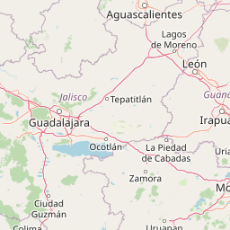
Map view of Pico de Tancítaro Flora and Fauna Protection Area

Use this park location map to pinpoint Pico de Tancítaro Flora and Fauna Protection Area in Mexico, understand its exact geographic position, and read its mapped placement within the surrounding landscape more clearly.

Pigeon | © OpenStreetMap contributors

Location context for Pico de Tancítaro Flora and Fauna Protection Area

Michoacán

Visual reference collection showcasing highland pine-oak forests, stratovolcanic terrain, and protected habitats.

Área de protección de flora y fauna Pico de Tancítaro Landscape Photos and Volcanic Scenery

Photographs capture the diverse volcanic terrain and dense pine-oak forests that define the rugged highlands of Área de protección de flora y fauna Pico de Tancítaro. Detailed visual records offer a clear look at montane ecosystems, rugged ridges, and native habitats across the protected region.

A wide shot showing a mountain range with snow-covered peaks, densely forested slopes, and a small town with red-tiled roofs in the foreground under a blue sky with light clouds.

Park atlas

Compare surrounding highland ecosystems and volcanic landscapes across the regional network

Explore Protected Areas and Parks Near Área de protección de flora y fauna Pico de Tancítaro

Browsing other protected areas near Área de protección de flora y fauna Pico de Tancítaro reveals connected forest habitats and volcanic terrains across Michoacán. Comparing adjacent highland ecosystems provides deeper geographical context for the entire Trans-Mexican Volcanic Belt.
National parkMichoacán
About 23 km away#1 closest

East

Barranca del Cupatitzio National Park: National Park, Michoacán Protected Area

Mapped boundaries and regional geographic context.

Barranca del Cupatitzio National Park stands as a designated national park, providing critical geographic information for atlas exploration. Understand its specific mapped protected area boundaries and discover its role within the regional geography of Michoacán. This profile highlights the park's landscape identity and its significance as a key protected natural site for detailed geographic study.

Area
4.582 km²
Established
1938
IUCN
II
Visitors
255.2K annual
National parkMichoacán
About 54 km away#2 closest

North

Lago de Camécuaro National Park: National Park Protected Landscape and Geographic Atlas

Mapped boundaries and regional natural landscape context for Michoacán.

Lago de Camécuaro National Park offers a focused exploration of a distinct protected area within Michoacán, Mexico. Understand its specific geographic identity through mapped boundaries and regional terrain context, suitable for atlas-based discovery of natural landscapes and conservation areas. This entry provides a factual overview of the park's protected status and its placement within the broader geography of the region.

Area
0.097 km²
Established
1941
IUCN
II
Relief
Upland
Protected areaMichoacán
About 71 km away#3 closest

Northeast

Zacapu Lagoon Protected Area: Mapping the Highland Wetlands of Central Michoacán, Mexico

An endemic-rich spring-fed wetland within the Lerma River basin system

Located in the state of Michoacán, Zacapu Lagoon serves as a vital protected area and perennial wetland. This highland site is defined by its spring-fed waters and riparian vegetation, providing a crucial refuge for narrow-range endemic fish and amphibian species. The lagoon functions as a benchmark for understanding aquatic biodiversity within the complex hydrological network of the Mexican highlands.

Area
0.216 km²
Established
2003
Relief
Lowland
Scope
Terrestrial
A watercolor illustration of a wide lake landscape with distant hills, small green islands, and vegetation in the foreground, painted in soft muted tones.
Protected areaMichoacán
About 73 km away#4 closest

East

Lake Pátzcuaro Protected Area: A Geographic Exploration of the Michoacán Volcanic Basin

Highland volcanic geography and protected wetland ecosystems

Located in a unique endorheic basin at 2,000 metres elevation, Lake Pátzcuaro stands as a landmark of central Mexico. The protected area encompasses dramatic volcanic ridges, expansive marshland fringes, and islands that define the regional geography. Explore the mapped terrain of these highland waters, which serve as a critical ecological corridor and a focal point for understanding the physical and environmental heritage of the Michoacán highlands.

Area
126.4 km²
Relief
Highland
Climate
Temperate
Access
Easy access
A watercolor illustration depicting a wide landscape with green fields, scattered bushes, and rolling hills in the background under a soft pink and yellow sky.
Protected areaMichoacán
About 78 km away#5 closest

Northeast

Alberca de los Espinos: Volcanic Crater and Protected Wetland Geography in Michoacán

Highland crater lake within the Trans-Mexican Volcanic Belt

The protected basin of Alberca de los Espinos forms a striking volcanic landform. Deep within its 2,100-meter crater rim, the lake exhibits complex thermal stratification and seasonal color changes. This site serves as a vital component of the regional geography in Michoacán, blending geological character with recognized wetland status.

Area
1.42 km²
Established
2003
Relief
Upland
Climate
Temperate
Watercolor painting of a wide, calm lake surrounded by low, rolling hills and lush green vegetation under a soft, hazy sky.
Wildlife reserveJalisco
About 123 km away#6 closest

Northwest

Lake Chapala Wildlife Reserve: A Geographic Exploration of Mexico's Largest Freshwater Basin

Highland volcanic landscapes and protected wetland boundaries in Jalisco

Lake Chapala functions as the central hydrological anchor of the Lerma-Santiago watershed. Situated on a high volcanic plateau, this protected wildlife reserve spans a broad valley floor surrounded by dramatic sierras. Gain detailed perspective on its unique endemic fauna, including rare fish species and migratory waterbirds, while navigating the mapped geography of its shoreline, islands, and basin-wide ecological footprint.

Area
1,100 km²
Established
2009
Relief
Mixed relief
Climate
Temperate
National parkJalisco
About 137 km away#7 closest

West

Volcán Nevado de Colima National Park: National Park Protected Landscape Exploration

Mapping the geographic context and protected boundaries.

Delve into the protected landscape identity of Volcán Nevado de Colima National Park, a designated national park in Jalisco, Mexico. This detailed view focuses on its geographic context, providing insights into mapped park boundaries and the natural terrain that defines this significant protected area for comprehensive atlas discovery.

Area
65.55 km²
Established
1936
IUCN
II
Relief
Mountain
Wildlife reserveColima
About 140 km away#8 closest

West

El Jabalí Flora and Fauna Protection Area: Volcanic Terrain and Forest Reserves in Colima

Mapping a diverse protected landscape in western Mexico

Located in the state of Colima, El Jabalí Flora and Fauna Protection Area presents a layered geography of volcanic slopes, pine-oak forests, and high-humidity cloud forest pockets. The area is defined by a series of permanent lagoons and streams that create a vital aquatic refuge. This entry provides a structured look at the physical boundaries and landscape characteristics of this essential Mexican wildlife sanctuary.

Area
51.79 km²
Established
2000
IUCN
VI
Relief
Mountain

Common questions about visiting, size, designation, and location context for Pico de Tancítaro Flora and Fauna Protection Area

Pico de Tancítaro Flora and Fauna Protection Area FAQs for park facts, access, geography, and protected area context

Find quick answers about Pico de Tancítaro Flora and Fauna Protection Area, including protected-area facts, park geography, trail and visitor context, and how the park fits into its surrounding country and regional landscape.
MoriAtlas Explorer

Continue Your Protected Areas Search Across the Global Atlas

Deepen your exploration by continuing the structured search for national parks and protected areas worldwide. Utilize the comprehensive filtering capabilities to compare different conservation landscapes and refine your understanding of global park geography. Discover more about the distribution and characteristics of protected natural areas.

Global natural geography