Mori Atlas logo
Wildlife reservePorcupine Lake Wilderness

Analyzing the terrain and ecological boundaries within the Chequamegon-Nicolet National Forest region

Porcupine Lake Wilderness: Mapping the Protected Forests and Glacial Lake Landscapes of Northern Wisconsin

Porcupine Lake Wilderness serves as a significant protected unit within the broader geography of Bayfield County. This expanse encompasses over ten glacial lakes and ponds, integrated within a mosaic of mixed hardwood and coniferous forests. The area represents a federally designated wilderness, preserving the natural forest architecture and freshwater basins shaped by historic glacial activity in northern Wisconsin.

wilderness areanational forestnorthern Wisconsinforestlakes and pondsglacial landscape

Porcupine Lake Wilderness

Wildlife reserve

Park overview

Structured park overview, official facts, and landscape profile for Porcupine Lake Wilderness

Porcupine Lake Wilderness park facts, protected area profile, and essential visitor context

Review the core facts for Porcupine Lake Wilderness, including designation, size, terrain, visitor scale, habitats, and operating context in one park-focused overview.

About Porcupine Lake Wilderness

Porcupine Lake Wilderness is a federally designated wilderness area in the northern reaches of Wisconsin, situated in Bayfield County near the small community of Drummond. Although small in comparison with many other Wilderness Act areas, the 4,446-acre tract plays a role in preserving the wild, lake-dotted forest character that defines this part of the upper Midwest. The wilderness is entirely contained within the Chequamegon-Nicolet National Forest, one of the largest national forests in Wisconsin, and is managed by the United States Forest Service under the constraints of the National Wilderness Preservation System.

The terrain reflects the glacial history of the region, with shallow lakes, ponds, moraines, and a mix of upland and lowland forest cover. Over ten lakes and ponds are scattered across the wilderness, linked by forested uplands and small streams. The most prominent water body is Porcupine Lake itself, a 71-acre lake with maximum depth of 33 feet and a mean depth of 16 feet, and a bottom composed of sand, gravel, and muck. Other waters such as Eighteen Mile Spring Pond add to the pattern of small, clear lakes and spring-fed ponds typical of the area.

Vegetation in the wilderness is highly characteristic of the transition zone between northern hardwood forest and the coniferous forests further north. Mature stands of oak and maple share the canopy with hemlock and white pine, creating a varied forest mosaic. Because of its wilderness status, the area has been shielded from roads, mechanized use, and timber harvesting, allowing ecological processes and forest succession to proceed largely without active management.

For visitors and researchers, the wilderness offers an accessible but genuine wilderness experience, with opportunities for non-motorized recreation such as hiking, backpacking, and freshwater fishing in lakes that hold trout, bass, and northern pike. Birdlife includes well-known species such as the common loon, which depends heavily on quiet lake environments like those in the wilderness, while mammals such as white-tailed deer, black bear, and red fox complete the picture of a typical northern Wisconsin forest ecosystem.

Quick facts and research context for Porcupine Lake Wilderness

Porcupine Lake Wilderness is a 4,446-acre protected wilderness area in Bayfield County, northern Wisconsin, administered by the United States Forest Service. It sits within the Chequamegon-Nicolet National Forest and was formally designated as wilderness in 1984, placing it under the protections of the National Wilderness Preservation System with an IUCN Category Ib designation. The wilderness contains more than ten named lakes and ponds, with Porcupine Lake itself covering roughly 71 acres and featuring a mixed bottom of sand, gravel, and muck. Forest cover is dominated by oak, maple, hemlock, and white pine, supporting wildlife such as deer, black bear, foxes, and loons, as well as freshwater fish in its lakes.

Protection and recognition

Examine the official terrestrial conservation scope and recognition records

Porcupine Lake Wilderness Protection Status and Territorial Designation

Porcupine Lake Wilderness maintains a documented terrestrial protection scope within the global conservation registry. Official data indexes administrative boundaries and designation frameworks to provide a clear reference for the protected area.

Protection details

Protection scope
Terrestrial
Transboundary protection
No
Park context

Deeper park guide and search-rich context for Porcupine Lake Wilderness

Porcupine Lake Wilderness history, landscape, wildlife, and travel context

Explore Porcupine Lake Wilderness through its history, landscape character, ecosystems, wildlife, conservation priorities, cultural context, and seasonal travel timing in a structured park guide built for atlas discovery and search intent.

Why Porcupine Lake Wilderness stands out

Porcupine Lake Wilderness is best known for being a quiet, lake-rich pocket of northern Wisconsin wilderness embedded within the much larger Chequamegon-Nicolet National Forest. Its defining character comes from the combination of over ten glacial lakes and ponds, a mixed forest of hardwoods and conifers, and the presence of classic northern forest wildlife such as loons, deer, and black bear. The wilderness is also notable as a representative example of the small, federally protected wilderness tracts that dot the Chequamegon-Nicolet landscape, where strict protections preserve the feeling of a roadless, undeveloped forest. Its named feature, Porcupine Lake, is a relatively shallow, gravel-bottomed lake whose character, and the broader lake system surrounding it, gives the wilderness much of its identity.

Porcupine Lake Wilderness history and protected-area timeline

Porcupine Lake Wilderness was formally established in 1984 as a designated Wilderness Area under the National Wilderness Preservation System. Its creation was part of a broader era of wilderness designation in the United States during the 1980s, when additional tracts within already-existing national forests were recognized for their wild, undeveloped character.

Prior to wilderness designation, the land that makes up the wilderness was part of the Chequamegon-Nicolet National Forest and was subject to standard national forest management, including potential timber production and infrastructure development. The 1984 designation removed these heavy uses from the area, imposing restrictions on road-building, logging, and mechanized travel in order to preserve the area's natural conditions.

Since its establishment, the wilderness has been managed by the United States Forest Service with a focus on maintaining wilderness character. It has not undergone major boundary changes and remains a small but stable component of Wisconsin's network of federally protected wilderness areas. The wilderness continues to exist within the broader administrative framework of the Chequamegon-Nicolet National Forest, which handles surrounding land uses while the wilderness core remains under its own stricter protections.

Porcupine Lake Wilderness landscape and geographic character

The landscape of Porcupine Lake Wilderness is shaped by the glacial past of northern Wisconsin, producing a terrain of gentle relief punctuated by lakes, ponds, and forest-covered uplands. The wilderness is far from mountainous or dramatic, but instead offers the quieter, rolling topography typical of the lake country of the upper Midwest, where ice-age processes carved depressions that filled with water and left behind moraines, outwash plains, and pockets of varying soils.

Water is a defining feature of the landscape. The wilderness holds more than ten lakes and ponds, each contributing to a dappled geography of forested shorelines and small open basins. Porcupine Lake, the namesake water body, is a shallow lake with a maximum depth of 33 feet and a mean depth of 16 feet, sitting in a basin whose bottom mixes sand, gravel, and organic muck. Other ponds such as Eighteen Mile Spring Pond add to the impression of a landscape where small, soft-edged lakes and surrounding wetlands alternate with dry upland forest stands.

Between the lakes, the land rises into forested ridges and rolling ground covered by stands of oak, maple, hemlock, and white pine. The combination of conifers and hardwoods gives the wilderness a distinctly northern Wisconsin feel, where pine boughs and broad-leaved trees share the same hillslopes. Streams and seeps linking the lakes and ponds further emphasize the wet character of the terrain.

Overall, the wilderness presents a compact but coherent example of the lake-and-forest landscape that characterizes much of the Chequamegon-Nicolet region. The lack of roads, structures, or large openings within its boundaries preserves the feeling of a continuous, undeveloped forest landscape where lakes appear one after another between the trees.

Porcupine Lake Wilderness ecosystems, habitats, and plant life

Ecologically, Porcupine Lake Wilderness sits at a transition between the northern hardwood forests and the more conifer-dominated forests that lie further north in Wisconsin. The vegetation reflects this transition in its mix of broadleaf and evergreen species, including oak, maple, hemlock, and white pine, which together form a multi-layered, structurally diverse forest over most of the wilderness.

Northern hardwoods such as oak and maple tend to occupy the warmer, drier uplands and ridges, while hemlock and white pine are more prominent on cooler, moister sites, including slopes that border the lakes and ponds. This mosaic supports a wide range of understory plants adapted to different light and soil conditions, and creates forest interiors and edges that are valuable for many wildlife species.

The wilderness's many lakes, ponds, and associated wetlands add an aquatic and semi-aquatic dimension to its ecology. These waters, including Porcupine Lake and Eighteen Mile Spring Pond, support freshwater ecosystems, while shorelines and surrounding wet soils support moisture-loving plants and provide habitat for amphibians, aquatic insects, and the wildlife that depends on lake edges. The presence of spring-fed ponds adds stable, relatively cold water sources that are particularly important for cold-water fish like trout.

The combination of diverse forest types, numerous small lakes, and limited human disturbance makes the wilderness a useful area for preserving ecological processes in northern Wisconsin. Because the area is shielded from active management and development, natural patterns of forest succession, disturbance, and regeneration play out with minimal direct human intervention.

Porcupine Lake Wilderness wildlife and species highlights

Porcupine Lake Wilderness supports a representative cross-section of the wildlife typically associated with the lake forests of northern Wisconsin. Although the area is relatively small, its mix of mature forest, lake edge, and interior habitat provides the resources needed by a variety of mammal, bird, and fish species.

Among mammals, white-tailed deer are common and move readily between forest openings and lakeshore areas. American black bear also use the wilderness, taking advantage of the diverse food sources found in northern forest habitats as well as the relative seclusion provided by the protected area. Red fox and gray fox are also present, often foraging along the edges of lakes and forest stands.

Birdlife includes common loons, which are strongly associated with quiet, forested lakes and are frequently noted for their presence in the wilderness. These birds depend on the area's clear lakes and minimal disturbance for nesting and feeding. Other bird species typical of mixed northern forest, such as a variety of songbirds, raptors, and waterfowl, also occur in the wilderness.

In its lakes and ponds, the wilderness supports populations of freshwater fish. Trout, bass, and northern pike are commonly reported in both Porcupine Lake and Eighteen Mile Spring Pond, reflecting the range of conditions available, from cold, spring-fed waters to warmer, shallower basins. Together, the mammal, bird, and fish communities of the wilderness illustrate the close connection between the area's forest cover and its network of lakes and ponds.

Porcupine Lake Wilderness conservation status and protection priorities

As a designated wilderness within the National Wilderness Preservation System, Porcupine Lake Wilderness is protected under some of the strongest land-conservation provisions in the United States. Its IUCN Category Ib designation recognizes it as a wilderness area where ecological processes, native flora and fauna, and natural features are preserved with a minimum of human intervention.

The primary conservation value of the wilderness lies in the preservation of an intact, roadless tract of northern Wisconsin forest. By prohibiting logging, road construction, mechanized vehicles, and most forms of development, the wilderness designation ensures that forest succession and other ecological processes can proceed largely unimpeded within its boundaries. This is significant in a region where much of the surrounding landscape, even within national forests, is actively managed for timber production and other uses.

The wilderness also plays an important role in protecting freshwater habitats, including its more than ten lakes and ponds. By keeping these waters within a protected, low-disturbance forest setting, the wilderness helps maintain water quality, shoreline integrity, and habitat conditions for aquatic species. The presence of spring-fed ponds such as Eighteen Mile Spring Pond is particularly important for maintaining cold-water conditions that support sensitive fish species like trout.

In the broader context of the Chequamegon-Nicolet National Forest, Porcupine Lake Wilderness functions as one of several protected cores that together preserve samples of the region's original forest and lake character. While modest in size, it contributes to ecological connectivity, biodiversity conservation, and the protection of the wild character that defines this part of the upper Midwest.

Porcupine Lake Wilderness cultural meaning and human context

Porcupine Lake Wilderness lies in a part of northern Wisconsin that has long been characterized by a strong relationship between local communities and the surrounding forests and lakes. Bayfield County and the broader Chequamegon-Nicolet region have histories tied to logging, small-scale farming, fishing, and seasonal use of the land and water, all of which have shaped the cultural identity of nearby communities such as Drummond.

The wilderness does not contain documented major cultural or historic sites within its boundaries, and the predominant cultural context is regional rather than site-specific: an area where forest-based livelihoods, outdoor recreation, and a sense of connection to the Northwoods landscape remain important. The protection of the wilderness itself can be seen as part of a broader regional tradition of valuing the natural and scenic qualities of the lake country.

Today, the wilderness supports a quieter, recreation-oriented cultural connection to the landscape, with visitors using the area for hiking, fishing, and wildlife observation. In this way it continues a longstanding regional pattern of human interaction with northern Wisconsin's forests and lakes, now framed within a strong conservation ethic.

Top sights and standout views in Porcupine Lake Wilderness

Porcupine Lake Wilderness stands out for its combination of more than ten glacial lakes and ponds, mixed hardwood-conifer forest, and protection within the National Wilderness Preservation System. Its compact size and quiet, undeveloped character make it a representative example of small-scale wilderness in the upper Midwest.

The wilderness's namesake Porcupine Lake, with its distinctive sand, gravel, and muck bottom, anchors a broader system of lakes and ponds, of which Eighteen Mile Spring Pond is another notable feature. Wildlife highlights include common loons on the lakes, along with white-tailed deer, black bear, and foxes in the surrounding forest, while the lakes themselves support trout, bass, and northern pike.

Best time to visit Porcupine Lake Wilderness

Visit timing for Porcupine Lake Wilderness is shaped less by formal seasonal openings and more by the natural cycles of northern Wisconsin. Summer is the most accessible season, with longer days, warmer temperatures, stable trails, and fully thawed lakes that are suitable for fishing and swimming. Late spring can also be attractive, with budding trees and active wildlife, though mosquitoes and wet footing are common.

Fall is widely regarded as a particularly rewarding period to visit northern Wisconsin wilderness areas like this one. Cooler temperatures, fewer insects, and dramatic color changes in the hardwood component of the forest create strong scenery, while wildlife such as deer and bear are more active in preparation for winter. Winter brings snow cover that transforms the landscape into a quiet, white forest setting, but access becomes more difficult and requires appropriate skills for cold-weather and snow travel.

For those primarily interested in observing loons, fishing, or simply experiencing the lakes at their most inviting, late spring through early fall offers the broadest window of favorable conditions.
Monthly climate preview

Long-term temperature ranges and monthly precipitation averages for Bayfield County

Porcupine Lake Wilderness Climate Normals and Annual Weather Patterns

Historical NASA climate data for Porcupine Lake Wilderness reveals a wide annual temperature spread alongside measured monthly precipitation normals at a representative elevation of 317 meters. Examining the complete twelve-month profile provides deeper context for long-term regional weather variations across the protected landscape.
Annual mean5 °C
-11 °C20 °C
Jan-11°
Feb-9°
Mar-3°
Apr
May11°
Jun16°
Jul20°
Aug19°
Sep15°
Oct
Nov-1°
Dec-8°
Warmest month
July

19.6 °C

Coolest month
January

-11.4 °C

Wettest month
June

3.6 mm/day

Driest month
January

0.9 mm/day

Park location guide

Geography guide, regional context, and park location map for Porcupine Lake Wilderness

Porcupine Lake Wilderness park geography, regions, and map view in United States of America

Understand where Porcupine Lake Wilderness sits in United States of America through a broader geographic reading of the surrounding landscape, nearby location context, and its mapped position within the national park landscape.

How Porcupine Lake Wilderness fits into United States of America

The United States of America is a federal presidential republic and one of the world's largest countries by area and population. It consists of 50 states across a vast territory spanning multiple time zones, with its capital in Washington, D.C. and largest city in New York City. The nation has a diverse economy, influential political system, and significant cultural and military presence globally.

Wider geography shaping Porcupine Lake Wilderness in United States of America

The United States occupies a vast territory in North America, bordered by Canada to the north and Mexico to the south. The 48 contiguous states stretch from the Atlantic to the Pacific Ocean, while Alaska occupies the northwestern region and Hawaii is an archipelago in the Pacific. The country encompasses diverse terrain including the Rocky Mountains, Appalachian Mountains, Great Plains, and extensive river systems.

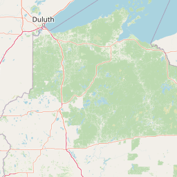
Map view of Porcupine Lake Wilderness

Use this park location map to pinpoint Porcupine Lake Wilderness in United States of America, understand its exact geographic position, and read its mapped placement within the surrounding landscape more clearly.

Pigeon | © OpenStreetMap contributors

Location context for Porcupine Lake Wilderness

Bayfield CountyWisconsin
Park atlas

Compare nearby northern forest reserves, glacial lakes, and regional wilderness tracts

Explore Other Parks Near Porcupine Lake Wilderness and Protected Areas in Wisconsin

Continue geographic comparison by browsing other protected areas sharing the mixed hardwood forests and glacial lake basins of northern Wisconsin. Expanding the regional view reveals connected wilderness tracts and federal forest reserves across the upper Midwest landscape.
Wildlife reserveBayfield County
11 km away#1 closest

Northwest

Rainbow Lake Wilderness: Protected Forest and Lake Mosaic in Bayfield County

Exploration of a designated wildlife reserve in northern Wisconsin

Rainbow Lake Wilderness presents a deeply forested landscape in northern Wisconsin, marked by a high density of sixteen named lakes and numerous ponds. Managed to maintain its natural character, this protected area in Bayfield County provides an essential look at the intersection of glacial geography, old-growth hardwood stands, and quiet aquatic habitats within a larger federal forest context.

Area
28.9 km²
Established
1975
IUCN
Ib
Relief
Upland
Watercolor illustration showing a calm lake with pink and purple reflections, green forested shoreline in the foreground with rocks, and distant hills under a pale sky
Protected landscapeWisconsin
51 km away#2 closest

Northeast

Apostle Islands National Lakeshore: Wisconsin Protected Archipelago and Landscape Map

Geographic overview of sandstone sea caves and wilderness islands.

Apostle Islands National Lakeshore represents a significant protected area within the Great Lakes region of Wisconsin. Composed of twenty-one islands and a mainland shoreline, the landscape is defined by its dramatic red sandstone geology, historic maritime sites, and vast wilderness tracts. This dataset provides a clear view of the lakeshore's boundaries, surrounding water environments, and the interplay between its unique forest ecosystems and Lake Superior.

Area
281.4 km²
Established
1970
IUCN
V
Visitors
253.7K annual
Nature reserveWisconsin
About 87 km away#3 closest

Northwest

Lake Superior National Estuarine Research Reserve: Protected Landscape and Map Context

Freshwater estuarine geography in northwestern Wisconsin

Spanning the confluence of the St. Louis River and Lake Superior, this nature reserve preserves expansive coastal marshland, forested bluffs, and rare sand dune ecosystems. The area serves as a critical freshwater research site within the Great Lakes region, showcasing unique transitions between forest types and complex hydrologic structures shaped by wind driven seiche events.

Area
67.57 km²
Established
2010
Relief
Lowland
Scope
Mixed
A pale, minimalist watercolor painting of a landscape with soft green hills, distant faded mountains, and a small, calm pool of water in the foreground.
Protected landscapeMichigan
About 165 km away#4 closest

East

Ottawa National Forest: Mapped Geography and Protected Landscape Context in Michigan

Glacial watersheds and waterfall corridors of the Upper Peninsula

Ottawa National Forest represents a primary protected landscape within the western Upper Peninsula of Michigan. This atlas entry covers its hydrological significance, ranging from Lake Superior tributaries to regional drainage divides, alongside its role in preserving old-growth white and red pine stands within a broader boreal forest mosaic.

Area
4,020 km²
Established
1931
IUCN
VI
Relief
Upland
National parkKeweenaw County
219 km away#5 closest

Northeast

Isle Royale National Park: Protected Landscape Atlas and Geographic Context

Explore mapped boundaries and natural terrain of this national park.

Isle Royale National Park offers a distinct opportunity for understanding protected landscapes through detailed map exploration. As a national park within Keweenaw County, its geographic identity and mapped boundaries provide valuable context for regional geography and atlas-based discovery. Investigate the natural terrain and protected land features that define this unique area, contributing to a richer comprehension of the surrounding protected areas.

Area
2,314 km²
Established
1940
IUCN
Ib
Visitors
29K annual
Wildlife reserveMichigan
236 km away#6 closest

East

McCormick Wilderness: Protected Forest and Hydrology in Michigan's Upper Peninsula

A federally protected wildlife reserve and river headwaters landscape

Centrally located within the western Upper Peninsula of Michigan, McCormick Wilderness preserves 17,000 acres of dense, regrown northern forest. The area is defined by its unusual density of river headwaters, providing significant ecological value as a quiet, roadless tract within the Ottawa National Forest network.

Area
69 km²
Established
1987
IUCN
Ib
Relief
Upland
National parkMinnesota
243 km away#7 closest

Northwest

Voyageurs National Park: Minnesota's Mapped Protected Landscape and Geography

Explore the atlas context and mapped park boundaries of Voyageurs National Park.

Voyageurs National Park in Minnesota is a key protected area offering rich geographic discovery. As a designated National Park, it provides a unique lens through which to study regional landscapes and mapped natural terrain. Users can delve into its protected boundaries and understand its specific identity within the broader Minnesota geography, making it a vital point for atlas-focused exploration.

Area
883 km²
Established
1975
IUCN
II
Visitors
239.7K annual
A watercolor painting of a rolling, soft-toned landscape with a foreground of green forest and layers of hills receding into the distance.
Protected landscapeUpper Peninsula of Michigan
298 km away#8 closest

East

Hiawatha National Forest: Geographic Overview and Protected Area Map of the Upper Peninsula

Coastal forest landscape and wilderness river corridors.

Hiawatha National Forest spans significant portions of the Upper Peninsula of Michigan, bridging the gap between northern hardwood forests and the boreal environments of the Great Lakes. This protected landscape encompasses extensive shorelines along Lake Superior, Lake Michigan, and Lake Huron, alongside six wilderness areas and five designated wild and scenic rivers.

Area
3,621.27 km²
Established
1931
IUCN
VI
Relief
Lowland

Common questions about visiting, size, designation, and location context for Porcupine Lake Wilderness

Porcupine Lake Wilderness FAQs for park facts, access, geography, and protected area context

Find quick answers about Porcupine Lake Wilderness, including protected-area facts, park geography, trail and visitor context, and how the park fits into its surrounding country and regional landscape.
MoriAtlas Explorer

Continue Your Protected Areas Search Across the Global Atlas

Deepen your exploration by continuing the structured search for national parks and protected areas worldwide. Utilize the comprehensive filtering capabilities to compare different conservation landscapes and refine your understanding of global park geography. Discover more about the distribution and characteristics of protected natural areas.

Global natural geography