Mori Atlas logo
Wildlife reservePortobello Creek National Wildlife Area

A vital protected wetland reserve in New Brunswick featuring expansive marshland and riverine ecosystems.

Portobello Creek National Wildlife Area: Mapping the Saint John River Floodplain Landscapes

(Réserve nationale de faune de Portobello Creek)

Portobello Creek National Wildlife Area encompasses a significant portion of the Saint John River floodplain, representing one of the most extensive wetland systems in the Maritime provinces. This protected landscape preserves a mosaic of open marshes, shrub swamps, and wooded floodplain forests, providing essential habitat within the Sheffield Jemseg sector. Through this atlas, visualize the terrain and geographic boundaries that define this important conservation area east of Fredericton.

wetlandsfloodplainrivermarshlandbirdwatchingmigratory birds

Portobello Creek National Wildlife Area

Wildlife reserve

Park overview

Structured park overview, official facts, and landscape profile for Portobello Creek National Wildlife Area

Portobello Creek National Wildlife Area park facts, protected area profile, and essential visitor context

Review the core facts for Portobello Creek National Wildlife Area, including designation, size, terrain, visitor scale, habitats, and operating context in one park-focused overview.

About Portobello Creek National Wildlife Area

Portobello Creek National Wildlife Area occupies a strategic position in the broader Saint John River watershed of south-central New Brunswick. The reserve is situated just east of Fredericton, New Brunswick's capital, and extends across Portobello Creek in an area defined by the wide, flat floodplain of the Saint John River. To the east lie Indian Lake and French Lake, two large lakes that frame the reserve's eastern boundary and contribute to the hydrological character of the surrounding landscape.

As a federal National Wildlife Area, the site is managed primarily for wildlife conservation rather than recreation or resource extraction. It is one of five such reserves in New Brunswick and is administered by the Canadian Wildlife Service, the federal agency responsible for migratory birds, habitat protection, and biodiversity stewardship. The reserve borders the Grand Lake Natural Area, reinforcing the protected status of a substantial corridor of wetland and lake habitat in the region.

The ecological importance of Portobello Creek lies in its representation of floodplain processes. The Saint John River floodplain is one of the largest wetland complexes in the Maritime provinces, and Portobello Creek captures many of its defining features in a relatively compact federal reserve. Open marshes, shrub-dominated swamps, wooded back swamps, and riparian forests intermingle across the site, creating habitat for breeding, feeding, and migrating waterfowl and shorebirds. Because floodplain wetlands of this scale have become increasingly rare and altered in eastern Canada, the reserve plays a meaningful role in the regional conservation network.

Quick facts and research context for Portobello Creek National Wildlife Area

Portobello Creek National Wildlife Area is a 21.54 square kilometre federal wildlife reserve located in Sunbury County, New Brunswick, immediately east of Fredericton. It sits within the Saint John River floodplain, spanning Portobello Creek and the lowlands west of Indian Lake and French Lake, with the area divided between open marsh, shrub swamp, wooded swamp, and floodplain forest.

The reserve is classified as a strict nature reserve under IUCN Category Ia and is one of the five National Wildlife Areas in New Brunswick. It falls within the Saint John River Important Bird Area (Sheffield–Jemseg sector) and borders the protected Grand Lake Natural Area. It was established on 5 April 1995 and is administered by the Canadian Wildlife Service.

Protection and recognition

Documented terrestrial protection metrics and official conservation status records

Portobello Creek National Wildlife Area Protection Status and Formal Recognition Data

Portobello Creek National Wildlife Area preserves a dedicated terrestrial protection scope without supplementary international recognition programs. Official database records outline the conservation framework and administrative designation details.

Protection details

Protection scope
Terrestrial
Transboundary protection
No
WDPA ID
18180
Park context

Deeper park guide and search-rich context for Portobello Creek National Wildlife Area

Portobello Creek National Wildlife Area history, landscape, wildlife, and travel context

Explore Portobello Creek National Wildlife Area through its history, landscape character, ecosystems, wildlife, conservation priorities, cultural context, and seasonal travel timing in a structured park guide built for atlas discovery and search intent.

Why Portobello Creek National Wildlife Area stands out

Portobello Creek National Wildlife Area is best known for protecting a substantial stretch of the Saint John River floodplain, a wetland system that ranks among the most extensive in the Maritime provinces. The reserve's combination of open marsh, shrub swamp, wooded swamp, and floodplain forest creates a varied habitat mosaic that supports breeding populations of marsh-nesting waterbirds, including the Yellow Rail, Black Tern, and Greater Scaup. Its inclusion in the Saint John River Important Bird Area, in the Sheffield, Jemseg sector, and its proximity to the Greater Fredericton region also make it a recognized site for avian conservation in Atlantic Canada.

Portobello Creek National Wildlife Area history and protected-area timeline

Portobello Creek National Wildlife Area was officially created on 5 April 1995 as a federal protected area under the authority of the Canadian Wildlife Service. Its designation followed a period in which the ecological importance of the Saint John River floodplain became increasingly recognized in the context of migratory bird conservation and wetland habitat protection in Atlantic Canada.

The reserve's establishment aligned it with the broader Canadian National Wildlife Area system, which was developed to safeguard representative examples of Canada's wildlife habitats under federal jurisdiction. By placing the site within the Sheffield–Jemseg sector of the Saint John River Important Bird Area, its recognition tied floodplain habitat conservation directly to international frameworks for the protection of migratory birds and important bird areas.

Over time, the reserve's location within an evolving regional network, defined by the adjacent Grand Lake Natural Area and ongoing watershed management efforts around the Saint John River, has reinforced its significance as a conservation anchor for south-central New Brunswick.

Portobello Creek National Wildlife Area landscape and geographic character

The landscape of Portobello Creek National Wildlife Area is defined entirely by the geomorphic character of the Saint John River floodplain. Topography across the reserve is low and flat, shaped by repeated cycles of flooding and sediment deposition that have produced a rich mosaic of wetland landforms. Portobello Creek, the watercourse that gives the reserve its name, runs through the site and connects the broader floodplain to the Saint John River.

To the east of the reserve lie Indian Lake and French Lake, large freshwater bodies whose open water and shoreline habitats extend the wetland landscape beyond the reserve's boundaries. West of the reserve, toward Fredericton, the urban and peri-urban surroundings contrast with the comparatively undeveloped floodplain habitat inside the protected area.

The visible landscape is therefore one of expansive, gently graded terrain dominated by marsh vegetation, shrub thickets, and low-lying forests. Seasonal flooding by the Saint John River is a defining process, periodically reshaping the channels, pools, and vegetation patterns that give the reserve its ecological character and scenic identity.

Portobello Creek National Wildlife Area ecosystems, habitats, and plant life

Ecologically, Portobello Creek National Wildlife Area is a textbook example of a temperate river floodplain wetland complex. The reserve's vegetation reflects the hydrological gradient between frequently flooded open water, seasonally inundated marshes, and higher-ground forested areas that flood less often.

Open marshes dominate the wettest portions of the site, with emergent grasses, sedges, and aquatic plants providing nesting cover and foraging habitat for waterbirds. Shrub swamps form a transitional zone, characterized by dense thickets of willows and other moisture-tolerant shrubs. Wooded swamps and floodplain forests cover the better-drained rises, supporting a mix of hardwood and softwood species adapted to periodic saturation.

This combination of habitats, replicated across much of the Saint John River floodplain, supports both resident wildlife and species that depend on the river corridor for migration and breeding. The reserve's ecological value lies less in any single habitat type than in the integrated mosaic and the continued functioning of the underlying floodplain processes.

Portobello Creek National Wildlife Area wildlife and species highlights

The wildlife profile of Portobello Creek National Wildlife Area is shaped by its floodplain and wetland character. The reserve carries particular significance for breeding birds, and is identified as a key component of the Saint John River Important Bird Area in the Sheffield–Jemseg sector.

Among the most notable breeding species recorded on the site are the Yellow Rail, a secretive marsh-nesting rail associated with extensive sedge marshes, the Black Tern, which nests colonially over freshwater marshes and feeds on small fish and aquatic invertebrates, and the Greater Scaup, a diving duck that breeds in wetland complexes across boreal and Atlantic Canada. The presence of these species underscores the importance of the reserve's open marsh and shallow water habitats during the breeding season.

Beyond these featured species, the reserve's mix of marsh, swamp, and floodplain forest provides habitat for typical wetland and riparian wildlife, including other waterfowl, wading birds, and songbirds associated with shrubby wetlands. Mammals, fish, and amphibians typical of Saint John River floodplain habitats are also part of the broader ecological community supported by the reserve.

Portobello Creek National Wildlife Area conservation status and protection priorities

Portobello Creek National Wildlife Area was established to conserve a representative portion of the Saint John River floodplain and the wildlife that depends on it. Managed as a strict nature reserve under IUCN Category Ia, the site emphasizes habitat protection over other uses and is administered by the Canadian Wildlife Service.

Its inclusion in the Saint John River Important Bird Area, specifically the Sheffield–Jemseg sector, gives the reserve a recognized role within international bird conservation networks. Important Bird Areas are identified based on standardized criteria tied to the presence of vulnerable or threatened species, congregatory populations, or restricted-range species, and the reserve's designation reflects the documented significance of the floodplain for breeding waterbirds.

By protecting floodplain marshes, swamps, and forests in a region where wetland loss and alteration have been ongoing concerns, the reserve contributes to landscape-scale conservation in south-central New Brunswick. Its proximity to the Grand Lake Natural Area further reinforces its conservation value as part of a broader network of protected lake and wetland habitats in the province.

Top sights and standout views in Portobello Creek National Wildlife Area

Portobello Creek National Wildlife Area stands out in New Brunswick for the scale and ecological integrity of its floodplain wetland habitats, particularly its open marshes and shallow wetland communities that support priority breeding birds. Its integration with the Saint John River Important Bird Area and adjacency to the Grand Lake Natural Area also give it strong regional conservation significance.

The reserve's accessibility from Fredericton, combined with its landscape-scale floodplain context, makes it both a local conservation landmark and a contributor to wetland and waterbird protection across the Maritime provinces.

Best time to visit Portobello Creek National Wildlife Area

The reserve is best experienced in late spring and summer, when the Saint John River floodplain comes alive with breeding waterbirds and lush wetland vegetation. Late May through July is typically the most rewarding window for observing marsh-nesting species such as the Yellow Rail, Black Tern, and Greater Scaup, which are active on the site during the breeding season.

Early morning visits during this period tend to offer the richest bird activity, while cooler weather typically reduces mosquito and biting insect pressure. Outside the breeding season, the reserve's open landscape can also be visited for general appreciation of the floodplain mosaic, though the marquee wildlife experiences are concentrated in the warmer months.

Monthly climate preview

Long term monthly temperature and precipitation rhythm for New Brunswick

Portobello Creek National Wildlife Area Climate and Temperature Normals

Representative coordinate measurements reveal the multiyear temperature progression and precipitation pattern spanning twelve recorded months. Analyzing the complete numerical climatology profile provides precise baseline data for this protected area.
Annual mean5 °C
-10 °C19 °C
Jan-10°
Feb-9°
Mar-3°
Apr
May11°
Jun16°
Jul19°
Aug19°
Sep14°
Oct
Nov
Dec-5°
Warmest month
July

19.1 °C

Coolest month
January

-9.8 °C

Wettest month
October

3.6 mm/day

Driest month
February

2.6 mm/day

Park location guide

Geography guide, regional context, and park location map for Portobello Creek National Wildlife Area

Portobello Creek National Wildlife Area park geography, regions, and map view in Canada

Understand where Portobello Creek National Wildlife Area sits in Canada through a broader geographic reading of the surrounding landscape, nearby location context, and its mapped position within the national park landscape.

How Portobello Creek National Wildlife Area fits into Canada

Canada is a federal parliamentary constitutional monarchy spanning North America from the Atlantic to the Pacific and Arctic Oceans. With a population of over 41 million, it is officially bilingual in English and French at the federal level. The country gained independence from the United Kingdom through a gradual process culminating in 1982.

Wider geography shaping Portobello Creek National Wildlife Area in Canada

Canada occupies the northern portion of North America, sharing its longest international border with the United States. The country extends from the Atlantic Ocean to the Pacific Ocean and northward into the Arctic Ocean, giving it the longest coastline of any nation.

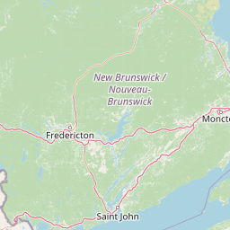
Map view of Portobello Creek National Wildlife Area

Use this park location map to pinpoint Portobello Creek National Wildlife Area in Canada, understand its exact geographic position, and read its mapped placement within the surrounding landscape more clearly.

Pigeon | © OpenStreetMap contributors

Location context for Portobello Creek National Wildlife Area

New Brunswick
Park atlas

Compare adjacent wetland habitats and protected landscapes across the Saint John River basin.

Parks Near Portobello Creek National Wildlife Area and Regional Protected Areas

Browse other national wildlife areas and protected river floodplains located across the surrounding region. Comparing adjacent wetland terrain provides deeper geographic context for regional bird conservation and freshwater habitats.
National parkNew Brunswick
About 96 km away#1 closest

East

Fundy National Park: New Brunswick National Park Atlas and Geographic Exploration

Mapped protected landscape and regional park context.

Fundy National Park represents a vital protected area, offering rich geographic discovery within New Brunswick, Canada. This national park detail provides context for its mapped boundaries and landscape, supporting atlas-based exploration of its regional significance. Understand Fundy National Park's protected status and its contribution to the mapped natural terrain of eastern Canada.

Area
207 km²
Established
1948
IUCN
II
Visitors
303.6K annual
Watercolor painting of a coastal landscape with green marshlands in the foreground, water, and soft, warm-toned rolling hills in the background.
Wildlife reserveNew Brunswick
About 124 km away#2 closest

East

Réserve nationale de faune de Shepody: Geographic Overview of a New Brunswick Wildlife Reserve

Coastal wetlands and protected intertidal geography

Located along the Bay of Fundy, Réserve nationale de faune de Shepody represents an essential network of salt marshes and freshwater habitats. This mapping analysis traces the intersection of tidal dynamics, riverine estuaries, and ancient sandstone formations that define this critical protected area in New Brunswick.

Area
10.69 km²
Established
1980
IUCN
IV
Relief
Lowland
A minimalist watercolor illustration showing soft green hills in the distance, a calm body of water, and stylized reddish vegetation in the foreground.
Wildlife reserveNova Scotia
About 127 km away#3 closest

Southeast

Île Haute Wildlife Reserve: Mapped Volcanic Geography and Coastal Protected Terrain

Bay of Fundy protected area, Nova Scotia

Rising abruptly from the Bay of Fundy, Île Haute features a steep, isolated plateau encircled by 100-meter basalt cliffs. This wildlife reserve showcases Jurassic volcanic geology and provides essential habitat for migratory seabirds and marine mammals. Gain insights into the island's unique coastal geography and its role as a protected natural sanctuary in Atlantic Canada.

Area
0.8 km²
Established
2025
Relief
Upland
Scope
Mixed
National parkNew Brunswick
About 138 km away#4 closest

Northeast

Kouchibouguac National Park: New Brunswick Protected Landscape Atlas

Mapped protected area boundaries and regional geography.

Kouchibouguac National Park is a designated national park offering a rich canvas for geographic discovery. This entry focuses on understanding its protected landscape, detailing its specific mapped boundaries within New Brunswick. It serves as a vital component for atlas exploration, providing the context needed to grasp the park's natural terrain and its significance within the regional geography.

Area
238 km²
Established
1969
IUCN
II
Visitors
243.5K annual
Watercolor painting of a tranquil marshy wetland with calm water, sparse dead trees, and distant hills under a light, hazy sky.
Wildlife reserveNova Scotia
About 162 km away#5 closest

East

Amherst Point Migratory Bird Sanctuary: Wetland Protected Landscape and Map Explorer

Nova Scotia Wildlife Reserve and Managed Marshland Habitat

Amherst Point Migratory Bird Sanctuary protects a significant freshwater marsh and ponded wetland network in Nova Scotia. This reserve is defined by its engineered diked impoundments and role as a crucial stopover for migratory birds in the Atlantic flyway, offering a clear window into managed wetland conservation and coastal marsh terrain.

Area
4.33 km²
Established
1947
IUCN
IV
Wildlife reserveNova Scotia
About 165 km away#6 closest

Southeast

Kentville Migratory Bird Sanctuary: A Protected Wetland Reserve in the Cornwallis River Valley

Mapped riparian ecosystems and migratory bird habitats in Nova Scotia.

Discover the unique geography of the Kentville Migratory Bird Sanctuary, a compact wildlife reserve in Nova Scotia. This protected area features a blend of river channels, open fields, and forest mosaic that serves as a seasonal sanctuary for waterfowl. Learn about the riparian terrain that defines this critical node in the broader Atlantic flyway network.

Area
5.06 km²
Established
1939
Relief
Lowland
Scope
Terrestrial
Wildlife reserveNew Brunswick
About 171 km away#7 closest

Northeast

Île-du-Portage National Wildlife Area: Geographic Overview and Protected Island Mapping

A vital estuarine reserve on the New Brunswick coast

Study the coastal terrain of Île-du-Portage National Wildlife Area, an uninhabited island reserve situated at the junction of the Miramichi River and the Northumberland Strait. This overview focuses on the island's role as one of five National Wildlife Areas in New Brunswick, highlighting its significance within the broader estuarine geography and coastal maritime history of the Atlantic region.

Area
3.49 km²
Established
1979
IUCN
Ia
Relief
Lowland
Watercolor painting showing a river landscape with green trees, rolling hills, and mountains in the background
National parkNova Scotia
About 178 km away#8 closest

Southeast

Kejimkujik National Park: Detailed Protected Landscape and Regional Geography

Explore mapped boundaries and geographic context in Nova Scotia.

Kejimkujik National Park offers a dedicated entry for understanding protected natural areas. As a national park in Nova Scotia, its geographic features and protected boundaries are detailed here to support atlas-based exploration. Discover the park's unique landscape context and its positioning within regional geography, providing a factual basis for comprehending its role as a conservation area.

Area
404 km²
Established
1967
IUCN
II
Visitors
75.3K annual

Common questions about visiting, size, designation, and location context for Portobello Creek National Wildlife Area

Portobello Creek National Wildlife Area FAQs for park facts, access, geography, and protected area context

Find quick answers about Portobello Creek National Wildlife Area, including protected-area facts, park geography, trail and visitor context, and how the park fits into its surrounding country and regional landscape.
MoriAtlas Explorer

Continue Your Protected Areas Search Across the Global Atlas

Deepen your exploration by continuing the structured search for national parks and protected areas worldwide. Utilize the comprehensive filtering capabilities to compare different conservation landscapes and refine your understanding of global park geography. Discover more about the distribution and characteristics of protected natural areas.

Global natural geography