Mori Atlas logo
Wildlife reserveRaccoon Branch Wilderness

Mapping the rugged ridgelines, incised stream corridors, and old growth forests of Virginia

Raccoon Branch Wilderness: A Protected Wildlife Reserve in the Southern Blue Ridge Mountains

Raccoon Branch Wilderness spans over 4,200 acres of protected terrain within the Mount Rogers National Recreation Area. This high-relief landscape features quartzite-capped summits along Dickey and Bobbys Ridges, providing a critical watershed for the Holston River basin. The area protects a significant range of Appalachian biological diversity, from rare highland flora to vital aquatic habitats, within a preserved backcountry environment that defines the highland character of southwestern Virginia.

Appalachian wildernessSouthern Blue Ridgeforested ridgescold-water streamsold-growth forestAppalachian Trail

Raccoon Branch Wilderness

Wildlife reserve

Park overview

Structured park overview, official facts, and landscape profile for Raccoon Branch Wilderness

Raccoon Branch Wilderness park facts, protected area profile, and essential visitor context

Review the core facts for Raccoon Branch Wilderness, including designation, size, terrain, visitor scale, habitats, and operating context in one park-focused overview.

About Raccoon Branch Wilderness

Raccoon Branch Wilderness is a small but ecologically significant component of America's eastern wilderness system, tucked into the far northwest corner of the Mount Rogers National Recreation Area in southwestern Virginia. Encompassing roughly 4,225 acres of forest, ridges, and mountain streams, the wilderness was designated by Congress in 2009 under the Eastern Wilderness Act, marking it as one of the most recent additions to Virginia's protected wilderness inventory. The area is managed by the U.S. Forest Service within the larger Mount Rogers Cluster, a grouping of adjoining national forest and recreation lands centered on the high country of the southern Appalachians.

Geographically, the wilderness lies near the community of Sugar Grove in Smyth County, with the nearest larger city being Abingdon to the west. Bounded on the east by Virginia Route 16 and on the west by State Route 650, the area is accessible by well-maintained trail corridors rather than by roads into its interior. About 4.5 miles of the Appalachian Trail cross the wilderness, supplemented by segments of the Virginia Highlands Trail and several shorter Forest Service spur trails that link hollows, ridges, and stream crossings.

From an ecological standpoint, Raccoon Branch Wilderness occupies part of the Southern Blue Ridge Subsection of the Central Appalachian Broadleaf Coniferous Forest-Meadow Province. Its forests include mixed oaks, hickories, tulip trees, hemlocks, basswood, and pockets of Fraser fir in the upper elevations, with possibly around 268 acres of inventoried old-growth trees. Both Dickey Ridge and Bobbys Ridge anchor the topography, and the wilderness captures the full watersheds of Raccoon Branch, Scott Branch, and several smaller tributaries that eventually drain into the Holston River, supporting downstream aquatic species such as endangered freshwater mussels. The result is a relatively compact but unusually representative slice of Appalachian wilderness.

Quick facts and research context for Raccoon Branch Wilderness

Raccoon Branch Wilderness is located in the northwest corner of the Mount Rogers National Recreation Area in Smyth County, Virginia, near the town of Sugar Grove. The nearest city is Abingdon. The wilderness covers about 4,225 acres, was designated by Congress in 2009, and is administered by the U.S. Forest Service as part of the Eastern Wilderness Act system. Its elevation ranges from roughly 2,580 to 4,019 feet, and it is classified under IUCN Category Ib as a wilderness area.

Protection and recognition

Documented terrestrial protection scope and international recognition facts

Raccoon Branch Wilderness Protection Status and Recognition Data

Raccoon Branch Wilderness maintains a documented terrestrial protection scope within its designated conservation boundaries. Official records track available designation history, management scope, and international recognition sources without assuming external outcomes.

Protection details

Protection scope
Terrestrial
Transboundary protection
No
Park context

Deeper park guide and search-rich context for Raccoon Branch Wilderness

Raccoon Branch Wilderness history, landscape, wildlife, and travel context

Explore Raccoon Branch Wilderness through its history, landscape character, ecosystems, wildlife, conservation priorities, cultural context, and seasonal travel timing in a structured park guide built for atlas discovery and search intent.

Why Raccoon Branch Wilderness stands out

Raccoon Branch Wilderness is best known for its rugged Southern Blue Ridge terrain, with two long parallel ridges; Dickey Ridge and Bobbys Ridge; shaped by ancient quartzite-capped uplifts and deeply incised cold-water streams. The area preserves portions of old-growth Appalachian forest and rare highland plant species such as Fraser fir, painted trillium, small purple-fringed orchids, and the unusual Appalachian club moss. The wilderness is also notable for protecting the full watershed of Raccoon Branch and Scott Branch and for supporting aquatic biodiversity downstream, including habitat for the Tennessee pigtoe mussel and the Tennessee heelsplitter in the Holston River system. Together, these landscape and ecological qualities make the area a meaningful addition to Virginia's network of protected backcountry.

Raccoon Branch Wilderness history and protected-area timeline

Since Raccoon Branch Wilderness was only formally designated in 2009, its official administrative history is relatively recent. The area was identified within the Mount Rogers National Recreation Area as a landscape with significant wilderness qualities: intact forest cover, undisturbed headwater streams, old-growth stands, and rare plant and animal occurrences. Congressional designation under the Eastern Wilderness Act brought the area into the National Wilderness Preservation System, giving it the same legal protections long applied to older western wilderness areas and committing it to be maintained in its present natural condition.

Following designation, the U.S. Forest Service took on management responsibility through the Mount Rogers National Recreation Area framework. Management regulations reflect the wilderness character: motorized equipment and vehicles are prohibited, mountain bikes are not permitted, group sizes are limited to ten people, and camping conditions are restricted to preserve the area's undeveloped condition. The Hurricane and Raccoon Branch campgrounds located just outside the wilderness boundary provide more developed overnight options for visitors who want to access the area on foot. As one of Virginia's newest wilderness areas, Raccoon Branch represents a continuing commitment to preserving representative eastern Appalachian ecosystems within the National Wilderness Preservation System.

Raccoon Branch Wilderness landscape and geographic character

Raccoon Branch Wilderness sits within the Southern Blue Ridge Mountains Subsection of the broader Appalachian chain, where ancient uplifts of igneous and metamorphic rock have been carved by erosion into a rugged, dissected terrain. Two long ridges; Dickey Ridge running through the western side of the area and Bobbys Ridge to its east; form the dominant topographic framework. Dickey Ridge carries the area's highest elevations, including High Point at 4,019 feet and Dickey Knob at about 3,606 feet, while lower boundary elevations drop to roughly 2,580 feet along SR 650 in the northwest corner.

The ridges are capped by resistant Cambrian quartzite, which has eroded unevenly over time to produce dramatic elevation contrasts and steep gradients. Streams draining the wilderness have cut deeply into the underlying rock, creating numerous high-gradient, incised channels that flow into Dickey Creek, Comers Creek, and ultimately the Holston River. A notable 300-foot rock slide area on the eastern boundary has, over time, stabilized enough for small pines to begin recolonizing its surface.

The result is a landscape of long forested ridgelines, deep hollows, and quiet, fast-flowing streams. Despite its modest total size, the wilderness feels expansive because of the topographic relief and the unbroken forest cover that extends from low valley bottoms to exposed mountain summits.

Raccoon Branch Wilderness ecosystems, habitats, and plant life

Ecologically, Raccoon Branch Wilderness is part of the Central Appalachian Broadleaf Coniferous Forest-Meadow Province, and it preserves a broad spectrum of Appalachian forest communities within a relatively compact footprint. Mid and lower elevation forests are dominated by a mix of red oak, white oak, scarlet oak, chestnut oak, shagbark hickory, white ash, tulip trees, basswood, cucumber tree, striped maple, walnut, and hemlock, which thrive in the cooler, moister valley and hollow environments. At higher elevations on the ridges, conditions become suitable for Fraser fir, lending the upper reaches a more boreal character unusual for the southern Appalachians.

Within these forests, around 268 acres have been inventoried as old growth, providing rare structural and ecological complexity within the broader managed national forest landscape. The herb layer supports a diverse and ecologically interesting flora, including painted trillium and small purple-fringed orchids in bloom, broad beech ferns in shaded draws, and squawroot, a parasitic plant that feeds on oak roots and serves as an important early spring food source for black bears emerging from hibernation. Two particularly rare species; the Appalachian club moss (Huperzia appalachiana) and the five-rowed peat moss (Sphagnum quinquefarium) - have been documented here, adding botanical significance to the wilderness.

Aquatic and riparian habitats are equally important. The cold, clean headwater streams draining the wilderness sustain assemblages of native Appalachian aquatic life and feed larger downstream systems such as Dickey Creek, Comers Creek, and the Holston River. These waters ultimately support broader aquatic biodiversity, including two endangered mussel species, the Tennessee pigtoe and the Tennessee heelsplitter, whose habitat begins in undisturbed headwaters like those preserved in Raccoon Branch.

Raccoon Branch Wilderness wildlife and species highlights

Wildlife in Raccoon Branch Wilderness reflects the broader richness of the southern Appalachian high country. Black bears are among the most ecologically significant residents, using squawroot and other early spring resources as they emerge from hibernation. The unbroken forest cover and remote hollows also support typical Appalachian forest fauna, including white-tailed deer, wild turkey, and a range of smaller mammals and songbirds characteristic of mature eastern deciduous and mixed conifer-hardwood forests.

Birdlife includes species typical of high-elevation Appalachian habitats, and the area supports the yellow-bellied sapsucker, which is considered rare in Virginia. Beyond birds, the wilderness is notable for aquatic and invertebrate diversity. Nelson's early black stonefly, a rare insect species, has been documented in local streams, and the cold, well-oxygenated waters of tributaries within the wilderness provide habitat for the black sculpin (Cottus baileyi), a small fish of conservation interest in the southern Appalachians.

Downstream, the conservation value of the wilderness expands: because Raccoon Branch and Scott Branch feed into the Holston River system, the protected watersheds contribute to habitat for two federally endangered freshwater mussels, the Tennessee pigtoe and the Tennessee heelsplitter. This indirect protection of aquatic species across a much larger river system highlights the disproportionate ecological value of small, high-quality wilderness headwaters.

Raccoon Branch Wilderness conservation status and protection priorities

Raccoon Branch Wilderness plays a meaningful role in eastern conservation as one of the newest members of the National Wilderness Preservation System. Designated in 2009 under the Eastern Wilderness Act, it adds to the system of Appalachian protected areas that together safeguard over half of the ecosystems found in the United States. By preserving intact forest cover, old-growth stands, and undisturbed headwater streams, the wilderness maintains ecological processes that have been altered across much of the surrounding landscape.

From a water-quality perspective, the area's importance extends well beyond its boundaries. As the headwaters of tributaries that feed Dickey Creek, Comers Creek, and ultimately the Holston River, the wilderness acts as a natural filter, supplying clean, cold, well-oxygenated water to downstream aquatic systems that support endangered species like the Tennessee pigtoe mussel and the Tennessee heelsplitter. Protecting these watersheds helps maintain the resilience of freshwater biodiversity throughout the broader river system.

The wilderness also preserves rare species and habitats at the local level, from the uncommon Appalachian club moss and five-rowed peat moss to the rare Nelson's early black stonefly, the yellow-bellied sapsucker, and the black sculpin. Strict regulations limiting motorized access, mechanized equipment, mountain bikes, and group size help ensure that the area remains in its natural condition, fulfilling the long-term conservation purpose Congress intended when adding it to the national wilderness system.

Top sights and standout views in Raccoon Branch Wilderness

Raccoon Branch Wilderness concentrates a remarkable range of Appalachian wilderness qualities into a compact area: long quartzite-capped ridges, deeply incised cold-water streams, scattered old-growth forest, rare highland flora such as Fraser fir and Appalachian club moss, and habitat for species of conservation concern ranging from black bears and yellow-bellied sapsuckers to the black sculpin and endangered downstream mussels.

The wilderness also serves as a quiet outdoor recreation area, crossed by about 4.5 miles of the Appalachian Trail and segments of the Virginia Highlands Trail, with additional Forest Service trails providing access to ridges and hollows. Combined with its proximity to the Mount Rogers National Recreation Area and its role within the Mount Rogers Cluster, the wilderness offers a representative and accessible example of southern Appalachian wilderness character.

Best time to visit Raccoon Branch Wilderness

As a forested Appalachian wilderness with elevations from the high 2,000s to around 4,000 feet, Raccoon Branch Wilderness is best experienced during the warmer months of late spring, summer, and early fall, when trail conditions are generally drier and streams are easier to ford. Spring brings blooming wildflowers such as painted trillium and small purple-fringed orchids, making it a particularly appealing season for botanical interest, while fall offers strong displays of foliage color across the oak and hickory forests.

Winter can bring snow and ice to the higher ridges, especially along the Appalachian Trail and the exposed sections of Dickey Ridge, so visitors in colder months should be prepared for winter conditions. Because the wilderness prohibits motorized equipment and limits group size, visits at any time of year tend to be quiet and low-impact, supporting an experience centered on the natural rather than developed character of the area.
Monthly climate preview

Long-term representative monthly averages for temperature and precipitation

Raccoon Branch Wilderness Climate Normals and Annual Temperature Patterns

Representative coordinates outline measured annual temperature variations and monthly precipitation averages across Raccoon Branch Wilderness from 1991 to 2020. Reviewing the complete twelve-month climatology profile reveals deeper multi-year weather trends and long-term environmental rhythms for the protected landscape.
Annual mean11 °C
0 °C22 °C
Jan
Feb
Mar
Apr11°
May16°
Jun20°
Jul22°
Aug22°
Sep18°
Oct12°
Nov
Dec
Warmest month
July

22.4 °C

Coolest month
January

0 °C

Wettest month
June

3.7 mm/day

Driest month
October

2.7 mm/day

Park location guide

Geography guide, regional context, and park location map for Raccoon Branch Wilderness

Raccoon Branch Wilderness park geography, regions, and map view in United States of America

Understand where Raccoon Branch Wilderness sits in United States of America through a broader geographic reading of the surrounding landscape, nearby location context, and its mapped position within the national park landscape.

How Raccoon Branch Wilderness fits into United States of America

The United States of America is a federal presidential republic and one of the world's largest countries by area and population. It consists of 50 states across a vast territory spanning multiple time zones, with its capital in Washington, D.C. and largest city in New York City. The nation has a diverse economy, influential political system, and significant cultural and military presence globally.

Wider geography shaping Raccoon Branch Wilderness in United States of America

The United States occupies a vast territory in North America, bordered by Canada to the north and Mexico to the south. The 48 contiguous states stretch from the Atlantic to the Pacific Ocean, while Alaska occupies the northwestern region and Hawaii is an archipelago in the Pacific. The country encompasses diverse terrain including the Rocky Mountains, Appalachian Mountains, Great Plains, and extensive river systems.

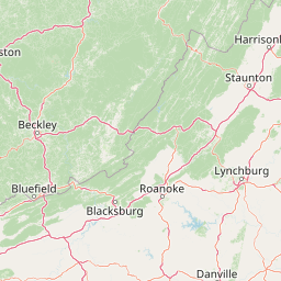
Map view of Raccoon Branch Wilderness

Use this park location map to pinpoint Raccoon Branch Wilderness in United States of America, understand its exact geographic position, and read its mapped placement within the surrounding landscape more clearly.

Pigeon | © OpenStreetMap contributors

Location context for Raccoon Branch Wilderness

Smyth CountyVirginia
Recorded earthquake history

Review Recorded Earthquake History for Raccoon Branch Wilderness

Explore the historical catalogue of seismic events recorded in the vicinity of Raccoon Branch Wilderness. Use these USGS-sourced records to view past earthquake data, magnitudes, and proximity patterns across the Southern Blue Ridge landscape.

Raccoon Branch Wilderness Earthquake History

Catalogued events

5 events

Strongest magnitude

Magnitude 5.1

Most recent event

Aug 9, 2020

This history includes earthquakes recorded inside the park or within 50 km of its borders

Park atlas

Compare surrounding Southern Blue Ridge wildlands and connected highland terrain.

Other Parks Near Raccoon Branch Wilderness and Protected Areas in the Region

Browse nearby national parks and protected areas sharing the rugged terrain of Raccoon Branch Wilderness. Comparing adjacent conservation landscapes reveals broader ecological patterns across the Southern Blue Ridge mountains.
Wildlife reserveGrayson County
2.7 km away#1 closest

South

Little Wilson Creek Wilderness: Protected Appalachian Forest and High Elevation Geography

Mapping the ridges, stream systems, and balds of Grayson County

Little Wilson Creek Wilderness is a significant protected area in southwestern Virginia, featuring elevations exceeding 4,800 feet. The region spans a diverse ecological landscape of rare high country bogs, northern hardwood forests, and old growth remnants that drain into the New River system. Gain insights into the terrain and boundaries of this prominent Blue Ridge Mountain wilderness.

Area
22.1 km²
Established
1984
IUCN
Ib
Relief
Mountain
Protected areaVirginia
3.8 km away#2 closest

Southwest

Lewis Fork Wilderness: Geography and Protected Land Profile in Southwestern Virginia

High-elevation Appalachian backcountry and ridgeline mapping

Spanning the ridgelines near the summit of Mount Rogers, Lewis Fork Wilderness serves as a key ecological anchor for Virginia. This protected backcountry offers a dense mosaic of forest types, ranging from oak-hickory stands to rare spruce-fir habitats. The landscape features steep terrain and pristine mountain streams, providing a concentrated look at the environmental complexity of the southern Appalachian Mountains.

Area
24.59 km²
Established
1984
IUCN
Ib
Relief
Mountain
A soft, horizontal watercolor painting depicting layers of rolling mountain ridges and evergreen forests in shades of green, yellow, and light pink.
Protected landscapeVirginia
About 12 km away#3 closest

Southwest

Mount Rogers National Recreation Area: Virginia Appalachian Highlands Protected Landscape

Mapping high-elevation ridgelines and wilderness corridors.

Located in southwestern Virginia, Mount Rogers National Recreation Area preserves a vast expanse of southern Appalachian mountain terrain. The landscape features spruce-fir forests, alpine-style balds, and deep valley watersheds. This protected area serves as a primary geographic anchor for hikers and conservationists, housing the highest peak in the state and extensive federally designated wilderness segments within its borders.

Area
626.52 km²
Established
1966
Relief
Mountain
Climate
Temperate
A horizontal watercolor painting of rolling green hills, a winding path, and clusters of deciduous and coniferous trees.
Wildlife reserveWythe County
16 km away#4 closest

East

Little Dry Run Wilderness: Protected Wildlife Reserve Map and Geography

A detailed geographic study of southern Blue Ridge terrain.

Little Dry Run Wilderness is a protected mountain basin in Wythe County, marked by its dense hemlock-lined stream corridors and forested ridges. This record outlines the park boundaries, watershed structure, and the complex topography that characterizes this integral component of the Mount Rogers National Recreation Area.

Area
11.57 km²
Established
1984
IUCN
Ib
Relief
Mountain
A watercolor painting showing a soft, stylized landscape with rolling green hills, a winding stream, and trees under a pale sky.
Protected areaVirginia
31 km away#5 closest

North

Garden Mountain Wilderness: Appalachian Protected Area and Regional Landscape Geography

Old-growth forest and ridge-bound Appalachian terrain in Virginia

Garden Mountain Wilderness encompasses a significant Appalachian ridge and the deep Lick Creek valley within western Virginia. This protected area harbors diverse hardwood forests, old-growth remnants, and critical habitat for rare species. The topography is defined by parallel ridges and enclosed valleys, showcasing the geological complexity of the central Appalachians and the importance of localized conservation efforts.

Area
13.48 km²
Established
2009
IUCN
Ib
Relief
Mountain
Wildlife reserveBland County
35 km away#6 closest

Northeast

Hunting Camp Creek Wilderness: Mapped Protected Landscapes in Bland County

Wildlife reserve terrain and Appalachian mountain geography

Hunting Camp Creek Wilderness encompasses an 8,471-acre protected area in Virginia, defined by the Garden Mountain and Brushy Mountain ridges. This wildlife reserve features deep valleys, dense forests, and a core section of the Appalachian Trail, serving as a critical refuge for local mountain biodiversity and wild backcountry exploration.

Area
34.28 km²
Established
2009
IUCN
Ib
Relief
Mountain
A soft, light-toned watercolor illustration of a winding creek flowing through a lush, green landscape with distant rolling hills and scattered trees.
Wildlife reserveBland County
53 km away#7 closest

Northeast

Kimberling Creek Wilderness: Geography and Protected Land Boundaries in Bland County

A trail-free Appalachian wilderness reserve in Jefferson National Forest

Kimberling Creek Wilderness represents a significant protected enclave in the central Appalachians of Virginia. This detail covers the steep topography extending from Kimberling Creek to the ridgeline of Hogback Mountain, characterized by sheltered cove forests and diverse oak-hickory stands. The area offers a rare glimpse into recovering eastern old-growth forest ecosystems within an entirely trail-free wilderness environment.

Area
23.99 km²
Established
1984
IUCN
Ib
Relief
Mountain
Watercolor painting of a winding trail through grassy hills with mountains in the background, using a soft pastel color palette of greens, purples, and yellows.
Protected landscapeNorth Carolina
68 km away#8 closest

Southwest

Pisgah National Forest: Protected Appalachian Mountain Geography and Regional Mapping

An extensive mountain forest in western North Carolina

Pisgah National Forest represents a major protected landscape in the southern Appalachian Mountains of North Carolina. Its diverse terrain includes high peaks above 6,000 feet, dense hardwood forests, and deep river gorges. Recognized as a historic center for professional forestry, the area protects extensive watersheds and wilderness zones, offering a detailed case study in Appalachian geography, conservation science, and rugged mountain topography.

Area
2,075.06 km²
Established
1916
Relief
Mountain
Climate
Temperate

Common questions about visiting, size, designation, and location context for Raccoon Branch Wilderness

Raccoon Branch Wilderness FAQs for park facts, access, geography, and protected area context

Find quick answers about Raccoon Branch Wilderness, including protected-area facts, park geography, trail and visitor context, and how the park fits into its surrounding country and regional landscape.
MoriAtlas Explorer

Continue Your Protected Areas Search Across the Global Atlas

Deepen your exploration by continuing the structured search for national parks and protected areas worldwide. Utilize the comprehensive filtering capabilities to compare different conservation landscapes and refine your understanding of global park geography. Discover more about the distribution and characteristics of protected natural areas.

Global natural geography