
Mori Atlas logo
Nature reserveRačí údolí

A study of metamorphic terrain, stream valley ecosystems, and protected deciduous forest boundaries

Račí údolí Nature Reserve: Exploring the Geography and Forested Landscapes of the Olomouc Region

(Přírodní rezervace Račí údolí)

Račí údolí is a protected nature reserve nestled within the foothills of the Hrubý Jeseník mountain system in the northern Olomouc Region. This compact valley preserves significant tracts of near-natural oak, linden, and beech woodland upon a foundation of metamorphic gneiss bedrock. The area is defined by the Račí potok stream, which carved the narrow valley floor and rocky outcrops that rise toward the surrounding mountain ridges. Beyond its natural forest heritage, the valley features a distinct overlap of cultural landmarks and geological formations that characterize this unique segment of the Bohemian Massif.

nature reservedeciduous forestbeech forestoak woodlandold-growth forestfoothills
A digital illustration of a mountainous landscape featuring a cascading waterfall, a river winding through a coniferous forest, and a sunlit sky with clouds.

Račí údolí

Nature reserve

Park overview

Structured park overview, official facts, and landscape profile for Račí údolí

Račí údolí park facts, protected area profile, and essential visitor context

Review the core facts for Račí údolí, including designation, size, terrain, visitor scale, habitats, and operating context in one park-focused overview.

About Račí údolí

Račí údolí lies on the northern edge of the Czech Republic, tucked into the foothills southeast of Javorník and only a short distance from the Polish border. Although modest in size at just over 62 hectares, the valley is ecologically significant because it retains a forest character that has largely disappeared elsewhere in the Rychlebské hory and Jeseník foothills. The reserve falls within the Jeseník District of the Olomouc Region and is administered by the Nature Conservation Agency of the Czech Republic, which manages it under the framework of IUCN Category IV, that is, as an area managed primarily for habitat and species conservation.

From a landscape perspective, the valley is shaped by the geology of the Orlice-Kladsko crystalline complex. Two-mica and granulitic gneisses, together with light and pyroxenic granulites, form the bedrock, while brown rankers, oligotrophic and mesotrophic brown earths, and patches of podzol make up the acidic soil mosaic. The result is an environment favorable to acid-tolerant broadleaves and conifers, and the forest reflects that: beech is the most common broadleaf, spruce is the most abundant conifer, and oak, linden, fir, pine, and maple appear in varying proportions. Older stands are deliberately left to develop on their own, providing bat roosting opportunities and protecting a vertical layering of the canopy that resembles untouched woodland.

The reserve is also a place where human history remains visibly woven into the landscape. The 14th-century fortress Pustý zámek once served as an overlook for the nearby Rychleby castle, and only terrain fragments remain, accessible along a marked tourist route. The Tančírna pavilion, originally built in 1907 in Art Nouveau style by Alois Utner and once called Georgshalle, evolved from a social hall into a hotel, a Pi营造ášský summer camp site, and, after 1989, a privately operated recreation facility whose heritage was officially recognized when it received protected cultural monument status in July 2019. Set among the trees, these structures give the valley a layered identity as both a natural and a cultural landscape, making it noteworthy well beyond the immediate northern Moravia region.

In hydrological terms, the stream known as Račí potok, a fourth-order watercourse, drains the valley and continues north into Poland, joining the basin of the Oder. A small restoration initiative by the local pension and the Czech Ministry of the Environment reintroduced more than a hundred crayfish into this stream, adding an aquatic conservation interest to the broader forest focus.

Overall, the reserve functions as an outdoor laboratory for passive, near-natural forest management in a region historically shaped by clearcutting and spruce planting. By avoiding artificial interventions in older stands, restricting game feeding stations, and relying primarily on natural regeneration, managers aim to gradually replace exotic species mixtures with communities that would naturally occur on these soils, while still maintaining the cultural landmarks that make the valley accessible and recognizable.

Quick facts and research context for Račí údolí

Račí údolí is a Czech nature reserve (IUCN Category IV, habitat/species management area), established on 20 July 1998 by the former Okresní úřad Jeseník and administered today by the Agentura ochrany přírody a krajiny ČR (Nature Conservation Agency of the Czech Republic). It lies in the Olomoucký kraj, Jeseník District, near Javorník, and overlaps with the Natura 2000 European Site of Community Importance known as Rychlebské hory – Račí údolí.

The reserve covers about 62 hectares between roughly 348 and 532 meters above sea level on acidic soils derived from metamorphic gneiss and granulite. Its forest character mixes old-growth oak-lime-beech woodland with planted spruce, and conservation has been pursued primarily by allowing natural regeneration rather than by direct intervention. In addition to its natural values, the valley contains significant cultural sites, including the 14th-century castle ruins of Pustý zámek and the Art Nouveau Tančírna pavilion.

Protection and recognition

Documented protection metrics, management scope, and international recognition for Račí údolí

Račí údolí Protection Status and Terrestrial Conservation Scope

Terrestrial conservation records for Račí údolí outline the documented protection status, management scope, and associated designation history. Structured facts present verified administrative boundaries and international recognition records for botanical geography research.

Protection details

Protection scope
Terrestrial
Transboundary protection
No
Park context

Deeper park guide and search-rich context for Račí údolí

Račí údolí history, landscape, wildlife, and travel context

Explore Račí údolí through its history, landscape character, ecosystems, wildlife, conservation priorities, cultural context, and seasonal travel timing in a structured park guide built for atlas discovery and search intent.

Why Račí údolí stands out

Račí údolí is best known for its surviving tracts of near-natural deciduous forest in a region otherwise heavily modified by forestry. The reserve preserves old-growth oak, linden, and beech communities on acidic metamorphic soils, a combination that the Czech protection network considers unusual within the eastern foothills of the Jeseníky. Equally distinctive is the way natural and cultural heritage overlap in a single small valley. Visitors encounter a scenic gneiss lookout known as Čertova kazatelna, the rocky terrain above the Račí potok, the ruins of the medieval fortress Pustý zámek, and the early 20th-century Art Nouveau pavilion Tančírna. The reserve is also one of the small Czech sites where crayfish have been reintroduced to a local watercourse in cooperation with the Ministry of the Environment.
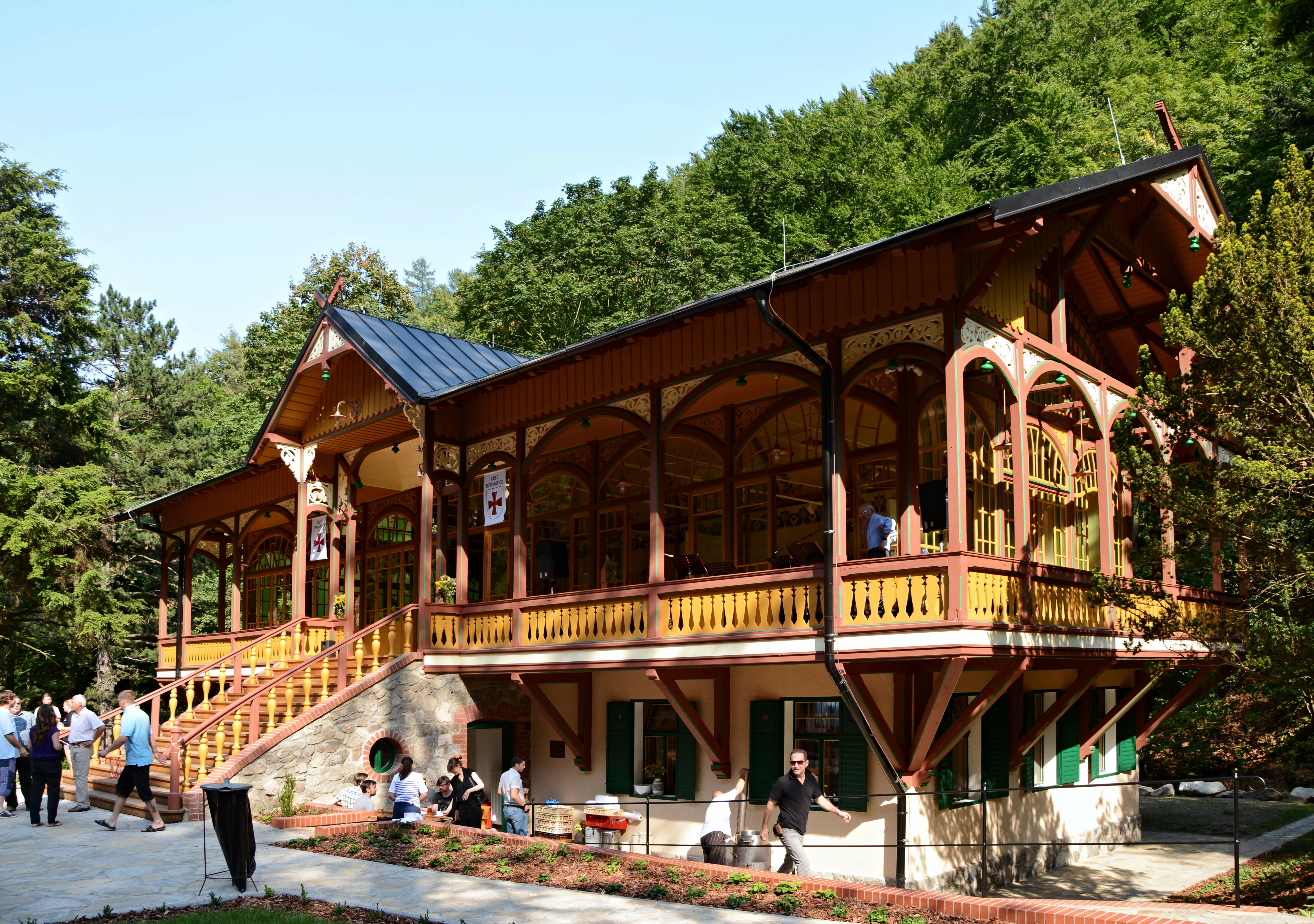
A restored wooden ballroom building with ornate timber framing and a stone foundation, set against a forest backdrop with several visitors walking on the plaza in front.
The historic Tančírna ballroom in Račí údolí, following its restoration.

Račí údolí history and protected-area timeline

Račí údolí had long existed as a forest landscape with scattered cultural sites, but it was not formally protected until the late 20th century. The reserve was officially established on 20 July 1998 by decree of the Okresní úřad Jeseník, the district authority of the time, and is now administered by the Nature Conservation Agency of the Czech Republic. Earlier, portions of the valley had been classified as protective forest, which shielded it from large-scale logging; more accessible parts, however, were clear-cut, leaving behind the higher share of spruce that managers are still working to balance with broadleaf regeneration today.

The valley's cultural history reaches much further back. The 14th-century castle known as Pustý zámek once guarded the approaches to the Rychleby castle higher in the hills; little physical structure survives, but the altered terrain still marks its presence and is freely accessible along the blue-marked hiking route. In the early 20th century, the local industrialist Alois Utner commissioned the Art Nouveau pavilion Tančírna, originally called Georgshalle, in 1907 to host social events in the valley. In 1928, his son, the architect Herbert Utner, built the pension and inn Haus Isolde nearby, named after his youngest daughter, who became a devoted promoter of the site.

Operation of the pension changed hands several times. After the Second World War it was run by Ludvík Fellmayer; after 1948 it was nationalized and managed by Jednota Zábřeh, which organized Pi营造ášské camps and company excursions on the premises. Following the Velvet Revolution the property declined, until Josef Rabensfeiner purchased it in 1997 and re-established pension operations. In 2012 his daughter Martina Rabenseifnerová took over management; organized summer camps ceased in 2021, but the pension remains open and Tančírna continues to host cultural events. The pavilion finally acquired the formal protection it had long deserved as a heritage monument on 1 July 2019. The combination of medieval ruins, an Art Nouveau pavilion, and a 1998 nature reserve gives Račí údolí a notably layered history for such a small site.

Račí údolí landscape and geographic character

Račí údolí is a narrow, wooded valley on the northern edge of the Olomouc Region, southwest of Javorník and a short distance from the Polish border. The reserve sits in the foothills of the Hrubý Jeseník mountains and is part of the larger Krkonoše-Jeseník geomorphological system, which gives the valley its rounded ridges, moderate slopes, and stream-cut floor typical of the eastern Bohemian Massif.

Elevation within the protected area ranges from roughly 348 meters above sea level along the valley floor to about 532 meters at the upper edges, creating a relatively compact vertical profile. The bedrock is composed of metamorphic rocks of the Orlice-Kladsko crystalline complex: two-mica and granulitic gneisses, together with light and pyroxenic granulites. This geology has shaped both the topography and the local soils, producing a rocky, acid-influenced landscape that visibly expresses itself in the viewpoint known as Čertova kazatelna, a gneiss outcrop from which the entire valley unfolds to the southwest against the current of the Račí potok.

Soils across the reserve are mostly acidic. Brown rankers dominate on rocky exposures, forming a mosaic with undeveloped soils on rocky outcrops, while oligotrophic and mesotrophic brown earths occupy more stable slopes. Small pockets of podzol occur locally, reinforcing the acid character of the site. The fourth-order stream Račí potok runs along the valley bottom, draining the catchment into Poland and onward into the Oder basin.

The climate is classified within the Czech Quitt system as the cool CH7 zone, characterized by mild to slightly cool conditions, light winter humidity, more humid summers, a short growing season, and a long autumn transition. Together, the geology, soils, hydrology, and climate combine to produce a forested landscape feel that closely resembles the upland forests of the broader Jeseník region, but with sharper, rockier accents visible from Čertova kazatelna and along the slopes above the stream.
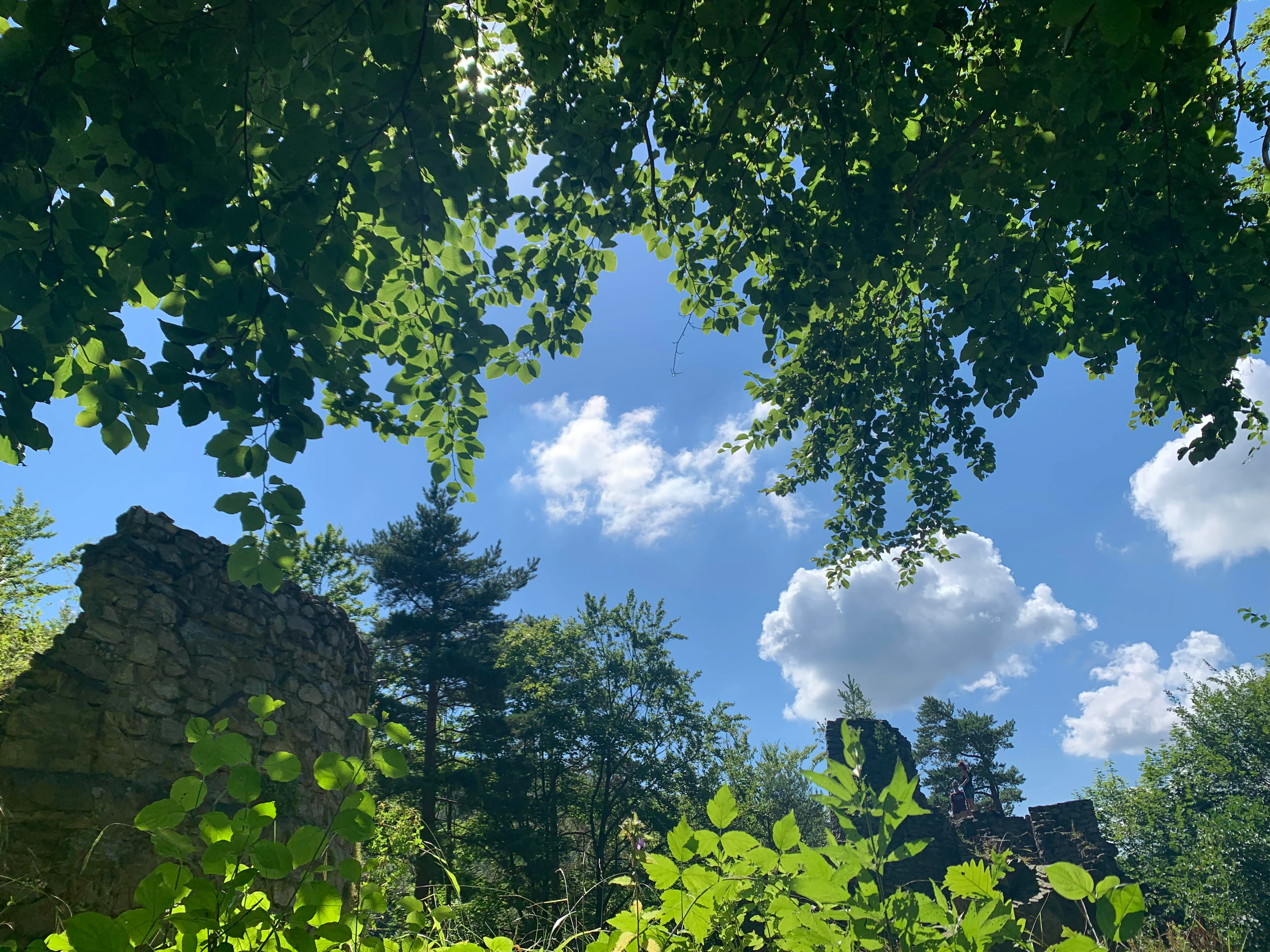
Ancient stone wall ruins of Pustý zámek emerging from a dense forest, framed by lush green leaves against a bright blue sky with white clouds.
Remains of Pustý zámek castle ruins viewed through the dense forest canopy of Račí údolí.

Račí údolí ecosystems, habitats, and plant life

Račí údolí is fundamentally a forest reserve, and its ecological value rests almost entirely on the composition, structure, and developmental stage of its woodlands. The vegetation is dominated by stands that match the natural site conditions of the valley: oak and lime-beech forests on the more stable, base-richer soils, complemented by fresh and moist beech communities on cooler and damper slopes. These represent the reference communities that conservation managers aim to maintain or restore across the reserve.

Interspersed with these natural communities are coniferous patches whose composition reflects the area's forestry past. The more accessible slopes were historically clear-cut, and the resulting regeneration is heavily skewed toward spruce, which today forms the single most abundant conifer in the reserve. Broadleaf representation, by contrast, is led by beech, with oak, linden, fir, pine, and some maple contributing less common but ecologically important elements. Because young broadleaves are vulnerable to browsing by deer, conservation strategy explicitly relies on natural regeneration being allowed to proceed without artificial boosting of game populations.

Soils reinforce this ecological character. The acidic brown rankers and brown earths, with localized podzols, sit on a metamorphic gneiss and granulite substrate, producing conditions well suited to the oak-lime-beech community and to acid-tolerant conifers such as spruce and pine. The hydrology adds another dimension: the steady flow of the Račí potok supports both riparian microhabitats along the valley floor and, following the reintroduction of crayfish in cooperation with the Czech Ministry of the Environment, a small but notable aquatic component. Together, these elements create a compact but ecologically layered site where forest, geology, soil chemistry, and freshwater intersect.

The ecological profile is also reinforced by the reserve's overlap with the European Site of Community Importance known as Rychlebské hory – Račí údolí. This designation underlines the international recognition of the area's habitat value and ties local management into a wider Natura 2000 framework for protecting the broader foothill forests of the eastern Jeseník region.

Račí údolí wildlife and species highlights

Wildlife in Račí údolí reflects the broader Central European forest fauna typical of upland broadleaf and mixed woodland. The reserve's size is modest, so most species present are characteristic forest generalists rather than large-mammal specialists. Common forest mammals, small carnivores, and typical woodland bird communities are all expected within the protected area, although detailed inventories are still being developed for some groups.

A handful of specially protected species anchor the reserve's faunal significance. The black stork (Ciconia nigra) breeds in secluded, mature-forest conditions and benefits from the reserve's quiet, lightly managed valleys. The goshawk (Accipiter gentilis) similarly depends on older woodland structure for nesting and hunting. Along the Račí potok, the Eurasian otter (Lutra lutra) uses the stream and its surroundings, an indication of relatively healthy freshwater habitat. The common toad (Bufo bufo) occurs in the damp forest understory and along the stream corridor.

Bats are an important management consideration even though specific species are not individually highlighted in available sources. Because older stands are deliberately left to develop without intervention, they continue to provide roosting opportunities in hollows, cracks, and loose bark. The reserve management plan explicitly favors this passive approach to support bat populations.

Aquatic life has been actively enriched. In cooperation with the Czech Ministry of the Environment, more than a hundred crayfish were restocked into the Račí potok, reintroducing a native freshwater group that had disappeared from the local system and adding a focal species for the valley's stream habitat.

Overall, the wildlife profile of Račí údolí is shaped less by charismatic rare species than by the integrity of the forest and stream habitats themselves. Protection of older trees, retention of dead and decaying wood, restriction of game management that would damage young broadleaves, and careful recreational use all combine to maintain the conditions that Central European forest wildlife depends on.

Račí údolí conservation status and protection priorities

Conservation management in Račí údolí rests on a quiet, hands-off philosophy. The reserve was established in 1998 with the explicit goal of preserving forest stands of near-natural character, and managers today continue to prioritize natural processes over active reshaping of the forest. Older stands are left to develop on their own, which simultaneously maintains the vertical layering typical of untouched woodland and provides roosting habitat for bats and other cavity-dependent species.

Management also aims to correct the legacy of past forestry. Because more accessible parts of the valley were once clear-cut, spruce became overrepresented in many stands. The current strategy combines reliance on natural regeneration with limited replanting of native and historically underrepresented species, gradually replacing artificial spruce-dominated communities with the oak-lime-beech forest that better fits the site's soils and elevation. Hunting activities within the reserve, administered under the Janský vrch hunting district, are oriented toward protecting young broadleaves rather than maximizing game density, which is why supplementary feeding stations and salt licks are deliberately avoided.

The reserve's legal and international framework reinforces its conservation role. As a Category IV protected area under IUCN criteria, it is recognized primarily for habitat and species management. The valley also overlaps with the European Site of Community Importance Rychlebské hory – Račí údolí, placing it within the Natura 2000 network and aligning its conservation objectives with broader European biodiversity targets for foothill forests of the eastern Jeseníky.

The freshwater dimension adds a smaller but distinctive conservation strand. The reintroduction of crayfish into the Račí potok, carried out jointly by the local pension and the Ministry of the Environment, represents an effort to restore a lost native component of the stream ecosystem. Proposed future measures include guardrails along the most exposed sections of the path to Čertova kazatelna to limit trampling, as well as systematic inventories of plants, fungi, and birds, which would strengthen the scientific basis for future management. Together, these strands highlight Račí údolí as a small but well-integrated conservation site where forest, habitat, freshwater, and visitor management converge.

Račí údolí cultural meaning and human context

The cultural dimension of Račí údolí is unusually rich for such a small natural site. The valley carries traces of medieval fortification, 19th-century industrial leisure culture, and 20th-century political and social history, layered on top of an older landscape of forest pathways and lookout points.

The most ancient surviving feature is the ruin known as Pustý zámek, a 14th-century fortress that once served as an observation point overlooking the more powerful Rychleby castle higher in the hills. Little is known about its builder, though the scale of construction suggests involvement of a bishop or a powerful local lord; today only terrain fragments remain, openly accessible along the blue-marked tourist trail.

At the opposite end of the cultural timeline stands the Tančírna pavilion, a striking Art Nouveau hall completed in 1907 by Alois Utner and originally called Georgshalle. Intended as a venue for social events, it was expanded in 1928 by Utner's son, the architect Herbert Utner, with the pension named Haus Isolde after his youngest daughter, who became one of the valley's most devoted patrons. Subsequent decades brought nationalization, use as a Pi营造ášský summer camp and worker retreat under the post-1948 regime, decline after the Velvet Revolution, and gradual revival through private ownership after 1997. The pavilion's formal recognition as a heritage monument on 1 July 2019 confirmed its lasting cultural significance and cemented its place within the broader identity of the valley.

Between these two poles lies the natural lookout of Čertova kazatelna, a gneiss rock formation whose evocative name and broad view have long made it a focal point for visitors exploring the valley on foot. Together, these layers give Račí údolí a cultural identity that is not simply attached to the landscape but is genuinely interwoven with it.

Top sights and standout views in Račí údolí

Račí údolí stands out as a compact reserve where forest ecology and human heritage occupy the same small valley. Its old-growth oak, linden, and beech woodlands contrast with spruce-dominated stands from earlier forestry cycles, creating a textbook example of natural regeneration in action within the broader Jeseník foothills.

Equally distinctive is the cultural layering. The ruins of 14th-century Pustý zámek, the Art Nouveau Tančírna pavilion, and the natural viewpoint at Čertova kazatelna combine to give visitors a sequence of historical and scenic encounters within a single short walk. The reserve's overlap with the European Site of Community Importance Rychlebské hory – Račí údolí, combined with its crayfish reintroduction initiative, adds further reasons why this small foothill valley attracts attention beyond the local region.

Best time to visit Račí údolí

The cool CH7 climate of Račí údolí shapes a valley where summers are short and mild, autumns long, and winters moist but not extreme, with brief periods of frost and occasional snow. Spring brings fresh green expansion of the broadleaf canopy, brighter light in the forest understory, and higher stream flows along the Račí potok, all of which tend to make the valley feel especially alive.

Late spring through early autumn is generally the most comfortable period for visiting. Forests are fully leafed, paths to Čertova kazatelna and Pustý zámek are most easily walked, and the Tančírna pavilion is more likely to host cultural events and stay open as part of the pension operations. Autumn extends the season with rich foliage colors over the beech and oak stands. Winter visits are possible but bring shorter daylight, wet or snowy conditions on the steeper paths, and reduced availability of services at the pension, though the cold-season atmosphere of the gneiss rocks and bare deciduous canopy has its own appeal.


Monthly climate preview

Review measured monthly temperature swings and precipitation patterns across the representative park coordinate

Račí údolí Climate and Long Term Weather by Month Normals

Representative coordinates record distinct annual temperature shifts alongside steady precipitation distribution across twelve measured months. Examining complete monthly climate normals reveals deeper baseline records for temperature and precipitation.
Annual mean8 °C
-3 °C19 °C
Jan-3°
Feb-2°
Mar
Apr
May12°
Jun16°
Jul19°
Aug18°
Sep13°
Oct
Nov
Dec-2°
Warmest month
July

18.6 °C

Coolest month
January

-3.4 °C

Wettest month
July

3.1 mm/day

Driest month
February

1.5 mm/day

Park location guide

Geography guide, regional context, and park location map for Račí údolí

Račí údolí park geography, regions, and map view in Czechia

Understand where Račí údolí sits in Czechia through a broader geographic reading of the surrounding landscape, nearby location context, and its mapped position within the national park landscape.

How Račí údolí fits into Czechia

Czech Republic is a landlocked Central European country with a population of approximately 10.9 million people. The nation was established as an independent state on January 1, 1993, following the dissolution of Czechoslovakia. Its capital and largest city is Prague, with other major urban centers including Brno, Ostrava, Plzeň, and Liberec.

Wider geography shaping Račí údolí in Czechia

The Czech Republic is a landlocked country in Central Europe. It is bordered by Germany to the west, Austria to the south, Poland to the northeast, and Slovakia to the southeast. The landscape is predominantly hilly, with the territory covering 78,871 square kilometers.

Map view of Račí údolí

Use this park location map to pinpoint Račí údolí in Czechia, understand its exact geographic position, and read its mapped placement within the surrounding landscape more clearly.

Pigeon | © OpenStreetMap contributors

Location context for Račí údolí

Olomouc Region

Explore the terrain, old-growth deciduous woodlands, and geological formations of the reserve.

Račí údolí Photos and Landscape Scenery: Visualizing the Protected Forest Valley

Photographic records reveal the closed-canopy oak-lime-beech woodlands and rocky gneiss outcrops defining the valley floor. Visual exploration provides direct insight into the protected habitats, stream-cut topography, and natural environment of the Jeseník foothills.

A restored wooden ballroom building with ornate timber framing and a stone foundation, set against a forest backdrop with several visitors walking on the plaza in front.

A wide, eye-level outdoor shot of a forested valley during autumn, with colorful foliage and coniferous trees visible under a clear blue sky.

Ancient stone wall ruins of Pustý zámek emerging from a dense forest, framed by lush green leaves against a bright blue sky with white clouds.

Park atlas

Compare adjacent forest reserves and mountain terrain across the northern Jeseník foothills.

Exploring Parks Near Račí Údolí And Surrounding Protected Regional Landscapes

Continue geographic discovery beyond Račí údolí by browsing other protected natural areas and wooded valleys located throughout the surrounding mountain foothills. Comparing adjacent regional reserves helps reveal broader forest conservation patterns and terrain variations across the eastern Bohemian Massif.
Protected landscapeDolnośląskie
About 4.7 km away#1 closest

Southwest

Śnieżnicki Park Krajobrazowy: Protected Landscape and Mountain Geography Atlas

Eastern Sudetes protected area in Dolnoslaskie, Poland

Located in the Dolnoslaskie region, Śnieżnicki Park Krajobrazowy protects a striking mosaic of primeval forest and varied mountain relief. This entry maps its core components, from the high peak of Śnieżnik to the intricate karst landforms and deep river valleys that define its regional geographic character.

Area
288 km²
Established
1981
Relief
Mountain
Climate
Alpine
Natural monumentOlomouc Region
About 11 km away#2 closest

South

Vodopády Stříbrného potoka: Natural Monument and Mountain Stream Geography in Olomouc Region

Geomorphological landmark within the Rychlebské hory mountain range

Vodopády Stříbrného potoka is a protected natural monument in the Czech Republic, encompassing a narrow, steep-sided valley defined by bedrock cascades. This compact site highlights mountain stream geomorphology and serves as a significant feature in the Rychlebské hory, offering insight into the distinctive eroded terrain of the Jeseník District.

Area
0.017 km²
Established
1965
IUCN
III
Relief
Mountain
Protected areaOpole Voivodeship
About 24 km away#3 closest

East

Przyłęk nad Białą Głuchołaską: Protected Area and River Landscape Geography in Poland

Mapped riparian habitats within Opole Voivodeship

Focusing on the Biała Głuchołaska river valley, this area preserves a complex system of active river channels, gravel bars, and terrace forests. The landscape transitions from wet willow-poplar galleries to stable oak-hornbeam communities. As a Natura 2000 site in the Opole Voivodeship, the terrain provides a clear look at submontane river processes interacting with lowland forest habitats.

Area
3.193 km²
Relief
Lowland
Climate
Temperate
Scope
Terrestrial
Protected areaLower Silesian Voivodeship
About 27 km away#4 closest

North

Wzgórza Strzelińskie Protected Area: Geographic Atlas and Regional Landscape Mapping

A diverse Natura 2000 hill landscape in southwestern Poland.

Spanning over 3,800 hectares, Wzgórza Strzelińskie functions as a vital refuge for specialized European habitats. The area features a complex intersection of beech-dominated forests, rocky cliff communities, and traditional meadows that define the local Silesian topography. This record provides a detailed look at the park boundaries, ecosystem distribution, and the natural terrain that shapes this conservation site.

Area
38.362 km²
Relief
Upland
Water
Minor water
Natural monumentOlomouc Region
About 39 km away#5 closest

South

Sobotín, domov důchodců Protected Natural Monument in the Czech Republic

A specialized Olomouc Region conservation site and habitat refuge

Examine the geographic and ecological boundaries of Sobotín, domov důchodců, a protected natural monument situated in the Olomouc Region. Learn how this site provides essential environmental stability within its broader regional setting, serving as a critical example of small scale habitat conservation in northern Moravia.

Area
0.001 km²
Established
2013
IUCN
III
Relief
Lowland
A horizontal watercolor illustration depicting a prominent weathered sandstone rock formation surrounded by forest, set against a soft, light-filled sky.
National parkDolnośląskie
About 40 km away#6 closest

West

Park Narodowy Gór Stołowych: A Geologic Atlas of Table Mountains in Lower Silesia

Mapping sandstone labyrinths and protected forest plateaus in the Sudetes

Explore the definitive map and geographic profile of Park Narodowy Gór Stołowych, a protected area characterized by its horizontal sandstone layers and dramatic rock towers. This atlas entry provides insight into the park's sedimentary landscape, covering iconic summit plateaus, dense forest environments, and the contrasting igneous geology of the surrounding terrain.

Area
63.402 km²
Established
1993
Visitors
1.3M annual
Relief
Mountain
Watercolor artwork depicting a landscape with green hills, distant mountains, and pastel sky
National parkLower Silesian Voivodeship
About 40 km away#7 closest

West

Stołowe Mountains National Park: Explore Poland's Sandstone Rock Cities and Protected Terrain

National Park in Lower Silesian Voivodeship: Geological Wonders.

Stołowe Mountains National Park is a protected national park in Poland celebrated for its unparalleled sandstone geological features. Within the Lower Silesian Voivodeship, the park showcases a dramatic landscape dominated by flat-topped rock plateaus, natural labyrinths, and vertical sandstone formations that create a visually stunning and geologically significant environment. Its protected status ensures the preservation of these unique landforms and the rare ecosystems, such as raised peat bogs, offering extensive opportunities for atlas exploration and understanding the region's distinct natural context.

Area
63.39 km²
Established
1993
IUCN
II
Visitors
1.3M annual
Natural monumentKrálovéhradecký kraj
About 41 km away#8 closest

West

Velká louka Natural Monument: Geographic Profile of an Orlické hory Wetland Habitat

Protected peat meadow terrain in the Královéhradecký kraj region.

Velká louka represents a focused protected landscape in the Czech Republic, known for its rare botanical composition and wetland-dependent amphibian pools. The site highlights the importance of small-scale conservation efforts within the mountainous Orlické hory region, offering a clear example of specialized meadow ecology in a submontane climate.

Area
0.023 km²
Established
1982
IUCN
IV
Relief
Upland

Common questions about visiting, size, designation, and location context for Račí údolí

Račí údolí FAQs for park facts, access, geography, and protected area context

Find quick answers about Račí údolí, including protected-area facts, park geography, trail and visitor context, and how the park fits into its surrounding country and regional landscape.
MoriAtlas Explorer

Continue Your Protected Areas Search Across the Global Atlas

Deepen your exploration by continuing the structured search for national parks and protected areas worldwide. Utilize the comprehensive filtering capabilities to compare different conservation landscapes and refine your understanding of global park geography. Discover more about the distribution and characteristics of protected natural areas.

Global natural geography