

Mori Atlas logo
Nature reserveReserva ecológica Arenillas

Tracing the dry forest landscapes and protected boundaries within this significant ecological territory

Reserva ecológica Arenillas: A Comprehensive Map and Geographic Portrait of a Vital Nature Reserve

(Reserva Ecológica Arenillas)

Reserva ecológica Arenillas represents a primary protected landscape, safeguarding significant remnants of dry forest and coastal ecosystems. This geographic profile details the reserve's specific terrain, from inland deciduous forest patches to coastal mangrove zones. Through a focus on mapped boundaries and regional ecological context, gain a clearer understanding of how this nature reserve functions as a critical refuge for wildlife and habitat preservation within the wider Pacific coastal geography.

dry forestTumbesian ecoregionmangroveendemic birdsprotected areamilitary reserve

Reserva ecológica Arenillas

Nature reserve

Park overview

Structured park overview, official facts, and landscape profile for Arenillas Ecological Reserve

Arenillas Ecological Reserve park facts, protected area profile, and essential visitor context

Review the core facts for Arenillas Ecological Reserve, including designation, size, terrain, visitor scale, habitats, and operating context in one park-focused overview.

About Arenillas Ecological Reserve

The Arenillas Ecological Reserve (REA) is a sizable protected area in southwestern Ecuador, established to conserve one of the last major blocks of dry tropical forest and shrubland in the country's coastal lowlands. Spanning more than thirteen thousand hectares in El Oro Province, between the cantons of Arenillas and Huaquillas, it lies in a strategic position near Ecuador's southern border and within the Tumbes-Piura dry forest ecoregion, one of the most threatened forest types on the Pacific coast of South America.

The landscape of the reserve ranges from sea level to roughly three hundred meters elevation and combines inland deciduous woodland and thorny shrub formations with coastal mangrove systems. This mosaic supports an unusually high concentration of endemic and range-restricted species for such a small geographic area. The dry forest here is characterized by species adapted to prolonged dry seasons, including thorny legumes, cacti, and deciduous canopy trees, while the mangroves along the coast provide habitat for resident and migratory birds, crustaceans, and fish.

Arenillas is recognized internationally as an Important Bird and Biodiversity Area because it supports a significant proportion of the endemic avifauna of the Tumbesian region. Threatened species such as the grey-cheeked parakeet, the slate-colored becard, and the blackish-headed spinetail all depend on the reserve's dry forest. Beyond its bird importance, the area also harbors notable mammal, reptile, amphibian, and plant endemics, making it a critical refuge for overall Neotropical dry-forest biodiversity.

Although the reserve was first set aside as a protected area more than six decades ago, it was not formally incorporated into Ecuador's National System of Protected Areas until 2001. Its administration by the Ministry of Defense, due to its overlap with a military reserve, has meant that public access is restricted and habitat disturbance has historically been limited, contributing to the relatively intact state of its ecosystems today.

Quick facts and research context for Arenillas Ecological Reserve

Arenillas Ecological Reserve is located in El Oro Province in southwestern Ecuador, close to the Peruvian border, and spans parts of Arenillas and Huaquillas cantons. It covers roughly thirteen thousand hectares of lowland terrain, from sea level up to about three hundred meters in elevation, and is classified as a strict nature reserve under IUCN Category Ia.

The reserve belongs to Ecuador's National System of Protected Areas and is administered by the Ministry of Defense because of its overlap with a military zone. Its habitats are dominated by Tumbes-Piura dry forest, tropical dry shrubland, and mangrove, and it is recognized internationally as an Important Bird Area for its Tumbesian endemics.

Protection and recognition

Examine the documented protection status and conservation scope for Reserva ecológica Arenillas.

Reserva ecológica Arenillas Protection Status and Recognition

Comprehensive protected area records detail the mixed management scope and international recognition status established for Reserva ecológica Arenillas. Structured preservation data provides clear insight into official conservation frameworks governing this regional landscape.

Protection details

Protection scope
Mixed
Transboundary protection
No
Park context

Deeper park guide and search-rich context for Arenillas Ecological Reserve

Arenillas Ecological Reserve history, landscape, wildlife, and travel context

Explore Arenillas Ecological Reserve through its history, landscape character, ecosystems, wildlife, conservation priorities, cultural context, and seasonal travel timing in a structured park guide built for atlas discovery and search intent.

Why Arenillas Ecological Reserve stands out

Arenillas is best known as one of Ecuador's largest and most intact remnants of Tumbes-Piura dry forest, a naturally dry and deciduous ecosystem that is increasingly rare and fragmented along the Pacific coast. The reserve is a stronghold for endemic birds of the Tumbesian region, including globally threatened species such as the grey-cheeked parakeet. The reserve is also distinguished by the combination of its dry forest interior with coastal mangroves, creating a transition between terrestrial dry habitats and tidally influenced shoreline that supports both resident and migratory species. Its dual role as an ecological reserve and a military-restricted area has helped keep large portions of the habitat in unusually good condition for this part of Ecuador.

Arenillas Ecological Reserve history and protected-area timeline

The area now known as Arenillas Ecological Reserve was originally declared as a protected area more than sixty years before its modern designation, reflecting an early recognition of the ecological value of Ecuador's southwestern dry forests. A foundational interministerial agreement in 1994 (Acuerdo Interministerial N.º 1646) initiated the formal steps toward recognizing the area's conservation significance.

The reserve's modern identity dates to 2001, when it was officially incorporated into Ecuador's National System of Protected Areas through Registro Oficial N.º 342 of June 7, 2001. A subsequent modification, recorded in Registro Oficial N.º 787 of September 12, 2012, refined its official status. Throughout this period, the Federal Foundation for Environmental Research and Management (FEDIMA) played a central role in producing the technical studies that justified the area's transition from a military reserve to a formally recognized Ecological Reserve.

The reserve's overlap with a military zone continues to shape its administration and access policies. Visitors must request permission to enter, and management responsibility rests with Ecuador's Ministry of Defense rather than its environmental ministry. In parallel, nongovernmental organizations such as Fundación Cerro Verde have worked with local communities in the buffer zone to build a local management committee representing thirty-six communities, supporting conservation through environmental education initiatives.

Arenillas Ecological Reserve landscape and geographic character

The Arenillas Ecological Reserve occupies lowland terrain in the Pacific coastal region of southwestern Ecuador, with elevations ranging from sea level to around three hundred meters above sea level. This relatively gentle topography creates a setting where vegetation transitions smoothly from inland dry formations to coastal systems, allowing distinct habitat zones to develop close together.

The interior of the reserve is dominated by lowland deciduous forest and tropical dry shrubland typical of the Tumbes-Piura ecoregion. Trees here tend to be relatively short and adapted to long dry seasons, with thorny legumes, cacti, and bromeliads contributing to a distinctive dry-forest structure. Although the original stands of commercially valuable timber have largely been removed, the broader vegetation patterns have persisted, and the habitats are described as being in good overall condition.

As the terrain nears the coast, vegetation becomes shorter and more shrubby, eventually giving way to mangrove systems that extend along roughly twenty-eight hundred hectares of shoreline. The mean annual temperature is around twenty-four degrees Celsius, consistent with the warm, semi-arid conditions that define this stretch of the Ecuadorian coast. Together, these characteristics give the reserve a landscape profile quite distinct from the wetter cloud forests and Andean ecosystems more commonly associated with Ecuador.

Arenillas Ecological Reserve ecosystems, habitats, and plant life

Ecologically, Arenillas represents one of the most significant surviving blocks of tropical dry forest in Ecuador, a habitat type that has been heavily reduced across the Tumbes-Piura region. The reserve's vegetation combines deciduous lowland forest, dry thorny shrubland, mangrove, and successional growth, creating a patchwork of habitats that supports both forest-interior species and coastal-edge fauna.

Approximately one hundred and eleven plant species have been documented within the reserve, distributed across around fifty families. Of these, seventy-six are native and twenty-five are endemic to the Tumbesian region, while ten are introduced. The Mimosaceae family stands out for its species richness, with nine recorded species, followed by cacti and bromeliads as notable components of the dry plant community.

Juvenile populations of important forest species such as Tabebuia chrysantha, Ziziphus thysiflora, and Albizia guachapele are recovering in the reserve, along with mature individuals of large trees like Ceiba trischistandra and Ficus species. The mangroves along the coast contribute additional plant diversity and play a particularly important role in supporting marine and bird life. The combination of these habitats gives the reserve a particularly high ecological value for its size.

Arenillas Ecological Reserve wildlife and species highlights

Wildlife at Arenillas reflects the broader importance of the Tumbes-Piura ecoregion as a center of endemism on the Pacific coast. Around one hundred and fifty-nine animal species have been recorded in total across multiple classes, with birds making up the most species-rich and conservation-significant group.

The reserve hosts roughly one hundred and fifty-three bird species, of which approximately thirty-five percent are endemic to the Tumbesian region. It supports globally threatened species such as the grey-cheeked parakeet (Brotogeris pyrrhoptera), the slate-colored becard (Pachyramphus spodiurus), and the blackish-headed spinetail (Synallaxis tithys). The mangrove areas serve as important gathering sites for both resident and migratory congregatory bird species, contributing to seasonal diversity.

Twenty-six mammal species have been documented across fifteen families, including the Sechuran fox, the lesser anteater, the nine-banded armadillo, the jaguarundi, the tayra, and the crab-eating raccoon. A high number of these mammals, fifteen of the twenty-six recorded, fall within some category of conservation concern, highlighting the regional pressures on dry-forest mammal populations. Reptile and amphibian registrations together involve around nineteen species, including several Tumbesian endemics such as the Arenillas lizard (Callopistes flavipunctatus) and the Tumbes toad (Ceratophrys stolzmanni).

Arenillas Ecological Reserve conservation status and protection priorities

Arenillas Ecological Reserve is a cornerstone of dry-forest conservation in southwestern Ecuador, where natural vegetation has been heavily transformed by agriculture, timber extraction, and coastal development. By protecting more than thirteen thousand hectares of Tumbes-Piura dry forest, dry shrubland, and mangrove, the reserve maintains ecological processes and habitat connectivity that would otherwise have been lost in this region.

The reserve receives particular conservation attention because of its high concentration of endemic species. Roughly a third of its recorded bird species are endemic to the Tumbesian region, and a significant proportion of its mammals, reptiles, amphibians, and plants are similarly restricted in range or considered threatened. Its designation as an Important Bird and Biodiversity Area by BirdLife International reflects this global significance.

Its inclusion in Ecuador's National System of Protected Areas gives the reserve a formal conservation framework, while its administration as a military zone has, in practice, also contributed to the preservation of its habitats by limiting public access and large-scale human pressure. Conservation efforts extend beyond the reserve boundaries through the work of organizations such as Fundación Cerro Verde, which supports a local management committee of thirty-six communities in the buffer zone and runs environmental education activities grounded in field ecology.

Arenillas Ecological Reserve cultural meaning and human context

The reserve is situated within El Oro Province in a region shaped by Ecuadorian coastal livelihoods, including agriculture, ranching, and cross-border commerce with neighboring Peru. The cantons of Arenillas and Huaquillas, in which the reserve lies, have long-standing local communities that interact with the surrounding landscape in traditional ways, including dry-forest land use and coastal resource harvesting.

In the buffer zone, organizations working around the reserve have helped organize thirty-six local communities into a participatory management committee, linking conservation action with regional social structure. This kind of community-based environmental governance is part of the broader cultural context in which the reserve operates, integrating conservation planning with local identity and stewardship traditions of the southwestern Ecuadorian coast.

Top sights and standout views in Arenillas Ecological Reserve

Arenillas stands out for protecting one of the largest remaining blocks of Tumbes-Piura dry forest on the Ecuadorian coast, a habitat type that is disappearing quickly elsewhere in the region. Its dry-forest interior and coastal mangroves together support a remarkable concentration of endemic Tumbesian species, especially birds, mammals, and reptiles.

The reserve also stands out for its unusual administrative context: although it is part of Ecuador's national system of protected areas, it is managed by the Ministry of Defense because of its overlap with a military zone. This combination of legal protection and restricted access has helped keep habitats in unusually good condition, making the reserve an important benchmark for understanding intact dry-forest ecosystems of the Pacific coast.

Best time to visit Arenillas Ecological Reserve

Because Arenillas lies in a coastal dry-forest region with a relatively stable warm climate averaging around twenty-four degrees Celsius, the experience of visiting the reserve shifts mainly with the wet and dry seasons that characterize the Tumbes-Piura ecoregion. The dry season typically offers clearer skies, easier trail access, and more concentrated wildlife viewing around water sources, while the wet season brings lusher vegetation and heightened bird activity, particularly among migrant and breeding species.

Visitors should also keep in mind that the reserve is administered as a military zone, and access requires advance permission from the relevant authorities. Planning around this requirement, rather than around weather alone, is often the most important step for a successful and responsible visit.

Monthly climate preview

Long-term representative point measurements of monthly temperature and precipitation patterns

Reserva ecológica Arenillas Climate Normals and Annual Temperature Rhythm

Reserva ecológica Arenillas maintains consistent mean annual temperatures alongside distinct shifts in monthly precipitation across the sampled coordinate. Examining the complete twelve-month record reveals detailed variations in average minimum and maximum temperatures throughout the year.
Annual mean24 °C
23 °C24 °C
Jan24°
Feb24°
Mar24°
Apr24°
May24°
Jun24°
Jul23°
Aug24°
Sep24°
Oct23°
Nov23°
Dec24°
Warmest month
May

24.1 °C

Coolest month
November

23.3 °C

Wettest month
March

4.7 mm/day

Driest month
August

0.3 mm/day

Park location guide

Geography guide, regional context, and park location map for Arenillas Ecological Reserve

Arenillas Ecological Reserve park geography, regions, and map view in Morocco

Understand where Arenillas Ecological Reserve sits in Morocco through a broader geographic reading of the surrounding landscape, nearby location context, and its mapped position within the national park landscape.

How Arenillas Ecological Reserve fits into Morocco

Morocco is a North African country bordering the Mediterranean Sea to the north and Atlantic Ocean to the west. It borders Algeria to the east and the disputed Western Sahara territory to the south. The country operates as a parliamentary constitutional monarchy under King Mohammed VI, with Arabic and Tamazight as official languages. Morocco has a population of approximately 37 million and covers an area of about 446,550 km².

Wider geography shaping Arenillas Ecological Reserve in Morocco

Morocco occupies the northwestern corner of Africa, bordering the Mediterranean Sea to the north and Atlantic Ocean to the west. The country shares borders with Algeria to the east and the disputed Western Sahara territory to the south. The terrain is diverse, featuring the Atlas Mountains in the central and southern regions, Rif Mountains in the north, and plains along the coastal areas. The country also claims Spanish exclaves of Ceuta and Melilla.

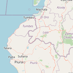
Map view of Arenillas Ecological Reserve

Use this park location map to pinpoint Arenillas Ecological Reserve in Morocco, understand its exact geographic position, and read its mapped placement within the surrounding landscape more clearly.

Pigeon | © OpenStreetMap contributors

Location context for Arenillas Ecological Reserve

Western Sahara
Recorded earthquake history

Examine Recorded Earthquake History Near Reserva ecológica Arenillas

Explore the comprehensive catalogue of recorded seismic events identified within the vicinity of the reserve. This MoriAtlas dataset allows for the review of historical earthquake data, including magnitudes and proximity, to better understand the regional geographic context of the Tumbes-Piura dry forest landscape.

Reserva ecológica Arenillas Earthquake History

Catalogued events

61 events

Strongest magnitude

Magnitude 5.6

Most recent event

Aug 27, 2026

This history includes earthquakes recorded inside the park or within 50 km of its borders

Park atlas

Compare surrounding regional dry forests and coastal protected landscapes

Explore Protected Areas and Parks Near Reserva ecológica Arenillas

Continue browsing national parks and protected areas near Reserva ecológica Arenillas to examine related Tumbesian dry-forest habitats and coastal mangrove zones. Evaluating adjacent regional geography helps reveal broader ecological patterns across the southwestern corner of Ecuador.
National parkPeru
7.6 km away#1 closest

Southwest

Cerros de Amotape National Park: Peru's Protected Pacific Tropical Forest Atlas

Explore mapped boundaries and diverse terrain of this unique landscape.

Cerros de Amotape National Park stands as a significant protected area within Peru, meticulously preserving remnants of the Tumbes-Piura dry forests and Pacific tropical forests. Situated within the Cordillera de los Amotapes, the park features a dynamic landscape from riverine habitats to elevated mountain terrain. This park detail page offers an atlas-style view, focusing on its geographic context, mapped protected boundaries, and its importance as a conservation corridor for unique biodiversity.

Area
1,515.61 km²
Established
1975
IUCN
II
Relief
Mountain
Wildlife reserveGuayas
76 km away#2 closest

North

Refugio de Vida Silvestre Manglares El Morro: Protected Coastal Landscape and Map

A strategic marine and mangrove ecosystem in the Guayas Province

The landscape of Refugio de Vida Silvestre Manglares El Morro consists of continuous mangrove forests and rocky farallones, linked by a complex network of tidal channels. This wildlife refuge serves as an essential marine habitat at the threshold of the Gulf of Guayaquil, showcasing the interplay between tidal aquatic systems and coastal vegetation across the southwestern Ecuadorian region.

Area
101.3 km²
Established
2007
IUCN
Ib
Visitors
23K annual
Wildlife reservePiura Region
81 km away#3 closest

Southwest

El Angolo Game Reserve: Mapped Terrain and Protected Forest Geography in Peru

Seasonally dry tropical forest landscapes in the Piura Region

El Angolo Game Reserve encompasses vast hectares of hilly, dry forest terrain in northwestern Peru. This wildlife reserve is defined by its complex mosaic of trees and seasonal drainages, representing a core component of the regional conservation network. Explore the geographic boundaries and ecological features that characterize this protected area within the northern Peruvian landscape.

Area
650 km²
Established
1975
IUCN
VI
Relief
Upland
A pale, soft watercolor painting showing a stylized, rolling landscape with light green, pink, and yellow hues representing hills and trees.
Nature reserveGuayas Province
92 km away#4 closest

North

Reserva ecológica Manglares Churute: Mapping a Coastal Nature Reserve in Guayas Province

An ecological mosaic of mangrove forests, estuaries, and forested ridges.

Spanning from the inner Gulf of Guayaquil into the Churute hill range, Reserva ecológica Manglares Churute acts as an essential protected area within Ecuador. The region contains one of the country's most significant mangrove complexes, complemented by freshwater lagoons and unique fog-affected forest summits that support diverse wildlife populations and endemic vegetation.

Area
471.74 km²
Established
1979
IUCN
Ia
Relief
Mixed relief
Watercolor painting of a mountain landscape with a lake, rolling hills, and coniferous trees in soft green and yellow tones.
National parkAzuay
97 km away#5 closest

Northeast

Parque nacional Cajas: Mapping the Glacial Lakes and Paramo of the Ecuadorian Andes

Geographic analysis of high-elevation protected lands

Parque nacional Cajas encompasses a rugged, glacial-sculpted plateau characterized by cushion vegetation, boggy wetlands, and frequent fog. This protected area offers deep insight into the highland Andean geography of Azuay, where water bodies and mountain ridges intersect to form an essential ecological and cultural corridor for the region.

Area
293.89 km²
Established
1977
IUCN
II
Visitors
53K annual
National parkEcuador
114 km away#6 closest

Southeast

Podocarpus National Park: Ecuador's Diverse National Park and Protected Landscape

Discover elfin forests, paramo, and over 100 lagoons.

Podocarpus National Park, situated in southeastern Ecuador, stands as a prime example of a protected natural area at a unique biogeographic crossroads. This national park spans dramatic elevational zones, from montane rain forests to high-elevation paramo ecosystems dotted with more than 100 lagoons, offering rich mapped landscape exploration. Its significance lies in the convergence of four distinct ecological systems, contributing to exceptional biodiversity and a rich tapestry of natural terrain.

Area
1,462.8 km²
Established
1982
IUCN
II
Relief
Mountain
National parkEcuador
About 115 km away#7 closest

Northeast

El Cajas National Park National Park: Ecuador's Protected Landscape Geography and Map Context

Explore the mapped protected areas and regional geography of El Cajas National Park.

El Cajas National Park is a protected national park in Ecuador, serving as a focal point for atlas-driven geographic exploration. This page provides detailed insight into the park's mapped boundaries and its significance as a protected natural landscape within Ecuador's broader geography. Understand the context of El Cajas National Park for structured discovery of protected lands and natural terrains across South America.

National parkZamora Chinchipe
128 km away#8 closest

Southeast

Yacurí National Park: Protected Andean Lakes and Volcanic Landscape in Zamora Chinchipe

Discover highland geography and the ancient Inca Trail.

Yacurí National Park is a key protected landscape in Ecuador's southern Andes, celebrated for its remarkable collection of over 46 high-altitude lakes set within dramatic volcanic terrain. Situated in Zamora Chinchipe province, the park preserves a vital stretch of the Inca Trail, complete with archaeological sites. This national park offers a rich exploration of Andean geography, páramo ecosystems, and significant cultural heritage, making it a cornerstone of the region's protected areas.

Area
431 km²
Established
2009
IUCN
II
Relief
Mountain

Common questions about visiting, size, designation, and location context for Arenillas Ecological Reserve

Arenillas Ecological Reserve FAQs for park facts, access, geography, and protected area context

Find quick answers about Arenillas Ecological Reserve, including protected-area facts, park geography, trail and visitor context, and how the park fits into its surrounding country and regional landscape.
MoriAtlas Explorer

Continue Your Protected Areas Search Across the Global Atlas

Deepen your exploration by continuing the structured search for national parks and protected areas worldwide. Utilize the comprehensive filtering capabilities to compare different conservation landscapes and refine your understanding of global park geography. Discover more about the distribution and characteristics of protected natural areas.

Global natural geography


