

Mori Atlas logo
Wildlife reserveEl Angolo Game Reserve

Understanding the terrain, dry forest ecosystems, and regional geography of this unique reserve

El Angolo Game Reserve: Mapped Protected Landscapes in the Piura Region of Northern Peru

(Coto de Caza El Angolo)

El Angolo Game Reserve stands as a significant protected expanse of seasonally dry tropical forest in the Piura Region, encompassing nearly 65,000 hectares of hilly terrain and deep quebradas. This reserve links into a broader regional conservation corridor that includes the Noroeste Biosphere Reserve, bridging the gap between coastal lowlands and the western Andean foothills. Users can analyze the reserve boundaries and its characteristic mosaic of woody vegetation, which provides essential habitat for flora and fauna adapted to one of the most threatened ecosystem types in Peru.

dry forestseasonally dry tropical forestgame reservetrophy huntingwildlife conservationbirdwatching

El Angolo Game Reserve

Wildlife reserve

Park overview

Structured park overview, official facts, and landscape profile for El Angolo Game Reserve

El Angolo Game Reserve park facts, protected area profile, and essential visitor context

Review the core facts for El Angolo Game Reserve, including designation, size, terrain, visitor scale, habitats, and operating context in one park-focused overview.

About El Angolo Game Reserve

El Angolo Game Reserve is one of the principal protected areas of northwestern Peru, covering an expanse of seasonally dry tropical forest in the department of Piura. Its rolling terrain rises from about 200 meters to roughly 1,200 meters above sea level, creating altitudinal variation that supports a diverse dry-forest flora. The reserve sits in a transitional zone between the Pacific coastal plain and the western Andean foothills, where steep quebradas, dry hillsides, and semi-arid valleys combine to shape both the climate and vegetation of the area.

The protected area was formally established on July 1, 1975, and is classified under IUCN category VI, recognizing that sustainable use of natural resources is part of its management mandate. It is administered by SERNANP, the national service of natural areas protected by the Peruvian state. El Angolo's name also appears in its official designation, Coto de Caza El Angolo, which reflects its identity as a regulated game reserve rather than a strictly no-use park.

Beyond its individual borders, El Angolo plays an important role in the wider conservation architecture of northwestern Peru. Together with Cerros de Amotape National Park to the north and Tumbes National Reserve along the coast, it forms the Noroeste Biosphere Reserve, designated by UNESCO in 1977 to safeguard one of the most threatened forest ecosystems in the country. Within this larger framework, El Angolo contributes essential habitat and connectivity for species that depend on intact dry forests for survival.

The climate of the reserve is strongly seasonal, with temperatures ranging from about 15 degrees Celsius in cooler periods to high daytime values approaching 39 degrees Celsius. A defined rainy season runs roughly from December through April, after which the forest becomes more accessible and active. This seasonality shapes both the natural rhythms of the dry forest and the timing of activities within the reserve.

Quick facts and research context for El Angolo Game Reserve

El Angolo Game Reserve covers roughly 65,000 hectares in the Piura region of northern Peru, between 200 and 1,200 meters in elevation. It lies within the seasonally dry tropical forests of the Tumbes-Piura ecoregion, an ecosystem of which only a small fraction is protected in Peru. The reserve was established on July 1, 1975, and is administered by SERNANP, Peru's national service of protected areas.

The reserve is part of the UNESCO-declared Noroeste Biosphere Reserve that also encompasses Cerros de Amotape National Park and Tumbes National Reserve. Its classification allows sustainable use of natural resources, with regulated trophy hunting of white-tailed deer as the principal management activity.

Protection and recognition

Terrestrial conservation metrics established in 1977

El Angolo Game Reserve Protection Status and Designated History

El Angolo Game Reserve maintains a documented terrestrial protection status established in 1977. Official records track management scope and international recognition parameters without supplementary designations.

Protection details

Protection scope
Terrestrial
Designated year
1977
Transboundary protection
No
Park context

Deeper park guide and search-rich context for El Angolo Game Reserve

El Angolo Game Reserve history, landscape, wildlife, and travel context

Explore El Angolo Game Reserve through its history, landscape character, ecosystems, wildlife, conservation priorities, cultural context, and seasonal travel timing in a structured park guide built for atlas discovery and search intent.

Why El Angolo Game Reserve stands out

El Angolo is best known for protecting a significant portion of Peru's seasonally dry tropical forests, one of the country's most endangered ecosystems. The reserve is recognized for its role in conserving tree species such as angolo, algarrobo, ceibo, hualtaco, and palo santo, many of which have become scarce outside protected areas. The reserve is also known as a managed hunting area, where the white-tailed deer is the only legally hunted species under a regulated trophy hunting program. This practical conservation-through-use model, combined with its place within the Noroeste Biosphere Reserve, gives El Angolo a distinctive identity among Peru's protected natural areas.

El Angolo Game Reserve history and protected-area timeline

El Angolo Game Reserve was officially established on July 1, 1975, as a protected area under Peruvian law, with a management orientation that permits controlled use of wildlife resources. Its creation was part of an early wave of protected area designations in Peru aimed at conserving representative samples of the country's natural ecosystems, including the fragile dry forests along the northern coast.

Shortly after its establishment, El Angolo was integrated into a broader regional conservation effort. In 1977, UNESCO recognized the Noroeste Biosphere Reserve, grouping El Angolo with Cerros de Amotape National Park and Tumbes National Reserve to form a coordinated framework for protecting the seasonally dry tropical forests of northwestern Peru. This designation elevated El Angolo's status beyond that of an isolated game reserve and linked it to an internationally recognized biosphere program.

Over time, management of the reserve has continued under the national protected areas authority, SERNANP, with day-to-day hunting oversight shared with the local hunting club of Piura. The reserve's history therefore reflects a balance between regulated recreational use and long-term conservation of a threatened ecosystem.

El Angolo Game Reserve landscape and geographic character

The landscape of El Angolo is shaped by the distinctive terrain of northwestern Peru's dry forest region, where hills, quebradas, and lowland basins combine into a varied terrain over tens of thousands of hectares. Elevations rise from about 200 meters at the lowest points to roughly 1,200 meters along the upper slopes, producing visible transitions between lowland dry forest and mid-elevation hillside vegetation.

The reserve lies in an area where the influence of the Pacific coast and the western Andes meets. Steep, eroded slopes alternate with broader valleys, and seasonal watercourses carve pathways through the forest during the rainy months. Outside that season, the landscape becomes visually drier, with cracked soils, leaf-shedding trees, and open views across the hillsides.

This mosaic of terrain supports the structural diversity of the dry forest itself, from denser tree stands along drainages to more open, sparsely wooded crests. The result is a landscape that feels both expansive and intricately patterned, typical of the Tumbes-Piura seasonally dry tropical forests that El Angolo is known for protecting.

El Angolo Game Reserve ecosystems, habitats, and plant life

El Angolo protects a significant block of the Tumbes-Piura seasonally dry tropical forests, an ecosystem classified as endangered and one of which only a small percentage falls under formal protection in Peru. This type of forest is defined by its pronounced seasonality: a hot, dry period during which many trees lose their leaves, followed by a wetter growing season that revives the canopy and understory. El Angolo's position within this ecosystem gives it a central role in regional dry-forest conservation.

Vegetation in the reserve includes characteristic dry-forest trees such as the angolo, algarrobo, ceibo, frejolillo, overo, hualtaco, almendro, pasallo, palo santo, and local cedro. These species define the vertical and structural character of the forest, ranging from dominant canopy trees to smaller shrubs and understory plants. Many of these trees are emblematic of the Tumbes-Piura region and are increasingly rare in unprotected landscapes.

Because the dry season reduces water availability and the wet season concentrates it into a few months, the reserve's ecology is highly seasonal. Plants, animals, and ecological processes in El Angolo are tightly tuned to this rhythm, making the forest a dynamic system that changes visibly throughout the year.

El Angolo Game Reserve wildlife and species highlights

The wildlife of El Angolo is closely tied to the dry forest ecosystem it protects, with species adapted to seasonal scarcity of water and dense cover. The white-tailed deer is the reserve's signature mammal and the only species legally managed as game within the protected area. Its presence has shaped both the cultural history of the reserve and its current management model.

Beyond the deer, the reserve supports a community of mammals characteristic of northwestern Peru's dry forests. Cougars, jaguuar (often recorded as jaguar), puma-like felids, the northern tamandua, the Guayaquil squirrel, and the Sechuran fox are among the mammal species reported in or near the reserve. These animals depend on intact forest cover and the seasonal productivity of the dry forest for hunting, denning, and movement.

Birdlife is particularly diverse in El Angolo thanks to its position at the intersection of coastal and Andean influences. Species reported in the area include the Andean tinamou, the pale-browed tinamou, the Pacific pygmy owl, the king vulture, the Tumbes sparrow, the red-masked parakeet, the Andean condor, the great egret, the cocoi heron, the ochre-bellied dove, and the long-billed starthroat. The presence of both lowland and highland species contributes to the reserve's importance for birdwatching and regional avian conservation.

Together, this mix of mammals and birds reflects the dry forest's capacity to support a wide array of wildlife within a relatively constrained set of habitat types, underscoring the ecological value of the reserve.

El Angolo Game Reserve conservation status and protection priorities

El Angolo plays a key role in conserving one of the most threatened forest ecosystems in Peru: the seasonally dry tropical forests of the Tumbes-Piura region, of which only about five percent is under formal protection nationally. By safeguarding a large continuous block of this habitat, the reserve helps maintain ecological processes and genetic connectivity that are otherwise rapidly lost to agriculture, grazing, and land conversion in surrounding areas.

Its inclusion in the UNESCO-declared Noroeste Biosphere Reserve in 1977, alongside Cerros de Amotape National Park and Tumbes National Reserve, has positioned El Angolo within a coordinated regional conservation framework. This biosphere designation emphasizes the importance of maintaining dry forest linkages across northwestern Peru and supports integrated management across multiple protected area categories.

The reserve's IUCN category VI status also reflects a deliberate conservation-through-use approach. By regulating trophy hunting of a single species, the white-tailed deer, and aligning it with habitat protection, El Angolo demonstrates an effort to balance sustainable resource use with long-term ecosystem conservation, a model that informs how both wildlife and forest cover are managed within its boundaries.

El Angolo Game Reserve cultural meaning and human context

El Angolo is embedded in the regional identity of northwestern Peru, where dry forests, rural communities, and a long tradition of outdoor recreation coexist. Its formal identity as a Coto de Caza, or game reserve, reflects both the local cultural practice of regulated hunting and the formal role of the regional hunting club in managing recreational use of the area.

The hunting club of Piura (Club de Caza, Pesca, Turismo y Recreación de Piura) is a central actor in the reserve's cultural and social landscape. It partners with the national park authority to coordinate hunting permits and ensure that use of the area aligns with conservation goals. This collaboration links El Angolo to local traditions of sport hunting, outdoor recreation, and regional tourism that have developed over decades.

Broader regional identity in Piura is closely tied to the dry forests and the wildlife they support, and El Angolo serves as an important reference point in how local communities and visitors engage with this distinctive natural heritage.

Top sights and standout views in El Angolo Game Reserve

El Angolo stands out for the size of its protected area, encompassing roughly 65,000 hectares of seasonally dry tropical forest, and for its altitudinal range from approximately 200 to 1,200 meters, which supports a rich diversity of plant and animal life. Its forests harbor emblematic dry-forest trees such as angolo, algarrobo, hualtaco, ceibo, and palo santo, many of which have become rare in surrounding landscapes.

The reserve is also notable for its regulated trophy hunting program focused on the white-tailed deer, managed jointly with Piura's regional hunting club, and for its place within the UNESCO-recognized Noroeste Biosphere Reserve. These characteristics together define a protected area that combines sustainable use, regional ecological importance, and a strong dry-forest identity.

Best time to visit El Angolo Game Reserve

The character of a visit to El Angolo shifts markedly with the seasons. The rainy season, running from roughly December through April, brings higher humidity, greener vegetation, and more active wildlife, but it can also make trails and rural roads more difficult to traverse. Temperatures during this period are typically warm, overnight lows closer to 15 degrees Celsius, and daytime values ranging higher.

The period after the rains, broadly from May through November, is generally considered more favorable for visiting. Temperatures during these months can climb toward 39 degrees Celsius in open areas, but drier conditions make the forest easier to explore, wildlife tends to concentrate around remaining water sources, and the regulated hunting season falls within this window. Visitors interested in birdwatching, hiking, or simply experiencing the dry forest at its most accessible typically plan trips for this later part of the year.

Monthly climate preview

Long term temperature and precipitation records measured across representative park coordinates

El Angolo Game Reserve Climate Normals and Annual Weather Patterns

El Angolo Game Reserve records verified monthly temperature variations alongside measured precipitation averages across a representative coordinate. Reviewing the complete twelve month dataset reveals detailed annual climate normals for this protected area.
Annual mean24 °C
22 °C26 °C
Jan26°
Feb26°
Mar26°
Apr26°
May25°
Jun23°
Jul23°
Aug22°
Sep23°
Oct23°
Nov24°
Dec25°
Warmest month
March

26.3 °C

Coolest month
August

22.5 °C

Wettest month
March

2.5 mm/day

Driest month
August

0.1 mm/day

Park location guide

Geography guide, regional context, and park location map for El Angolo Game Reserve

El Angolo Game Reserve park geography, regions, and map view in Peru

Understand where El Angolo Game Reserve sits in Peru through a broader geographic reading of the surrounding landscape, nearby location context, and its mapped position within the national park landscape.

How El Angolo Game Reserve fits into Peru

Peru is a megadiverse country in western South America with a population of over 34 million. It spans three distinct geographic regions: the Pacific coastal desert in the west, the Andes mountains running north to south, and the Amazon rainforest in the east. The country has one of the longest histories of civilization in the world, tracing back to the Caral-Supe civilization of the 10th millennium BCE, and was home to the Inca Empire before Spanish colonization in the 16th century.

Wider geography shaping El Angolo Game Reserve in Peru

Peru is located in western South America along the Pacific coast. The country encompasses three major geographic regions: the coastal desert plains along the Pacific, the Andes mountain range extending from north to southeast, and the Amazon basin rainforest in the eastern interior. It shares borders with Ecuador and Colombia to the north, Brazil to the east, Bolivia to the southeast, and Chile to the south.

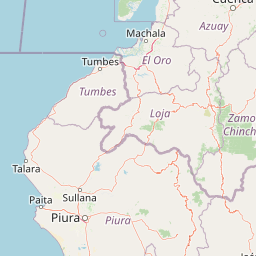
Map view of El Angolo Game Reserve

Use this park location map to pinpoint El Angolo Game Reserve in Peru, understand its exact geographic position, and read its mapped placement within the surrounding landscape more clearly.

Pigeon | © OpenStreetMap contributors

Location context for El Angolo Game Reserve

Piura Region
Recorded earthquake history

Examine the Seismic History and Recorded Earthquakes of El Angolo Game Reserve

Review documented seismic events and epicentre data associated with the landscapes of El Angolo Game Reserve. This MoriAtlas collection offers a structured perspective on regional earthquake activity, providing a detailed look at the historical records mapped to this protected territory.

El Angolo Game Reserve Earthquake History

Catalogued events

171 events

Strongest magnitude

Magnitude 7.2

Most recent event

Apr 14, 2026

This history includes earthquakes recorded inside the park or within 50 km of its borders

Park atlas

Compare adjacent dry forest reserves and regional conservation corridors across northwestern Peru

Explore Protected Areas and Parks Near El Angolo Game Reserve

Continue your geographic exploration by comparing El Angolo Game Reserve with other protected areas across the surrounding northwestern region. Examining adjacent natural habitats reveals broader ecological patterns and connected conservation landscapes.
National parkPeru
Park boundaries overlap#1 closest

Northeast

Cerros de Amotape National Park: Peru's Protected Pacific Tropical Forest Atlas

Explore mapped boundaries and diverse terrain of this unique landscape.

Cerros de Amotape National Park stands as a significant protected area within Peru, meticulously preserving remnants of the Tumbes-Piura dry forests and Pacific tropical forests. Situated within the Cordillera de los Amotapes, the park features a dynamic landscape from riverine habitats to elevated mountain terrain. This park detail page offers an atlas-style view, focusing on its geographic context, mapped protected boundaries, and its importance as a conservation corridor for unique biodiversity.

Area
1,515.61 km²
Established
1975
IUCN
II
Relief
Mountain
Nature reserveWestern Sahara
81 km away#2 closest

Northeast

Reserva ecológica Arenillas Nature Reserve: Geographic Landscape and Protected Area Context

Examining dry forest ecosystems and coastal habitat boundaries

Reserva ecológica Arenillas is a significant nature reserve, distinguished by its intact dry forest and coastal mangrove systems. The area serves as a key benchmark for regional conservation efforts, offering a detailed look at the interface between tropical shrubland and maritime environments through a protected geographic lens.

Area
131.65 km²
Established
2001
Relief
Lowland
Climate
Tropical
National parkZamora Chinchipe
137 km away#3 closest

East

Yacurí National Park: Protected Andean Lakes and Volcanic Landscape in Zamora Chinchipe

Discover highland geography and the ancient Inca Trail.

Yacurí National Park is a key protected landscape in Ecuador's southern Andes, celebrated for its remarkable collection of over 46 high-altitude lakes set within dramatic volcanic terrain. Situated in Zamora Chinchipe province, the park preserves a vital stretch of the Inca Trail, complete with archaeological sites. This national park offers a rich exploration of Andean geography, páramo ecosystems, and significant cultural heritage, making it a cornerstone of the region's protected areas.

Area
431 km²
Established
2009
IUCN
II
Relief
Mountain
National parkEcuador
163 km away#4 closest

East

Podocarpus National Park: Ecuador's Diverse National Park and Protected Landscape

Discover elfin forests, paramo, and over 100 lagoons.

Podocarpus National Park, situated in southeastern Ecuador, stands as a prime example of a protected natural area at a unique biogeographic crossroads. This national park spans dramatic elevational zones, from montane rain forests to high-elevation paramo ecosystems dotted with more than 100 lagoons, offering rich mapped landscape exploration. Its significance lies in the convergence of four distinct ecological systems, contributing to exceptional biodiversity and a rich tapestry of natural terrain.

Area
1,462.8 km²
Established
1982
IUCN
II
Relief
Mountain
Wildlife reserveGuayas
168 km away#5 closest

North

Refugio de Vida Silvestre Manglares El Morro: Protected Coastal Landscape and Map

A strategic marine and mangrove ecosystem in the Guayas Province

The landscape of Refugio de Vida Silvestre Manglares El Morro consists of continuous mangrove forests and rocky farallones, linked by a complex network of tidal channels. This wildlife refuge serves as an essential marine habitat at the threshold of the Gulf of Guayaquil, showcasing the interplay between tidal aquatic systems and coastal vegetation across the southwestern Ecuadorian region.

Area
101.3 km²
Established
2007
IUCN
Ib
Visitors
23K annual
Nature reserveZamora Chinchipe
196 km away#6 closest

East

Reserva Biológica Cerro Plateado: Andean and Amazonian Landscape and Protected Area Context

Vertical gradient and mountain forest geography in Zamora Chinchipe

Spanning elevations from 840 to 3,120 meters, Reserva Biológica Cerro Plateado represents a significant conservation effort within the Zamora Chinchipe province. The reserve preserves intact montane cloud forests and paramo, serving as a vital link between the eastern Andean slopes and the Nangaritza watershed in southeastern Ecuador.

Area
307.607 km²
Established
2010
IUCN
Ia
Relief
Mountain
A pale, soft watercolor painting showing a stylized, rolling landscape with light green, pink, and yellow hues representing hills and trees.
Nature reserveGuayas Province
198 km away#7 closest

Northeast

Reserva ecológica Manglares Churute: Mapping a Coastal Nature Reserve in Guayas Province

An ecological mosaic of mangrove forests, estuaries, and forested ridges.

Spanning from the inner Gulf of Guayaquil into the Churute hill range, Reserva ecológica Manglares Churute acts as an essential protected area within Ecuador. The region contains one of the country's most significant mangrove complexes, complemented by freshwater lagoons and unique fog-affected forest summits that support diverse wildlife populations and endemic vegetation.

Area
471.74 km²
Established
1979
IUCN
Ia
Relief
Mixed relief
Watercolor painting of a mountain landscape with a lake, rolling hills, and coniferous trees in soft green and yellow tones.
National parkAzuay
204 km away#8 closest

Northeast

Parque nacional Cajas: Mapping the Glacial Lakes and Paramo of the Ecuadorian Andes

Geographic analysis of high-elevation protected lands

Parque nacional Cajas encompasses a rugged, glacial-sculpted plateau characterized by cushion vegetation, boggy wetlands, and frequent fog. This protected area offers deep insight into the highland Andean geography of Azuay, where water bodies and mountain ridges intersect to form an essential ecological and cultural corridor for the region.

Area
293.89 km²
Established
1977
IUCN
II
Visitors
53K annual

Common questions about visiting, size, designation, and location context for El Angolo Game Reserve

El Angolo Game Reserve FAQs for park facts, access, geography, and protected area context

Find quick answers about El Angolo Game Reserve, including protected-area facts, park geography, trail and visitor context, and how the park fits into its surrounding country and regional landscape.
MoriAtlas Explorer

Continue Your Protected Areas Search Across the Global Atlas

Deepen your exploration by continuing the structured search for national parks and protected areas worldwide. Utilize the comprehensive filtering capabilities to compare different conservation landscapes and refine your understanding of global park geography. Discover more about the distribution and characteristics of protected natural areas.

Global natural geography


