Why Réserve naturelle régionale de l'étang du Pont de Fer stands out
The reserve is best known for the European otter that inhabits its waters, for the rich birdlife that uses the pond and surrounding habitats, and for the distinctive floating islets of tussock sedges colonised by alder and willow that characterise the pond's surface. The combination of a sizeable freshwater body, wooded buffer zones, and peripheral marshes gives the site an unusually high ecological density within a small footprint. It is also notable for its place within a continuum of coastal wetlands between the Vilaine estuary and the Guérande salt marshes, which underpins much of its ecological value as a stepping stone for wetland species in southern Brittany.
Réserve naturelle régionale de l'étang du Pont de Fer history and protected-area timeline
The pond at the heart of the reserve has a long human history. It was created by damming a valley in 1760, originally to support extensive fish farming. Over the following centuries, the site remained an active component of the local rural economy, with the dyke being repaired in 1920 and the pond experiencing several dry years during the 1960s.
In the early twenty-first century, the site's ecological value gained formal recognition. The Conservatoire du littoral acquired the pond and its surroundings at the beginning of 2005, providing long-term protection of sixty-two hectares of coastal wetland. This acquisition paved the way for stronger protective designation, and the reserve was officially classified on 27 June 2008 by decision of the regional council. It was formally inaugurated on 5 July 2010.
Since its classification, the reserve has been managed by the Conseil général de Loire-Atlantique. It benefits from multiple layers of recognition, including registration as a Site of Community Importance and as a ZNIEFF type I area, which together reinforce its role within the regional network of protected wetland sites.
Réserve naturelle régionale de l'étang du Pont de Fer landscape and geographic character
The landscape of the reserve is defined by a large, calm freshwater pond set in a low-lying coastal setting. The pond stretches roughly 1,500 metres in length with an average width of about 350 metres, sitting at an altitude of only around eight metres above sea level, which gives it a distinctly coastal, near-sea feel.
A defining physical feature is the dense wooded belt that encircles the water, creating a continuous green frame twenty-five to one hundred metres wide. This woodland ring is dominated by alder and willow, species adapted to saturated soils, and it visually isolates the pond from the surrounding agricultural parcels. Within the pond, tussock sedge mounds form small floating islets that periodically support young alders and willows, giving the surface a softly textured, vegetated appearance.
Beyond the reserve itself, the broader landscape context includes tidal channels, marshes, dunes, salt pans, and large estuarine systems. The étier du Foy, the pond's outlet, feeds into the étier de Pont-Mahé and links the site to the Guérande coastline. A road bridge along the departmental road CD 83, after which the pond is named, marks the main point of contact between the road network and the water.
Réserve naturelle régionale de l'étang du Pont de Fer ecosystems, habitats, and plant life
Ecologically, the reserve is centred on a mosaic of freshwater, wetland, and woodland habitats compressed into a relatively small area. The pond forms the core, surrounded by alder and willow woodland, floating sedge islets, and a network of peripheral ponds and marshes. Together, these habitats create a layered environment that supports a wide range of plant and animal communities.
Vegetation patterns are strongly shaped by water levels and soil saturation. Alder and willow dominate the wooded buffer, while tussock sedges structure the floating islets within the pond. In and around the water, several rare or notable plant species occur, including floating water-plantain, yellow water-lily, royal fern, marsh willowherb, bogbean, water violet, mare's tail, and milk parsley. Ten of the recorded plant species are classified on the regional red list, indicating their conservation significance in the Pays de la Loire and Brittany context.
The mosaic of habitats also supports a variety of ecological functions. The peripheral ponds add a secondary amphibian and aquatic habitat layer, the wooded fringes provide nesting and refuge opportunities, and the open water sustains fish, birds, and mammals. The site's ecological value is inseparable from its position in a wider connected network of coastal wetlands.
Réserve naturelle régionale de l'étang du Pont de Fer wildlife and species highlights
Wildlife is one of the main reasons the reserve holds protected status. The European otter is one of its signature species, using the pond and connecting waterways as part of its territory. The water also supports pike, a nationally protected freshwater fish, and eel, a migratory species whose presence here is marked by the arrival of glass eels.
The birdlife of the site is particularly rich for its size. A total of around eighty-eight bird species have been recorded, with twenty-five considered notable. These include charismatic and ecologically significant species such as the European kingfisher, the European nightjar, the marsh harrier, and the black woodpecker. The combination of open water, wooded edges, and nearby open landscapes supports a mix of waterbirds, woodland birds, and species of more open or rough terrain.
Amphibians are represented by around eight species, with the marbled newt, which breeds in the peripheral ponds, considered the most ecologically significant, particularly in the Pays de la Loire context. Invertebrate inventories at the site are still considered incomplete, suggesting that the full invertebrate diversity has yet to be documented. The peripheral pond system, rather than the main body of water, is the principal driver of amphibian and many invertebrate records.
Réserve naturelle régionale de l'étang du Pont de Fer conservation status and protection priorities
The reserve's main conservation significance lies in the combination of a sizeable freshwater pond, vegetated fringes, wooded buffer, and peripheral marshes protected under a strong legal framework. Created as a regional nature reserve in 2008, and reinforced by prior acquisition of the site by the Conservatoire du littoral in 2005, the area benefits from durable protection that goes beyond ordinary land-use regulation.
At a broader ecological scale, the reserve matters because it does not function in isolation. It is a node within a network of coastal wetlands that includes the Vilaine estuary, the Pénestin marshes, the Pont-Mahé dunes, the marais du Mès, the Guérande salt marshes, and the regional natural park of Brière. By maintaining the quality and connectivity of its habitats, it contributes to the wider conservation of wetland-dependent species in southern Brittany and the northern Pays de la Loire coast.
The site also benefits from multiple overlapping designations. Beyond its status as a regional nature reserve, it is recognised as a Site of Community Importance and as a ZNIEFF type I area, both of which highlight the importance of its flora, fauna, and wetland habitats at regional and European scales. The presence of regionally red-listed plant species and nationally protected species such as pike reinforces its conservation profile.
Réserve naturelle régionale de l'étang du Pont de Fer cultural meaning and human context
The site carries a layered human history. The pond itself was deliberately created by the damming of a valley in 1760 to support extensive fish farming, embedding the landscape with a long tradition of rural, small-scale water management. Repairs to the dyke in 1920 and the dry years of the 1960s reflect the ongoing interaction between local communities and the water.
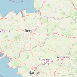
The pond's name comes from a bridge on the CD 83 departmental road, an indicator of how the site has long been integrated into local transport and land-use patterns. Its location between two regions and two departments, and its proximity to the town of Pénestin and the broader Pays de Guérande area, places it within a culturally rich coastal region known for salt-making, fishing, and coastal wetland heritage, even though the reserve itself does not overlap with the most visible cultural landscapes of the salt marshes and estuaries.
Top sights and standout views in Réserve naturelle régionale de l'étang du Pont de Fer
Among the reserve's strongest points of distinction are its European otter population, its rich avifauna of roughly eighty-eight species, and its remarkable floating sedge islets colonised by alder and willow. The continuity of the wooded belt around the pond and the presence of rare plant species, including several on the regional red list, further set it apart.
Equally important is its role as a link in the broader coastal wetland chain between the Vilaine estuary and the Guérande region. This combination of site-level richness and network-level significance makes the reserve an unusually valuable component of regional wetland conservation in western France.
Best time to visit Réserve naturelle régionale de l'étang du Pont de Fer
Because the reserve is small, lightly visited, and managed primarily for ecological protection rather than public access, the most appropriate timing is shaped by what one hopes to observe. Spring and early summer are generally the most rewarding periods for bird activity, amphibian presence in the peripheral ponds, and the growth of the surrounding woodland vegetation. Late spring into summer is also when floating islets and alder-willow fringes are most visibly green and structurally developed.
Autumn can bring changes in migratory bird presence and quieter conditions for observing waterbirds on the pond. Winter tends to be calmer, with reduced vegetation cover, which can make it easier to perceive the overall structure of the pond and its wooded ring from the bridge of the CD 83, the main viewpoint for the site. Given the limited public access, any visit is best planned as a short, observational stop rather than a longer excursion.