


Mori Atlas logo
Nature reserveRéserve naturelle régionale des étang et boisements de Joreau

Mapping the freshwater pond and woodland ecosystems of the Loire Valley protected landscape.

Réserve naturelle régionale des étang et boisements de Joreau: Regional Nature Reserve Geography

The Réserve naturelle régionale des étang et boisements de Joreau spans 92 hectares of protected land within the Maine-et-Loire department. This regional nature reserve preserves a distinct mosaic of freshwater pond habitats and surrounding deciduous woodlands, offering a representative glimpse into the ecological character of the lower Loire Valley landscape.

regional nature reservepond and woodlandwetland habitatfreshwater ecosystemdeciduous forestLoire Valley
Digital vector-style illustration of a mountainous landscape with a two-tiered waterfall flowing into a calm lake, surrounded by evergreen trees in the foreground.

Réserve naturelle régionale des étang et boisements de Joreau

Nature reserve

Park overview

Structured park overview, official facts, and landscape profile for Réserve naturelle régionale des étang et boisements de Joreau

Réserve naturelle régionale des étang et boisements de Joreau park facts, protected area profile, and essential visitor context

Review the core facts for Réserve naturelle régionale des étang et boisements de Joreau, including designation, size, terrain, visitor scale, habitats, and operating context in one park-focused overview.

About Réserve naturelle régionale des étang et boisements de Joreau

The Réserve naturelle régionale des étang et boisements de Joreau is a regional nature reserve in western France, classified in 2015 under the French regional nature reserve system. Covering 92 hectares, it is centered on a pond and the woodlands that surround it, creating a characteristic pairing of aquatic and forest habitats that defines its ecological identity. The reserve lies within the Pays de la Loire region, in the Maine-et-Loire department, on the territory of the communes of Chênehutte-Trèves-Cunault and Gennes.

This part of the Loire is strongly associated with river-valley landscapes, and Joreau fits within that broader pattern of water-influenced terrain and connected woodland. The reserve's small footprint is typical of regional nature reserves in France, which often focus on protecting locally significant habitats rather than large wilderness expanses. Its IUCN Category IV classification reflects an emphasis on the management and conservation of specific habitats and species rather than on broad ecosystem protection.

The site was created by formal decision of the Conseil régional on 28 September 2015, placing it within the growing network of regional nature reserves administered at the regional level in France, as distinct from national nature reserves and other protected-area designations. Although the available documentation on the reserve is limited, its inclusion in this network signals official recognition of its habitat value and its contribution to regional biodiversity conservation in the Anjou portion of the Loire Valley.

Protection and recognition

Review documented conservation status, designation history, and administrative records.

Protection Status and International Recognition for Réserve naturelle régionale des étang et boisements de Joreau

Examine the recorded protection status and official database attributes for Réserve naturelle régionale des étang et boisements de Joreau. Review verified management entries and global dataset identifiers without administrative speculation.

Protection details

WDPA ID
555597271
Park context

Deeper park guide and search-rich context for Réserve naturelle régionale des étang et boisements de Joreau

Réserve naturelle régionale des étang et boisements de Joreau history, landscape, wildlife, and travel context

Explore Réserve naturelle régionale des étang et boisements de Joreau through its history, landscape character, ecosystems, wildlife, conservation priorities, cultural context, and seasonal travel timing in a structured park guide built for atlas discovery and search intent.

Réserve naturelle régionale des étang et boisements de Joreau history and protected-area timeline

The reserve was formally established on 28 September 2015, when it was classified by a deliberation of the Conseil régional of Pays de la Loire. Its creation marks its entry into the French system of regional nature reserves (réserves naturelles régionales), a designation that allows regional authorities to protect areas of ecological interest under their own jurisdiction. Beyond the founding decision, the publicly available overview does not provide further detail about the site's pre-classificaton land use, earlier protection efforts, or the specific conservation history of the étang and woodlands that make up the reserve.

Réserve naturelle régionale des étang et boisements de Joreau landscape and geographic character

The landscape of the reserve is defined by the combination implied in its name: an étang, or pond, and the surrounding boisements, or woodlands. This pairing is characteristic of the gently undulating countryside of the Maine-et-Loire, where small freshwater bodies are often fringed by deciduous forest. The lower Loire setting, near the communes of Chênehutte-Trèves-Cunault and Gennes, places the reserve within a broader environment shaped by the river system of the Loire and its tributaries.

With 92 hectares in total, Joreau is a compact site, and its terrain reflects the modest scale typical of regional nature reserves in highly cultivated French regions. The visual character is likely dominated by water surfaces, wooded margins, and the transitional zones where pond and forest meet, a configuration that is ecologically valuable and visually distinctive within the regional context.

Réserve naturelle régionale des étang et boisements de Joreau ecosystems, habitats, and plant life

The reserve's ecological profile centers on a pond-and-woodland mosaic, combining freshwater habitat with broadleaf forest stands typical of the Anjou landscape. Such a configuration generally supports a mix of aquatic, wetland-margin, and woodland species, with the pond serving as a focal point for water-associated biodiversity and the surrounding woodlands providing habitat continuity and shelter. As a regional nature reserve under IUCN Category IV, the site's ecological purpose is oriented toward habitat and species management within a relatively small spatial footprint.

Réserve naturelle régionale des étang et boisements de Joreau conservation status and protection priorities

Although detailed ecological documentation about the reserve is limited, its classification as a regional nature reserve under IUCN Category IV indicates an explicit focus on conserving particular habitats and species. The pond-and-woodland combination it protects is ecologically meaningful within the intensively used landscapes of the Loire Valley, where small natural and semi-natural patches can play a disproportionate role in maintaining regional biodiversity. The reserve also contributes to the broader network of French regional nature reserves that collectively protect representative ecosystems across metropolitan France.
Monthly climate preview

Long-term representative temperature and precipitation patterns across twelve recorded months.

Réserve naturelle régionale des étang et boisements de Joreau Climate Normals Preview

Historical climate normals for Réserve naturelle régionale des étang et boisements de Joreau outline a measured annual progression of average temperatures and daily precipitation rates. Detailed monthly comparisons illustrate the full range of temperature extremes and multi-year meteorological averages recorded at this coordinate.
Annual mean12 °C
4 °C20 °C
Jan
Feb
Mar
Apr10°
May14°
Jun18°
Jul20°
Aug20°
Sep17°
Oct12°
Nov
Dec
Warmest month
August

20 °C

Coolest month
January

4.3 °C

Wettest month
December

2.5 mm/day

Driest month
August

1.5 mm/day

Park location guide

Geography guide, regional context, and park location map for Réserve naturelle régionale des étang et boisements de Joreau

Réserve naturelle régionale des étang et boisements de Joreau park geography, regions, and map view in France

Understand where Réserve naturelle régionale des étang et boisements de Joreau sits in France through a broader geographic reading of the surrounding landscape, nearby location context, and its mapped position within the national park landscape.

How Réserve naturelle régionale des étang et boisements de Joreau fits into France

France is a unitary semi-presidential republic and one of the world's largest economies. It borders Belgium, Luxembourg, Germany, Switzerland, Italy, Monaco, Andorra, and Spain, with a maritime border to the United Kingdom. The country is known for its cultural influence, art, cuisine, and political history spanning centuries.

Wider geography shaping Réserve naturelle régionale des étang et boisements de Joreau in France

France is located in Western Europe. Metropolitan France extends from the Rhine to the Atlantic Ocean and from the Mediterranean Sea to the English Channel and North Sea. The country borders Belgium, Luxembourg, Germany, Switzerland, Italy, Monaco, Andorra, Spain, and has a maritime border with the United Kingdom.

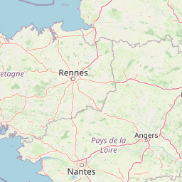
Map view of Réserve naturelle régionale des étang et boisements de Joreau

Use this park location map to pinpoint Réserve naturelle régionale des étang et boisements de Joreau in France, understand its exact geographic position, and read its mapped placement within the surrounding landscape more clearly.

Pigeon | © OpenStreetMap contributors

Location context for Réserve naturelle régionale des étang et boisements de Joreau

Pays de la Loire

Examine the freshwater ponds, deciduous woodlands, and protected wetland habitats defining the terrain.

Visual Explorer: Réserve naturelle régionale des étang et boisements de Joreau Photos and Landscape Scenery

Visual records capture the distinctive mosaic of pond waters and surrounding woodlands across the regional reserve landscape. Photographic documentation reveals the habitat features and terrain characteristics typical of the lower Loire Valley ecosystem.

A wide, calm pond with reeds in the foreground and a dense line of trees on the horizon under a clear sky.

Park atlas

Compare adjacent wetland habitats and protected landscapes across the lower Loire Valley

Parks Near Réserve Naturelle Régionale Des Étang Et Boisements De Joreau

Browse nearby protected areas and regional reserves sharing similar wetland and forest ecosystems within the surrounding Pays de la Loire territory. Comparing adjacent conservation landscapes reveals how regional management frameworks protect fragmented habitats along the lower Loire river basin.
Nature reservePays de la Loire
About 24 km away#1 closest

South

Réserve naturelle régionale Champagne de Méron: Geographic and Protected Area Overview

A regional nature reserve within the Maine-et-Loire department.

Located in the heart of the Anjou countryside, Réserve naturelle régionale Champagne de Méron represents a strategic effort to safeguard biodiversity within western France. Covering 146 hectares, this protected area illustrates the intersection of modern conservation goals and historic rural landscapes, offering a clear view of how regional authorities manage and restore fragmented natural habitats.

Area
1.461 km²
Established
2023
IUCN
IV
Scope
Terrestrial
Nature reservePays de la Loire
About 33 km away#2 closest

West

Réserve naturelle régionale de Basses-Brosses et Chevalleries: Protected Area Mapping

A dense bocage landscape in the Pays de la Loire region

This regional nature reserve protects a well-preserved mosaic of meadows, cultivated plots, and wooded hedgerows across 90 hectares. The site serves as a vital ecological anchor in the Maine-et-Loire department, maintaining traditional land patterns and diverse species habitats that define the historic rural character of the Anjou countryside.

Area
0.9 km²
Established
2012
IUCN
IV
Nature reserveNouvelle-Aquitaine
About 36 km away#3 closest

South

Réserve naturelle nationale du Toarcien: Protected Jurassic Stratotype and Geological Map

A vital paleontological heritage site in the Nouvelle-Aquitaine region

As the smallest national nature reserve in France, Réserve naturelle nationale du Toarcien provides a concentrated, scientifically essential view of Jurassic marine sediments. The protected quarries preserve ammonite-rich strata and complex geological unconformities, serving as the international definition for the Toarcian geological stage within the Thouet valley landscape.

Area
0.006 km²
Established
1987
IUCN
III
Relief
Lowland
Nature reserveCentre-Val de Loire
About 38 km away#4 closest

Southeast

Marais de Taligny Regional Nature Reserve: A Protected Wetland in Centre-Val de Loire

Alluvial valley geography and restored marshland habitats

Spanning the Négron valley, this regional nature reserve serves as an vital sanctuary for alkaline fen formations and diverse aquatic species. The site provides a detailed look at the intersection of riverine drainage, alluvial woodland, and the successful ecological restoration of historical French wetland landscapes.

Area
0.354 km²
Established
2014
IUCN
IV
Relief
Lowland
Nature reserveNouvelle-Aquitaine
About 39 km away#5 closest

South

Réserve naturelle régionale de la vallée du Pressoir: Protected Limestone Valley and Geoheritage

A rare natural and cultural mosaic in Nouvelle-Aquitaine

Trace the boundaries and natural features of the Réserve naturelle régionale de la vallée du Pressoir. This protected site in the Deux-Sèvres department is defined by thin calcareous soils, the historic Pommiers cascade, and fossil-rich limestone outcrops that form an unusual geoheritage landscape.

Area
0.56 km²
Established
2025
IUCN
IV
Visitors
10K annual
Nature reservePays de la Loire
About 40 km away#6 closest

North

Réserve naturelle régionale des marais de Cré-sur-Loir et La Flèche Protected Landscape

Wetland ecosystems in the Pays de la Loire region.

Spanning an old meander of the Loir river, this regional nature reserve preserves a complex network of marshes, canals, and alluvial forests. Learn about its unique floodplain geography and the protected wetland habitats that sustain regional biodiversity in the heart of the Sarthe department.

Area
0.531 km²
Established
2008
IUCN
IV
Relief
Lowland
Nature reservePays de la Loire
About 48 km away#7 closest

Northeast

Réserve naturelle régionale du coteau et prairies des Caforts: Protected Area and Map Atlas

A diverse protected landscape in the Pays de la Loire region

Situated in the Loir valley, this regional nature reserve combines three distinct landscape types: dry limestone slopes, humid hay meadows, and 910 meters of man-made tuffeau quarry galleries. The site represents a significant pocket of biodiversity, hosting sixteen bat species and rare flora within its compact protected footprint in Sarthe.

Area
0.064 km²
Established
2009
IUCN
IV
Nature reservePays de la Loire
About 54 km away#8 closest

Northeast

Réserve naturelle régionale des prairies et roselière des Dureaux: Loir Valley Protected Landscapes

Regional Nature Reserve in Pays de la Loire, France

Spanning the alluvial plains near Vaas, this reserve protects essential wet meadows and reedbed communities shaped by the seasonal rhythm of the Loir River. The landscape features a classic bocage character, offering a distinct example of wetland conservation within the Pays de la Loire region.

Area
0.253 km²
Established
2001
IUCN
IV
Relief
Lowland

Common questions about visiting, size, designation, and location context for Réserve naturelle régionale des étang et boisements de Joreau

Réserve naturelle régionale des étang et boisements de Joreau FAQs for park facts, access, geography, and protected area context

Find quick answers about Réserve naturelle régionale des étang et boisements de Joreau, including protected-area facts, park geography, trail and visitor context, and how the park fits into its surrounding country and regional landscape.
MoriAtlas Explorer

Continue Your Protected Areas Search Across the Global Atlas

Deepen your exploration by continuing the structured search for national parks and protected areas worldwide. Utilize the comprehensive filtering capabilities to compare different conservation landscapes and refine your understanding of global park geography. Discover more about the distribution and characteristics of protected natural areas.

Global natural geography