Mori Atlas logo
Nature reserveRéserve naturelle régionale des prairies et roselière des Dureaux

Explore the alluvial floodplain, wet meadows, and marshland reedbed habitats within this French regional nature reserve.

Réserve naturelle régionale des prairies et roselière des Dureaux: Protected Wetland Landscapes and Geography in Pays de la Loire

The Réserve naturelle régionale des prairies et roselière des Dureaux occupies a vital stretch of the Loir River valley in the Sarthe department of Pays de la Loire. This protected area preserves a mosaic of seasonally flooded wet meadows and expansive reedbed ecosystems that define the local alluvial geography. As part of the broader Loir valley landscape, the reserve functions as a critical wetland corridor where the interplay of periodic river flooding and traditional bocage terrain supports a unique array of flora and fauna in western France.

wetland reserveregional nature reservewet meadowsreedbedfloodplainLoir valley

Réserve naturelle régionale des prairies et roselière des Dureaux

Nature reserve

Park overview

Structured park overview, official facts, and landscape profile for Réserve naturelle régionale des prairies et roselière des Dureaux

Réserve naturelle régionale des prairies et roselière des Dureaux park facts, protected area profile, and essential visitor context

Review the core facts for Réserve naturelle régionale des prairies et roselière des Dureaux, including designation, size, terrain, visitor scale, habitats, and operating context in one park-focused overview.

About Réserve naturelle régionale des prairies et roselière des Dureaux

The Réserve naturelle régionale des prairies et roselière des Dureaux occupies a small but ecologically rich section of the Loir valley floodplain in southern Sarthe. Set near the village of Vaas, it preserves a piece of the traditional valley landscape where meadow, marsh, reedbed, and bocage meet along one of the slower western tributaries of the Loire basin. The reserve's identity is shaped by water: the regular rise and fall of the Loir maintains the wet meadows, replenishes the reedbed, and sustains the hydrological conditions on which many of its species depend.

The reserve's main habitats are humid prairies, a substantial reedbed, and the surrounding hedgerow mosaic. Together these form a coherent wetland complex that is increasingly rare in a region historically dominated by agriculture. The wet meadows host a diverse flora of more than 200 plant species, including several that are protected or considered regionally notable across the Pays de la Loire and western France.

Beyond its botanical richness, the site is valued as a quiet refuge for wetland birds, amphibians, and insects that depend on undisturbed marsh and wet grassland. Despite its modest size, the reserve plays an outsize role in local conservation, providing a protected reference area within a wider working agricultural landscape and contributing to broader wetland networks in the Loir valley.

Quick facts and research context for Réserve naturelle régionale des prairies et roselière des Dureaux

Located in the Pays de la Loire region, in the southern Sarthe department, approximately 2 km from the village of Vaas, the reserve lies in the alluvial floodplain of the Loir River. The site protects wet meadows, a reedbed, and surrounding bocage habitats typical of the lower Loir valley.

Classified as a regional nature reserve on 28 September 2009, the site originated as a voluntary nature reserve in December 2001 and was extended in 2023 to roughly 25 hectares of protected habitat. Its ecological interest is recognised within the broader ZNIEFF "Marais des Dureaux, des Belles et de la Noé-Guy", and it is classified under IUCN Category IV.

Protection and recognition

Examine documented terrestrial designation history and formal conservation scope for this protected area.

Protection Status and International Recognition for Réserve naturelle régionale des prairies et roselière des Dureaux

Terrestrial protection status for Réserve naturelle régionale des prairies et roselière des Dureaux establishes formal designation history dating back to 2009. Official records trace conservation scope and administrative identifiers to contextualize protected area management without additional international recognition sources.

Protection details

Protection scope
Terrestrial
Designated year
2009
Transboundary protection
No
WDPA ID
555513709
Park context

Deeper park guide and search-rich context for Réserve naturelle régionale des prairies et roselière des Dureaux

Réserve naturelle régionale des prairies et roselière des Dureaux history, landscape, wildlife, and travel context

Explore Réserve naturelle régionale des prairies et roselière des Dureaux through its history, landscape character, ecosystems, wildlife, conservation priorities, cultural context, and seasonal travel timing in a structured park guide built for atlas discovery and search intent.

Why Réserve naturelle régionale des prairies et roselière des Dureaux stands out

The reserve is especially known for its floodplain wet meadows, or prairies humides, that depend directly on the seasonal flooding rhythm of the Loir River. Associated with these meadows is a rich roselière, a tall reedbed community that has become a notable habitat feature of the site. The combination of regularly inundated grassland, reedbed vegetation, and the surrounding hedgerow landscape gives the reserve its distinctive ecological character and supports several regionally significant wetland species.

Réserve naturelle régionale des prairies et roselière des Dureaux history and protected-area timeline

The site first received formal protection on 18 December 2001, when it was classified as a réserve naturelle volontaire, or voluntary nature reserve, through the commitment of local conservation partners. The designation was short-lived at the national level: the 2002 "Démocratie de proximité" law abolished the voluntary reserve category, removing that specific legal framework.

Recognising the site's ecological value, the Pays de la Loire regional council acting under the new framework created a réserve naturelle régionale by deliberation on 28 September 2009, re-establishing and strengthening protection. On 17 November 2023, a further deliberation extended the reserve's perimeter and updated its regulations, allowing the protected area to better encompass the surrounding wetland mosaic and reinforcing its long-term conservation role.

Réserve naturelle régionale des prairies et roselière des Dureaux landscape and geographic character

The reserve sits at the heart of the Loir valley, a broad alluvial corridor characterised by gentle slopes, slow-moving water, and centuries of pastoral use. The protected area is essentially a floodplain landscape, shaped by the seasonal hydrology of the Loir River, which periodically inundates the lower meadows and replenishes the wetland system.

Around the wet meadows and reedbed, the landscape is framed by bocage, a traditional pattern of small fields and pastures enclosed by hedgerows, tree lines, and sunken lanes. This mix of open grassland, marshy reedbeds, and wooded boundaries gives the Dureaux reserve a layered visual character, where flat wetland vistas alternate with the enclosed, intimate geometry of the surrounding countryside.

Réserve naturelle régionale des prairies et roselière des Dureaux ecosystems, habitats, and plant life

Ecologically, the reserve is defined by two strongly linked habitat types: wet meadows recharged by Loir floods and a central reedbed community. The prairies humides support a wide range of moisture-loving plants and serve as the principal feeding and breeding habitat for many of the site's birds, amphibians, and invertebrates. The roselière, dominated by tall reeds and marsh vegetation, offers denser cover and acts as a refuge area for secretive wetland species.

These wetland habitats are embedded within a wider bocage matrix of hedgerows, scattered trees, and small fields, which provides structural diversity and ecological connectivity across the valley floor. The combination of open, periodically flooded ground, tall marsh vegetation, and enclosed hedgerow edge habitats gives the reserve a layered ecological profile characteristic of floodplain landscapes in western France.

Réserve naturelle régionale des prairies et roselière des Dureaux wildlife and species highlights

The reserve is most notable for its birdlife, which reflects the value of the roselière and adjoining wet meadows. Among the recorded avifauna are the corncrake, a notoriously secretive grassland species, the Savi's warbler, the water rail, and the whinchat, all of which favour marshy and wet-grassland habitats.

Amphibians are also well represented, with agile frog, common toad, European tree frog, and green frog documented on the site, taking advantage of the wet ditches, temporary pools, and saturated meadows. The large copper butterfly, a marshland specialist, has been recorded here, reinforcing the reserve's importance for wetland invertebrates as well as vertebrates.

Réserve naturelle régionale des prairies et roselière des Dureaux conservation status and protection priorities

The reserve's conservation value lies in the preservation of a functioning floodplain habitat complex in a working agricultural landscape. By protecting periodically inundated meadows, a tall reedbed, and their associated bocage surroundings, it safeguards habitat types that have declined significantly across western France due to drainage, intensification, and land-use change.

The site contributes to broader conservation through its recognition within the ZNIEFF "Marais des Dureaux, des Belles et de la Noé-Guy", integrating it into a wider inventory of valuable natural areas. The 2023 perimeter extension was explicitly designed to strengthen the protection of the connected wetland mosaic, ensuring that the hydrological and ecological dynamics of the Loir floodplain continue to support their characteristic species communities.

Réserve naturelle régionale des prairies et roselière des Dureaux cultural meaning and human context

The landscape protected by the reserve is inseparable from the long pastoral and agricultural traditions of the lower Loir valley. The bocage of hedgerows and small fields, the hay meadows, and the rural paths that cross the site all reflect centuries of valley farming shaped by the rhythms of the Loir's seasonal floods. The site is firmly anchored in the local identity of southern Sarthe, where Vaas and the surrounding villages have historically depended on the valley's meadows, water, and wooded edges.

Top sights and standout views in Réserve naturelle régionale des prairies et roselière des Dureaux

A core area of prairies humides maintained by the natural flooding cycle of the Loir River, set within a classic Loir valley bocage landscape near Vaas. A substantial roselière that provides key nesting and refuge habitat for secretive marshland species. More than 200 recorded plant species, including several regionally rare wetland plants such as Ranunculus ophioglossifolius, Gratiola officinalis, and the greater spearwort. A rich wetland bird community featuring corncrake, Savi's warbler, and water rail, alongside amphibians and wetland butterflies such as the large copper. Enhanced protection through its 2023 extension and inclusion in the broader Dureaux-Belles-Noé-Guy ZNIEFF complex.

Best time to visit Réserve naturelle régionale des prairies et roselière des Dureaux

Late spring and early summer are generally the most rewarding periods to experience the reserve, when the wet meadows are at their most florally diverse and many bird species, including warblers and whinchats, are active and vocal along the reedbed and meadow edges. Late spring is also a good window for observing amphibians around the wet ditches and temporary pools.

Visiting in drier summer weeks can offer more comfortable walking conditions along the chemin des Dureaux, though the meadows will appear more parched and bird activity may be reduced. Winter visits can be quiet but may reveal waterbirds and highlights of the open floodplain landscape, particularly after flood events have refreshed the wetland vegetation.
Monthly climate preview

Long-term temperature ranges and monthly precipitation patterns across the protected landscape

Réserve naturelle régionale des prairies et roselière des Dureaux Climate Normals

Representative coordinates record measured annual temperature variation alongside steady monthly precipitation rates from historical NASA climatology data. Examining the complete twelve-month record reveals deeper baseline patterns across the protected terrain.
Annual mean12 °C
4 °C20 °C
Jan
Feb
Mar
Apr10°
May14°
Jun18°
Jul20°
Aug20°
Sep17°
Oct12°
Nov
Dec
Warmest month
August

20 °C

Coolest month
January

4.3 °C

Wettest month
December

2.5 mm/day

Driest month
August

1.5 mm/day

Park location guide

Geography guide, regional context, and park location map for Réserve naturelle régionale des prairies et roselière des Dureaux

Réserve naturelle régionale des prairies et roselière des Dureaux park geography, regions, and map view in France

Understand where Réserve naturelle régionale des prairies et roselière des Dureaux sits in France through a broader geographic reading of the surrounding landscape, nearby location context, and its mapped position within the national park landscape.

How Réserve naturelle régionale des prairies et roselière des Dureaux fits into France

France is a unitary semi-presidential republic and one of the world's largest economies. It borders Belgium, Luxembourg, Germany, Switzerland, Italy, Monaco, Andorra, and Spain, with a maritime border to the United Kingdom. The country is known for its cultural influence, art, cuisine, and political history spanning centuries.

Wider geography shaping Réserve naturelle régionale des prairies et roselière des Dureaux in France

France is located in Western Europe. Metropolitan France extends from the Rhine to the Atlantic Ocean and from the Mediterranean Sea to the English Channel and North Sea. The country borders Belgium, Luxembourg, Germany, Switzerland, Italy, Monaco, Andorra, Spain, and has a maritime border with the United Kingdom.

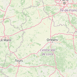
Map view of Réserve naturelle régionale des prairies et roselière des Dureaux

Use this park location map to pinpoint Réserve naturelle régionale des prairies et roselière des Dureaux in France, understand its exact geographic position, and read its mapped placement within the surrounding landscape more clearly.

Pigeon | © OpenStreetMap contributors

Location context for Réserve naturelle régionale des prairies et roselière des Dureaux

Pays de la Loire
Park atlas

Discover related protected areas and wetland landscapes across the surrounding regional terrain.

Parks near Réserve naturelle régionale des prairies et roselière des Dureaux

Browse other protected areas and wetland reserves connected to the environmental profile of Réserve naturelle régionale des prairies et roselière des Dureaux. Comparing adjacent valley habitats helps contextualize regional floodplain conservation and river corridor ecosystems.
Nature reservePays de la Loire
About 15 km away#1 closest

West

Réserve naturelle régionale du coteau et prairies des Caforts: Protected Area and Map Atlas

A diverse protected landscape in the Pays de la Loire region

Situated in the Loir valley, this regional nature reserve combines three distinct landscape types: dry limestone slopes, humid hay meadows, and 910 meters of man-made tuffeau quarry galleries. The site represents a significant pocket of biodiversity, hosting sixteen bat species and rare flora within its compact protected footprint in Sarthe.

Area
0.064 km²
Established
2009
IUCN
IV
A watercolor painting showing a soft, stylized landscape with rolling green hills, small clusters of trees, and a winding waterway, with tall grass and flowers in the foreground.
Nature reservePays de la Loire
About 30 km away#2 closest

North

Réserve naturelle régionale du bas-marais tourbeux de la Basse-Goulandière: Regional Wetland Mapping

A rare alkaline lowland peatland within the Pays de la Loire administrative region

Examine the mapped terrain and habitat structure of this protected peatland near Le Mans. This site preserves an uncommon alkaline mire environment, serving as an essential ecological bridge within the Roule-Crottes stream valley and demonstrating the significant conservation value of small, high-quality wetland pockets in agricultural landscapes.

Area
0.38 km²
Established
2011
IUCN
IV
Nature reservePays de la Loire
About 33 km away#3 closest

West

Réserve naturelle régionale des marais de Cré-sur-Loir et La Flèche Protected Landscape

Wetland ecosystems in the Pays de la Loire region.

Spanning an old meander of the Loir river, this regional nature reserve preserves a complex network of marshes, canals, and alluvial forests. Learn about its unique floodplain geography and the protected wetland habitats that sustain regional biodiversity in the heart of the Sarthe department.

Area
0.531 km²
Established
2008
IUCN
IV
Relief
Lowland
A soft watercolor illustration featuring a calm pond in the foreground, with reeds on the right and a distant treeline and rolling hills in the background.
Nature reservePays de la Loire
About 54 km away#4 closest

Southwest

Réserve naturelle régionale des étang et boisements de Joreau: Protected Area Atlas Profile

Wetland and woodland mosaic in the Pays de la Loire region.

This profile examines the 92-hectare Réserve naturelle régionale des étang et boisements de Joreau, a protected area in the Maine-et-Loire department. The site features a specialized composition of freshwater ponds and mature woodlands, reflecting the traditional riverine landscapes found throughout the broader Loire Valley regional geography.

Area
0.92 km²
Established
2015
IUCN
IV
Nature reserveCentre-Val de Loire
About 60 km away#5 closest

South

Marais de Taligny Regional Nature Reserve: A Protected Wetland in Centre-Val de Loire

Alluvial valley geography and restored marshland habitats

Spanning the Négron valley, this regional nature reserve serves as an vital sanctuary for alkaline fen formations and diverse aquatic species. The site provides a detailed look at the intersection of riverine drainage, alluvial woodland, and the successful ecological restoration of historical French wetland landscapes.

Area
0.354 km²
Established
2014
IUCN
IV
Relief
Lowland
Nature reservePays de la Loire
About 68 km away#6 closest

Southwest

Réserve naturelle régionale Champagne de Méron: Geographic and Protected Area Overview

A regional nature reserve within the Maine-et-Loire department.

Located in the heart of the Anjou countryside, Réserve naturelle régionale Champagne de Méron represents a strategic effort to safeguard biodiversity within western France. Covering 146 hectares, this protected area illustrates the intersection of modern conservation goals and historic rural landscapes, offering a clear view of how regional authorities manage and restore fragmented natural habitats.

Area
1.461 km²
Established
2023
IUCN
IV
Scope
Terrestrial
Nature reservePays de la Loire
About 75 km away#7 closest

West

Réserve naturelle régionale de Basses-Brosses et Chevalleries: Protected Area Mapping

A dense bocage landscape in the Pays de la Loire region

This regional nature reserve protects a well-preserved mosaic of meadows, cultivated plots, and wooded hedgerows across 90 hectares. The site serves as a vital ecological anchor in the Maine-et-Loire department, maintaining traditional land patterns and diverse species habitats that define the historic rural character of the Anjou countryside.

Area
0.9 km²
Established
2012
IUCN
IV
A watercolor painting showing a soft, pastoral landscape with green rolling hills, light yellow grasslands, and a tranquil pond in the foreground against a light, hazy sky.
Nature reservePays de la Loire
About 78 km away#8 closest

North

Réserve naturelle régionale du coteau et plateau de Tessé: Protected Limestone Geography

Calcareous grassland landscapes in the Sarthe department

Examine the geography of this regional nature reserve in Pays de la Loire. The site preserves a compact parcel of limestone plateau and slopes, offering a concentrated look at dry calcareous habitat conservation and the distinct geology of the Rutin valley area.

Area
0.056 km²
Established
2009
IUCN
IV
Relief
Upland

Common questions about visiting, size, designation, and location context for Réserve naturelle régionale des prairies et roselière des Dureaux

Réserve naturelle régionale des prairies et roselière des Dureaux FAQs for park facts, access, geography, and protected area context

Find quick answers about Réserve naturelle régionale des prairies et roselière des Dureaux, including protected-area facts, park geography, trail and visitor context, and how the park fits into its surrounding country and regional landscape.
MoriAtlas Explorer

Continue Your Protected Areas Search Across the Global Atlas

Deepen your exploration by continuing the structured search for national parks and protected areas worldwide. Utilize the comprehensive filtering capabilities to compare different conservation landscapes and refine your understanding of global park geography. Discover more about the distribution and characteristics of protected natural areas.

Global natural geography