
Mori Atlas logo
Nature reserveRéserve naturelle régionale du bas-marais tourbeux de la Basse-Goulandière

Mapping the rare alkaline peatland ecosystems and habitat mosaics of the Sarthe department

Réserve naturelle régionale du bas-marais tourbeux de la Basse-Goulandière: Protected Wetland Geography

Spanning approximately 38 hectares near Parigné-l'Évêque, this protected site represents a rare survival of alkaline lowland peatlands in the Sarthe department of Pays de la Loire. The landscape forms a dense mosaic where groundwater-fed mires meet marshland, heathland, and woodland. This protected area functions as a vital wetland anchor, supporting rare plant species, dragonfly populations, and diverse bat communities within the broader context of western French ecological networks.

peatlandalkaline mirewetlandregional nature reserveSarthePays de la Loire
A digital illustration of a marshy landscape with a winding stream in the foreground, tall trees on either side, and low hills in the distance under a pale sky.

Réserve naturelle régionale du bas-marais tourbeux de la Basse-Goulandière

Nature reserve

Park overview

Structured park overview, official facts, and landscape profile for Réserve naturelle régionale du bas-marais tourbeux de la Basse-Goulandière

Réserve naturelle régionale du bas-marais tourbeux de la Basse-Goulandière park facts, protected area profile, and essential visitor context

Review the core facts for Réserve naturelle régionale du bas-marais tourbeux de la Basse-Goulandière, including designation, size, terrain, visitor scale, habitats, and operating context in one park-focused overview.

About Réserve naturelle régionale du bas-marais tourbeux de la Basse-Goulandière

The Réserve naturelle régionale du bas-marais tourbeux de la Basse-Goulandière is a small but ecologically rich protected area in the Sarthe, a department in the Pays de la Loire region of north-western France. It lies on the territory of Parigné-l'Évêque, roughly twelve kilometres southeast of Le Mans, along the valley of the small Roule-Crottes stream. The reserve occupies about 38 hectares of lowland countryside that would, without protection, have been at high risk of agricultural drainage or conversion.

The defining feature of the site is its alkaline lowland peatland, a bas-marais tourbeux et alcalin, which is increasingly rare in western France. Peat has accumulated here in conditions linked to groundwater seepage and the slow movement of water through the valley floor. The peatland sits within a wider landscape mosaic that includes marsh, wet meadow, dry heath, and woodland, so a relatively short walk can take visitors from open mire communities into shaded forest edge.

Ecologically, the reserve functions as a refuge for specialised wetland plants and for the invertebrates, amphibians, and small mammals that depend on them. Because the bas-marais is one of the last of its kind in the Sarthe, it carries significance beyond its modest size, acting as a reference site for regional wetland conservation. The surrounding woodlands and stream-side habitat extend the reserve's ecological role and connect it to a larger Natura 2000 area focused on the Narais valley and the Bercé forest.

Beyond its conservation function, the reserve has a clear educational role. Marked forest paths on the eastern side of the site allow visitors to discover the wetland without disturbing sensitive areas, and the mosaic of habitats makes it a useful outdoor classroom for understanding lowland mire ecology in an easily accessible rural setting.

Quick facts and research context for Réserve naturelle régionale du bas-marais tourbeux de la Basse-Goulandière

The reserve is a French régionale nature reserve covering roughly 38 hectares in the Sarthe department, within the Pays de la Loire region. It is located on the commune of Parigné-l'Évêque, near the Roule-Crottes stream, and lies within the Natura 2000 Site of Community Importance FR5200647 'Vallée du Narais, forêt de Bercé et ruisseau du Dinan'. Created on 28 January 2011 by regional council deliberation following a favourable opinion from the CSRPN, it succeeded an earlier 2001 voluntary nature reserve classification that ended with the 2002 'Démocratie de proximité' law. Land has been owned by the commune since 1966, with conservation management delegated to the Sarthe Conservatoire d'espaces naturels since 1997.

Protection and recognition

Documented protection records and global database identifiers for this regional nature reserve

Protection Status and International Recognition for Réserve naturelle régionale du bas-marais tourbeux de la Basse-Goulandière

Examine the official protection status, management framework, and WDPA database identifiers recorded for Réserve naturelle régionale du bas-marais tourbeux de la Basse-Goulandière. Review structured conservation metrics and formal designation records associated with this protected natural area.

Protection details

WDPA ID
555559602
Park context

Deeper park guide and search-rich context for Réserve naturelle régionale du bas-marais tourbeux de la Basse-Goulandière

Réserve naturelle régionale du bas-marais tourbeux de la Basse-Goulandière history, landscape, wildlife, and travel context

Explore Réserve naturelle régionale du bas-marais tourbeux de la Basse-Goulandière through its history, landscape character, ecosystems, wildlife, conservation priorities, cultural context, and seasonal travel timing in a structured park guide built for atlas discovery and search intent.

Why Réserve naturelle régionale du bas-marais tourbeux de la Basse-Goulandière stands out

The Basse-Goulandière reserve is best known for protecting one of the rare alkaline lowland peatlands remaining in the Sarthe, a habitat type that has largely disappeared from agricultural lowland France. The site combines an active bas-marais with adjacent marshland, heathland, and woodland, creating a compact mosaic of wet and dry conditions within just a few dozen hectares. It is also recognised for its rich and well-documented flora and fauna. Seven nationally protected plant species grow in the mires, and the fauna includes protected dragonflies, the great crested newt, and a notable bat community, with eleven bat species recorded on-site.
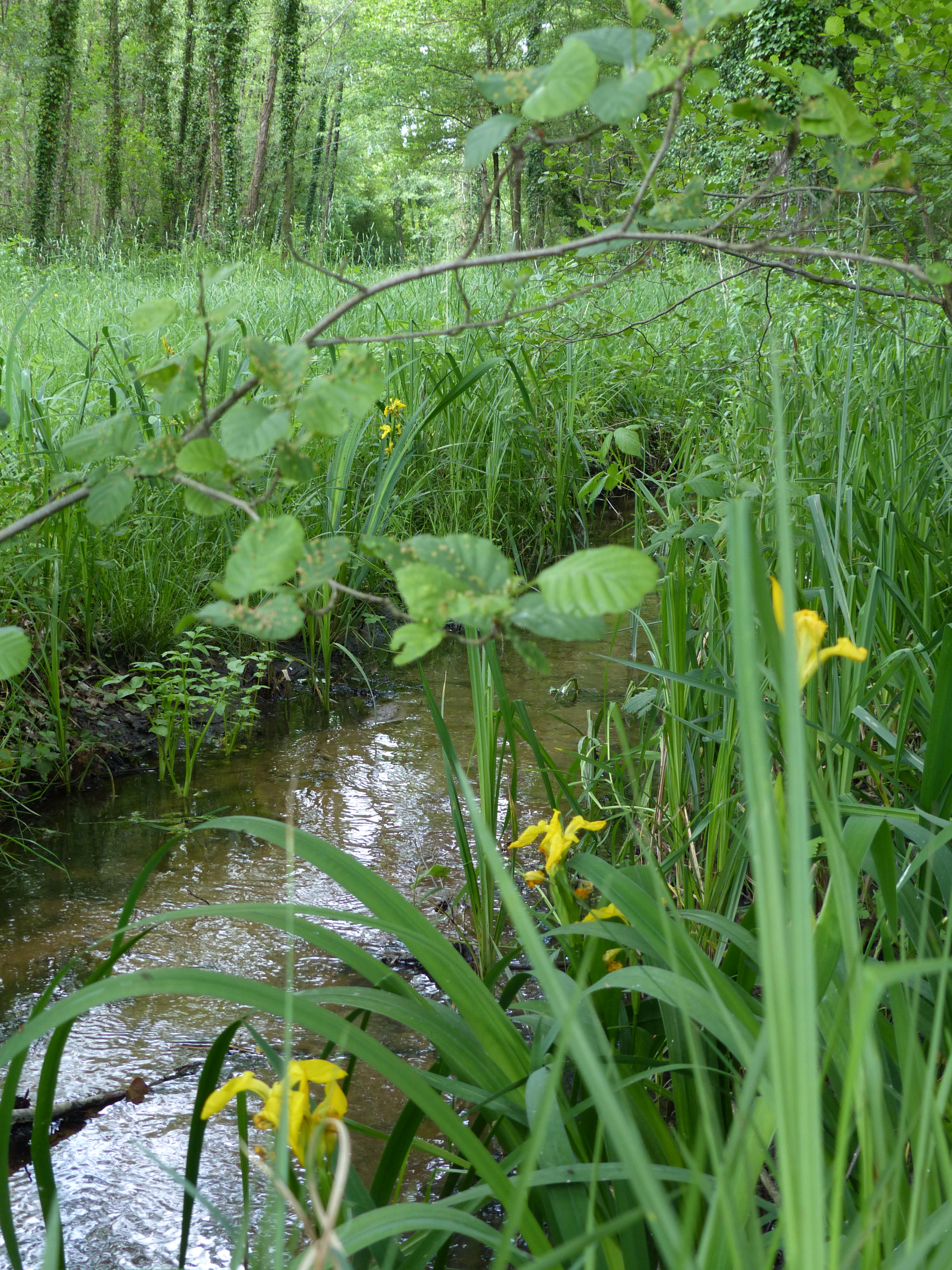
A small, narrow stream winds through lush green marshland, featuring yellow irises in the foreground and a dense forest background.
The Roule-Crottes stream flowing through the wetland environment of the reserve.

Réserve naturelle régionale du bas-marais tourbeux de la Basse-Goulandière history and protected-area timeline

The history of the Basse-Goulandière site begins well before its formal protection. The land has belonged to the commune of Parigné-l'Évêque since 1966, giving the local authority long-term control over how the peatland and its surrounding habitats would be managed.

In 1997 the commune entrusted conservation management to the Conservatoire d'espaces naturels of the Sarthe, beginning a phase of active ecological stewardship focused on maintaining the bas-marais. The site's first formal protection came on 18 December 2001, when it was recognised as a Réserve naturelle volontaire, a voluntary nature reserve status in use in France at that time. This early designation was short-lived: the 2002 'loi Démocratie de proximité' reorganised the French protected-area framework, and the voluntary reserve status was phased out in the early 2000s.

Recognition returned on 28 January 2011. Following a favourable opinion from the Conseil scientifique régional du patrimoine naturel, the Conseil régional of Pays de la Loire formally classed the bas-marais tourbeux de la Basse-Goulandière as a Réserve naturelle régionale. Today the reserve continues to be managed by the commune, with practical conservation work still carried out by the Sarthe Conservatoire d'espaces naturels, and the broader site forms part of the Natura 2000 network through Site of Community Importance FR5200647.

Réserve naturelle régionale du bas-marais tourbeux de la Basse-Goulandière landscape and geographic character

At a landscape scale, the Basse-Goulandière reserve occupies a quiet stretch of lowland Sarthe countryside, dominated by gentle slopes, woodland edges, and the shallow valley of the Roule-Crottes stream. The site lies southeast of Le Mans in a region otherwise shaped by mixed farming, hedgerows, and small forests, so the peatland reads as a distinctive, soft, waterlogged pocket within an otherwise cultivated rural matrix.

Within the reserve itself, the terrain is flat to gently undulating, with the mires occupying the lowest ground where groundwater emerges. Peat has built up slowly over time, supported by alkaline conditions that favour a particular set of plant communities. Around this wet core, the land rises slightly into drier zones: heathland with low shrubs and grasses, and woodland that frames the mire and helps regulate its water balance.

The Roule-Crottes stream runs along or near the reserve, acting as both a hydrological feeder and a physical boundary. The interplay between the slow-moving stream, the seepage zones at the mire's edge, and the surrounding drier slopes gives the site its characteristic pattern of saturated ground interspersed with firm, walkable paths. Forest tracks along the eastern side of the reserve let visitors move through this landscape without crossing the most fragile peatland areas.

Réserve naturelle régionale du bas-marais tourbeux de la Basse-Goulandière ecosystems, habitats, and plant life

The reserve is built around an alkaline lowland peatland, a habitat type that has become rare across western France as wetlands have been drained for agriculture. This bas-marais alcalin is the ecological backbone of the site, with peat-forming vegetation, saturated soils, and conditions that support a distinctive community of wetland plants.

Around the mire, the reserve gathers a mosaic of complementary habitats. There are wetter peripheral zones of marsh and meadow, drier heathland with low-growing shrubs, and patches of woodland that create shaded margins. This alternation of wet and dry, open and shaded environments is what allows the reserve to support a relatively diverse flora and fauna within a small surface area.

The bas-marais also plays an important hydrological role. By retaining and slowly releasing water, the peatland acts as a natural filter and storage system for the surrounding landscape, helping regulate the flow and quality of water moving toward the Roule-Crottes stream. This combination of biodiversity value and landscape-level water function is what gives the reserve its broader ecological significance beyond its 38 hectares.

Réserve naturelle régionale du bas-marais tourbeux de la Basse-Goulandière wildlife and species highlights

Wildlife at Basse-Goulandière reflects the unusual richness of habitat packed into a small area. The reserve hosts twelve nationally protected animal species, including the Agrion de Mercure, a rare damselfly tied to clean, well-vegetated streams, and the Triton crêté, the great crested newt, which depends on the network of pools, ditches, and wet hollows that the bas-marais provides.

The invertebrate fauna is particularly notable. The site supports thirty-nine species of day-flying butterflies and twenty-five species of odonates, the dragonflies and damselflies that thrive around the open water and saturated margins of the peatland. Together these groups are a strong indicator of habitat quality, since many of the species recorded are sensitive to disturbance, pollution, and changes in water levels.

Bats are another highlight. Eleven bat species have been recorded on the site, including four that are considered threatened. For a reserve of just 38 hectares, this bat diversity reflects the value of having woodland edges, open wetland, and insect-rich habitats all within easy commuting distance. The combination of rare invertebrates, protected amphibians, and a rich bat community makes the reserve a significant local stronghold of lowland wetland wildlife.

Réserve naturelle régionale du bas-marais tourbeux de la Basse-Goulandière conservation status and protection priorities

The reserve's conservation value lies in the fact that it protects one of the few surviving alkaline lowland peatlands in the Sarthe. Such habitats have been heavily reduced across north-western France, and the sites that remain are now disproportionately important for the species and ecological processes they sustain. By keeping the bas-marais intact and buffering it with surrounding heathland and woodland, the reserve preserves not only the mire itself but the hydrological and ecological conditions on which it depends.

At a wider scale, the reserve is integrated into the Natura 2000 network through Site of Community Importance FR5200647, which links the Narais valley, the Bercé forest, and the Dinan stream into a single ecological unit. This connection means that Basse-Goulandière is not an isolated patch but a node within a broader landscape of protected and ecologically valuable areas in the Sarthe.

The day-to-day management is what keeps this conservation value alive on the ground. The commune of Parigné-l'Évêque remains the formal administrator of the reserve, while the Sarthe Conservatoire d'espaces naturels carries out practical habitat work, a partnership that has been in place since 1997, well before the 2011 regional classification.

Réserve naturelle régionale du bas-marais tourbeux de la Basse-Goulandière cultural meaning and human context

The cultural context of the Basse-Goulandière reserve is closely tied to its communal history. The land has belonged to the commune of Parigné-l'Évêque since 1966, and the reserve has long been a site of local ecological awareness rather than tourism. Its designation reflects a regional and local decision to preserve a distinctive wetland landscape that might otherwise have been lost to agricultural change.

Within the wider Sarthe, the reserve sits in a rural landscape shaped by farming, small forests, and small valleys like that of the Roule-Crottes. The peatland has historically been a marginal area for farming, which is part of why it survived at all, and today it represents a piece of the region's environmental heritage that is managed for biodiversity, water quality, and quiet public discovery rather than for production.

Top sights and standout views in Réserve naturelle régionale du bas-marais tourbeux de la Basse-Goulandière

The reserve concentrates several qualities that are uncommon together in such a small area: an alkaline lowland peatland, a mosaic of wet and dry habitats, seven nationally protected plant species, and a rich protected fauna including rare dragonflies, the great crested newt, and eleven bat species.

Its location within the larger FR5200647 Site of Community Importance, and its long-standing management partnership between the commune of Parigné-l'Évêque and the Sarthe Conservatoire d'espaces naturels since 1997, give it both landscape-scale and institutional depth. The accessible forest paths on the eastern side of the site make this ecological richness approachable for on-site discovery.

Best time to visit Réserve naturelle régionale du bas-marais tourbeux de la Basse-Goulandière

As a wetland-focused reserve in the lowland Sarthe, Basse-Goulandière has an experiential dimension that shifts with the seasons. Spring and early summer bring the most active period for dragonflies, damselflies, and butterflies around the open water and saturated margins of the peatland, and are also when wetland plants are most visibly in flower.

Milder months outside of deep winter, when saturated ground and short days limit both visibility and accessibility, generally offer the richest combination of pleasant walking conditions and active wildlife. Summer visits showcase the green fullness of the surrounding woodland and heath, while autumn tends to bring out the textures of the mire and quieter, more contemplative conditions. Visitors should be aware that the most fragile peatland areas are not crossed by paths, so observation is concentrated along the marked routes.
Monthly climate preview

Long-term representative monthly temperature and precipitation patterns across the protected terrain

Climate Normals and Average Temperatures for Réserve naturelle régionale du bas-marais tourbeux de la Basse-Goulandière

Representative coordinates record measured monthly temperature ranges and precipitation averages spanning twelve distinct periods across the protected landscape. Examining the full climate profile provides deeper context for long-term meteorological normals without relying on short-term forecasts.
Annual mean11 °C
4 °C20 °C
Jan
Feb
Mar
Apr10°
May14°
Jun17°
Jul20°
Aug20°
Sep16°
Oct12°
Nov
Dec
Warmest month
August

19.7 °C

Coolest month
January

3.5 °C

Wettest month
December

2.5 mm/day

Driest month
August

1.6 mm/day

Park location guide

Geography guide, regional context, and park location map for Réserve naturelle régionale du bas-marais tourbeux de la Basse-Goulandière

Réserve naturelle régionale du bas-marais tourbeux de la Basse-Goulandière park geography, regions, and map view in France

Understand where Réserve naturelle régionale du bas-marais tourbeux de la Basse-Goulandière sits in France through a broader geographic reading of the surrounding landscape, nearby location context, and its mapped position within the national park landscape.

How Réserve naturelle régionale du bas-marais tourbeux de la Basse-Goulandière fits into France

France is a unitary semi-presidential republic and one of the world's largest economies. It borders Belgium, Luxembourg, Germany, Switzerland, Italy, Monaco, Andorra, and Spain, with a maritime border to the United Kingdom. The country is known for its cultural influence, art, cuisine, and political history spanning centuries.

Wider geography shaping Réserve naturelle régionale du bas-marais tourbeux de la Basse-Goulandière in France

France is located in Western Europe. Metropolitan France extends from the Rhine to the Atlantic Ocean and from the Mediterranean Sea to the English Channel and North Sea. The country borders Belgium, Luxembourg, Germany, Switzerland, Italy, Monaco, Andorra, Spain, and has a maritime border with the United Kingdom.

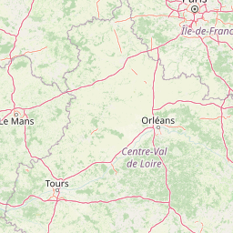
Map view of Réserve naturelle régionale du bas-marais tourbeux de la Basse-Goulandière

Use this park location map to pinpoint Réserve naturelle régionale du bas-marais tourbeux de la Basse-Goulandière in France, understand its exact geographic position, and read its mapped placement within the surrounding landscape more clearly.

Pigeon | © OpenStreetMap contributors

Location context for Réserve naturelle régionale du bas-marais tourbeux de la Basse-Goulandière

Pays de la Loire

Visual exploration of alkaline lowland peatlands, wet habitats, and woodland borders in Sarthe

Réserve naturelle régionale du bas-marais tourbeux de la Basse-Goulandière Photos and Scenery

Browse detailed photography showcasing the rare alkaline peat mires, marshlands, and woodland mosaics of Réserve naturelle régionale du bas-marais tourbeux de la Basse-Goulandière. Visual records reveal the distinct terrain, vegetation patterns, and protected wetland character of this western French nature reserve.

A small, narrow stream winds through lush green marshland, featuring yellow irises in the foreground and a dense forest background.

Park atlas

Compare adjacent wetland reserves and regional conservation landscapes across the surrounding Sarthe countryside

Other Protected Areas Near Réserve naturelle régionale du bas-marais tourbeux de la Basse-Goulandière

Browsing other protected areas near Réserve naturelle régionale du bas-marais tourbeux de la Basse-Goulandière reveals wider ecological networks and varied lowland terrain. Comparing regional reserves and surrounding lowland habitats provides deeper context for wetland conservation across western France.
Nature reservePays de la Loire
About 30 km away#1 closest

South

Réserve naturelle régionale des prairies et roselière des Dureaux: Loir Valley Protected Landscapes

Regional Nature Reserve in Pays de la Loire, France

Spanning the alluvial plains near Vaas, this reserve protects essential wet meadows and reedbed communities shaped by the seasonal rhythm of the Loir River. The landscape features a classic bocage character, offering a distinct example of wetland conservation within the Pays de la Loire region.

Area
0.253 km²
Established
2001
IUCN
IV
Relief
Lowland
Nature reservePays de la Loire
About 31 km away#2 closest

Southwest

Réserve naturelle régionale du coteau et prairies des Caforts: Protected Area and Map Atlas

A diverse protected landscape in the Pays de la Loire region

Situated in the Loir valley, this regional nature reserve combines three distinct landscape types: dry limestone slopes, humid hay meadows, and 910 meters of man-made tuffeau quarry galleries. The site represents a significant pocket of biodiversity, hosting sixteen bat species and rare flora within its compact protected footprint in Sarthe.

Area
0.064 km²
Established
2009
IUCN
IV
Nature reservePays de la Loire
About 46 km away#3 closest

Southwest

Réserve naturelle régionale des marais de Cré-sur-Loir et La Flèche Protected Landscape

Wetland ecosystems in the Pays de la Loire region.

Spanning an old meander of the Loir river, this regional nature reserve preserves a complex network of marshes, canals, and alluvial forests. Learn about its unique floodplain geography and the protected wetland habitats that sustain regional biodiversity in the heart of the Sarthe department.

Area
0.531 km²
Established
2008
IUCN
IV
Relief
Lowland
A watercolor painting showing a soft, pastoral landscape with green rolling hills, light yellow grasslands, and a tranquil pond in the foreground against a light, hazy sky.
Nature reservePays de la Loire
About 48 km away#4 closest

North

Réserve naturelle régionale du coteau et plateau de Tessé: Protected Limestone Geography

Calcareous grassland landscapes in the Sarthe department

Examine the geography of this regional nature reserve in Pays de la Loire. The site preserves a compact parcel of limestone plateau and slopes, offering a concentrated look at dry calcareous habitat conservation and the distinct geology of the Rutin valley area.

Area
0.056 km²
Established
2009
IUCN
IV
Relief
Upland
A watercolor illustration of a soft, rolling landscape with green hills, a winding path or stream, and hints of pink flora in the foreground, set against a light background.
Nature reservePays de la Loire
About 68 km away#5 closest

Northwest

Réserve naturelle régionale des landes et tourbière des Égoutelles Geographic Overview

Protected peat bog and wet heathland in Pays de la Loire

Located in Villepail, this nature reserve occupies a sheltered quarry depression in the Mayenne countryside. The site is a study in ecological resilience, featuring approximately one hundred plant species and a diverse fauna of dragonflies and amphibians that thrive in this compact, waterlogged habitat.

Area
0.013 km²
Established
2009
IUCN
IV
Relief
Lowland
A pale watercolor landscape painting showing rolling green hills and distant mountain ridgelines against a white background.
Nature reservePays de la Loire
About 69 km away#6 closest

Northwest

Réserve naturelle régionale Mont des Avaloirs: Protected Landscape and Geographic Overview

Upland heath and summit geography of the Armorican Massif

Investigate the unique physical geography of Réserve naturelle régionale Mont des Avaloirs. This area acts as a biodiversity stronghold in northwestern France, defined by a dramatic interplay of stony blockfields, sheltered valley brooks, and protected peatland basins that create atypical ecological conditions across the Mayenne countryside.

Area
3.211 km²
Established
2020
IUCN
IV
Relief
Mountain
Nature reserveFrance
About 76 km away#7 closest

North

Réserve naturelle régionale géologique de Normandie-Maine: Geological Nature Reserve

A protected Ordovician limestone site in the Armorican Massif

Located in northwestern France, this reserve focuses on the geological preservation of the Carrière des Vaux. It is an essential site for understanding Paleozoic biostratigraphy, featuring well-exposed limestone sequences and significant microfossil deposits that allow for precise dating of regional strata within the Normandie-Maine landscape.

Area
0.006 km²
Established
2009
Relief
Lowland
Climate
Temperate
A soft watercolor illustration featuring a calm pond in the foreground, with reeds on the right and a distant treeline and rolling hills in the background.
Nature reservePays de la Loire
About 79 km away#8 closest

Southwest

Réserve naturelle régionale des étang et boisements de Joreau: Protected Area Atlas Profile

Wetland and woodland mosaic in the Pays de la Loire region.

This profile examines the 92-hectare Réserve naturelle régionale des étang et boisements de Joreau, a protected area in the Maine-et-Loire department. The site features a specialized composition of freshwater ponds and mature woodlands, reflecting the traditional riverine landscapes found throughout the broader Loire Valley regional geography.

Area
0.92 km²
Established
2015
IUCN
IV

Common questions about visiting, size, designation, and location context for Réserve naturelle régionale du bas-marais tourbeux de la Basse-Goulandière

Réserve naturelle régionale du bas-marais tourbeux de la Basse-Goulandière FAQs for park facts, access, geography, and protected area context

Find quick answers about Réserve naturelle régionale du bas-marais tourbeux de la Basse-Goulandière, including protected-area facts, park geography, trail and visitor context, and how the park fits into its surrounding country and regional landscape.
MoriAtlas Explorer

Continue Your Protected Areas Search Across the Global Atlas

Deepen your exploration by continuing the structured search for national parks and protected areas worldwide. Utilize the comprehensive filtering capabilities to compare different conservation landscapes and refine your understanding of global park geography. Discover more about the distribution and characteristics of protected natural areas.

Global natural geography