Mori Atlas logo
Nature reserveRéserve naturelle régionale géologique de Normandie-Maine

Discover the stratigraphic importance and Paleozoic fossil record of this protected limestone quarry.

Réserve naturelle régionale géologique de Normandie-Maine: A Geological Protected Area in France

The Réserve naturelle régionale géologique de Normandie-Maine represents a vital protected landscape within France, centering on the scientifically significant Carrière des Vaux. This compact reserve serves as a critical reference point for Ordovician stratigraphy, providing researchers and observers with clear access to tilted limestone strata and preserved conodont microfossils that define the regional geological heritage of the Armorican Massif.

geological reserveOrdovician limestoneconodont fossilsArmorican Massifabandoned quarryregional nature reserve

Réserve naturelle régionale géologique de Normandie-Maine

Nature reserve

Park overview

Structured park overview, official facts, and landscape profile for Normandie-Maine Regional Geological Nature Reserve

Normandie-Maine Regional Geological Nature Reserve park facts, protected area profile, and essential visitor context

Review the core facts for Normandie-Maine Regional Geological Nature Reserve, including designation, size, terrain, visitor scale, habitats, and operating context in one park-focused overview.

About Normandie-Maine Regional Geological Nature Reserve

The Normandie-Maine Regional Geological Nature Reserve is a compact but scientifically important protected area in northwestern France. It was established to preserve a small abandoned Ordovician limestone quarry at Saint-Hilaire-la-Gérard, in the Orne department, on the edge of the Armorican Massif. Although the reserve covers less than a hectare, its protection status reflects the high national value of its geological content rather than the size of the territory.

The defining feature of the reserve is the presence of abundant conodont microfossils within its limestone layers. Conodonts are tiny, tooth-shaped remains of an extinct group of marine animals that lived during the Paleozoic Era, and they are widely used by geologists as index fossils for dating sedimentary rocks. Their exceptional preservation at Carrière des Vaux has allowed precise biostratigraphic dating of the local Ordovician sequence and has made the site a reference locality for studying Ordovician strata of the Armorican Massif.

Administratively, the reserve is managed by the neighbouring Parc naturel régional Normandie-Maine, which acquired the land after the death of the former owner in 2008. The site's geological importance had been documented since the late nineteenth century through the work of geologist Alexandre Bigot, and its heritage value was formally recognized in the regional geological inventory of 2007. Today, part of the quarry is open to visitors, offering a rare opportunity to observe fossil-bearing limestone blocks in their original geological context.

Ecologically, the reserve is secondary to its geological purpose, but it does support a small woodland flora typical of the region, including around a hundred vascular plant species, alongside a modest fauna of mammals, birds, and insects. The reserve's true identity remains firmly geological: it exists to protect, study, and present a small but nationally significant slice of French Paleozoic history.

Quick facts and research context for Normandie-Maine Regional Geological Nature Reserve

The Normandie-Maine Regional Geological Nature Reserve is a protected geological site of national importance located in the Orne department of Normandy, France. Classified as a regional nature reserve on 18 December 2009, it initially covered 0.37 hectares and was later extended to 0.58 hectares on 23 September 2024, making it among the smallest reserves of its category in France.

The reserve protects an abandoned Ordovician limestone quarry known as the Carrière des Vaux, at an altitude of about 245 meters. Its significance is paleontological rather than ecological: the site is renowned for its micro-fossils of conodonts, which have enabled precise biostratigraphic dating. It sits within the territory of the Parc naturel régional Normandie-Maine and was originally included on the regional geological heritage inventory in 2007.

Protection and recognition

Review documented terrestrial protection scope and baseline recognition metrics for this protected area.

Protection Status and International Recognition for Réserve naturelle régionale géologique de Normandie-Maine

Examine the recorded terrestrial protection status and management framework assigned to Réserve naturelle régionale géologique de Normandie-Maine. Review structured database attributes to understand baseline conservation metrics and official territorial designations.

Protection details

Protection scope
Terrestrial
Transboundary protection
No
WDPA ID
555514357
Park context

Deeper park guide and search-rich context for Normandie-Maine Regional Geological Nature Reserve

Normandie-Maine Regional Geological Nature Reserve history, landscape, wildlife, and travel context

Explore Normandie-Maine Regional Geological Nature Reserve through its history, landscape character, ecosystems, wildlife, conservation priorities, cultural context, and seasonal travel timing in a structured park guide built for atlas discovery and search intent.

Why Normandie-Maine Regional Geological Nature Reserve stands out

The reserve is best known for its microfossils of conodonts preserved within Ordovician-age limestone, which have given the site national importance in biostratigraphy and Paleozoic geology. These tiny tooth-shaped fossils have allowed geologists to precisely date the layers of the Armorican Massif and to correlate them with other Ordovician sequences elsewhere in Europe. Beyond the fossils themselves, the reserve is also recognized for its geological context on the northern flank of the Sées syncline, where limestone strata dip at roughly 40 degrees southward. The combination of scientifically valuable fossils, well-exposed stratigraphy, and accessible outcrops in a small, well-managed site makes this reserve a notable reference point in French geological heritage.
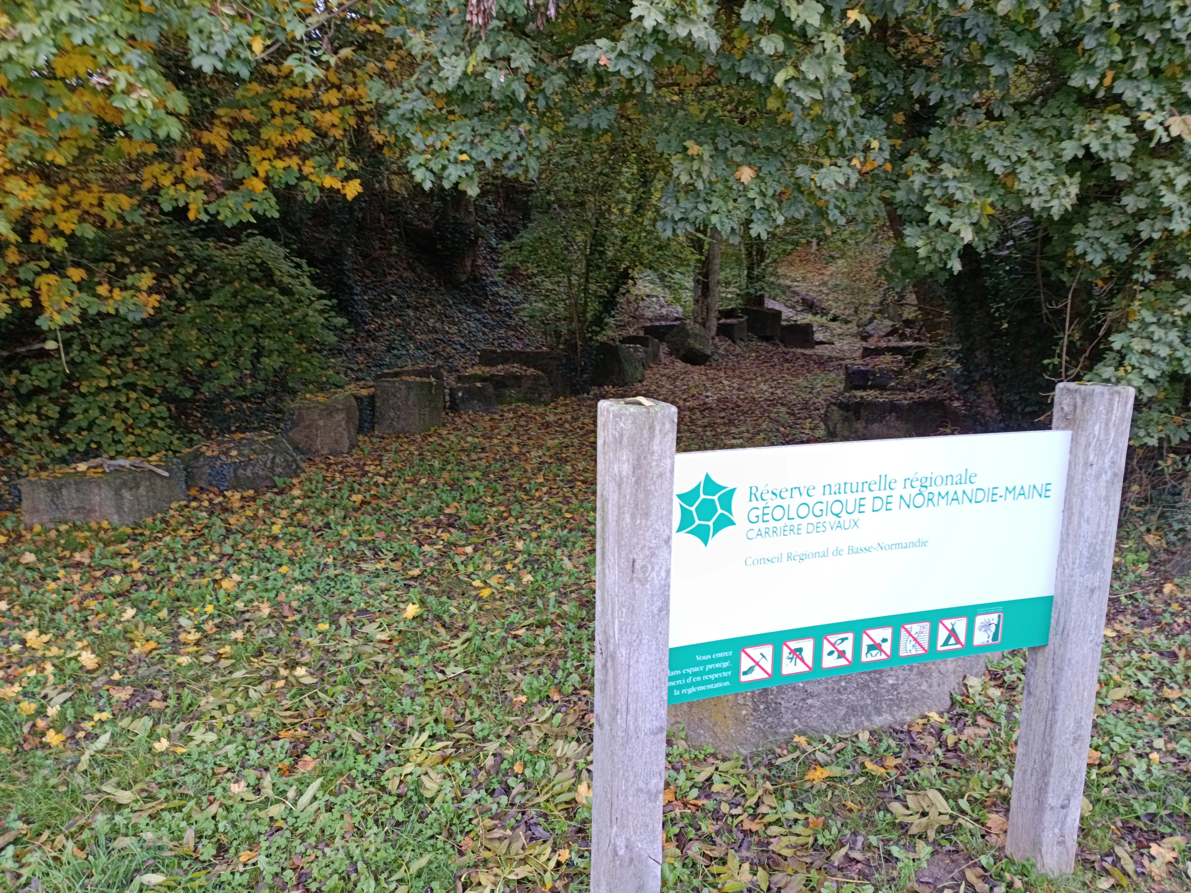
A white and green informational sign reading 'Réserve naturelle régionale géologique de Normandie-Maine Carrière des Vaux' with prohibition symbols, mounted on two wooden posts in a wooded area with autumn leaves on the ground and stone blocks visible in the background.
Entrance sign for the Carrière des Vaux site within the Réserve naturelle régionale géologique de Normandie-Maine, set against an autumn woodland backdrop with scattered stone blocks.

Normandie-Maine Regional Geological Nature Reserve history and protected-area timeline

The geological history of the site stretches back to the Ordovician Period, when the limestones now exposed in the Carrière des Vaux were deposited in a marine environment. Over hundreds of millions of years, these sediments became part of the bedrock of the eastern Armorican Massif, ultimately exposed on the northern flank of the Sées syncline with strata dipping southward at a steep angle.

The quarry itself became known to modern geology in the late nineteenth century through the work of the French geologist Alexandre Bigot, who studied the site for its stratigraphic significance. Limestone extraction continued into the early twentieth century before being abandoned, leaving the quarry as a natural geological exposure.

The reserve's modern history began with the inclusion of the site in the regional geological heritage inventory of 2007, which highlighted its paleontological value and prompted consideration of formal protections. The death of the site's private owner in 2008 allowed the Parc naturel régional Normandie-Maine to acquire the land, and on 18 December 2009 the quarry was officially classified as a regional nature reserve. A first management plan covered the period from 2012 to 2019, and on 23 September 2024 the reserve was extended to 0.58 hectares to strengthen protection of the geological heritage.

Normandie-Maine Regional Geological Nature Reserve landscape and geographic character

The physical setting of the reserve is modest in scale but visually distinctive. The protected area centers on the Carrière des Vaux, a small abandoned limestone quarry carved into a hillside at roughly 245 meters altitude. Surrounded by the rolling, wooded countryside characteristic of the eastern Armorican Massif, the quarry forms a compact open excavation framed by secondary woodland.

Geologically, the quarry exposes tilted Ordovician limestone strata on the northern flank of the Sées syncline. The bedding dips steeply southward at an average of around 40 degrees, giving the quarry walls a pronounced angled appearance. A network of fractures, or diaclases, runs through the limestone, encouraging controlled breakage into blocks; this is why the Carrière des Vaux historically produced usable building stone. The arrangement of strata and fractures gives the site a clean, readable geological exposure unusual for its size.

Normandie-Maine Regional Geological Nature Reserve ecosystems, habitats, and plant life

Although the reserve is designated primarily for its geological heritage, the surrounding environment supports a small wooded habitat typical of the Normandy countryside. About a hundred species of vascular plants have been recorded in and around the quarry, including species commonly associated with understory woodland.

Notable among these is the heart-leaved pear (Pyrus cordata), regarded as a rare species in the region, alongside other woodland plants such as wayfaring tree (Viburnum lantana), wood false brome (Brachypodium sylvaticum), remote sedge (Carex divulsa), Midland hawthorn (Crataegus laevigata), and the goat orchid (Himantoglossum hircinum). Together these species reflect the modest but characteristic biodiversity of a small limestone woodland clearing on the edge of the Armorican Massif.

Normandie-Maine Regional Geological Nature Reserve wildlife and species highlights

The reserve supports a limited but documented fauna consistent with its small, partly wooded footprint. Mammal records include five species using the site, while birdlife amounts to roughly twenty species, including woodland and edge-of-habitat birds typical of the Normandy bocage. Insect surveys have identified around thirty-four species, contributing to a modest but ecologically typical mosaic for an old quarry surrounded by secondary woodland.

Beyond these recorded counts, the reserve does not hold special status for its fauna. The relevant scale of wildlife here is local and contextual, serving more as a complement to the geological interest than as a standalone draw for biodiversity seekers.

Normandie-Maine Regional Geological Nature Reserve conservation status and protection priorities

The conservation value of the reserve is overwhelmingly geological rather than ecological. Its core purpose is to protect one of the most important Ordovician conodont-bearing limestone localities in France, a reference site for biostratigraphic research and for the study of the Paleozoic history of the Armorican Massif. Without formal protection, exposures like the Carrière des Vaux could be lost to weathering, vegetation overgrowth, or unauthorized collecting.

By classifying the site as a regional nature reserve in 2009, then extending it in 2024, the local and regional authorities have created a durable legal framework for preserving the fossil-bearing strata and managing access. The site's proximity to the Natura 2000 area "Haute vallée de l'Orne et affluents" situates it within a broader regional landscape that already benefits from coordinated nature protection. In this sense, the reserve plays a targeted but meaningful role in safeguarding a small but irreplaceable piece of French geological heritage.

Top sights and standout views in Normandie-Maine Regional Geological Nature Reserve

At under a hectare, the Normandie-Maine Regional Geological Nature Reserve is an unusually compact protected area, yet it stands out nationally for the quality of its Ordovician limestone and the abundance of conodont microfossils it preserves. These microfossils are the reason the site holds classification as a regional nature reserve despite its size, and the reason it features prominently in French references to Paleozoic biostratigraphy.

The reserve also stands out for being integrated into the management framework of the larger Parc naturel régional Normandie-Maine, which owns the land and oversees conservation. The combination of an accessible geological outcrop, a working management plan, and direct public access to fossil-bearing blocks gives the site a strong educational dimension alongside its scientific role.
Monthly climate preview

Long-term representative coordinate measurements detailing the annual climate rhythm across twelve monthly records

Annual Temperature and Precipitation Normals for Réserve Naturelle Régionale Géologique de Normandie-Maine

Representative coordinate records for Réserve naturelle régionale géologique de Normandie-Maine show measured monthly temperature variations paired with stable daily precipitation averages from 1991 to 2020. Reviewing the full monthly climate normals provides complete insight into the long-term thermal rhythm recorded at this location.
Annual mean10 °C
4 °C18 °C
Jan
Feb
Mar
Apr
May13°
Jun16°
Jul18°
Aug18°
Sep15°
Oct11°
Nov
Dec
Warmest month
August

18.1 °C

Coolest month
January

3.5 °C

Wettest month
December

2.6 mm/day

Driest month
March

1.7 mm/day

Park location guide

Geography guide, regional context, and park location map for Normandie-Maine Regional Geological Nature Reserve

Normandie-Maine Regional Geological Nature Reserve park geography, regions, and map view in France

Understand where Normandie-Maine Regional Geological Nature Reserve sits in France through a broader geographic reading of the surrounding landscape, nearby location context, and its mapped position within the national park landscape.

How Normandie-Maine Regional Geological Nature Reserve fits into France

France is a unitary semi-presidential republic and one of the world's largest economies. It borders Belgium, Luxembourg, Germany, Switzerland, Italy, Monaco, Andorra, and Spain, with a maritime border to the United Kingdom. The country is known for its cultural influence, art, cuisine, and political history spanning centuries.

Wider geography shaping Normandie-Maine Regional Geological Nature Reserve in France

France is located in Western Europe. Metropolitan France extends from the Rhine to the Atlantic Ocean and from the Mediterranean Sea to the English Channel and North Sea. The country borders Belgium, Luxembourg, Germany, Switzerland, Italy, Monaco, Andorra, Spain, and has a maritime border with the United Kingdom.

Map view of Normandie-Maine Regional Geological Nature Reserve

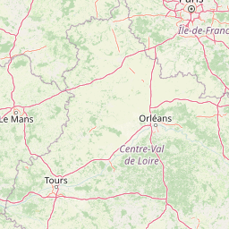
Use this park location map to pinpoint Normandie-Maine Regional Geological Nature Reserve in France, understand its exact geographic position, and read its mapped placement within the surrounding landscape more clearly.

Pigeon | © OpenStreetMap contributors

Visualizing the landscape, limestone quarry exposures, and wooded terrain of the protected area

Réserve naturelle régionale géologique de Normandie-Maine Photos and Scenery

Photographs document the exposed Ordovician limestone strata, angled rock formations, and surrounding wooded countryside defining the protected site. Visual reference material provides clear insight into the geological features, terrain characteristics, and regional landscape context.

A white and green informational sign reading 'Réserve naturelle régionale géologique de Normandie-Maine Carrière des Vaux' with prohibition symbols, mounted on two wooden posts in a wooded area with autumn leaves on the ground and stone blocks visible in the background.

Park atlas

Compare surrounding protected areas and connected geological reserves across the Armorican Massif

Parks Near Réserve naturelle régionale géologique de Normandie-Maine and Regional Protected Landscapes

Browsing other protected areas near Réserve naturelle régionale géologique de Normandie-Maine reveals broader regional terrain and connected geological formations. Comparing adjacent natural reserves helps place local stratigraphic formations within the wider conservation landscape of northwestern France.
A pale watercolor landscape painting showing rolling green hills and distant mountain ridgelines against a white background.
Nature reservePays de la Loire
About 21 km away#1 closest

Southwest

Réserve naturelle régionale Mont des Avaloirs: Protected Landscape and Geographic Overview

Upland heath and summit geography of the Armorican Massif

Investigate the unique physical geography of Réserve naturelle régionale Mont des Avaloirs. This area acts as a biodiversity stronghold in northwestern France, defined by a dramatic interplay of stony blockfields, sheltered valley brooks, and protected peatland basins that create atypical ecological conditions across the Mayenne countryside.

Area
3.211 km²
Established
2020
IUCN
IV
Relief
Mountain
A watercolor illustration of a soft, rolling landscape with green hills, a winding path or stream, and hints of pink flora in the foreground, set against a light background.
Nature reservePays de la Loire
About 32 km away#2 closest

Southwest

Réserve naturelle régionale des landes et tourbière des Égoutelles Geographic Overview

Protected peat bog and wet heathland in Pays de la Loire

Located in Villepail, this nature reserve occupies a sheltered quarry depression in the Mayenne countryside. The site is a study in ecological resilience, featuring approximately one hundred plant species and a diverse fauna of dragonflies and amphibians that thrive in this compact, waterlogged habitat.

Area
0.013 km²
Established
2009
IUCN
IV
Relief
Lowland
A watercolor painting showing a soft, pastoral landscape with green rolling hills, light yellow grasslands, and a tranquil pond in the foreground against a light, hazy sky.
Nature reservePays de la Loire
About 32 km away#3 closest

Southeast

Réserve naturelle régionale du coteau et plateau de Tessé: Protected Limestone Geography

Calcareous grassland landscapes in the Sarthe department

Examine the geography of this regional nature reserve in Pays de la Loire. The site preserves a compact parcel of limestone plateau and slopes, offering a concentrated look at dry calcareous habitat conservation and the distinct geology of the Rutin valley area.

Area
0.056 km²
Established
2009
IUCN
IV
Relief
Upland
A horizontal watercolor painting depicting a soft-toned landscape with a rocky scree slope in the foreground and rolling hills under a pastel sunset sky.
Nature reserveNormandie
About 34 km away#4 closest

West

Réserve naturelle régionale des pierriers de Normandie: Geographic Scree Slope Atlas

Examining rocky protected terrain in Normandy, France

The Réserve naturelle régionale des pierriers de Normandie protects one of the most distinctive natural scree slopes in northwestern Europe. This site preserves fragile rocky debris fields that support specialized vegetation and invertebrate communities. Our atlas data offers a close look at the boundaries and geological character of this significant protected landscape in the Orne department.

Area
0.009 km²
Established
2018
IUCN
IV
Scope
Terrestrial
Nature reserveNormandie
About 43 km away#5 closest

East

Réserve naturelle régionale de la clairière forestière de Bresolettes: Normandy Protected Landscapes

Mapping forest ecosystems and historic industrial water features in the Perche region.

Spanning roughly 780 hectares, this regional nature reserve serves as a vital biodiversity refuge in northwestern France. The landscape integrates mature woodland, wet meadows, and mire ecosystems that support rare flora and specialized fauna, offering a clear view of the complex environmental history of the Perche forest.

Area
7.8 km²
Established
2010
IUCN
IV
Watercolor painting of a river flowing through a valley with gentle green hills and trees on the banks.
Nature reserveCalvados
About 52 km away#6 closest

Northwest

Rochers des Parcs Nature Reserve: A Detailed Atlas and Protected Landscape Overview

Geographic boundaries and cliff terrain in Calvados, Normandy.

The Rochers des Parcs nature reserve features dramatic Cambrian conglomerate cliffs rising above the Orne river in the Calvados department. This site is defined by its steep wooded slopes, rare plant species, and established network of hiking paths. It represents a vital area of conservation, protected for its geological interest and ecological value, providing a clear window into the rugged terrain of the Suisse normande landscape.

Area
0.36 km²
Established
1977
Relief
Upland
Scope
Terrestrial
A watercolor painting showing a soft, stylized landscape with rolling green hills, small clusters of trees, and a winding waterway, with tall grass and flowers in the foreground.
Nature reservePays de la Loire
About 76 km away#7 closest

South

Réserve naturelle régionale du bas-marais tourbeux de la Basse-Goulandière: Regional Wetland Mapping

A rare alkaline lowland peatland within the Pays de la Loire administrative region

Examine the mapped terrain and habitat structure of this protected peatland near Le Mans. This site preserves an uncommon alkaline mire environment, serving as an essential ecological bridge within the Roule-Crottes stream valley and demonstrating the significant conservation value of small, high-quality wetland pockets in agricultural landscapes.

Area
0.38 km²
Established
2011
IUCN
IV
Nature reservePays de la Loire
About 78 km away#8 closest

Southwest

Réserve naturelle régionale des prairie et boisement humides des Bizeuls: Regional Nature Reserve Atlas

Wetland habitat preservation in the Mayenne department of western France.

This reserve provides a compact, ecologically dense mosaic of wet meadows and wet woodland in the Pays de la Loire region. It serves as a vital protected area for maintaining wetland biodiversity within a predominantly agricultural landscape, offering a precise look at the terrain and hydrological features characteristic of western France.

Area
0.044 km²
Established
2019
IUCN
IV

Common questions about visiting, size, designation, and location context for Normandie-Maine Regional Geological Nature Reserve

Normandie-Maine Regional Geological Nature Reserve FAQs for park facts, access, geography, and protected area context

Find quick answers about Normandie-Maine Regional Geological Nature Reserve, including protected-area facts, park geography, trail and visitor context, and how the park fits into its surrounding country and regional landscape.
MoriAtlas Explorer

Continue Your Protected Areas Search Across the Global Atlas

Deepen your exploration by continuing the structured search for national parks and protected areas worldwide. Utilize the comprehensive filtering capabilities to compare different conservation landscapes and refine your understanding of global park geography. Discover more about the distribution and characteristics of protected natural areas.

Global natural geography