
Mori Atlas logo
Nature reserveRéserve naturelle régionale des pierriers de Normandie

Mapping rare rocky debris slopes within the Orne department of western France

Réserve naturelle régionale des pierriers de Normandie: A Regional Protected Scree Landscape

The Réserve naturelle régionale des pierriers de Normandie represents a unique protected landscape in the Orne department, focused on the conservation of natural scree slopes. Covering a compact footprint within the wooded terrain of Normandy, this site provides critical habitat for specialized flora and invertebrate communities. Our data maps the rocky geometry of the pierriers, offering geographic context for these rare periglacial-style formations.

scree habitatrocky slopesregional nature reserveOrne departmentNormandysmall protected site
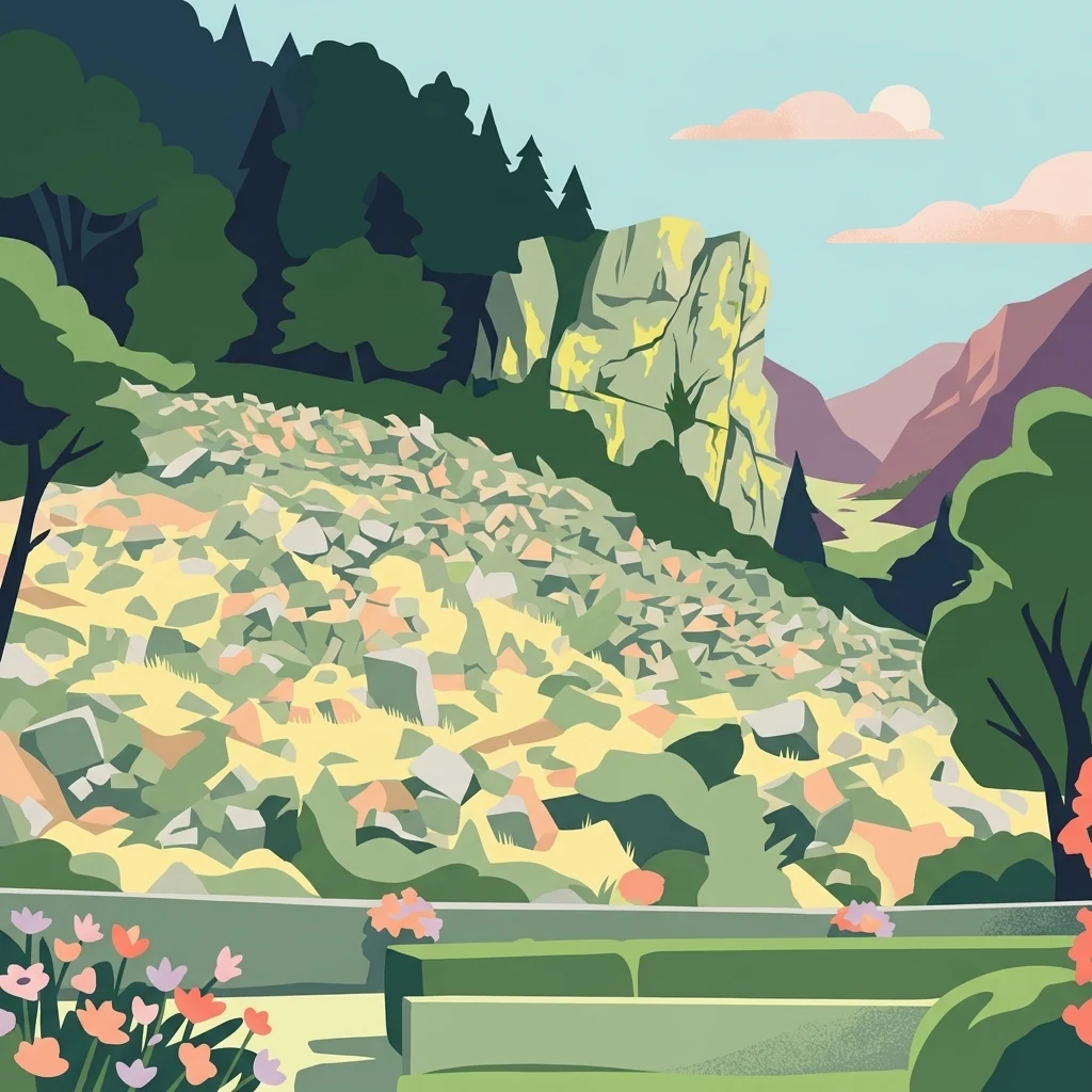
A stylized illustration showing a landscape with a large rocky scree slope, a prominent cliff formation, and surrounding forest under a soft sky.

Réserve naturelle régionale des pierriers de Normandie

Nature reserve

Park overview

Structured park overview, official facts, and landscape profile for Réserve naturelle régionale des pierriers de Normandie

Réserve naturelle régionale des pierriers de Normandie park facts, protected area profile, and essential visitor context

Review the core facts for Réserve naturelle régionale des pierriers de Normandie, including designation, size, terrain, visitor scale, habitats, and operating context in one park-focused overview.

About Réserve naturelle régionale des pierriers de Normandie

The Réserve naturelle régionale des pierriers de Normandie is a French regional nature reserve dedicated to the conservation of natural scree habitats, or pierriers, in the Orne department of Normandy. Although it is one of the smallest reserves of its kind in France, with a total area of less than a hectare, it addresses an outsized conservation concern by protecting a habitat type that is otherwise vanishingly rare in this part of Europe.

The reserve lies within the commune of Bagnoles de l'Orne Normandie, a region known for its forested valleys, gentle hills, and historic spa-town heritage. Within this broader landscape, the pierriers stand out as abrupt, rocky slopes that contrast sharply with the surrounding woodland. Their appearance is the result of long-term natural slope processes rather than quarrying or construction, and they form a distinctive kind of geological archive of the Normandy countryside.

What makes the reserve particularly notable is the way it bridges several conservation themes at once. It protects a geological landform of natural origin, the specialist plant communities that colonise stony debris, and the often-overlooked invertebrate fauna that depends on the shaded, moisture-retaining spaces between rocks. By formally recognising these values, the regional authority has highlighted how even very small sites can carry significant ecological and scientific weight.

The reserve also plays an educational and awareness-raising role, drawing attention to the broader category of rocky habitats in Normandy, including those outside protected boundaries. Because scree slopes are easily damaged by quarrying, trampling, or vegetation clearance, the site's protected status helps ensure that the fragile balance between rock, soil, and specialised life can continue undisturbed.

Quick facts and research context for Réserve naturelle régionale des pierriers de Normandie

The Réserve naturelle régionale des pierriers de Normandie is located in the Orne department of Normandy, in northwestern France, within the commune of Bagnoles de l'Orne Normandie. Created on 25 October 2018 by a deliberation of the Regional Council of Normandy, it is classified as a regional nature reserve under the French regional nature reserve framework and assigned IUCN Category IV as a habitat/species management area.

The site covers approximately 0.87 hectares, making it an exceptionally compact protected area. It is registered in the World Database on Protected Areas under the identifier 555639919 and is referenced in the French national inventory of protected natural heritage. Despite its small footprint, the reserve is recognised for protecting a rare and ecologically specific type of periglacial scree habitat, known locally as 'pierriers', which gives the reserve its name.

Protection and recognition

Documented terrestrial conservation framework and international registry records

Réserve naturelle régionale des pierriers de Normandie Protection Status

Terrestrial protection status for Réserve naturelle régionale des pierriers de Normandie is tracked through official registry records and designated database identifiers. Conservation scope and formal recognition metrics provide a structured baseline for protected area management.

Protection details

Protection scope
Terrestrial
WDPA ID
555639919
Park context

Deeper park guide and search-rich context for Réserve naturelle régionale des pierriers de Normandie

Réserve naturelle régionale des pierriers de Normandie history, landscape, wildlife, and travel context

Explore Réserve naturelle régionale des pierriers de Normandie through its history, landscape character, ecosystems, wildlife, conservation priorities, cultural context, and seasonal travel timing in a structured park guide built for atlas discovery and search intent.

Why Réserve naturelle régionale des pierriers de Normandie stands out

The reserve is best known for protecting one of the most distinctive natural scree slopes in Normandy. The featured site, illustrated historically by the pierrier du Roc au chien, is a rocky debris slope shaped by long-term geological processes rather than human activity. Such natural screes are uncommon in the low-elevation landscapes of northwestern France, where glacial and periglacial features are otherwise rare. Ecologically, the reserve stands out for the specialist flora and fauna that colonise unstable stony ground. These habitats support plant communities adapted to thin soils and high drainage, as well as invertebrates, lichens, and mosses that thrive in the cool, shaded microclimate found between rocks. The site therefore represents a living laboratory for understanding how life establishes itself on seemingly inhospitable terrain.
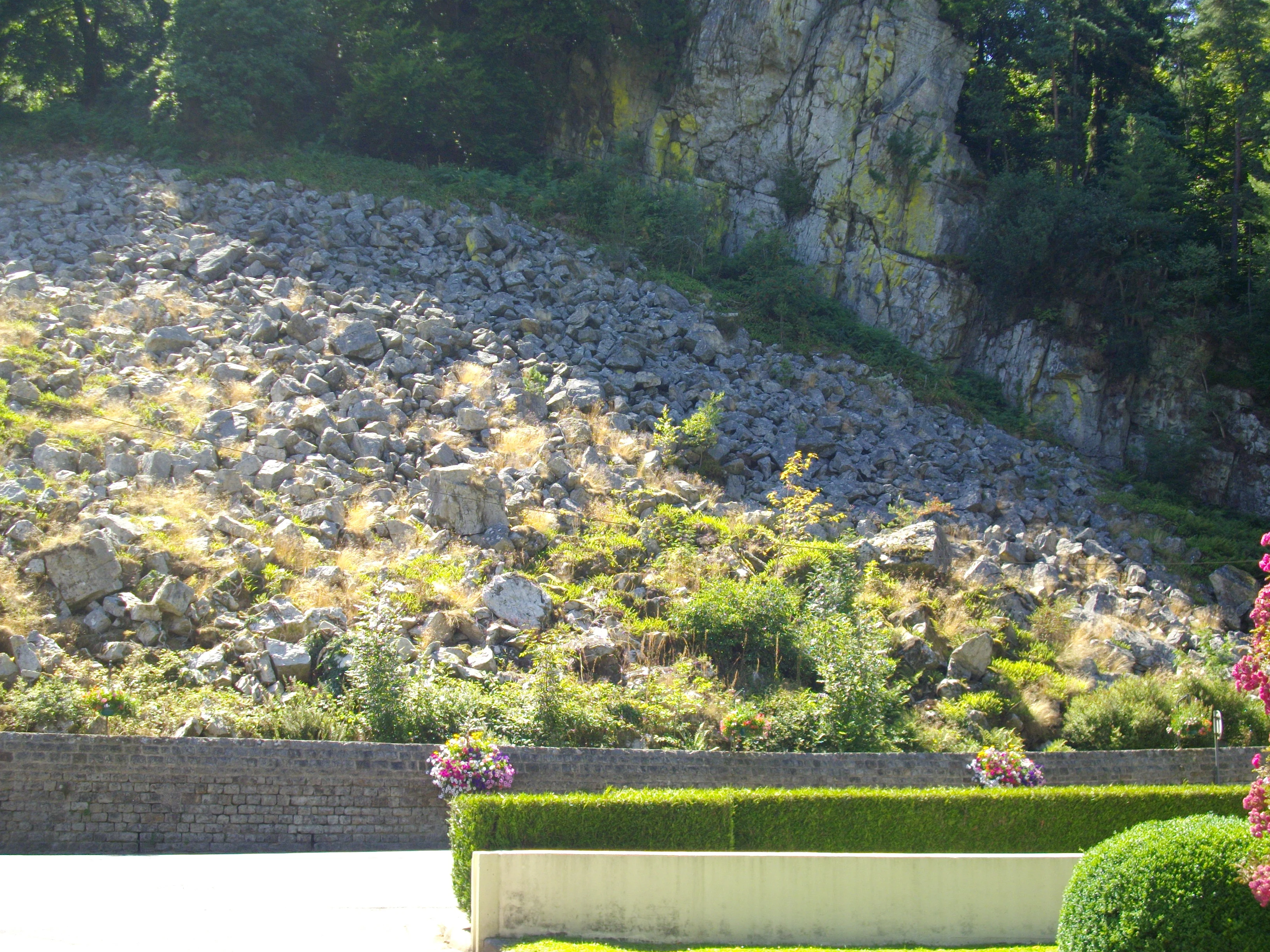
A steep, rocky scree slope sits beneath a large, craggy cliff face in a woodland setting, with a manicured hedge and flower pots in the foreground.
The Roc au Chien rock formation and scree slope in Bagnoles de l'Orne.

Réserve naturelle régionale des pierriers de Normandie history and protected-area timeline

The Réserve naturelle régionale des pierriers de Normandie was formally established on 25 October 2018, following a deliberation by the Regional Council of Normandy. Its creation reflects a growing regional interest in protecting small but ecologically distinctive sites that are not always captured by larger national protected-area frameworks.

The reserve emerged from local recognition that the natural scree slopes around Bagnoles de l'Orne Normandie were both geologically interesting and ecologically fragile, yet had no formal protection. By classifying the site as a regional nature reserve, the Normandy region placed it under the French system of regional nature reserves, which gives locally administered sites protected status while integrating them into national conservation databases. The reserve is now recorded in the World Database on Protected Areas and in the French national inventory of protected natural heritage.

Réserve naturelle régionale des pierriers de Normandie landscape and geographic character

The landscape of the reserve is dominated by its defining feature: natural scree slopes, the pierriers that give the site its name. These slopes are accumulations of rocky debris produced by the gradual weathering and movement of stone on hillsides, creating uneven, unstable terrain that contrasts with the surrounding wooded Normandy countryside.

The site illustrated historically by the pierrier du Roc au chien captures the classic character of these landforms: an exposed, sloping field of broken rock, sitting within a forest context and undisturbed by human excavation. The surrounding area, in the Orne department near Bagnoles de l'Orne Normandie, features the rolling, forested terrain typical of western Normandy, with mixed woodland, small valleys, and modest elevations.

The rocky surfaces themselves shape the visual identity of the site. Areas of shadow, lichen cover, moss patches, and small soil pockets form between the stones, creating a fine-grained mosaic that is striking within an otherwise soft, vegetated landscape. Although the reserve is very small, the contrast between rugged scree and adjacent forest gives it an outsize landscape presence.

Réserve naturelle régionale des pierriers de Normandie ecosystems, habitats, and plant life

The natural value of the Réserve naturelle régionale des pierriers de Normandie lies in its specialist habitat type. Scree slopes are environments defined more by stone than by soil, and the flora and fauna that occupy them are therefore highly specialised. Plants growing on the pierriers must cope with very thin or absent soils, high drainage, exposure to sun on open faces, and movement of the rocky substrate itself.

These conditions favour communities of lichens, mosses, and stress-adapted vascular plants, as well as invertebrates that take advantage of the cool, humid microclimate found deep within the debris. The combination of exposed rock surfaces and shaded crevices produces a finely structured microhabitat mosaic, in which different ecological niches occur within very short distances.

Although the reserve is tiny, the ecological processes it protects operate at the scale of individual stones and crevices. Slow weathering, soil formation, plant colonisation, and invertebrate colonisation can all be observed across the site. The reserve therefore offers a naturally compact laboratory for the study of rocky-habitat ecology in lowland northwestern Europe.

Réserve naturelle régionale des pierriers de Normandie wildlife and species highlights

The wildlife interest of the reserve centres on the invertebrate fauna and specialist organisms associated with natural scree habitats. Between and beneath the rocks, conditions remain relatively stable, humid, and sheltered, providing refuge for species that are poorly represented in open or heavily managed landscapes.

The reserve also supports populations of lichens and mosses that depend on the surface texture and shading of the stones themselves, as well as small fauna that move through the deeper layers of debris. These communities are typically inconspicuous and easily overlooked in larger landscapes, but they are a defining part of what makes pierrier habitats ecologically distinctive.

Although the reserve's small size limits the range of large vertebrates it can sustain, the site contributes to the broader ecological network of Normandy by protecting the often-hidden animal communities that depend on natural rocky ground.

Réserve naturelle régionale des pierriers de Normandie conservation status and protection priorities

The Réserve naturelle régionale des pierriers de Normandie is a conservation-focused site that targets a specific and easily overlooked habitat type. Its protected status under the French regional nature reserve framework ensures that the scree slopes within the reserve are shielded from quarrying, dumping, vegetation clearance, and other forms of direct disturbance that could damage the fragile surface structure of the debris.

Under IUCN Category IV, the reserve is recognised as a habitat and species management area, meaning that its purpose is to maintain particular ecological conditions rather than to set aside wilderness on a large scale. This makes it well suited to a small, ecologically specialised site such as the pierriers, where the goal is long-term preservation of a finely balanced ecosystem.

The reserve's conservation importance extends beyond its boundaries by raising awareness of scree habitats more generally in Normandy. By formally recognising the pierriers near Bagnoles de l'Orne Normandie, the reserve highlights the wider need to consider rocky habitats, even very small ones, as part of regional ecological heritage.

Réserve naturelle régionale des pierriers de Normandie cultural meaning and human context

The reserve lies within the commune of Bagnoles de l'Orne Normandie, an area long associated with the heritage of western Normandy, including its spa traditions and its mix of forest, hill, and rural landscape. The pierriers themselves form part of this regional identity, presenting the kind of unusual natural feature that local communities have historically noticed and discussed, even when they were not formally protected.

By giving the screes a protected status, the regional authority has effectively acknowledged them as part of the broader natural heritage of Normandy, alongside forests, rivers, and historic villages. This reflects a growing willingness within French regional conservation to recognise small, locally distinctive sites as carriers of both ecological and cultural value.

Top sights and standout views in Réserve naturelle régionale des pierriers de Normandie

Standout features of the reserve include the natural scree slope of the Roc au chien, the reserve's extremely compact 0.87-hectare footprint, and its rare-in-lowland-France status as a formally protected periglacial-style rocky habitat.

Best time to visit Réserve naturelle régionale des pierriers de Normandie

Because the reserve protects geological and ecological features rather than seasonal phenomena, its character changes relatively little across the year. However, late spring and early summer tend to be favourable periods for observing the reserve's ground-level biodiversity, when lichens, mosses, and specialist plants become more visible and the surrounding woodland is in full leaf.

Visiting in autumn can also be rewarding for those interested in the contrast between the bare scree surfaces and the colourful surrounding forest. Because the site involves uneven, rocky ground, dry conditions and good footwear make any on-site observation easier, regardless of season.
Monthly climate preview

Long-term representative point measurements tracking monthly temperature ranges and precipitation averages across the protected terrain

Climate Normals and Annual Temperature Patterns for Réserve naturelle régionale des pierriers de Normandie

Representative coordinate records show measured monthly temperature variations spanning from winter minimums to summer maximums alongside consistent daily precipitation levels. Reviewing these multi-year climate normals provides essential baseline context for the protected area without relying on short-term forecasts.
Annual mean10 °C
4 °C18 °C
Jan
Feb
Mar
Apr
May13°
Jun16°
Jul18°
Aug18°
Sep15°
Oct11°
Nov
Dec
Warmest month
July

17.7 °C

Coolest month
January

3.9 °C

Wettest month
December

2.7 mm/day

Driest month
March

1.7 mm/day

Park location guide

Geography guide, regional context, and park location map for Réserve naturelle régionale des pierriers de Normandie

Réserve naturelle régionale des pierriers de Normandie park geography, regions, and map view in France

Understand where Réserve naturelle régionale des pierriers de Normandie sits in France through a broader geographic reading of the surrounding landscape, nearby location context, and its mapped position within the national park landscape.

How Réserve naturelle régionale des pierriers de Normandie fits into France

France is a unitary semi-presidential republic and one of the world's largest economies. It borders Belgium, Luxembourg, Germany, Switzerland, Italy, Monaco, Andorra, and Spain, with a maritime border to the United Kingdom. The country is known for its cultural influence, art, cuisine, and political history spanning centuries.

Wider geography shaping Réserve naturelle régionale des pierriers de Normandie in France

France is located in Western Europe. Metropolitan France extends from the Rhine to the Atlantic Ocean and from the Mediterranean Sea to the English Channel and North Sea. The country borders Belgium, Luxembourg, Germany, Switzerland, Italy, Monaco, Andorra, Spain, and has a maritime border with the United Kingdom.

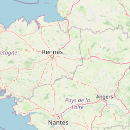
Map view of Réserve naturelle régionale des pierriers de Normandie

Use this park location map to pinpoint Réserve naturelle régionale des pierriers de Normandie in France, understand its exact geographic position, and read its mapped placement within the surrounding landscape more clearly.

Pigeon | © OpenStreetMap contributors

Location context for Réserve naturelle régionale des pierriers de Normandie

Normandie

Examine the rare scree slopes, rocky terrain, and protected habitats of Normandy

Visual Exploration of Réserve naturelle régionale des pierriers de Normandie Scenery

Visual records reveal the rugged terrain, natural scree slopes, and unique geological microclimates that define Réserve naturelle régionale des pierriers de Normandie. Detailed photography helps observers understand the rare stone formations and specialized habitats preserved within this protected regional landscape.

A steep, rocky scree slope sits beneath a large, craggy cliff face in a woodland setting, with a manicured hedge and flower pots in the foreground.

Park atlas

Compare surrounding regional nature reserves and protected landscapes across Normandy

Parks Near Réserve naturelle régionale des pierriers de Normandie and Regional Protected Areas

Browsing parks near Réserve naturelle régionale des pierriers de Normandie reveals broader geological formations and wooded regional protected areas across western France. Expanding the geographic comparison helps connect unique micro-habitats with wider regional conservation networks.
A watercolor illustration of a soft, rolling landscape with green hills, a winding path or stream, and hints of pink flora in the foreground, set against a light background.
Nature reservePays de la Loire
About 21 km away#1 closest

Southeast

Réserve naturelle régionale des landes et tourbière des Égoutelles Geographic Overview

Protected peat bog and wet heathland in Pays de la Loire

Located in Villepail, this nature reserve occupies a sheltered quarry depression in the Mayenne countryside. The site is a study in ecological resilience, featuring approximately one hundred plant species and a diverse fauna of dragonflies and amphibians that thrive in this compact, waterlogged habitat.

Area
0.013 km²
Established
2009
IUCN
IV
Relief
Lowland
A pale watercolor landscape painting showing rolling green hills and distant mountain ridgelines against a white background.
Nature reservePays de la Loire
About 22 km away#2 closest

Southeast

Réserve naturelle régionale Mont des Avaloirs: Protected Landscape and Geographic Overview

Upland heath and summit geography of the Armorican Massif

Investigate the unique physical geography of Réserve naturelle régionale Mont des Avaloirs. This area acts as a biodiversity stronghold in northwestern France, defined by a dramatic interplay of stony blockfields, sheltered valley brooks, and protected peatland basins that create atypical ecological conditions across the Mayenne countryside.

Area
3.211 km²
Established
2020
IUCN
IV
Relief
Mountain
Nature reserveFrance
About 34 km away#3 closest

East

Réserve naturelle régionale géologique de Normandie-Maine: Geological Nature Reserve

A protected Ordovician limestone site in the Armorican Massif

Located in northwestern France, this reserve focuses on the geological preservation of the Carrière des Vaux. It is an essential site for understanding Paleozoic biostratigraphy, featuring well-exposed limestone sequences and significant microfossil deposits that allow for precise dating of regional strata within the Normandie-Maine landscape.

Area
0.006 km²
Established
2009
Relief
Lowland
Climate
Temperate
Watercolor painting of a river flowing through a valley with gentle green hills and trees on the banks.
Nature reserveCalvados
About 40 km away#4 closest

North

Rochers des Parcs Nature Reserve: A Detailed Atlas and Protected Landscape Overview

Geographic boundaries and cliff terrain in Calvados, Normandy.

The Rochers des Parcs nature reserve features dramatic Cambrian conglomerate cliffs rising above the Orne river in the Calvados department. This site is defined by its steep wooded slopes, rare plant species, and established network of hiking paths. It represents a vital area of conservation, protected for its geological interest and ecological value, providing a clear window into the rugged terrain of the Suisse normande landscape.

Area
0.36 km²
Established
1977
Relief
Upland
Scope
Terrestrial
Nature reservePays de la Loire
About 46 km away#5 closest

Southwest

Réserve naturelle régionale des prairie et boisement humides des Bizeuls: Regional Nature Reserve Atlas

Wetland habitat preservation in the Mayenne department of western France.

This reserve provides a compact, ecologically dense mosaic of wet meadows and wet woodland in the Pays de la Loire region. It serves as a vital protected area for maintaining wetland biodiversity within a predominantly agricultural landscape, offering a precise look at the terrain and hydrological features characteristic of western France.

Area
0.044 km²
Established
2019
IUCN
IV
A watercolor painting showing a soft, pastoral landscape with green rolling hills, light yellow grasslands, and a tranquil pond in the foreground against a light, hazy sky.
Nature reservePays de la Loire
About 59 km away#6 closest

East

Réserve naturelle régionale du coteau et plateau de Tessé: Protected Limestone Geography

Calcareous grassland landscapes in the Sarthe department

Examine the geography of this regional nature reserve in Pays de la Loire. The site preserves a compact parcel of limestone plateau and slopes, offering a concentrated look at dry calcareous habitat conservation and the distinct geology of the Rutin valley area.

Area
0.056 km²
Established
2009
IUCN
IV
Relief
Upland
Nature reserveNormandie
About 77 km away#7 closest

East

Réserve naturelle régionale de la clairière forestière de Bresolettes: Normandy Protected Landscapes

Mapping forest ecosystems and historic industrial water features in the Perche region.

Spanning roughly 780 hectares, this regional nature reserve serves as a vital biodiversity refuge in northwestern France. The landscape integrates mature woodland, wet meadows, and mire ecosystems that support rare flora and specialized fauna, offering a clear view of the complex environmental history of the Perche forest.

Area
7.8 km²
Established
2010
IUCN
IV
A minimalist watercolor painting of soft green hills and light patches of color against a plain white background.
Nature reserveNormandie
About 79 km away#8 closest

Northwest

Réserve naturelle nationale de la forêt domaniale de Cerisy: A Normandy Protected Area

Ecological landscape and forest geography in France

Situated across the Calvados and Manche departments, this nature reserve protects a substantial beech-dominated state forest. The site provides a unique opportunity to study woodland ecosystems, endemic beetle conservation, and the transition between dense forest interiors and the surrounding Norman bocage landscape.

Area
21.24 km²
Established
1976
IUCN
IV
Relief
Upland

Common questions about visiting, size, designation, and location context for Réserve naturelle régionale des pierriers de Normandie

Réserve naturelle régionale des pierriers de Normandie FAQs for park facts, access, geography, and protected area context

Find quick answers about Réserve naturelle régionale des pierriers de Normandie, including protected-area facts, park geography, trail and visitor context, and how the park fits into its surrounding country and regional landscape.
MoriAtlas Explorer

Continue Your Protected Areas Search Across the Global Atlas

Deepen your exploration by continuing the structured search for national parks and protected areas worldwide. Utilize the comprehensive filtering capabilities to compare different conservation landscapes and refine your understanding of global park geography. Discover more about the distribution and characteristics of protected natural areas.

Global natural geography