
Mori Atlas logo
Nature reserveRéserve naturelle régionale du coteau et plateau de Tessé

Mapping the calcareous grassland and plateau geography of this Sarthe nature reserve

Réserve naturelle régionale du coteau et plateau de Tessé: A Protected Limestone Landscape

The Réserve naturelle régionale du coteau et plateau de Tessé protects a distinctive limestone landscape in the Pays de la Loire region. This compact nature reserve encompasses rare calcareous grassland habitats shaped by underlying oolithic geology. Through our geographic records, examine the plateau and slope terrain that supports significant botanical and entomological diversity within the Sarthe department.

calcareous grasslandlimestone plateauprotected florainvertebrate diversitybutterfly habitatregional nature reserve
A stylized vector illustration of a waterfall flowing through a deep canyon with coniferous trees in the foreground and mountains in the distance.

Réserve naturelle régionale du coteau et plateau de Tessé

Nature reserve

Park overview

Structured park overview, official facts, and landscape profile for Réserve naturelle régionale du coteau et plateau de Tessé

Réserve naturelle régionale du coteau et plateau de Tessé park facts, protected area profile, and essential visitor context

Review the core facts for Réserve naturelle régionale du coteau et plateau de Tessé, including designation, size, terrain, visitor scale, habitats, and operating context in one park-focused overview.

About Réserve naturelle régionale du coteau et plateau de Tessé

The Réserve naturelle régionale du coteau et plateau de Tessé is a small but ecologically focused regional nature reserve in northwestern France. It lies in the Sarthe department of the Pays de la Loire region, on the commune of Villaines-la-Carelle, along the edge of the Rutin valley. The reserve protects a single parcel of roughly 5.57 hectares of calcareous plateau and slope habitat, at an altitude of approximately 140 metres.

The defining feature of the site is its exposed limestone geology. The rock, an oolithic limestone dating from the upper Bajocian stage, was historically quarried in a nearby pit. Because the shallow, rocky soil limits agricultural use, the slopes have long been left under pastoral management, which has favored the development of calcareous grassland rich in specialized plants and insects.

Classified on 14 December 2009 by a deliberation of the regional council, the reserve carries the code RNR214 and falls under IUCN Category IV (habitat/species management area). It is administered by the Conservatoire d'espaces naturels de la Sarthe, a regional body dedicated to the protection and management of natural sites. Public access to the reserve is permitted, in keeping with the site's educational and nature-discovery purpose. Although small, the reserve represents an important fragment of the dry calcareous habitat network of the Sarthe and forms part of a wider pattern of regional nature reserves across France.

The reserve stands out as an example of how very small protected areas can play an outsized role in the conservation of specific habitat types. Its botanical and entomological richness reflects the long-term interaction between geology, land use history, and the ecological dynamics of calcareous grasslands in western France.

Quick facts and research context for Réserve naturelle régionale du coteau et plateau de Tessé

The Réserve naturelle régionale du coteau et plateau de Tessé is a Category IV regional nature reserve in the Sarthe department of the Pays de la Loire region. Created by a deliberation of the regional council on 14 December 2009, it covers 5.57 hectares on a single parcel in the commune of Villaines-la-Carelle.

The reserve sits at around 140 metres of altitude on the edge of the Rutin valley. It is managed by the Conservatoire d'espaces naturels de la Sarthe and protects calcareous grassland growing on outcropping Bajocian-age oolithic limestone. The site is referenced in the World Database on Protected Areas under the identifier 555559577.

Protection and recognition

Documented terrestrial conservation scope and formal protected area metrics.

Réserve naturelle régionale du coteau et plateau de Tessé Protection Status

Terrestrial protection status records detail the formal management scope and administrative framework governing the landscape. Official database entries compile verified designation parameters without projecting specific conservation outcomes.

Protection details

Protection scope
Terrestrial
Transboundary protection
No
WDPA ID
555559577
Park context

Deeper park guide and search-rich context for Réserve naturelle régionale du coteau et plateau de Tessé

Réserve naturelle régionale du coteau et plateau de Tessé history, landscape, wildlife, and travel context

Explore Réserve naturelle régionale du coteau et plateau de Tessé through its history, landscape character, ecosystems, wildlife, conservation priorities, cultural context, and seasonal travel timing in a structured park guide built for atlas discovery and search intent.

Why Réserve naturelle régionale du coteau et plateau de Tessé stands out

The reserve is best known for its calcareous grassland habitat, shaped by the underlying oolithic limestone that limits cultivation and encourages pastoral activity. This combination has produced species-rich dry grassland with notable botanical and entomological diversity, including regionally protected plants and a rich butterfly fauna. The site is also recognized for its compact but ecologically focused character. Despite covering only a few hectares, it concentrates a meaningful variety of calcareous habitat specialists, from junipers and pulsatillas to rare blue butterflies and orthopterans, making it a valued local conservation site within the Sarthe.
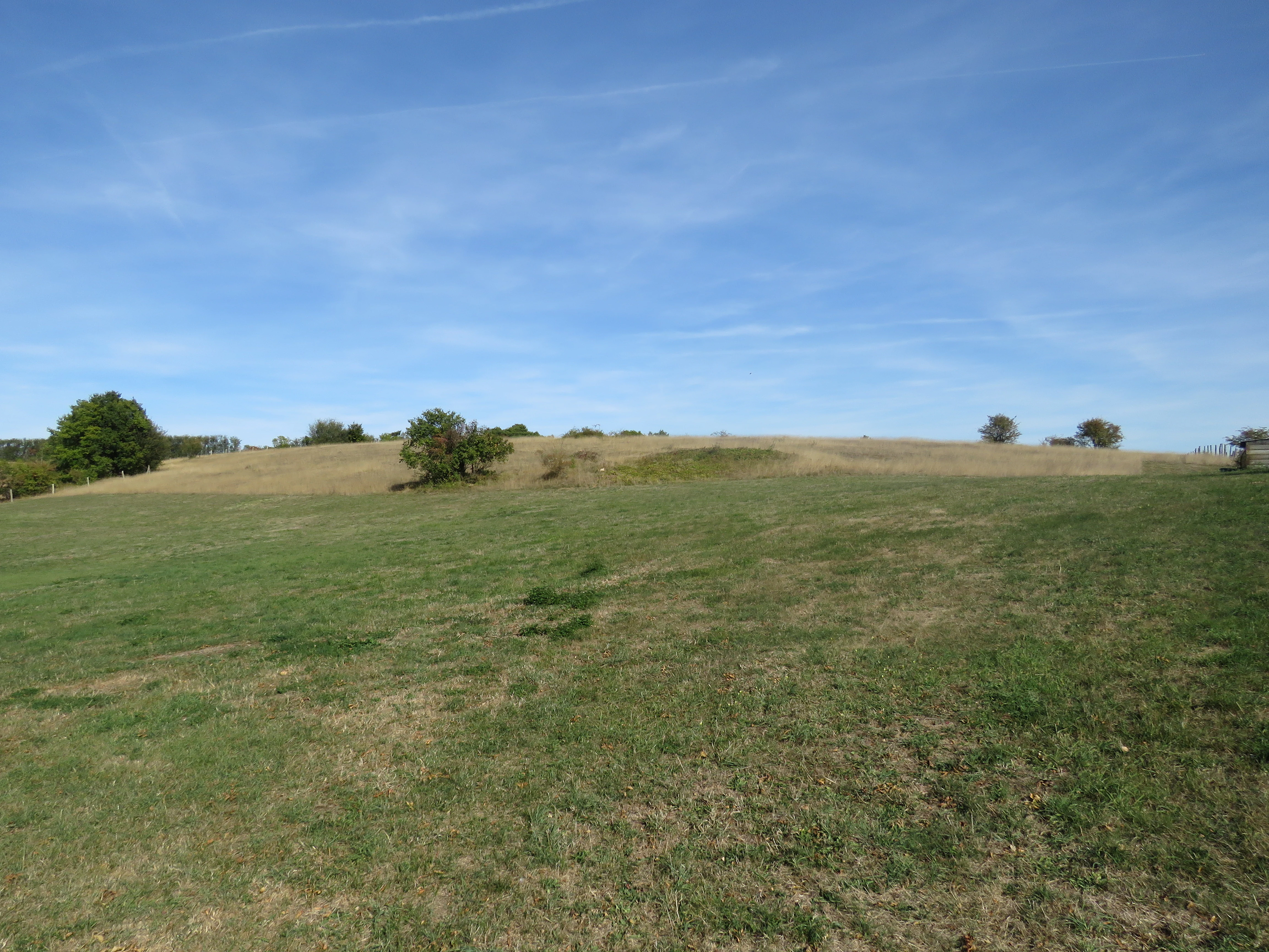
A wide, open landscape showing grassy meadows and plateaus under a clear blue sky, with a few scattered trees in the distance.
A view of the open grasslands and plateaus at Réserve naturelle régionale du coteau et plateau de Tessé.

Réserve naturelle régionale du coteau et plateau de Tessé history and protected-area timeline

The Réserve naturelle régionale du coteau et plateau de Tessé was officially classified on 14 December 2009 by the regional council of Pays de la Loire. The classification was established for an initial renewable period of six years and designated the reserve as RNR214 within the French regional nature reserve system.

The site's ecological value, however, predates its formal protection. The shallow, rocky limestone soils of the plateau have historically restricted cultivation and instead encouraged pastoral use, and the presence of a nearby former quarry reflects long-standing human awareness of the limestone substrate. The creation of the reserve by the Conservatoire d'espaces naturels de la Sarthe formalized the protection of a habitat that had already been maintained in a semi-natural state by traditional land use.

Réserve naturelle régionale du coteau et plateau de Tessé landscape and geographic character

The landscape of the reserve is shaped by its calcareous geology and its position along the Rutin valley. The terrain consists of a single parcel combining a plateau and a coteau, or limestone slope, at an altitude of about 140 metres. The underlying oolithic limestone of the upper Bajocian stage, deposited roughly 170 million years ago, outcrops across the slope, and was once exploited in a nearby quarry.

The thin, rocky soils derived from this limestone have prevented agricultural intensification and helped preserve a pastoral landscape of open calcareous grassland. Junipers, shrubs such as Bois de Sainte-Lucie, and herbaceous plants like Globulaire commune and Pulsatille vulgaire give the coteau a character typical of dry limestone habitats. The combination of plateau and slope creates a compact but varied micro-topography within a very small area, making the site especially valuable for the dry-habitat species it supports.

Réserve naturelle régionale du coteau et plateau de Tessé ecosystems, habitats, and plant life

Calcareous grassland is the defining ecological feature of the reserve. The exposed oolithic limestone limits soil development and creates the dry, nutrient-poor conditions that support a specialised flora. The reserve hosts more than 200 vascular plant species, including three regionally protected plants: Globulaire commune, Pulsatille vulgaire, and Petit pigamon. A further 24 species appear on the regional red list.

Beyond these highlights, the vegetation includes characteristic calcareous grassland species such as Bois de Sainte-Lucie, Genévrier commun, Céraiste des champs, and Polygale du calcaire. Juniper, in particular, contributes shrubby structure to the otherwise open landscape. Together, these elements create a dry, sun-exposed habitat community that contrasts with the surrounding woodland and agricultural land in the Rutin valley.

The reserve is officially a small, habitat-focused site designated under IUCN Category IV, a classification that emphasises active management of specific habitats and species rather than wilderness preservation.

Réserve naturelle régionale du coteau et plateau de Tessé wildlife and species highlights

The fauna documented at the reserve amounts to around 92 recorded species, overwhelmingly composed of insects. Orthopterans, or grasshoppers and related insects, are particularly well represented, with species recorded including the Gomphocère roux and the Criquet de la palène. The reserve's open, sun-exposed calcareous slopes provide ideal conditions for these warmth-loving invertebrates, which depend on the short grassland structure maintained by pastoral activity.

Butterflies are another highlight of the site's biodiversity, with 39 species recorded. Notable species present include the Zygène transalpine, the Azuré des cytises, the Argus bleu-nacré, the Argus bleu céleste, the Virgule, and the Mélitée des scabieuses. Together, these insects illustrate how a small calcareous site can sustain a rich and specialised invertebrate community.

Réserve naturelle régionale du coteau et plateau de Tessé conservation status and protection priorities

The reserve was created primarily to protect a fragment of calcareous grassland habitat in the Sarthe. By safeguarding the outcropping limestone, the associated dry soils, and the open pasture vegetation, it preserves conditions that support a high concentration of regionally protected plants and rare invertebrates within a very small footprint.

As a Category IV protected area under the IUCN framework, the reserve is managed with a focus on habitat and species conservation rather than strict wilderness preservation. The Conservatoire d'espaces naturels de la Sarthe oversees its management, ensuring that the traditional pastoral dynamic that maintains the grassland continues and that the botanical and entomological values documented for the site are preserved over successive six-year classification cycles.

Réserve naturelle régionale du coteau et plateau de Tessé cultural meaning and human context

The cultural context of the reserve is closely tied to the long-standing interaction between people and the limestone landscape of the Sarthe. Outcropping oolithic limestone once supported a local quarry, and the thin soils of the coteau and plateau have historically made cultivation impractical, encouraging pastoral land use.

This pastoral tradition has shaped the reserve's present-day character, since it is the combination of rocky terrain and grazing that has maintained the open calcareous grassland on which the reserve's biodiversity depends. The site thus reflects a regional heritage of working with, rather than against, the limitations of limestone terrain in northwestern France.

Top sights and standout views in Réserve naturelle régionale du coteau et plateau de Tessé

The Réserve naturelle régionale du coteau et plateau de Tessé stands out as a compact yet species-rich calcareous habitat in the Sarthe. Five and a half hectares of plateau and slope protect more than 200 plant species, including three regionally protected plants and 24 red-list species, alongside 39 butterfly species and a notable community of orthopterans.

The reserve's tight focus on a single habitat type, dry limestone grassland, makes it an unusually concentrated example of calcareous habitat conservation in the Pays de la Loire. Its small size and accessible location, combined with its IUCN Category IV status and management by the Conservatoire d'espaces naturels de la Sarthe, make it a useful local reference site for understanding how small protected areas can play important roles in regional biodiversity conservation.

Best time to visit Réserve naturelle régionale du coteau et plateau de Tessé

Calcareous grasslands such as this one are at their most vivid in late spring and summer, when the flowering of characteristic limestone plants such as Globulaire commune, Pulsatille vulgaire, and Polygale du calcaire brings colour to the slope. Warm, sunny conditions during this period also support peak activity among butterflies and orthopterans, making the warmer months the most rewarding time to observe the site's botanical and entomological richness. Visitors should note that public access is permitted under the reserve's regulations, and visits should respect the delicate grassland habitat.
Monthly climate preview

Long-term monthly temperature averages and precipitation patterns for Pays de la Loire

Climate Normals and Temperature Ranges for Réserve naturelle régionale du coteau et plateau de Tessé

Historical climate records from 1991 to 2020 outline the measured temperature progression and precipitation rhythm across representative coordinates in Réserve naturelle régionale du coteau et plateau de Tessé. Detailed month-by-month analysis provides full context for regional temperature extremes and long-term averages.
Annual mean10 °C
3 °C19 °C
Jan
Feb
Mar
Apr
May13°
Jun16°
Jul19°
Aug19°
Sep15°
Oct11°
Nov
Dec
Warmest month
August

18.6 °C

Coolest month
January

3.2 °C

Wettest month
December

2.5 mm/day

Driest month
August

1.6 mm/day

Park location guide

Geography guide, regional context, and park location map for Réserve naturelle régionale du coteau et plateau de Tessé

Réserve naturelle régionale du coteau et plateau de Tessé park geography, regions, and map view in France

Understand where Réserve naturelle régionale du coteau et plateau de Tessé sits in France through a broader geographic reading of the surrounding landscape, nearby location context, and its mapped position within the national park landscape.

How Réserve naturelle régionale du coteau et plateau de Tessé fits into France

France is a unitary semi-presidential republic and one of the world's largest economies. It borders Belgium, Luxembourg, Germany, Switzerland, Italy, Monaco, Andorra, and Spain, with a maritime border to the United Kingdom. The country is known for its cultural influence, art, cuisine, and political history spanning centuries.

Wider geography shaping Réserve naturelle régionale du coteau et plateau de Tessé in France

France is located in Western Europe. Metropolitan France extends from the Rhine to the Atlantic Ocean and from the Mediterranean Sea to the English Channel and North Sea. The country borders Belgium, Luxembourg, Germany, Switzerland, Italy, Monaco, Andorra, Spain, and has a maritime border with the United Kingdom.

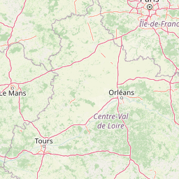
Map view of Réserve naturelle régionale du coteau et plateau de Tessé

Use this park location map to pinpoint Réserve naturelle régionale du coteau et plateau de Tessé in France, understand its exact geographic position, and read its mapped placement within the surrounding landscape more clearly.

Pigeon | © OpenStreetMap contributors

Location context for Réserve naturelle régionale du coteau et plateau de Tessé

Pays de la Loire

Explore protected limestone terrain, dry calcareous grassland habitats, and regional landscape character.

Visualizing Réserve naturelle régionale du coteau et plateau de Tessé Photos and Scenery

Photographs capture the exposed oolithic limestone slopes, rocky plateau terrain, and rare flora defining Réserve naturelle régionale du coteau et plateau de Tessé. Visual documentation reveals the distinct micro-topography and specialized botanical communities thriving across the Rutin valley.

A wide, open landscape showing grassy meadows and plateaus under a clear blue sky, with a few scattered trees in the distance.

Park atlas

Compare nearby regional nature reserves and protected landscapes across the Sarthe department

Parks Near Réserve naturelle régionale du coteau et plateau de Tessé and Surrounding Protected Areas

Browsing other protected areas near Réserve naturelle régionale du coteau et plateau de Tessé reveals broader regional patterns in calcareous grassland conservation. Comparing surrounding limestone terrain helps contextualize local dry-habitat biodiversity within northwestern France.
Nature reserveFrance
About 32 km away#1 closest

Northwest

Réserve naturelle régionale géologique de Normandie-Maine: Geological Nature Reserve

A protected Ordovician limestone site in the Armorican Massif

Located in northwestern France, this reserve focuses on the geological preservation of the Carrière des Vaux. It is an essential site for understanding Paleozoic biostratigraphy, featuring well-exposed limestone sequences and significant microfossil deposits that allow for precise dating of regional strata within the Normandie-Maine landscape.

Area
0.006 km²
Established
2009
Relief
Lowland
Climate
Temperate
Nature reserveNormandie
About 37 km away#2 closest

Northeast

Réserve naturelle régionale de la clairière forestière de Bresolettes: Normandy Protected Landscapes

Mapping forest ecosystems and historic industrial water features in the Perche region.

Spanning roughly 780 hectares, this regional nature reserve serves as a vital biodiversity refuge in northwestern France. The landscape integrates mature woodland, wet meadows, and mire ecosystems that support rare flora and specialized fauna, offering a clear view of the complex environmental history of the Perche forest.

Area
7.8 km²
Established
2010
IUCN
IV
A pale watercolor landscape painting showing rolling green hills and distant mountain ridgelines against a white background.
Nature reservePays de la Loire
About 37 km away#3 closest

West

Réserve naturelle régionale Mont des Avaloirs: Protected Landscape and Geographic Overview

Upland heath and summit geography of the Armorican Massif

Investigate the unique physical geography of Réserve naturelle régionale Mont des Avaloirs. This area acts as a biodiversity stronghold in northwestern France, defined by a dramatic interplay of stony blockfields, sheltered valley brooks, and protected peatland basins that create atypical ecological conditions across the Mayenne countryside.

Area
3.211 km²
Established
2020
IUCN
IV
Relief
Mountain
A watercolor illustration of a soft, rolling landscape with green hills, a winding path or stream, and hints of pink flora in the foreground, set against a light background.
Nature reservePays de la Loire
About 44 km away#4 closest

West

Réserve naturelle régionale des landes et tourbière des Égoutelles Geographic Overview

Protected peat bog and wet heathland in Pays de la Loire

Located in Villepail, this nature reserve occupies a sheltered quarry depression in the Mayenne countryside. The site is a study in ecological resilience, featuring approximately one hundred plant species and a diverse fauna of dragonflies and amphibians that thrive in this compact, waterlogged habitat.

Area
0.013 km²
Established
2009
IUCN
IV
Relief
Lowland
A watercolor painting showing a soft, stylized landscape with rolling green hills, small clusters of trees, and a winding waterway, with tall grass and flowers in the foreground.
Nature reservePays de la Loire
About 48 km away#5 closest

South

Réserve naturelle régionale du bas-marais tourbeux de la Basse-Goulandière: Regional Wetland Mapping

A rare alkaline lowland peatland within the Pays de la Loire administrative region

Examine the mapped terrain and habitat structure of this protected peatland near Le Mans. This site preserves an uncommon alkaline mire environment, serving as an essential ecological bridge within the Roule-Crottes stream valley and demonstrating the significant conservation value of small, high-quality wetland pockets in agricultural landscapes.

Area
0.38 km²
Established
2011
IUCN
IV
A horizontal watercolor painting depicting a soft-toned landscape with a rocky scree slope in the foreground and rolling hills under a pastel sunset sky.
Nature reserveNormandie
About 59 km away#6 closest

West

Réserve naturelle régionale des pierriers de Normandie: Geographic Scree Slope Atlas

Examining rocky protected terrain in Normandy, France

The Réserve naturelle régionale des pierriers de Normandie protects one of the most distinctive natural scree slopes in northwestern Europe. This site preserves fragile rocky debris fields that support specialized vegetation and invertebrate communities. Our atlas data offers a close look at the boundaries and geological character of this significant protected landscape in the Orne department.

Area
0.009 km²
Established
2018
IUCN
IV
Scope
Terrestrial
Nature reservePays de la Loire
About 76 km away#7 closest

South

Réserve naturelle régionale du coteau et prairies des Caforts: Protected Area and Map Atlas

A diverse protected landscape in the Pays de la Loire region

Situated in the Loir valley, this regional nature reserve combines three distinct landscape types: dry limestone slopes, humid hay meadows, and 910 meters of man-made tuffeau quarry galleries. The site represents a significant pocket of biodiversity, hosting sixteen bat species and rare flora within its compact protected footprint in Sarthe.

Area
0.064 km²
Established
2009
IUCN
IV
Nature reservePays de la Loire
About 78 km away#8 closest

South

Réserve naturelle régionale des prairies et roselière des Dureaux: Loir Valley Protected Landscapes

Regional Nature Reserve in Pays de la Loire, France

Spanning the alluvial plains near Vaas, this reserve protects essential wet meadows and reedbed communities shaped by the seasonal rhythm of the Loir River. The landscape features a classic bocage character, offering a distinct example of wetland conservation within the Pays de la Loire region.

Area
0.253 km²
Established
2001
IUCN
IV
Relief
Lowland

Common questions about visiting, size, designation, and location context for Réserve naturelle régionale du coteau et plateau de Tessé

Réserve naturelle régionale du coteau et plateau de Tessé FAQs for park facts, access, geography, and protected area context

Find quick answers about Réserve naturelle régionale du coteau et plateau de Tessé, including protected-area facts, park geography, trail and visitor context, and how the park fits into its surrounding country and regional landscape.
MoriAtlas Explorer

Continue Your Protected Areas Search Across the Global Atlas

Deepen your exploration by continuing the structured search for national parks and protected areas worldwide. Utilize the comprehensive filtering capabilities to compare different conservation landscapes and refine your understanding of global park geography. Discover more about the distribution and characteristics of protected natural areas.

Global natural geography